EARTH FROM SPACE - DIE ERDE AUS DEM ALL - Satelliten-Gemälde | Satellite Paintings - Susen ...
←
→
Transkription von Seiteninhalten
Wenn Ihr Browser die Seite nicht korrekt rendert, bitte, lesen Sie den Inhalt der Seite unten
EARTH FROM SPACE – DIE ERDE AUS DEM ALL
        Satelliten-Gemälde | Satellite Paintings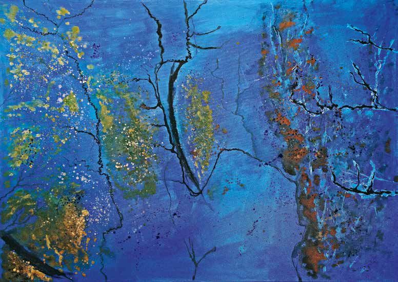
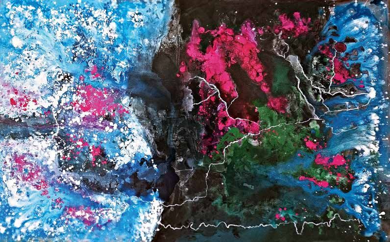
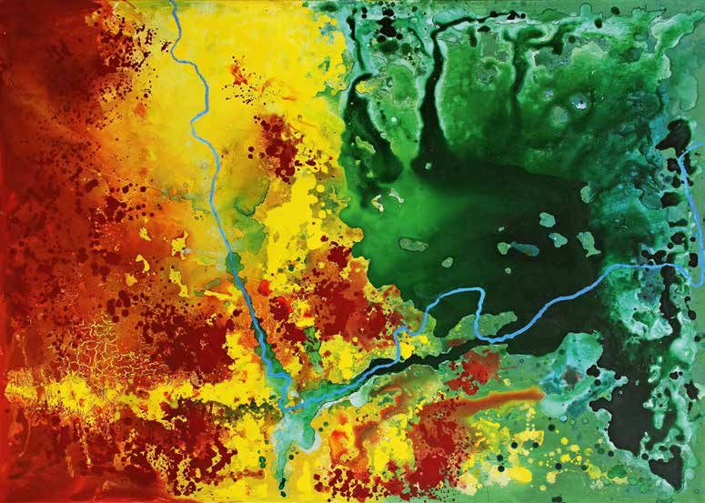
LANDSCAPES IN MOTION I
Maße: 160 x 100 cm | Acryl & Gouache auf Leinwand

Dieses Gemälde entstand auf Grundlage einer Radaraufnah-
me vom Space Shuttle Endeavour im Jahr 1994 über dem
Kruger Nationalpark. Die Radardaten wurden von Prof. Dr.
Christiane Schmullius für ökologische Fragestellungen der
Nationalparkverwaltung hinsichtlich Bewuchs eines Über-
schwemmungsgebietes eingefärbt.

This painting is based on a radar image from the Space Shuttle Endeavour in
1994 from Kruger National Park. The radar data were obtained from Prof. Dr.
Christiane Schmullius and coloured for ecological questions of the national park
administration regarding vegetation of a flood area. The colour selection and spe-
cification by remote sensing methodology and the clearly recognizable river veins
of the wilderness are sources of inspiration for this artwork.
GEO ART
EINE AUSSERGEWÖHNLICHE BEGEGNUNG                                                             GEO ART
ZWISCHEN KUNST UND WISSENSCHAFT                                                              AN INTERSECTION BETWEEN
                                                                                             THE WORLD OF ART AND SCIENCE

Die Erde aus dem All. Momentaufnahmen, die Landschaftsausschnitte im südlichen Af-           The Earth from space. Moments that show parts of land-

rika zeigen und die davon berichten, wie fragil die Ökosysteme unseres Planeten auf Ver-     scapes in southern Africa, reporting about the fragility
                                                                                             of our planet's ecosystems. Satellite images of research
änderungen reagieren. Satellitenbilder von Forschungsgebieten – künstlerisch übersetzt
                                                                                             areas – artistically translated into large-format canvas
in großformatige Leinwandgemälde.                                                            paintings.

                                                                                             Satellite images reveal surface structures of the Earth,
Satellitenbilder lassen Oberflächenstrukturen der Erde sichtbar werden, die in ihrer fili-
                                                                                             which have an immense artistic impact in their incre-
granen Formen- und Farbvielfalt eine immense künstlerische Wirkung besitzen. Mit den         dible variety of shapes and colours. The large-format
großformatigen Gemälden soll auf Arbeiten von Jenaer Forschern im südlichen Afrika           paintings are intending to refer to the work of researchers
hingewiesen werden, die einen wichtigen Beitrag zum Schutz von Ökosystemen leisten.          in southern Africa, representing an important contribu-
                                                                                             tion to the protection of ecosystems. Geographers of the
Jenaer Geographen arbeiten derzeit an einem einheitlichen und wissenschaftlich basier-
                                                                                             University Jena are currently working on a standardized
ten Verfahren zur Bewertung von Landdegradation (einer nicht nachhaltigen Verände-           and scientifically based method for assessing land degra-
rung der Landoberfläche) in Südafrika. Hierfür werden degradierte Flächen mithilfe von       dation in South Africa. For this purpose, degraded areas

Erdbeobachtungsdaten der europäischen ESA-Satelliten Sentinel-1 und Sentinel-2 in            are analysed with the help of Earth observation data
                                                                                             from the European ESA satellites Sentinel-1 and Senti-
ihrem Umfeld analysiert. Diese Satelliten-Aufnahmen sind Inspirations- und Schaffens-
                                                                                             nel-2. These satellite images are the basis of inspiration
grundlage für die Entstehung der Gemälde.                                                    and creation of the paintings.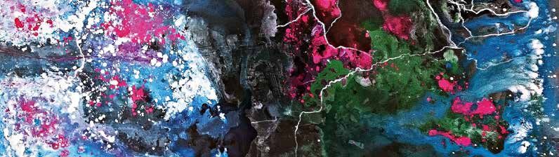
ZIELE DES KUNSTPROJEKTES

1. Kunst und Wissenschaft miteinander verknüpfen                     Aims of the art project

                                                                     _ develop a connection between science and art
2. Wissenschaft für Kunstinteressierte erlebbar machen
                                                                     _ using art as a medium to foster understanding about
                                                                       the work of scientists
3. filigrane, farben- und formenreiche Details der Infrarot- und
                                                                     _ richly coloured and shaped details of Earth
   Radaraufnahmen werden künstlerisch interpretiert                    observation data are interpreted artistically in form
                                                                       of large sized paintings

4. für das menschliche Auge unsichtbare Oberflächenstrukturen bzw.   _ remote sensing provides an insight into patterns and

   Vegetationsbeschaffenheiten werden durch die Radarfernerkundung     structures that are invisible to human eyes

   erst sichtbar
LANDSCAPES IN MOTION II Maße: 140 x 100 cm | Acryl & Gouache auf Leinwand Weite Ebenen im Kruger Nationalpark werden durch Erhebungen mit Steigungen von mehr als 40 Prozent unterbrochen und prägen so die Landschaft. Um Hö- heninformationen effizienter für die Bestimmung von Ve- getationsveränderungen nutzen zu können, arbeitet die Universität Jena an der Ableitung höchstaufgelöster Höhen- modelle. Als Grundlage dienen Luftbilder, aufgenommen von flugzeuggestützten Kameras. Dieses Werk ist inspiriert von einer Sentinel-2 Falschfarbkomposite, entstanden im Südosten, ca. 10 km vor der Grenze zu Mosambik. Wide plains in the Kruger National Park are interrupted by elevations with gra- dients of more than 40 percent and thus shape the landscape. In order to be able to use altitude information more efficiently in the future to determine changes in vegetation, Kai Heckel (Department for Earth Observation, University Jena) is working on deriving high-resolution altitude models. Aerial photos taken from aircraft-based cameras serve as the basis. This work is inspired by a Sentinel-2 false color composite, created in the southeast, about 10 km from the border with Mozambique.
SATELLITEN-GEMÄLDE:
WISSENSCHAFT MIT DEN AUGEN DER KUNST BETRACHTET

Die Kunstgemälde dieses Projektes basieren auf den Daten von Satellitenaufnahmen, die im Rahmen der Fernerkundung ausgewertet
und verarbeitet werden. Fernerkundung ist ein hilfreiches Instrument, um Informationen für die Bewirtschaftung natürlicher Ressour-
cen zu erhalten: für die Überwachen der Bodennutzung, zum Kartieren von Feuchtgebieten und von Lebensräumen wildlebender
Tiere. Auch tragen die Informationen dazu bei, die Schäden zu minimieren, die das städtische Wachstum für die Umwelt verursacht.
Erdbeobachtung ist eine Entscheidungshilfe bei der Fragestellung, wie natürliche Ressourcen geschützt werden sollen.

WHAT IS REMOTE SENSING?
Remote sensing is the science of obtaining information about objects or areas from a distance, typically from satellites,
but also from air- and spacecrafts. Natural light wavelengths used range from visible to infrared and to very long radar wavelengths.
Remote sensing is an instrument to gain information for natural resource management: to monitor land use,
to map wetlands and to chart wildlife habitats or help to minimize the damage that urban growth causes to the environment.
Earth observation helps to decide how to protect natural resources.
AUSSTELLUNGEN | EXHIBITIONS
»EARTH FROM SPACE – SATELLITE PAINTINGS«
NOVEMBER 2020 MÄRZ 2021
D e ut sch l a n d / G e r m any Süda f r i k a / So uth A f r i ca
Friedrich-Schiller-Universität Jena Conference Center Skukuza
Universitätshauptgebäude, Savanna Science Network Meeting 2021
Ausstellungskabinett
Main University Building, Exhibition Cabinet University of Pretoria
SALDi Summer School 2021
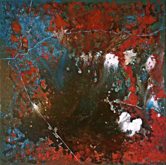
Weitere Ausstellungen in Planung – Termine & Details unter (further information): www.susenreuter.comLANDSCAPES IN MOTION III Maße: 80 x 80 cm | Acryl & Gouache auf Leinwand Die Vegetation der Savanne unterliegt auch in Schutzgebie- ten einem stetigen Wandel. Um deren zeitliche Veränderung im Kruger National Park zu erforschen, nutzt Dr. Christian Berger (Lehrstuhl für Fernerkundung, Universität Jena) im Rahmen des Projektes EMSAfrica (Ecoysystem Management Support for Climate Change in Southern Africa) sowohl ra- darbasierte als auch optische Erdbeobachtungsdaten. Als Inspirationsquelle für das vorliegende Kunstwerk diente eine optische Aufnahme des Satelliten Sentinel-2A. Diese entstand über einem Gebiet im südlichen Teil des National- parks in der Nähe von Skukuza. The vegetation of the savanna is also subject to constant change in protected areas. To investigate the temporal change of vegetation in the Kruger National Park, Dr. Christian Berger (Department for Earth Observation, University Jena) is using both radar-based and optical Earth observation data within the project EMSAf- rica (Ecoysystem Management Support for Climate Change in Southern Africa). An optical image of the Sentinel-2A satellite served as the source of inspiration for this artwork.
PROJEKTPARTNER
Das außergewöhnliche und zugleich interdisziplinäre Konzept »GEO ART – DIE ERDE AUS DEM ALL« ist ein gemeinschaftliches Projekt
von Prof. Dr. Christiane Schmullius (Geographin und Fernerkundlerin) und Susen Reuter (Bildende Künstlerin).

       Prof. Dr. Christiane Schmullius

       • deutsche Geographin und Hochschullehrerin
       • Inhaberin des Lehrstuhls für Fernerkundung der Friedrich-Schiller-Universität Jena
       • von 1994 bis 2000 an drei Space-Shuttle-Missionen beteiligt
       • 2007-2011: Mitglied des beratenden Ausschusses für Erdsystemwissenschaften
          (Earth Science Advisory Committee) der Europäischen Weltraumorganisation (ESA)
       • 2010-19: Vorsitzende des Senatsausschusses des Deutschen Zentrums für Luft- und Raumfahrt
       • 2010: Auszeichnung mit dem Bundesverdienstkreuz 1. Klasse für Verdienste im Bereich Lehre
                                                                                                          Department for Earth Observation
       • German geographer, remote sensing scientist and university teacher                               Faculty of Chemistry and Earth Sciences
       • Chair of the Department for Earth Observation at the University Jena
                                                                                                          Friedrich Schiller University Jena (FSU)
       • from 1994 until 2000 Science Team Lead for three Space-Shuttle-Missions
                                                                                                          Loebdergraben 32; D-07743 Jena; Germany
       • 2007-11 Member of the Earth Science Advisory Committee of the European Space Agency (ESA)
                                                                                                          Phone: 0049 (0)3641 94888-0, Secr. -1, Fax: -2
       • 2010-19 Member of the German Aerospace Center (DLR) Senate
       • 2010: 1st Class Federal Cross of Merit for Teaching Achievements
                                                                                                          www.geographie.uni-jena.de/eo
The extraordinary and at the same time interdisciplinary concept »GEO ART - THE EARTH FROM SPACE« is a corporate project of Prof. Dr. Christiane Schmullius (geographer and
remote sensing scientist) and Susen Reuter (visual artist).
Susen Reuter
• freischaffende Künstlerin, Texterin und Autorin
• Universitätsstudium Geographie | Fernstudium Journalismus
• Tätigkeit in entsprechenden Bereichen
• seit 2007: deutschlandweite Ausstellungstätigkeit und Studienreisen
• seit 2013: Gründung des eigenen Unternehmens: Photography & Art; Reutertext
• seit 2017: Mitglied des Verbandes Bildender Künstler Thüringen e. V. und des
Bundesverbandes Bildender Künstlerinnen und Künstler e. V.
Susen Reuter
• freelance artist, copywriter and author
Photography & Art
• University studies: geography | Distance studies: journalism
Am Schönblick 27; D-99425 Weimar; Germany
• occupation: urban marketing and public relations
Mobile: +49 172 3418658; or: +49 3643 9031670
• since 2007: Germany-wide exhibition activity and international study trips
info@susenreuter.de
• since 2013: private foundation: Photography & Art; Reutertext
• since 2017: Member of the Association of Visual Artists Thuringia e. V. and the Federal Association of Fine Artists e. V. www.susenreuter.comLANDSCAPES IN MOTION IV Maße: 100 x 140 cm | Acryl auf Leinwand Dieses Werk entstand aus Daten der deutschen TanDEM-X Radarsatelliten und dient zur GIS-Analyse (Geographische Informationssystem-Analyse) der Bodenoberfläche für das Forschungsprojekt „Contemporary and long-term erosion in a pristine African Savanna, Kruger National Park, Repub- lic of South Africa“. Das Projekt fand unter Leitung von PD Dr. Jussi Baade statt (Lehrstuhl für Physische Geographie der Universität Jena). The painting is based on data from the German TanDEM-X radar-satellites and is used for the GIS-Analysis (Geographic Information-System-Analysis) of the soil surface for the research project „Contemporary and long-term erosion in a pristine African Savanna, Kruger National Park, Republic of South Africa“. The project took place under the direction of PD Dr. Jussi Baade, Department of Phy- sical Geography, University Jena.
Kunst ist ebenso wie Wissenschaft  das Ergebnis menschlicher Kreativität.
 Beide sind wesentliche Elemente unserer Kultur und erschließen weitere und tiefere Ebenen
            unseres Daseins. (...)  Hier wie da gilt es Feingefühl und Achtung vor dem Erbe
 zu haben, wenngleich nur der Mut, neue Wege zu beschreiben,  Raum für Innovationen bietet.
                                      Zitat: Hans P. Schönlaub; Geologe und Paläontologe

    Art as well as science are results of human creativity. Both are essential elements of our culture and open up further
and deeper levels of our existence. (...) In art and science it is important to react with awareness and respect to the heritage,
                        although only the courage to describe new ways offers space for innovations.

                                                                                                                                    Design: LOTOS DESIGN
                                      www.susenreuter.com
Sie können auch lesen