The 1872 catastrophic storm surge at the Baltic Sea coast of Schleswig-Holstein; lessons learned?
←
→
Transkription von Seiteninhalten
Wenn Ihr Browser die Seite nicht korrekt rendert, bitte, lesen Sie den Inhalt der Seite unten
Article, Online First

Hofstede, Jacobus; Hamann, Matthias
The 1872 catastrophic storm surge at the Baltic Sea coast
of Schleswig-Holstein; lessons learned?
Die Küste, 92 (Online First)
Zur Verfügung gestellt in Kooperation mit/Provided in Cooperation with:
KFKI - Kuratorium für Forschung im Küsteningenieurwesen (Hg.)

Verfügbar unter/Available at: https://hdl.handle.net/20.500.11970/108389

Vorgeschlagene Zitierweise/Suggested citation:
Hofstede, Jacobus; Hamann, Matthias (2022): The 1872 catastrophic storm surge at the
Baltic Sea coast of Schleswig-Holstein; lessons learned?. In: Die Küste, 92 (Online First).
https://doi.org/10.18171/1.092101.

Standardnutzungsbedingungen/Terms of Use:

Die Dokumente in HENRY stehen unter der Creative Commons Lizenz CC BY 4.0, sofern keine abweichenden
Nutzungsbedingungen getroffen wurden. Damit ist sowohl die kommerzielle Nutzung als auch das Teilen, die
Weiterbearbeitung und Speicherung erlaubt. Das Verwenden und das Bearbeiten stehen unter der Bedingung der
Namensnennung. Im Einzelfall kann eine restriktivere Lizenz gelten; dann gelten abweichend von den obigen
Nutzungsbedingungen die in der dort genannten Lizenz gewährten Nutzungsrechte.
Documents in HENRY are made available under the Creative Commons License CC BY 4.0, if no other license is
applicable. Under CC BY 4.0 commercial use and sharing, remixing, transforming, and building upon the material
of the work is permitted. In some cases a different, more restrictive license may apply; if applicable the terms of
the restrictive license will be binding.
Die Küste, 92, 2022                                                    https://doi.org/10.18171/1.092101

The 1872 catastrophic storm surge at the Baltic Sea
coast of Schleswig-Holstein; lessons learned?
Jacobus Hofstede1 and Matthias Hamann2
1 Ministerium für Energiewende, Landwirtschaft, Umwelt, Natur und Digitalisierung des Landes
  Schleswig-Holstein, jacobus.hofstede@melund.landsh.de
2 Ministerium für Inneres, ländliche Räume, Integration und Gleichstellung des Landes Schleswig-

  Holstein, matthias.hamann@im.landsh.de

Summary
November 13, 2022 marks the 150th anniversary of the most severe storm surge to date
along the Baltic Sea coast of the German Federal State of Schleswig-Holstein. Thirty-one
people died in the floods and about 15,000 became homeless. It was the last storm surge
in Schleswig-Holstein, in which human lives were lost. Given this and in the face of strongly
increasing mean and extreme sea levels in future, the 1872 storm surge constitutes an ad-
monition or rather a plea for sustainable coastal flood risk management.
Along the Baltic Sea coast of Schleswig-Holstein, peak water levels of the 1872 storm surge
probably varied among about NHN +2.4 and +3.4 meter. The highest local wind speeds
and waves occurred four to 10 hours earlier than peak water levels in Schleswig-Holstein.
The unprecedented height of the 1872 storm surge in Schleswig-Holstein resulted from an
external surge that propagated into the area from the central Baltic Sea region and piled up
here on top of already prevailing very high storm surge water levels. The 1872 storm surge
represents a singular event in Schleswig-Holstein, which makes it scientifically challenging
to assess its probability of occurrence. Present-day coastal flood defense, spatial planning
and disaster management, as cornerstones of public coastal flood risk management in
Schleswig-Holstein, generally and in combination consider the lessons learned after the
1872 flood calamity. In the light of intensifying utilizations, the need to improve the status
of the environment and with regard to stronger rising sea levels in future, implementing
sustainable coastal flood risk management remains a challenge.

Keywords
Schleswig-Holstein, Baltic Sea, storm surge, flood catastrophe 1872, coastal flood defense

Zusammenfassung
Am 13. November 2022 jährt sich zum 150sten Mal die bisher schwerste Katastrophenflut in der west-
lichen Ostsee, bei der allein in Schleswig-Holstein 31 Menschen umkamen und etwa 15.000 obdachlos
wurden. Es war das letzte Sturmflutereignis in Schleswig-Holstein, bei dem Menschenleben zu beklagen
waren. Aus diesem Grund und vor dem Hintergrund stark steigender mittlerer und Extremwasserstände
in der Zukunft, stellt diese Flutkatastrophe eine Mahnung und einen Appell für ein nachhaltiges Manage-
ment von Hochwasserrisiken an den Küsten dar.
Die Küste, 92, 2022                                                       https://doi.org/10.18171/1.092101

Diese Abhandlung beginnt mit einer Beschreibung der Sturmflut des Jahres 1872 und ihrer Folgen in
Schleswig-Holstein. Der Fokus liegt dabei auf den besonders betroffenen Orten Dahme und Eckernförde.
Anschließend wird dargestellt, wie die während der Sturmflut gewonnenen Erkenntnisse in den Jahrzehnten
nach der Sturmflut und heute in der Planung und Umsetzung von Küstenschutzmaßnahmen und des
Hochwasserrisikomanagements generell umgesetzt wurden und werden. Nach einer Ausarbeitung der Kom-
ponenten des integrierten Hochwasserrisikomanagements wird die Abhandlung mit einer Diskussion über
die Lehren aus der Sturmflut fortgesetzt. Sie endet mit den nachfolgenden Schlussfolgerungen.
Die Sturmflut von 1872 erreichte an der Ostseeküste von Schleswig-Holstein wahrscheinlich maximale
Wasserstände zwischen NHN +2,4 und 3,4 m. Die höchsten lokalen Windgeschwindigkeiten und Wel-
len traten in Schleswig-Holstein vier bis 10 Stunden früher auf als die Höchstwasserstände. Die einzigartige
Höhe der Sturmflut vom 13. November 1872 in Schleswig-Holstein wurde durch eine externe Flutwelle
aus dem zentralen Ostseeraum verursacht, die sich auf bereits vorherrschende sehr hohe Sturmflutwasser-
stände auftürmte. Entsprechend stellt die Sturmflut in Schleswig-Holstein ein singuläres Ereignis dar,
weshalb seine statistische Einordnung eine wissenschaftliche Herausforderung darstellt. Als Hauptbestand-
teile eines integrierten Hochwasserrisikomanagements an den Küsten berücksichtigen Küstenschutz, Raum-
ordnung und Katastrophenschutz in Schleswig-Holstein generell und in Kombination die nach der Flut-
katastrophe gesammelten Erfahrungen. Vor dem Hintergrund intensiver Nutzungen und die Notwendig-
keit einer ökologischen Zustandsverbesserung sowie im Hinblick auf den beschleunigten Meeresspiegelan-
stieg bleibt die Umsetzung eines nachhaltigen Küstenhochwasserrisikomanagements eine Herausforderung.

Schlagwörter
Schleswig-Holstein, Ostsee, Sturmflut, Flutkatastrophe 1872, Küstenschutz

1    Introduction
November 13, 2022 marks the 150th anniversary of a catastrophic storm surge that hit the
coastlines of the western Baltic Sea region. In Germany, Denmark and Sweden, about 300
people died, 127 of them at sea (Fredriksson et al. 2017, Kiecksee 1972). In the German
Federal State of Schleswig-Holstein (Figure 1), 31 people died in the floods, about 2,850
houses were destroyed or uninhabitable and more than 15,000 persons became homeless
and needy (Kiecksee 1972). It was the last storm surge in Schleswig-Holstein, in which
human lives were lost. Since 1872, the number of inhabitants and physical assets or, rather,
tangible damage potentials have multiplied.
Die Küste, 92, 2022 https://doi.org/10.18171/1.092101
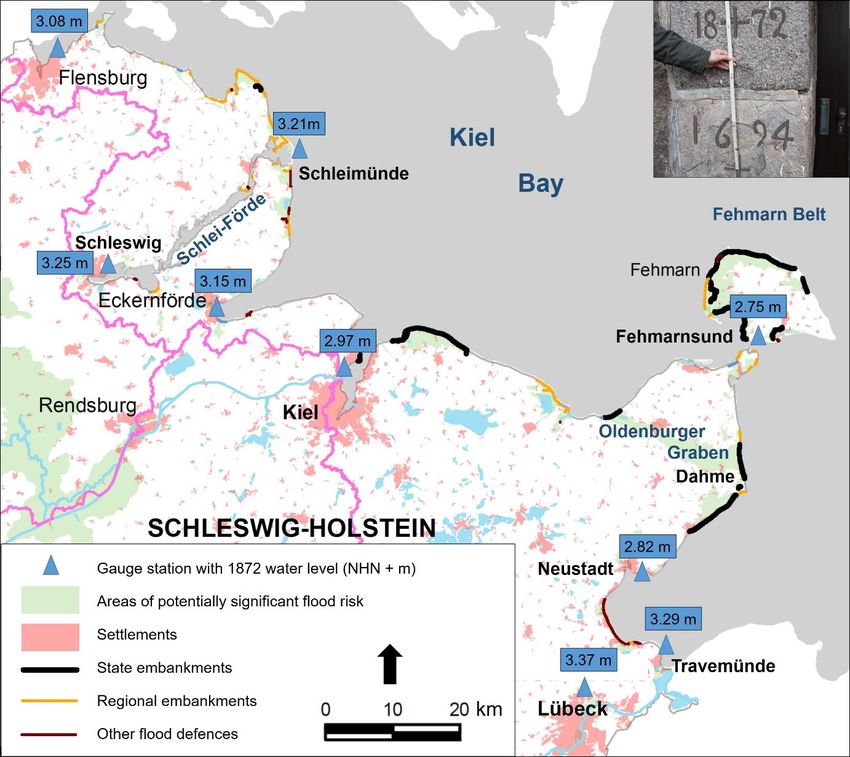
Figure 1: overview of the Baltic Sea coast of Schleswig-Holstein with coastal lowlands (in green),
coastal flood defenses and 1872 storm surge water levels (gauge data: NHN = “Normalhöhennull”
= German ordnance datum). The inset at the top right of the figure shows high water marks from
the storm surges 1694 and 1872 at the former Gottorf water mill in Schleswig (photo: J. L. A.
Hofstede).
Today, more than 30,000 people live and damage potentials of almost seven billion Euros
are present in the about 315 km2 large coastal lowlands along the Baltic Sea of Schleswig-
Holstein. MELUND (in press) defines these lowlands as the areas situated less than 2.5 m
above German Ordnance Datum NHN (≈ mean sea level). This is the area that could
potentially, i.e., without coastal flood defenses, flood during a storm surge with a yearly
probability of 0.005. Although the flood defense standards have strongly improved since
1872, a comparable storm surge could still have disastrous impacts due to the multiplied
population density and damage potentials. Given this and in the face of strongly rising
mean and extreme sea levels in future (IPCC in Press), the 1872 storm surge in Schleswig-
Holstein constitutes an admonition or rather a plea for sustainable coastal flood risk man-
agement.
This paper starts with descriptions of the storm surge and of its impacts with a focus
on two severely affected municipalities in Schleswig-Holstein: Eckernförde and Dahme.
The next section describes the implementation of the findings, gained during and directly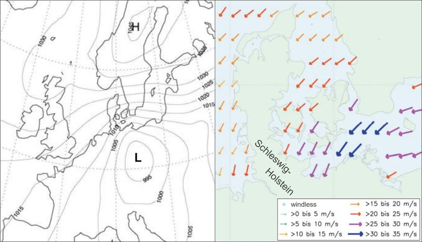
Die Küste, 92, 2022                                                 https://doi.org/10.18171/1.092101

after the 1872 surge, in the planning and execution of coastal flood defense measures and
coastal flood risk management in the following decades and today. After an elaboration of
the components of integrated flood risk management, the paper continues with a discus-
sion about the lessons learned from the storm surge and ends with some conclusions.

2    The 1872 storm surge in Schleswig-Holstein
2.1 Meteorology and hydrology

Figure 2: reconstructed air pressure fields and wind velocities in the western Baltic Sea region on
November 13, 6 a.m. (source: Rosenhagen und Bork 2009).

Although the 1872 storm surge reached its maximum water levels on November 13, the
causative weather situation started already two weeks before (Rodloff 1972, Rosenhagen
und Bork 2009). From November 1 to 10, a strong and stable low-pressure system over
Scandinavia induced strong westerly winds that “pushed” seawater away from the German
Baltic Sea coasts towards the east. This resulted in falling water levels in the western Baltic
Sea and, in compensation, water inflow from the North Sea via the Kattegat. In effect, the
Baltic Sea filled up with water. Around November 10, the weather situation changed, the
westerly winds waned and water started to flow back from the east. A high-pressure system
evolved over Scandinavia, accompanied by a low-pressure system in central Europe. Both
weather systems continually intensified until November 13, when extreme air pressure gra-
dients induced a northeasterly hurricane (Figure 2). Peak wind velocities in Schleswig-
Holstein occurred in the late morning. In Kiel, the hurricane reached a maximum of about
31 m/s around 10 a.m. (Baensch 1875).
   Baensch (1875) comprehensively described the hydrology of the 1872 event, including
the establishment of 23 storm surge curves recorded at Prussian gauges in the Baltic Sea.
Figure 3 depicts coastal flood hydrographs from the gauges Travemünde, Fehmarnsund
(positions in Figure 1) and Stralsund (situated about 135 km to the east of Travemünde)
Die Küste, 92, 2022                                             https://doi.org/10.18171/1.092101

from November 11 to 14. The curves show that water levels continuously rose for more
than two days. Such a long and strong rise of sea levels as well as the resulting maximum
storm water levels were and are unprecedented in the region. Further, the gauge stations
Fehmarnsund and Travemünde visualize the well-known effect of increasing surge levels
from the outer towards the inner parts of bights.

Figure 3: Storm surge curves at Travemünde, Fehmarnsund and Stralsund gauge stations from
November 11 to 14 (adapted from Baensch 1875).

Figure 1 depicts known maximum water levels of the 1872 storm surge at gauge stations in
Schleswig-Holstein. Lübeck gauge station recorded the highest water level in Schleswig-
Holstein with 3.38 m above mean water level (NHN +3.37 m). At the former “Blue
Tower” in Lübeck, high water marks existed of two earlier extreme floods that occurred in
the years 1625 and 1694. A regional railway company dismantled the Blue Tower in the late
19th century to make room for a new railway line. Based on these marks, Baensch (1875)
established maximum water levels of 2.80 m (1625) and 2.82 m (1694) above mean water
level, i.e., 0.58 resp. 0.56 m lower than the flood from 1872. Baensch applied the mean
water level of his time, thus assuming that no secular mean sea level changes occurred
among 1625 and 1872. According to Baensch (1875), no reliable height information exists
of older storm surges, whereas the storm surges that occurred among 1694 and 1872 were
significantly lower. Based on historical data, Jensen et al. (2022) reassessed the heights of
storm surge water levels in Travemünde over the last 1,000 years and concluded that a
comparable surge height as in 1872 may have occurred in 1320. At the former Gottorf
water mill in Schleswig, high water marks exist from the storm surges in 1694, 1836 and
1872 (inset in Figure 1). According to these marks, the peak water level in Schleswig in
1694 was about 0.6 m lower than in 1872, as the water level reached NHN +3.25 m at the
local gauge station (Figure 1).
    Figure 4 depicts the yearly highest water levels (HW) at gauge station Travemünde from
1826 to 2020, one of the world’s longest continuous HW time series. Here, the 1872 water
level reached NHN +3.29 m. The second highest storm surge water level was recorded in
1904 with NHN +2.15 m, i.e., 1.15 m lower than the 1872 peak water level.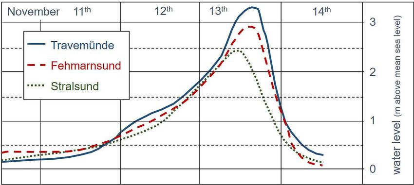
Die Küste, 92, 2022                                                https://doi.org/10.18171/1.092101

Figure 4: the yearly highest water levels at gauge station Travemünde from 1826 to 2020 (data from
LKN.SH; data not corrected for mean sea level rise).

An internal report from the State Water Management Authority Lübeck (WWA Lübeck
1946) lists, for each of the Dike and Drainage Boards on the island of Fehmarn (location
in Figure 1), maximum water levels for the 1872 storm surge. The values vary among 2.37
and 2.68 m above mean sea level. The data stem from local inquiries after the storm surge
and do not have the same accuracy as gauge data. The lowest water levels appeared expect-
edly along the downwind-side western shorelines, the highest to the northeast and in the
Fehmarnsund. The listed water levels are lower than along the mainland coast, which seems
physically plausible. In synthesis, maximum water levels along the Baltic Sea coast of
Schleswig-Holstein probably varied among about NHN +2.4 and +3.4 m.
    Based on reported peak water levels and their occurrence times in the Schlei firth (lo-
cation in Figure 1), Baensch (1875) established a mean progression velocity of the surge
wave in this firth with about seven km per hour. The lowest speeds occurred at the mouth
and in the broader inner part of the firth, the highest velocities in the narrow central part.
At the mouth, in Schleimünde, maximum water level (NHN +3.21 m) occurred around
3:30 p.m. At the inner end, in Schleswig, water level reached its maximum (NHN +3.25 m)
around 9:30 p.m., i.e., almost 10 hours later than the maximum wind velocities in the region
(see above). Baensch (1875) reported that peak water levels within the Schlei decreased
from the mouth towards the inner parts. At the broader inner end of the firth, however,
local surge levels increased again and even exceeded the values observed at the mouth (Fig-
ure 1). This kind of surge progression is typical for the Schlei and probably relates to its
particular shape.

2.2 Impacts
In 1872, large parts of the coastal lowlands along the Baltic Sea coast of Schleswig-Holstein
were still unprotected. Only some lowlands like the Oldenburger Graben (Figure 5) already
featured coastal flood defenses. As these under dimensioned defenses all collapsed during
the storm surge, the impacts in Schleswig-Holstein were disastrous. More than 300 km2 of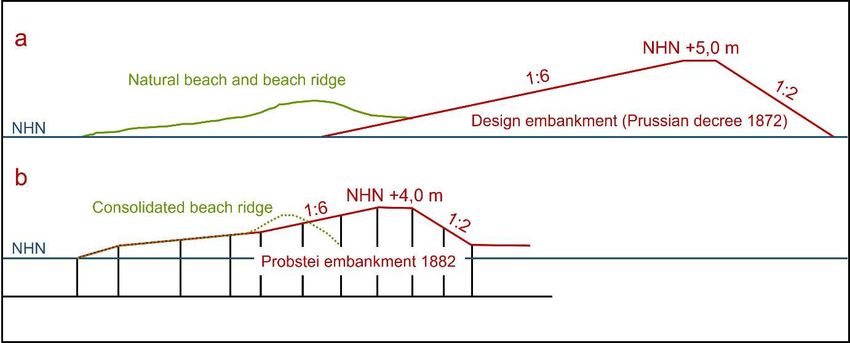
Die Küste, 92, 2022 https://doi.org/10.18171/1.092101
coastal lowlands with numerous settlements as well as harbor areas of larger towns like
Flensburg and Lübeck flooded. According to Kiecksee (1872), the floods damaged or ru-
ined about 2,850 houses, 31 people died and more than 15,000 persons became homeless
and needy. Kiecksee (1972) gives a comprehensive and regionalized overview of the flood
impacts and of the recovery measures after the flood in the western Baltic Sea region. With
numerous data and facts, he documents that not only the surge and its impacts, but also
the public and private readiness to help after the catastrophe were unprecedented. This
subchapter contains a description of the catastrophic impacts in two particularly affected
villages in Schleswig-Holstein: Dahme and Eckernförde.
Dahme is a small coastal municipality with about 1,250 inhabitants (Figure 1 and 5).
With almost one million overnight stays per year, seaside tourism dominates local economy.
Parts of Dahme lie in the about 43 km2 large coastal lowland Oldenburger Graben. In this
lowland, about 1,900 people live and 366 million Euros of capital assets exist (Fachplan
Küstenschutz Ostseeküste 2022).
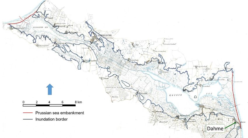
Figure 5: historical map from 1878 showing embankments and inundated area in the coastal low-
land “Oldenburger Graben” (location in Figure 1) during the 1872 storm surge (source: LASH
Abt. 402 A 24 Nr. 36).
In the late 1860ies, as part of a socio-cultural aid for the newly established province of
Schleswig-Holstein, the Prussian Government initiated a comprehensive coastal flood de-
fense program (Kannenberg 1958). One of the first larger measures was, in 1868 and 1869,
the erection of an about 5.5 km long sea embankment in front of Dahme and the Olden-
burger Graben (Figure 5). It was probably designed based on observations from the last
severe storm surge that had occurred in the region in 1836 (Figure 4). This storm surge
resulted in maximum water levels of about 2.0 m. In all, the embankment was about 3.0 m
high, considering a local wave run up of about 1.0 m. The embankment, that consisted of
sandy material and had relatively steep slopes, lay on top of dunes and beach ridges. No-
vember 1872, three years after finalization of the flood defense, storm surge water levels in
the area rose to about 2.8 m above normal. Unsurprisingly, the embankment collapsed,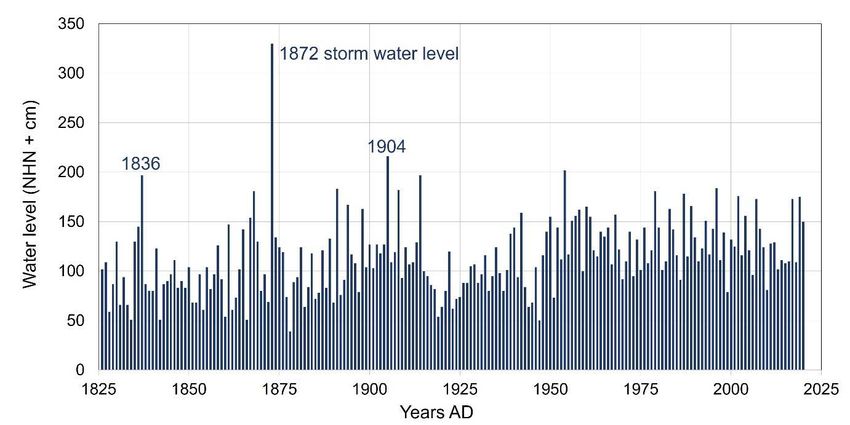
Die Küste, 92, 2022 https://doi.org/10.18171/1.092101
amongst others directly in front of Dahme (Kiecksee 1972). After breaching of the de-
fenses, the floodwaters swiftly inundated not only large parts of the village, but also the
Oldenburger Graben (Figure 5). Ten persons died in the floods in Dahme, more than in
any other municipality in Schleswig-Holstein. According to Reher (1931), only 20 from 80
to 90 houses that originally existed in the village were still inhabitable after the flood. The
strong flood currents ruined 40 to 50 houses and washed 20 other houses away. In all, 51
families with about 300 persons (i.e., more than half of the total population) became home-
less. Most of the livestock drowned.
Eckernförde is a coastal city with about 21,700 inhabitants (Figure 1). It is situated in
the inner part of Eckernförde Bight that faces towards the northeast, i.e., that is directly
exposed to northeasterly storms and waves. Major parts of the inner city are flood prone
coastal lowland (Figure 6). Here, about 1,250 people live and 130 million Euros of capital
assets exist (Fachplan Küstenschutz Ostseeküste 2020). In contrast to Dahme, there are no
technical flood defenses in Eckernförde. An elevated promenade on former beach ridges,
partly protected by revetments, and an elevated harbor area protect the low-lying inner city
from flooding. Responsible city authorities are planning a comprehensive flood defense
scheme (PROKOM 2017).
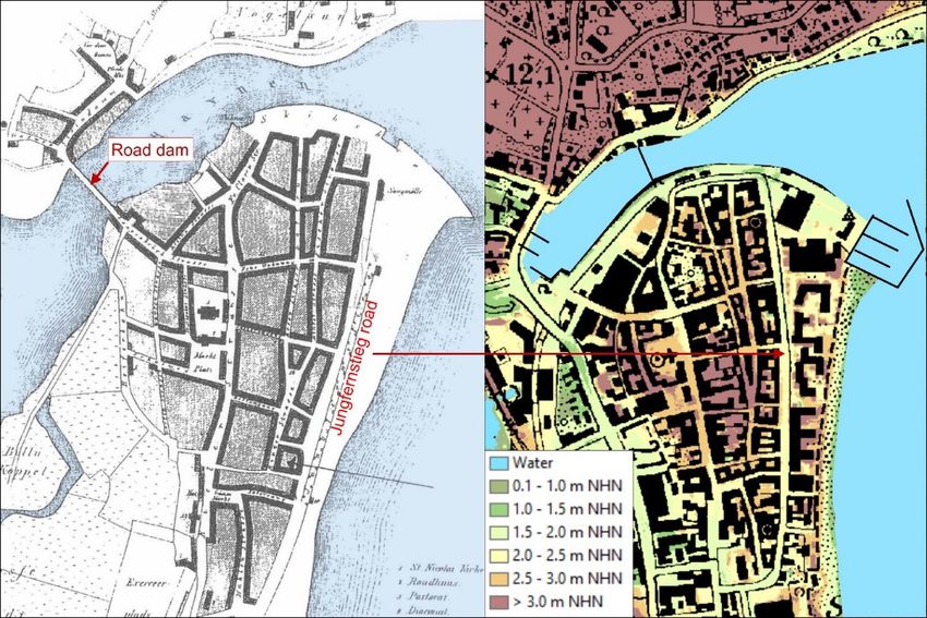
Figure 6: Maps of the city of Eckernförde. The left image displays a historical map from 1864
(source: PROKOM 2017). The right image shows the present situation; including hypsometric
layers; note that the green and yellow areas are flood prone (source: KIS-SH).
As no flood defenses existed in 1872, the rising waters more or less steadily inundated the
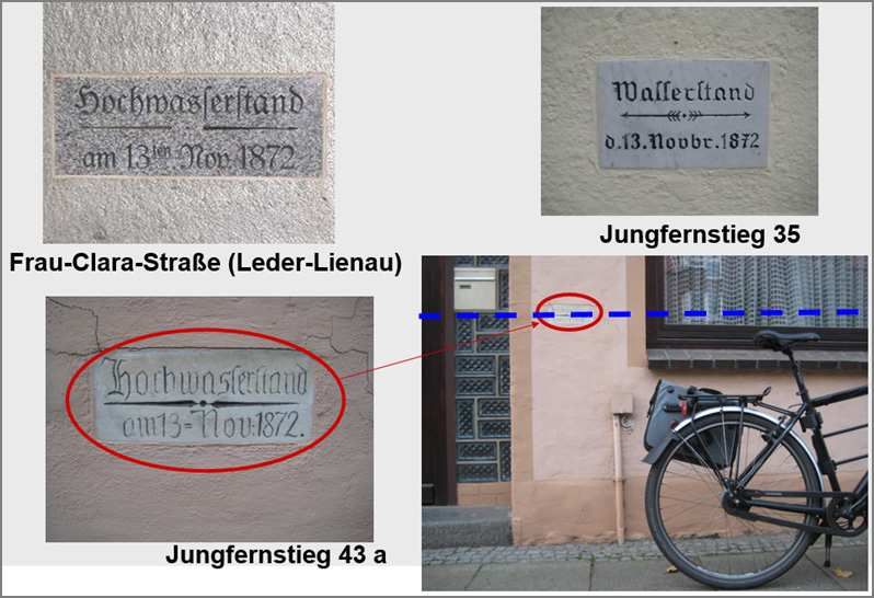
city. Most of the damages to buildings occurred along the “Jungfernstieg” road (Figure 6)
and resulted from wave impacts. Flood marks on both sides of this road, however, show
that some of them withstood the flood (Figure 7).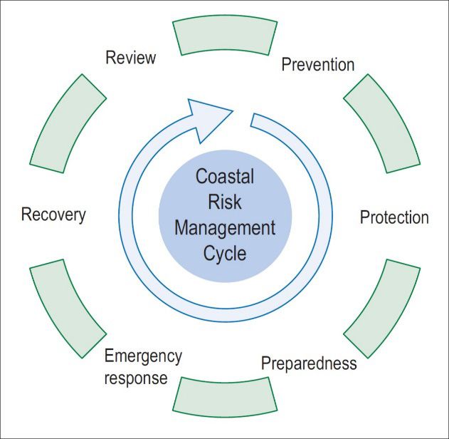
Die Küste, 92, 2022                                              https://doi.org/10.18171/1.092101

Figure 7: Flood marks in the historical town center of Eckernförde (photos: M. Hamann).

The devastation in Jungfernstieg actually furthered the upcoming fish industry. In the
“cleared” space, it was easy to raise e.g. new smokehouses, which contributed to following
decades of economic prosperity (Schinkel 2001). Despite of the 1872 calamity, new build-
ings arose even at the seaward (eastern) side of the road. As shown in Figure 6 (left image),
first developments on existing beach ridges had only started here after 1864. Until the mid-
1970s, commercial uses prevailed along the seaward side of the Jungfernstieg. Afterwards,
the area converted into a residential area. In all, waves and currents destroyed 78 houses
and damaged 138 in the 1872 storm flood (Kiecksee 1972). After the catastrophe, 112 fam-
ilies were homeless and 150 to 160 families with about 400 persons needy. Although the
numbers of damaged houses and needy persons after the flood were significantly higher in
Eckernförde than in Dahme, nobody died here in the floods.

2.3 Statistical appraisal of the 1872 storm surge
From Figure 4, it becomes clear that the 1872 water level clearly stands out. In relation to
NHN, the peak water level in 1872 is more than 50% higher than the second highest rec-
orded water level. From a statistical point of view, this is an indication that, in Schleswig-
Holstein, the event is an outlier that does not belong to the population. This makes it sci-
entifically challenging to assess its probability of occurrence. The German joint research
project MUSTOK (Jensen 2009) investigated meteorology and hydrology of the 1872
event. Mudersbach and Jensen (2009) corrected the 1872 value at gauge station Trave-
münde (Figure 4) for mean sea level rise until 2006. With a newly established distribution
function, they calculated a recurrence interval of 10,000 years for the 1872 storm surge
water level if it would reoccur in 2006. They concluded that the statistical population used
could not describe the storm surge. Extending the population with historical data (inter
alia, the 1625 and 1694 peak water levels) and modelling results on hydro-meteorologically
possible extreme water levels in the region (Bork and Müller-Navarra 2009) reduced the
Die Küste, 92, 2022                                             https://doi.org/10.18171/1.092101

recurrence interval of the event to about 3,400 years. Based on numerical modelling of the
1872 event, Bruss et al. (2009) stated that the extreme peak water levels in Schleswig-
Holstein resulted mainly from a combined water transport into the area from the central
Baltic Sea and the Kattegat, driven by an extraordinary supra-regional meteorological situ-
ation rather than by local weather.
    The fact that peak water levels in Schleswig-Holstein occurred four to 10 hours later
than the observed maximum local wind velocities (Baensch 1875), supports this hypothesis.
In Kiel, for example, after a maximum of 31 m/s around 10:00 a.m., local wind velocity
was in the order of 17 m/s during peak water level around 3:30 p.m. (Figure 8). Although
the local wind already decreased, the water level in Kiel still rose by more than 0.5 m. In
Schleswig, local wind velocity was probably less than 10 m/s during peak water level.
Hence, highest wind velocities and peak water levels did not coincide in Schleswig-
Holstein. This indicates that an external surge wave, caused by a northeasterly hurricane in
the central Baltic Sea region, entered Kiel Bay via the Fehmarn Belt and approached the
coastline of Schleswig-Holstein. Here, it piled up on top of already raised storm water lev-
els. Without the external surge wave, peak water levels may have resembled those of the
1625 and 1694 storm water levels in Schleswig-Holstein (see Ch. 2.1). This extraordinary
multi-causal emergence of local peak water levels supports the hypothesis that the 1872
storm surge represents a singular event in Schleswig-Holstein. Further, the time lag among
highest wind velocities and peak water levels indicates that, fortunately, maximum wind
waves probably occurred several hours before peak water levels in Schleswig-Holstein.

Figure 8: wind curve (dotted line) and flood hydrograph of the 1872 storm surge at Kiel gauge
station (taken from Baensch 1875).

3    Coastal flood defense after the 1872 storm surge
Less than one month after the catastrophic flood, Prussian Government passed a decree
for a comprehensive coastal flood defense program, including design criteria (Kannenberg
1958). One forward-looking criteria was that new sea embankments should be erected
Die Küste, 92, 2022 https://doi.org/10.18171/1.092101
sufficiently landward of dunes and beach ridges, instead of on top of them. Based on ob-
servations made during the storm surge (Baensch 1875), this measure envisaged a reduction
in hydraulic loads on the outer slope of the embankments as well as the creation of a buffer
zone for coastal erosion during storm surges. After evaluation of the 1872 hydraulic loads,
it was further stipulated that:
• the height of the new embankments should be about 5.0 m above mean sea level,
• the crest width should be about 3 to 4 m,
• the outer slope should have a gradient of 1:6, the inner slope 1:2,
• the embankment should have a cover of at least 0.6 m of erosion resistant material
like clay.
Figure 9a visualizes the Prussian standard design for sea embankments (Eiben 1992). In
the building campaigns after 1872, one-to-one implementation of this design did not occur
(Kannenberg 1958). Although the erection of new embankments normally took place be-
hind natural dunes and beach ridges, mean height of the embankments was normally up to
about four meter above mean sea level. The outer slopes had gradients among 1:3 and 1:6;
the inner slopes were normally steeper than 1:2. For most embankments, no information
exists about their composition. Figure 9b displays the profile of the sea embankment in the
Probstei near Kiel from 1882. With a maximum height of NHN +4.0 m, it lies directly
behind the beach and partly on top of a pre-existing consolidated beach ridge.
Figure 9: design profile of a sea embankment according to the Prussian design criteria (Figure 9a)
and of the 1882 sea embankment in the Probstei near Kiel (Figure 9b) (adapted from Eiben 1992).
Until 1882, with technical and financial support from the Prussian Government, about
70 km of sea embankments arose along the Baltic Sea coast of Schleswig-Holstein
(Kannenberg 1958). These defenses protect about 145 km2 of coastal lowlands. Newly
founded Dike and Water Boards became the task to maintain the embankments and secure
the drainage of the lowlands. In these boards, all potentially affected landowners were
member (with the power of co-decision according to landholding). In the year 1972, upon
request of the boards, Schleswig-Holstein State Government took over technical and fi-
nancial responsibility for the sea embankments. Conform the Schleswig-Holstein State Wa-
ter Act, these coastal flood defenses passed as rededicated state embankments into state
ownership.Die Küste, 92, 2022 https://doi.org/10.18171/1.092101
One of the first measures after 1872 was the erection of a 5.5 km long new embankment
in front of Oldenburger Graben near Dahme (Kannenberg 1958). The new crest height
was about 4.2 m above mean sea level. Outside of Dahme, the new embankment ran be-
hind the dunes and beach ridges, as stipulated in the Prussian decree. In front of Dahme,
due to limited space, the new embankment lay again in an exposed situation directly behind
the beach and featured relatively steep paved slopes. The expectation was that a paved
outer dike slope should be able to withstand the higher hydraulic loads. The embankment
and its foreland came into the possession of the newly founded local Dike and Water
Board. It was governmental intention that the foreland should remain free from utilizations
(Runde 1883). However, the upcoming of seaside tourism thwarted this specification. In
1920, local community erected a swimming pool in front of the embankment (Reher 1931).
A concrete walking trail (promenade) on the foreland of the embankment followed, pro-
tected by a low flood defense wall situated directly on the beach. Based upon a public beach
building plan from 1921, the area behind the wall but in front of the sea embankment
increasingly filled up with touristic infrastructures (Kannenberg 1958). Today, dense tour-
istic utilizations prevail in front of the embankment (Figure 10).
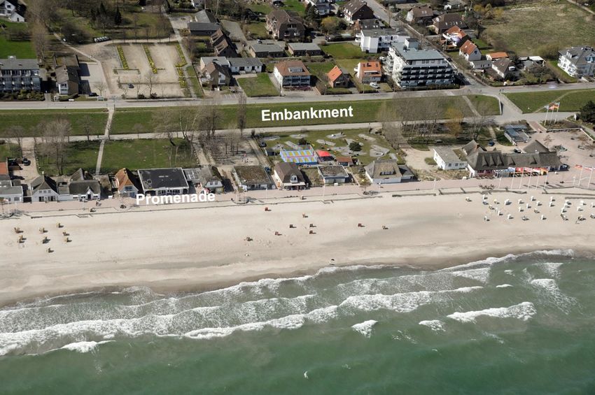
Figure 10: Aerial photo of Dahme seaside (Photo: LKN.SH / VPS).
After taking over the responsibility in 1972 (see above), state administration checked and
listed the state embankment in front of Dahme as unsafe (i.e., not able to withstand the
1872 storm surge). Planning of a strengthening campaign started around the year 2,000.
Achieving formal approval for public coastal flood defense measures may take 10 years or
more in Germany, due to comprehensive state, national and EU legislation as well as the
challenge of achieving local acceptance. The strengthening campaign went from 2010 to
2013 (Hofstede 2011). The design height based on the 1872 storm water level and included
an additional margin of 0.5 m to account for sea level rise. Considering local wave run up,
the existing about 5.5 km long embankment became a new crest height of NHN +4.8 m.
A layer of clay covers a sandy core. Outside of Dahme, about 3.7 km was constructed withDie Küste, 92, 2022 https://doi.org/10.18171/1.092101 a seaward gradient of 1:8 and an inside gradient of 1:3. In Dahme, the challenge was to consider the existing touristic infrastructure on the foreland as well as dense housing and public infrastructure behind the embankment (Figure 10). Existing buildings and uses have a legal right of continuance and local community would not have accepted their removal. In consequence, the seaward gradient remains steeper and, over a stretch of about 0.7 km, a flood defense wall on top of the sea embankment secures the prescribed flood safety standard. Three passages through the embankment that are lockable in case of flood emer- gency enable easy access to the seaside facilities. In order to secure coherence for overbuilt NATURA 2000 sites, a specialized company removed moist dune habitats from the con- struction site and relocated them on prepared new dunes (Hofstede 2011). In synthesis, the new sea embankment fulfills the Prussian design criteria from 1872. 4 Integrated flood risk management In order to minimize the risks of coastal flooding, building flood defenses is only one brick in the wall. Hofstede (2007, 2011b) describes a holistic and integrated approach that com- bines technical and non-technical measures in a coastal flood risk management cycle (Fig- ure 11). Figure 11: The cycle of integrated coastal flood risk management (source: Hofstede 2007). Starting point in the cycle is prevention that aims at avoided or minimized flood risks, e.g., by stipulating building ban zones in flood hazard areas. The objective of protection is a minimized probability of a harmful flood event to occur, e.g., by building sea embank- ments. Preparedness has much to do with flood risk awareness of the affected population and the responsible decision makers (i.e., politicians). An important instrument to achieve this is appropriate risk communication. Informed people are more willing to take resp. order preparatory actions (including evacuation). Further, they accept the high costs and other possible constraints associated with coastal flood risk management (Hallin et al.
Die Küste, 92, 2022                                              https://doi.org/10.18171/1.092101

2021). Emergency response manages the “worst case” scenario, i.e., the possibility of flood-
ing. Flood warning and evacuation are two well-known measures. Recovery comprises af-
tercare measures, such as provisional reparation of collapsed defenses and medical attend-
ance for the injured. Finally, review stands for learning from new information and research
outcomes as well as from disasters. It aims at an optimized next control loop (cycle) and
monitoring and research programs are an important aspect of this element.
    Main actors in the field of coastal flood risk management are spatial planning, coastal
flood defense and disaster management. Whereas spatial planning focusses on prevention,
flood defense aims mainly at protection but also deals with prevention and preparedness.
Finally but evenly important, disaster management has a focus on emergency response but
also deals with preparedness and recovery. All sectors consider review and should have a
holistic view. The Dutch multi-layer safety approach from 2009 (van Herk et al. 2014),
which defines three so called safety layers to reduce flood risk: protection, spatial planning
and disaster management, closely resembles the cycle. The Floods Directive of the Euro-
pean Union (2007) sets a focus on prevention, protection and preparedness (including
flood forecasts and early warning systems), i.e., on measures before the flood occurs.

4.1 Prevention
With respect to prevention, Schleswig-Holstein State Government updated in 2018 the
State water Act and included building ban zones of 150 m behind the seaward edges of
dunes, beach ridges and cliffs as well as in coastal lowlands that are not adequately protected
by state embankments or other flood defenses with comparable safety standards. This in
order to avoid and reduce damage expectations as well as to create a buffer zone for inten-
sifying coastal retreat due to stronger sea level rise. The new state development plan for
Schleswig-Holstein (MILIG 2021) considers these land use requirements by the definition
of congruent areas of preference for coastal flood defense and for climate change adapta-
tion along coasts. If implemented appropriately, these restrictions prevent rising damage
expectations in future due to coastal floods in Schleswig-Holstein.

4.2 Protection
With respect to protection, state administration regularly performs safety checks of the
State embankments. According to the last check in 2020, four State embankments along
the Baltic Sea coast (i.e., 20 out of 70 km) need strengthening in order to meet the safety
standards (MELUND in press). The design of these schemes base upon a statistically de-
rived storm surge water level with a yearly probability of 0.005 and contains several extra
safety factors:
    •   broadened crest width of 5.0 m (previously 2.5 m),
    •   low outer slope gradient of 1:10 ( previously upward steepening profile),
    •   reduced allowable wave overtopping of 0.5 l/(s*m) (previously 2.0 l/(s*m)), and
    •   safety margin to account for future sea level rise of 0.5 m.
The low gradient significantly reduces wave run up and allows for a further heightening of
the embankment if stronger sea level rise should make this necessary. With this staggered
procedure or climate change adaptation pathway, a total sea level rise of approximately
Die Küste, 92, 2022 https://doi.org/10.18171/1.092101
2.0 m can be balanced (Hofstede 2019). In synthesis, after strengthening, the State embank-
ments should be able to withstand the 1872 storm surge if it would reappear in this century.
State embankments and other coastal flood defenses with a similar safety standard protect
about half of the coastal lowlands and the affected population along the Baltic Sea coast of
Schleswig-Holstein. This highlights the significance of prevention, preparedness and emer-
gency response in an integrated and holistic flood risk management.
4.3 Preparedness
With respect to preparedness, nowadays the conditions for early warning are much better
as in 1872. Operational models of the German Federal maritime and Hydrographic Agency
(BSH) allow first indications of storm water levels up to six days before the event. Eight to
15 hours before a storm surge occurs, BSH starts with issuing regionalized flood warnings
with expected maximum water levels. This gives disaster management authorities enough
time to prepare appropriate measures and to inform the local population. BSH directs flood
warnings to all regional disaster management authorities and to the public. While authori-
ties use official communication structures, the public is warned e.g. by the smartphone app
NINA, which is part of the Modular Warning System MoWaS (BBK 2021). The Federal
Office of Civil Protection and Disaster Assistance (BBK) established MoWaS, since the
civil protection siren network was dismantled after the end of the cold war in the 1990s.
End devices triggered by MoWaS include all warning media e.g. radio, television, Internet,
mobile apps.
However, warning of the affected population can only be effective when accompanied
by an appropriate risk communication. People have to know what to do in case of warning.
Risk communication comprises clear and honest information about possible hazards in the
peoples own residential and working environments, how to prepare individually and, re-
lated to that, clear advice how to react if a warning is issued. The BBK provides information
for emergency preparedness and emergency actions for a number of hazards e.g. severe
weather, fire, floods and industrial disasters. Nonetheless, the need to prepare is not evident
for many inhabitants of coastal lowlands. This could be a side effect of the high coastal
defense standard and very few real events in the past decades.
4.4 Emergency response
With respect to emergency response, the present situation differs completely from 1872.
As laid down in the German Constitution (Grundgesetz) from 1949, emergency response
in Germany is in the responsibility of the Federal States (Länder). The states maintain dis-
aster management authorities on state and county level as well as procedures for this pur-
pose. These are laid down in state specific disaster management acts, e.g. in the Schleswig-
Holstein State Disaster Management Act (Landeskatastrophenschutzgesetz Schleswig-
Holstein) and in specific disaster management plans on different levels. On the state level,
the responsibility is broken down to regional administrative levels. In Schleswig-Holstein,
the Chief Administrative Officer of the County is in charge of disaster management and
takes over the command in case of a disaster in his county. If the emergency event occurs
in more than one county, the Schleswig-Holstein State Ministry of the Interior becomes
responsible and takes over the entire command of operations. On the local level, the fireDie Küste, 92, 2022 https://doi.org/10.18171/1.092101
brigades play a major role in hazard control and therefore as well in disaster management.
In the majority of Schleswig-Holstein’s municipalities, firefighters work as volunteers, only
the four major cities maintain a professional fire brigade. However, all local fire brigades
have the legal status of a municipal authority, and so they are the main instrument of the
mayor, who is in charge of local hazard control. So today the capacities for hazard control
are much better than 1872, when the first volunteer fire brigades just had been founded
(e.g., in Eckernförde in 1871).
In view of the lack of real events, responsible authorities together with local fire brigades
and voluntary associations like the Red Cross conduct storm surge exercises to test their
preparedness (availability of personnel, equipment, material and infrastructures) as well as
to optimize disaster management plans and procedures. These plans provide for the suc-
cessive actions taken with increasing predicted and observed storm water levels, from the
establishment of a flood-monitoring center and an operational headquarters to emergency
measures like placing sandbags or evacuation of endangered areas.
5 Discussion
5.1 Lessons learned
The 1872 storm surge with its catastrophic consequences was a turning point in coastal
flood defense along the German Baltic Sea coast. Responsible administration reacted
promptly with the establishment and issuing of design criteria for stronger sea embank-
ments. At this time, when anthropogenic climate change and stronger sea level rise were
not relevant, these criteria were certainly forward-looking and sustainable. The implemen-
tation of a buffer zone with natural dunes and/or beach ridges in front of the new em-
bankments considered coastal erosion during storm surges. The flatter outer slope guaran-
teed optimal dissipation of incoming waves. Crest height and width considered both still
water level and wave run up. A thick cover of clay prevented erosion of the outer and inner
slopes by wave breaking resp. wave overtopping. Finally, as a non-technical flood risk
measure to avoid damage expectations, Prussian policy already aimed at avoiding utilization
of the forelands of the new embankments.
Already with the first measures, financial constraints resulted in deviations from the
original design criteria. The local decision to erect the Probsteier embankment partly on
top of an existing fortified beach ridge directly behind the beach (Figure 8b) mainly aimed
at cost reduction (Runde 1883). In this respect, it is worthwhile to note that only 10 years
after the catastrophe, the responsible local public construction officer stated that, due to
the extenuated design, the newly erected embankment would probably not withstand the
1872 event (Runde 1883). The allocation of public financial means has, at least in part, to
do with setting of political priorities and their changes through time. One month after the
1872 event, Prussian Government issued design criteria that would avoid a replication of
the calamity. It was certainly realized that the application of these criteria imply huge efforts
and costs, but the catastrophe was still visible and in the minds. The necessity (priority) of
using private and public means for recovery was widely accepted. For example, Schleswig-
Holstein civilians donated about 700,000 Taler in the months after the event as aid for
needy people, 150 years ago an enormous amount of money (Kiecksee 1972). In 1874, only
two years after the storm surge, concrete flood defense measures in Dahme started withDie Küste, 92, 2022 https://doi.org/10.18171/1.092101
already extenuated design criteria. Less than three generations after the calamity, the fore-
land of the sea embankment was increasingly overbuild with touristic facilities (Reher
1931). In Eckernförde, directly after the calamity, new commercial buildings arose along
the “Jungfernstieg”, even at the seaward (eastern) side of the road. In the mid-1970s, the
area converted into a residential area. Accordingly, damage expectations due to flooding
and, thus, the flood risk increased. It may be discussed whether these examples are indica-
tive for a general human aptitude to forget bad experiences and to ignore or suppress haz-
ards, especially when an apparent possibility of creating income or other short-term bene-
fits exists. According to Hallin et al. (2021), collective forgetting of disasters constitutes a
threat with respect to robust flood risk assessment and sustainable urban planning. This
pinpoints the relevance of raising awareness for coastal flood risks by the responsible au-
thorities, especially in the light of men-induced strongly rising sea levels in future (IPCC in
Press). It further emphasizes the need for restrictive spatial planning that avoids further
increasing damage potentials in coastal lowlands.
From a coastal flood risk management perspective, it is of high relevance to realize that
the under dimensioned embankment from 1869 may be one reason why people died in
Dahme. Based on eyewitness accounts, Reher (1931) reports: “people in Dahme relied on the
new sea embankment, which brought the people no safety but harm. Without the embankment, the water
would have come in steadily, giving the people time to react and bring themselves and their belongings into
safety. Instead, after breaching of the embankment, the impounded waters swiftly expanded into the village
and forced the people to flee on the lofts. Many of the frame houses collapsed under the massive hydraulic
loads.” In the unprotected city of Eckernförde, more damages to houses occurred than in
Dahme but nobody died. Here, the rising waters more or less gradually inundated the city;
giving the inhabitants the time to react that was missing in Dahme. Further, the inhabitants
of Dahme seemingly over trusted their new embankment and were, thus, not adequately
aware of the remaining flood hazard. This underlines the importance of appropriate risk
awareness in the potentially affected population (see above) as well as the need for effective
disaster management in protected areas; including flood warning and evacuation in time
before breaching of the embankments occurs.
5.2 Integrated flood risk management in Dahme and Eckernförde
As described above, the flood protection status differs greatly between Dahme and
Eckernförde. Hence, also the elements of the risk management cycle (Figure 11) each need
a different emphasis.
5.2.1 Dahme
A state embankment protects Dahme from flooding through storm surges. According to
the Schleswig-Holstein State Water Act, state embankments provide adequate protection
against coastal flood. In consequence, the Schleswig-Holstein State Development Plan
(MILIG 2021) does not provide for flood-related land use restrictions in coastal lowlands
protected by state embankments. The plan only states that in these lowlands, local building
plans should consider the interests of coastal flood defense. Building planning is in the
responsibility of the municipalities. Hence, it seems realistic that in Dahme, where tourism
constitutes the dominant economic factor, further development behind the embankmentDie Küste, 92, 2022 https://doi.org/10.18171/1.092101
will occur. The fact that it was not possible to relocate existing touristic infrastructure sea-
ward of the embankment in the course of the last strengthening campaign, underpins this
expectation.
According to the State Master Plan Coastal Flood and Erosion Management
(MELUND in press), a coastal flood defense structure provides adequate protection if it
can withstand a storm surge with a yearly probability of 0.005. This automatically implies
that a residual hazard for breaching and flooding remains. As in the disaster of 1872, the
people in Dahme feel safe behind the state embankment (which provides “adequate” pro-
tection). This may lead to an underestimation of the remaining hazard and underlines the
need for constant risk communication in order to raise awareness of the flood risk. Imple-
menting an effective risk communication strategy still poses a challenge for the state, county
and municipal disaster management authorities, although well elaborated disaster manage-
ment plans and appropriate local emergency provisions are available.
5.2.2 Eckernförde
Because Eckernförde has, in contrast to Dahme, no adequate protection against coastal
flooding, the focus is more on prevention and preparedness. In not adequately protected
lowlands, the Schleswig-Holstein State Water Act stipulates a general building ban. New
developments in these areas are allowable only after implementation of appropriate
measures to secure adequate protection. The State Master Plan Flood and Erosion Man-
agement (MELUND in press) defines respective measures like coastal raising the area. Ac-
cordingly, a local building plan in Eckernförde from 2017 specifies the minimum height
for the ground floor in living rooms with 2.95 m and in commercial rooms with 2.45 m
above NHN (Stadt Eckernförde 2017). Most buildings in the flood prone historical town
center lie between 1.8 m and 2.5 m above NHN. As stated above, these buildings have a
legal right of continuance. However, this right ends with the implementation of changes in
use or structural alterations of the building. Strict implementation of the new regulations
could impede the preservation of historic buildings and have a massive impact on local
merchants, restaurants and other touristic infrastructures. For these reasons, the local build-
ing plan stipulates that exceptions are acceptable if individual measures like waterproof
doors and windows, backflow flaps and/or protection of heating, ventilation and other
relevant utilities provide adequate flood protection.
In order to enhance flood safety in the historical town center, the local parliament has
adopted a coastal masterplan (PROKOM 2017), which comprises technical flood defense
measures. Although economic efficiency, technical feasibility and ecological impacts needs
consideration (Roggesack 2006), the aim is to achieve adequate flood safety for the city
center. Finally, as in Dahme, there is the need to raise the awareness and preparedness of
the inhabitants. The last critical flood event is probably too long ago to remain in the per-
sonal and common memories. However, some almost-critical floods in the last decade
brought back this topic into the local public discussion, as newspaper articles show. To be
prepared for the worst case, the town administration is preparing evacuation plans for the
historical town center including information leaflets for the local residents. Further, the
local public services have prepared an emergency power supply system (Stadt Eckernförde
2017).Die Küste, 92, 2022 https://doi.org/10.18171/1.092101
6 Conclusions
Based on the descriptions and the discussion, the following conclusions are drawn:
• Along the Baltic Sea coast of Schleswig-Holstein, peak water levels of the 1872 storm
surge probably varied among about NHN +2.4 and +3.4 m.
• The highest local wind speeds and waves occurred four to 10 hours earlier than peak
water levels in Schleswig-Holstein.
• The unprecedented height of the 1872 storm surge in Schleswig-Holstein resulted
from an external surge that propagated into the area from the central Baltic Sea region
and piled up here on top of already prevailing very high storm surge water levels.
• The 1872 event was a singular event in Schleswig-Holstein, which makes it scientifi-
cally challenging to assess its probability of occurrence.
• Present-day coastal flood defense, spatial panning and disaster management, as cor-
nerstones of public coastal flood risk management in Schleswig-Holstein, generally
and in combination consider the lessons learned after the 1872 flood calamity.
In the light of intensifying utilizations, the need for ecological recovery and with regard to
stronger rising sea levels in future, implementing sustainable coastal flood risk management
remains a challenge.
7 Literature
Baensch, O.: Die Sturmfluth von 12./13. November 1872 an den Ostseeküsten des Preu-
ßischen Staates. In: Zeitschrift für Bauwesen, Ausgabe XXV, 155−220, 1875.
Bork, I.; Müller-Navarra, S. H.: Modellierung von extremen Sturmhochwassern an der
deutschen Ostseeküste. In: Die Küste, 75, 71−130, 2009.
Bruss, G.; Jimenez, N.; Eiben, H.; Mayerle, R.: Bestimmung von Bemessungsparametern
für Küstenschutzanlagen an der deutschen Ostseeküste aufbauend auf Szenariosimulatio-
nen. In: Die Küste, 75, 163−189, 2009.
Bundesamt für Bevölkerungsschutz und Katastrophenhilfe (BBK): The Modular Warning
System MoWas, www.bbk.bund.de/EN/Topics/Crisis_management/Warning/Mo-
WaS/MoWaS_node.html, zuletzt geprüft am: 4.5.2021.
Eiben, H.: Schutz der Ostseeküste von Schleswig-Holstein. In: DVWK (Hg.): Historischer
Küstenschutz, Deichbau, Inselschutz und Binnenentwässerung an Nord- und Ostsee. Ver-
lag Konrad Wittwer, Stuttgart, 517−534, 1992.
European Union: Directive 2007/60/EC of the European Parliament and the Council of
23. October 2007 on the assessment and management of flood risks. In: Official Journal
of the European Union, L 288, 27−34, 2007.
Fachplan Küstenschutz Ostseeküste. Landesbetrieb für Küstenschutz, Nationalpark und
Meeresschutz Schleswig-Holstein, www.schleswig-holstein.de/DE/Fachinhalte/K/kues-
tenschutz_fachplaene/Dossier/_functions/teaser_tabelle_Ostsee.html, zuletzt geprüft
am: 18.12.2020.
Fredriksson, C.; Feldmann Eellend, B.; Larson, M.; Martinez, G.: The role of historical
storm events in risk analysis - A study of the coastal flood events in 1872 and 1904 alongDie Küste, 92, 2022 https://doi.org/10.18171/1.092101 the south and east coast of Scania, Sweden. In: VATTEN – Journal of Water Management Research 73, 93–108, 2017. Hallin, C.; Hofstede, J. L. A.; Martinez, G.; Jensen, J.; Baron, N.; Heimann, T.; Kroon, A.; Arns, A.; Almström, B.; Sørensen, P.; Larson, M.: A comparative study of the effects of the 1872 storm and coastal flood risk management in Denmark, Germany, and Sweden. In: Water, 13, 1697. https://doi.org/10.3390/w13121697, 2021. Hofstede, J. L. A.: Küstenschutz im Küstenrisikomanagement. In: HANSA Int. Maritime Journal, Nr. 6, 103−105, 2007. Hofstede, J. L. A.: Küstenschutz in Schleswig-Holstein – Trutz, Blanke Hans: Deichver- stärkungen Brunsbüttel und Dahme-Rosenfelde. In: Bauen und Wirtschaft, Landesausgabe Schleswig-Holstein, 44−47, 2011a. Hofstede, J. L. A.: Climate change and the need for integrated coastal risk management in the Baltic Sea. In: Schernewsky, G.; Hofstede, J. L. A.; Neumann, T. (Eds.): Global change and Baltic coastal zones. Coastal Research Library, Vol. 1, Springer, Dordrecht, 93−102, 2011b. Hofstede, J. L. A.: On the feasibility of managed retreat in the Wadden Sea of Schleswig- Holstein. In: Journal of Coast Conservation, DOI 10.1007/s11852-019-00714-x, 2019. IPCC: Summary for Policymakers. In: Masson-Delmotte, V.; Zhai, P.; Pirani, A.; Connors, S. L.; Péan, C.; Berger, S.; Caud, N.; Chen, Y.; Goldfarb, L.; Gomis, M. I.; Huang, M.; Leitzell, K.; Lonnoy, E.; Matthews, J. B. R.; Maycock, T. K.; Waterfield, T.; Yelekçi, O.; Yu, R.; Zhou, B. (Eds.): Climate Change 2021: The Physical Science Basis. Contribution of Working Group I to the Sixth Assessment Report of the Intergovernmental Panel on Cli- mate Change. Cambridge University Press. In Press. Jensen, J.: MUSTOK – Modellgestützte Untersuchungen zu extremen Sturmflutereignissen an der deutschen Ostseeküste: Eine Einführung. In: Die Küste, 75, 1−7, 2009 Jensen, J.; Habib, M.; Beckmann, S.: Best estimates for historical storm surge water level and MSL development at the Travemünde/Baltic Sea gauge over the last 1000 years. In: Die Küste, 92, 2022. Kannenberg, E. G.: Schutz und Entwässerung der Niederungsgebiete an der schleswig- holsteinischen Ostseeküste. In: Die Küste, 7, 47−106, 1958. Kiecksee, H.: Die Ostseesturmflut 1872. Schriften des Deutschen Schifffahrtsmuseums Bremerhaven, Heft 2. Westholsteinische Verlagsanstalt Boyens & Co., Heide in Holstein, 1972. MELUND: Generalplan Küstenschutz des Landes Schleswig-Holstein – Fortschreibung 2022. Ministerium für Energiewende, Landwirtschaft, Umwelt, Natur und Digitalisierung, Kiel, in Press. MILIG: Landesentwicklungsplan Schleswig-Holstein – Fortschreibung 2021. Ministerium für Inneres, ländliche Räume, Integration und Gleichstellung, Kiel, 2021. Mudersbach, C.; Jensen, J.: Extremwertstatistische Analyse von historischen, beobachteten und modellierten Wasserständen an der deutschen Ostseeküste. In: Die Küste, 75, 131−161, 2009.
Die Küste, 92, 2022                                         https://doi.org/10.18171/1.092101

PROKOM: Masterplan Eckernförder Bucht. Gutachten im Auftrag der Stadt Eckernförde
(unveröffentlicht), 2017.
Reher, F.: Festschrift 50 Jahre Ostseebad Dahme. Ostholsteinische Zeitung, Neustadt in
Holstein, 1931, www.wirliebendahme.de/archiv/dokumente, zuletzt geprüft am: 19.12.2020.
Rodloff, W.: Hydrologische Betrachtungen zur Ostseesturmflut vom 12./13. November
1872. In: Deutsche Gewässerkundliche Mitteilungen, 16/6, 153−159, 1972.
Roggesack, C.: Überlegungen zum Hochwasserschutz der Altstadt von Eckernförde. In:
HANSA, 6, 75−78, 2006.
Rosenhagen, G.; Bork, I.: Rekonstruktion der Sturmflutwetterlage vom 13. November
1872. In: Die Küste, 75, 51−70, 2009.
Runde: Deichanlagen an der Ostsee in der Provinz Schleswig-Holstein. In: Zeitschrift des
Archäologie- und Ingenieur-Vereins zu Hannover, Heft 6, 1883.
Schinkel, K. F.: Eckernförde – ein Spaziergang durch die Stadtgeschichte. Eckernförde
2001.
Stadt Eckernförde: Begründung zur 1. Änderung des Bebauungsplans Nr. 4/9 „Nördliche
Altstadt, zugleich 6. Änderung des Bebauungsplanes Nr. 4 „Innenstadt“. Eckernförde
2017.
Van Herk, S.; Zevenbergen, C.; Gersonius, B.; Waals, H.; Kelder, E.: Process design and
management for integrated flood risk management: exploring the multi-layer safety ap-
proach for Dordrecht, The Netherlands. In: Journal of Water and Climate Change, 05.1,
100−115, 2014.
Sie können auch lesen


