Copernicus Landdienst für das Umweltmonitoring - Anwendungsbeispiele und neue
←
→
Transkription von Seiteninhalten
Wenn Ihr Browser die Seite nicht korrekt rendert, bitte, lesen Sie den Inhalt der Seite unten
C o p e r n i c u s L a n d d i e n st f ü r d a s
             U mwe l t m o n i to r i n g –
    A nwe n d u n g s b e i s p i e l e u n d n e u e
                   E nt w i c k l u n ge n

                  29.11.2018
Land Monitoring   Tobias.Langanke@eea.europa.eu

                  Nationales Forum für Fernerkundung und Copernicus
                  Session E1: Copernicus gestaltet das
                  Umweltmonitoring von morgen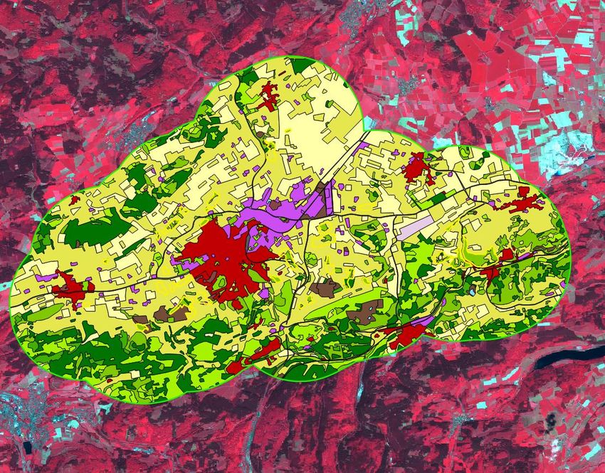
Copernicus Land Monitoring Service (CLMS):Übersicht
Land
Monitoring • Copernicus Dienst zur Überwachung der Landoberfläche wird von der
Europäischer Umweltagentur (EEA) und dem JRC (Global Component)
implementiert.
• Alle Produkte sind als ”view service” und download auf
https://land.copernicus.eu/ verfügbar.
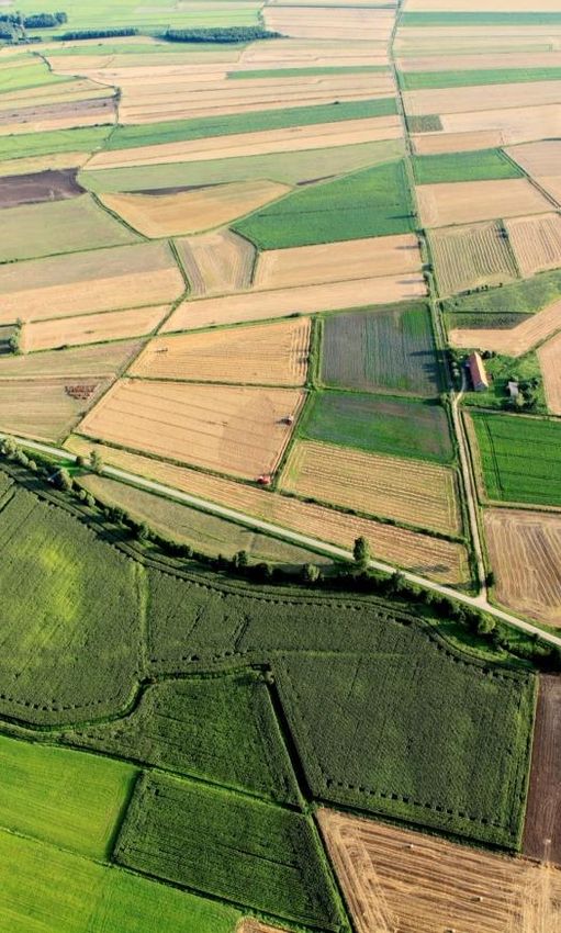
© Markus Probeck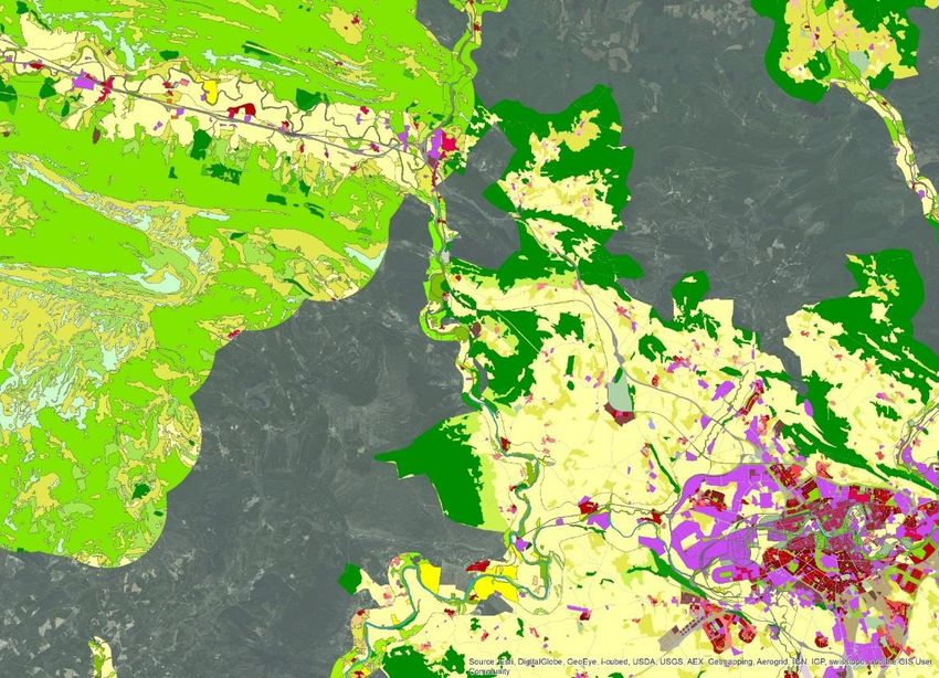
Copernicus Land Monitoring Service (CLMS). Produkt-Typen
  Land
Monitoring
                                     Systematic Biophysical Monitoring

                                     Land Cover & Land Use mapping

                                     Thematic hotspot mapping

                                     Reference data

                                     Ground Motion service               © Markus Probeck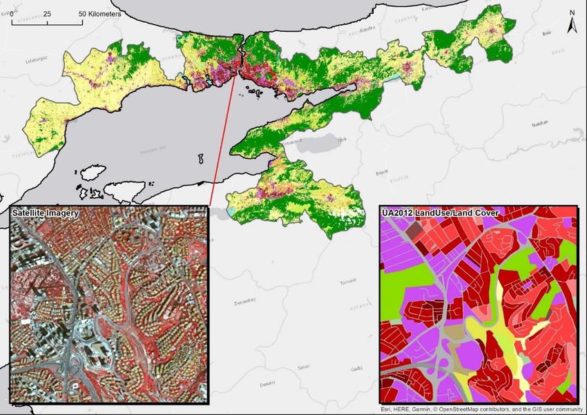
CLMS Produkte – operationell (grün) und geplant (rot)
  Land
Monitoring
CLMS portfolio on-line
  Land
Monitoring
Copernicus Landdienst: Produkt-Beispiele: “Land Cover and Land Use mapping”
  Land                                                                         2015 High
Monitoring
                                                                               Resolution
                                                                               Layers
                                                                               (HRL)

                                                                                     © Markus Probeck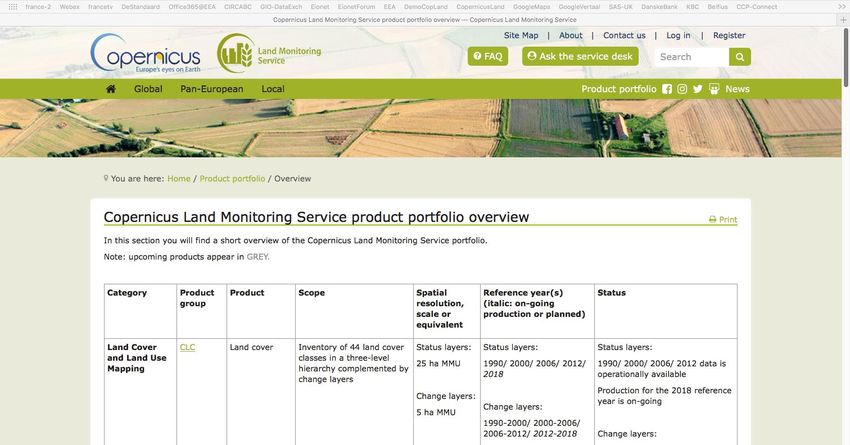
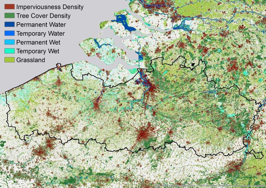
HRL Imperviousness (Flaechenversiegelung) Beispiel Berlin

                 2009-2012
                 2012-2015
                 2006-2009
                   2006
                   2015
  Land
Monitoring

                                                      NUTS-3 region
                                                      DE406
                                                      Dahme-Spreewald

             New Berlin-Brandenburg airport
             Construction start: September 2006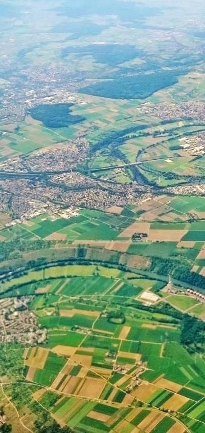
Copernicus Landdienst: Produkt-Beispiele: “Thematic hotspot mapping”
  Land
Monitoring

      UA                RZ          N2K
   2006-12-18         2012-18     2006-12
                                                                                    © Markus Probeck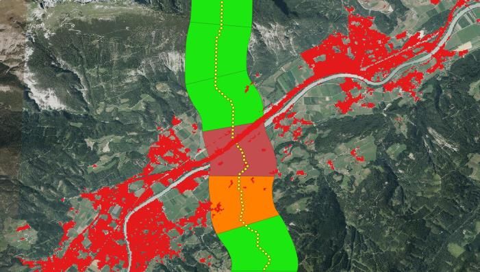
Copernicus Landdienst: Produkt-Beispiele: “Thematic hotspot mapping” N2K
  Land        N2k product (Land Cover status 2012)
Monitoring

                                                                                    Abbildung
                                                                                    von

             Germany, DE4617303 Kalkkuppen bei Brilon incl. 2km Buffer Zone
Neue Entwicklungen: Höhere Ansprüche und entsprechende CLMS Trends
Ansprüche
  Land                                       CLMS neue Entwicklungen und Trends
Monitoring
Kontinuität, Qualität, und Übertragbarkeit   •   sich fortsetzender Trend zu Zeitreihenanalyse und synergistischer Nutzung von
der Produkte und Zeitreihen                      Radar und Optischen Daten.
                                             •   Bessere Dokumentation von metadaten und ”expert products”
                                             •   Bessere Dokumentation von Methoden, Workflows und Tools (wenn möglich
                                                 open source)
                                             •   Verification einiger Produkte durch Länder
                                             •   Kooperation mit relevanten H2020 Projekten
Kürzere update cycles und schnellere         Verkürzung der Produktionszeit (z.B. für HRL’s und CLC2018) und Intervalle (aber
Produktion                                   Abhängig vom Produkt und der Thematik)
Höhere räumliche Auflösung der Produkte      Hotspot Produkte (Vector) basierend auf VHR Daten. Für High Resolution Layers
                                             (HRL): von 20m zu 10m pixel size. Verbesserte VHR2018 coverage und erste
                                             Kontinentale Produkte basierend auf VHR Daten (SWF Small Woody Features)
Von Landnutzung/Landbedeckung zu             Exporation von ersten Produkten die zusaetzlich Nutzungsintensität erfassen
Nutzungsintensität                           (Zusatzprodukt zu Grassland 2018 in Planung)

Neue policy Themen z.B. Urban Agenda,        Neue Produkte in Planung (Snow&Ice, Coastal Zone, Europäischer
Greening the CAP, Sustainable Development    Bodenbewegungsdienst, HR Phenology, CLC+);
Goals (SDG), LULUCF Regulation,              Enrichment von bestehenden Produkten durch EIONET
Biodiversity Strategy, und Anregung von
Ländern
Weiterentwicklung bestehender Produkte: Thematic hotspot mapping (local component)
Land
Monitoring • UA (Urban Atlas):
– Finished:
• Increase coverage from EEA32 to EEA39 countries
• 2018 update and 2012-2018 change and street tree layer
• 3rd dimension (capital downtown areas, 2012). Planned further extension
• RZ (Riparian Zones)
– Finished:
• Increase coverage to include Strahler level 2 (2-8)
• Extend temporal coverage to 12-18 change and 2018 status
• N2K (Natura 2000)
– 2006 and 2012 exists, update 2018 reference year planned for 2019
12Weiterentwicklung bestehender Produkte: LC/LU mapping (pan-European)
Land
Monitoring
• 2018 HRL’s: Produktionsstart Januar 2019
– Zunächst 4 Produktgruppen: imperviousness, tree cover (forest),
grassland und wetness & water
– Neu 2018: Imperviousness Produkt enthält eine “built up”
Komponente nach JRC (European Settlement Map) Methode (in
Zusammenarbeit mit dem JRC)
– Mögliche Zusatzprodukte für HRL forest (additional forest stand
information) und HRL grassland (use intensity) werden Diskutiert
– HRL Small Woody Features (SWF) 2015 noch in Produktion (diverse
Verzögerungen), deshalb Produktion von SWF (2018) erst ab Mitte
2019.Produkte in Planung (Teil 1 von 2)
Land
Monitoring Snow and ice
• Publication of tender Q4-2018, implementation start Q1-2019
Snow & Ice
• Ramp-up phase (approximately 6 months) – the Service will be defined
• Initial production phase (until end of 2020) – starting with FSC, gradual
enlargement of the product portfolio
High Resolution Phenology products with two main products:
• Seasonal trajectories: The reconstructed vegetation index time-series, HR Phenology
which are input to the phenology detection. e.g. daily, 10-day, monthly,
and yearly upon user’s request.
• Phenology parameters: Dates and values at Start of Season (SOS), End
of Season (EOS) and seasonal maximum, length of the growing season
(LOS), amplitude, base value, and seasonal integral values.
CZ 2018
Coastal Zone
• Coastal Zone: reference year 2018. CfT published. Start in 2019. © Markus ProbeckProdukte in Planung (Teil 2 von 2)
Land CLC+
Monitoring
• CLC+ ist eine Weiterentwicklung von Corine Landcover die stufenweise und zunächst
parallel zu dem traditionellen CLC implementiert wird
• CfT für ersten Implementierungs-Schritt (CLC-backbone) in Vorbereitung
European Ground Motion Service
• “The service will be consistent, standardized, interoperable, and harmonized
across national borders supporting European and national level policies”
• Ergänzt nationale Initiativen (z.B. den Deutschen Bodenbewegungsdienst)
• Service definition phase und supporting services (Advisory Board und Consultant at
EEA): Start etwa April 2019
© Markus ProbeckAnwendungsbeispiele für Produkte aus CLMS
Land • Europäische Anwendungen:
Monitoring – EEA Reports und indicators
– European SDG indicators (EUROSTAT)
– Support evaluation of common agriculture policy (CAP)
• Nationale/Regionale Anwendungen
– Monitoring von Versiegelung und “urban sprawl” (DG REGIO, aber auch Versicherungswirtschaft u.a.)
– Eingangsdaten in Modellierungen (z.B. “radioactive emission dispersion risk” oder Ausbreitung von
Aedes Albopictus (Tiger Mosquito)
– 5G Network Planning
– Monitoring von Verbuschung/Verwaldung von Alpinem Grasland
– Analyse von Konnektivitiät und LandschaftszerschneidungEEA & ETC/ULS selected reports based (partly) on
Copernicus Land Monitoring data
Land
Monitoring • Land cover changes and soil functions. An
approach for integrated accounting ETC/ULS Report
02/2018
• Tourism and the environment. Towards a reporting
mechanism in Europe. ETC/ULS Report 01/2018
• Landscapes in transition. An account of 25 years of
land cover change in Europe. EEA Report
No.10/2017.
• Similarities and diversity of European cities. A
typology tool to support urban sustainability.
ETC/ULS Report 03/2018
• Land recycling in Europe. Approaches to measuring
extent and impacts. EEA Report No.31/2016.
• Urban sprawl in Europe EEA/FOEN joint Report,
11/2016 – w. ETC ULS
• Mapping and assessing the condition of Europe’s
ecosystems: progress and challenges. EEA
contribution to the implementation of the EU
Biodiversity Strategy to 2020. EEA Report No.
3/2016E x i s t i n g a n dExamples
p l a n n e d –E Epublished
A i n d i c a t…o rand
s b ains ework
d on Copernicus
data
Land
Monitoring • Land take (based on CLC)
• Following Corine Land Cover updates, every 6 years – last update in 2017 based on
2012 data
• Imperviousness and imperviousness change
• (existing for 2009-2012, update for 2006-209-2012-2015 in preparation)
• Urban sprawl ‘indicator’ (developed and published, but not implemented)
• Land recycling and densification (published July 2018)
• Based on Corine LC and Urban Atlas LC change flows 2006-2012
• Set of 13 (sub)indicators
• Landscape fragmentation pressure from urban and transport
infrastructure expansion (published 2018)
• Based on HRL Imperviousness 2012 with corresponding OSM transport networks
• Forest indicator(s) (in preparation 2018/2019)
• Partly based on Copernicus forest products
• Peri-urban areas (in preparation)
• Grassland (in preparation)Dynamik von Versiegelungs und Bevökerungsdichte Analyse (© GeoVille Austria)
Land
Monitoring SOIL SEALING: A REGIONS’ RACE
EC Urban-rural
NUTS-3 typology
Size of bubble:
GDP PPP
(Eurostat)
© and Data analysis by GeoVille
Animation created with GapMinderDynamik von Versiegelungs und Bevökerungsdichte Analyse (© GeoVille Austria)
Land
Monitoring
EC Urban-rural NUTS-3
Many rural regions with continued typology
% change 2006-2015 (1 = 100%)
decoupling of soil sealing from
population growth
Size of bubble:
GDP PPP (Eurostat)
Most larger urban areas slowly tend
to stabilise, but overall sealing
rates still significant
© and Data analysis by GeoVille
% change 2006-2015 (1 = 100%) Eurostat)Fazit
Land
Monitoring • Nutzung der Produkte des Landdienstes zur Zeit überwiegend auf
Europäischer Ebene, aber zunehmend auch Nationale/Regionale
Nutzungsbeispiele
• Anregung die Produkte kreativ und in Synergie mit bestehenden Daten
einzusetzen und zu erproben
• Trend: verstaerkte Zusammenarbeit der Copernicus Dienste (Land,
Atmosphere, Marine, CC, Emergency)
• Seit 25 Jahren bestehende enge Verbindungen von EEA mit den
Laendern (EIONET) als Grundlage fuer Weiterentwicklung des Dienstes
• Hintergrund für Weiterentwicklung des Landdienstes sind neue
Europäische Monitoring Aufgaben (LULUCF, greening the CAP etc), und
Anregungen aus den Ländern
© Markus ProbeckAnwendungsbeispiele und feedback für Produkte aus CLMS
Land • Mehr Beispiele: https://land.copernicus.eu/user-corner/land-use-cases
Monitoring
• Sie haben ein Anwendungsbeispiel, Anregungen, Fragen oder Vorschläge?: bitte
Details und feedback an copernicus.land@eea.europa.eu (gerne auch auf Deutsch)Sie können auch lesen