Investigation of layered gabbroic intrusions, Bergslagen - Dick Claeson & Daniel Sopher Bergslagen, etapp 2
←
→
Transkription von Seiteninhalten
Wenn Ihr Browser die Seite nicht korrekt rendert, bitte, lesen Sie den Inhalt der Seite unten
Bergslagen, etapp 2

Investigation of layered gabbroic
intrusions, Bergslagen
Dick Claeson & Daniel Sopher        mars 2021

SGU-rapport 2021:18
Cover photo: Layered gabbroic rock at Pappas kullar, the Flinten intrusion (6723543/554218).
Photographer: Dick Claeson.

Author: Dick Claeson, Daniel Sopher
Reviewed by: Magnus Ripa, Johan Jönberger
Head of unit: Ildikó Antal Lundin
Editor: Lina Rönnåsen
Geological Survey of Sweden
Box 670, 751 28 Uppsala, Sweden
phone: 018-17 90 00
e-mail: sgu@sgu.se
www.sgu.se
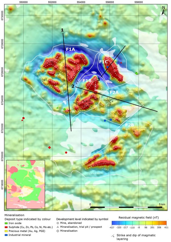
TABLE OF CONTENTS
Sammanfattning ............................................................................................................................................ 4
Abstract .......................................................................................................................................................... 6
Introduction .................................................................................................................................................. 7
Geological field work ................................................................................................................................... 9
    The Flinten intrusion............................................................................................................................... 9
    The Fullen, Skållberget and Furulund intrusions close to Hofors ................................................. 14
    Sulphide mines at Kuså and Gaddebo ................................................................................................ 20
Geophysical work ....................................................................................................................................... 22
    Petrophysical measurements ................................................................................................................ 25
        Petrophysical measurements from the Flinten intrusion ............................................................ 25
        Petrophysical measurements from the Fullen intrusion .............................................................. 30
    Airborne geophysical measurements and gravity data ..................................................................... 35
        The Flinten intrusion ........................................................................................................................ 37
        The Fullen intrusion ......................................................................................................................... 43
    Ground based measurement ................................................................................................................ 47
        Detailed ground magnetic measurements at the Flinten intrusion ............................................ 47
        Detailed ground magnetic measurements at the Fullen intrusion ............................................. 50
    Geophysical modelling .......................................................................................................................... 53
        Method for 2D modelling ................................................................................................................ 53
        2D modelling results from Flinten ................................................................................................. 54
        2D modelling results from Fullen ................................................................................................... 66
        Method and 3D modelling results from Flinten ........................................................................... 76
    Discussion and summary of geophysical work.................................................................................. 79
Lithogeochemistry ...................................................................................................................................... 81
    Method .................................................................................................................................................... 81
    The Flinten intrusion............................................................................................................................. 81
    The Fullen, Skållberget and Furulund intrusions close to Hofors ................................................. 85
    Sulphide mines at Kuså, Gaddebo and Brunnsjöberget .................................................................. 90
        External lithogeochemical data for the sulphide mines at Kuså and Gaddebo ....................... 94
Discussion and conclusions ...................................................................................................................... 95
References ................................................................................................................................................... 97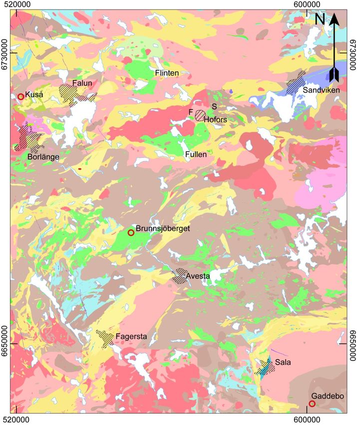
SAMMANFATTNING
Projektet Bergslagen, etapp 2 – regional ingår i SGUs systematiska geologiska undersökningar av
prospekteringsintressanta områden, där delprojektet Basiska intrusioner ingår (se www.sgu.se
under Mineralnäring/Mineralinformation/Kartering i Bergslagen).
Bergslagen är en av Sveriges viktigaste malmprovinser där gruvdrift har pågått i mer än 1 000 år.
Utöver att vara en region med många järn-, basmetall- och ädelmetallfyndigheter, har Bergslagen
också potential för innovationskritiska metaller och mineral. Behovet av metaller och mineral
ökar och har aldrig varit större än vad det är idag. Inom EU finns ett särskilt intresse för så
kallade ”kritiska material” som bland annat behövs i grön teknik som elbilar, batterier, vind-
kraftverk och solceller. Även efterfrågan på andra metaller ökar. Klimatförändringar och energi-
omställningen utgör en utmaning för råvaruförsörjningen.
I samband med SGUs undersökningar av berggrunden i Ludvikaområdet så konstaterades kraftigt
förhöjda halter av innovationskritiska metaller inom platinagruppen (PGE) i mineraliseringen i en
äldre nickel- och koppargruva vid Brunnsjöberget, Hedemora (Claeson m.fl. 2018, 2019). Förekomst
av basmetaller är av avgörande betydelse för att man ska kunna få ekonomi för en eventuell brytning
av de mer sällsynta metallerna. Sedan tidigare var det känt att man vid intrusionen Flinten funnit
anomala halter PGE i lokala block men inte i fast klyft (Filén m.fl. 1989, Filén 1990).
Mot denna bakgrund beslutades om en mindre insats för att studera några förekomster av basiska
intrusioner och analysera berggrunden med hjälp av geofysik och litogeokemi samt utföra fält-
uppföljningar inom Bergslagen. Ytterligare förekomster i äldre gruvområden har besökts och
genom litogeokemisk provtagning analyserats med avseende på ett stort antal grundämnen.
Syftet med projektet är att uppdatera de lokala berggrundsgeologiska och geofysiska databaserna, vilka
kan utgöra planerings- och resurshushållningsunderlag för prospekteringsföretag, kommuner och
länsstyrelser med flera i Bergslagen. Databaserna från projektet kommer att omfatta kartor, häll-
observationer, litogeokemi, mineralfyndigheter, petrofysiska egenskaper och geofysiska mark-
mätningar. Projektarbetet startade i början på året 2019 och avslutas i början av 2021.
Sommaren och hösten 2019 utfördes geologiska och geofysiska fältundersökningar vid den lagrade
basiska intrusionen Flinten, samt litogeokemisk provtagning vid gruvor i gabbroida bergarter vid
Kuså och Gaddebo. Under november–december 2019 gjordes flyggeofysiska TEM-mätningar med
helikopter över Flinten med omgivning. Under en vecka i maj 2020 genomfördes geologiska och
geofysiska fältundersökningar vid den lagrade basiska intrusionen Fullen och två närliggande basiska
kroppar vid Furulund och Skållberget i trakterna av Hofors. Petrofysiska mätningar på delar av de
insamlade bergarterna utfördes vid SGUs laboratorium under 2019 och 2020.
Denna rapport redovisar huvudsakligen nytillkommen information från fältsäsongen 2019 och
2020, modellering från de markgeofysiska mätningarna, petrofysiska mätningar, de helikopter-
burna TEM-mätningarna och litogeokemiska analysresultat.
De basiska intrusionerna i Bergslagen visar lovande potential för att både basmetaller, som till
exempel nickel och koppar, tillsammans med PGE kan förekomma i ekonomiskt signifikanta
koncentrationer. Det är dock inte mycket känt om omfattningen av mineraliseringar eller
extraherbarheten för vissa mineral eller grundämnen i dessa. Trots att ingen gruvdrift av PGE har
skett i Bergslagenregionen visar denna studie att det finns potential, både i större lagrade intrusioner
och i sulfidgruvor med nickel och koppar i Bergslagen. De kända Ni-Cu-sulfidgruvorna finns ofta i
mindre, gabbroiska kroppar och uppvisar således ingen uppenbar relation till större lagrade
intrusioner. Dock är geometrin för dessa magmatiska system fortfarande okänd och därför är det
okänt om de kan ha någon koppling till större magmatiska kroppar på större djup i krustan.

4     SGU-RAPPORT 2021:18
Inom denna studie har geometrin för den magmatiska lagringen inom både Flinten- och Fullen-
intrusionerna tolkats, baserat främst på data från magnetfältet som uppmätts med flyg och
observationer vid hällblottningar. Dessutom har de magmatiska bergartslagrens magnetiska
egenskaper modellerats i två dimensioner och i fallet med Flinten-intrusionen även i 3-
dimensioner. Magnetiska mätningar gjorda över ett litet fokusområde vid Fullen-intrusionen visar
utmärkt korrelation mellan de magnetiska anomaliernas orientering och magmatisk lagring i
hällarna, vilket ger ett gott stöd för tolkningarna. Vid Flinten-intrusionen visar observationerna
och de magnetiska mätningarna från ett litet fokusområde ett mer komplext förhållande. Detta
indikerar att även om lagringsgeometrin som tolkas från de flygmätta data vid Flinten sannolikt är
representativ i stor skala, kan den ha en mer komplex geometri när man studerar i en mindre
skala. Karaktäriseringen av lagringen av dessa intrusioner, om än i stor skala, kan vara användbar
information för framtida geofysiska och geologiska undersökningar. Till exempel tillhandahåller
de ett verktyg för att förutsäga orienteringen av eventuella potentiella sulfidmineraliseringar i
form av lager, vilka kan associeras med till exempel PGE och andra ädla metaller. Detta kan även
vara användbart för att utforma och optimera framtida undersökningsmetoder, såsom
markbaserade elektromagnetiska mätningar.
Baserat på de luftburna och markbaserade elektromagnetiska mätningarna som presenteras i
denna rapport har flera zoner med lägre resistivitetsvärden än deras omgivningar markerats. I
vissa fall verkar dessa zoner ligga nästan parallellt med den tolkade riktningen för den magmatiska
lagringen. Sådana områden kan vara av intresse för vidare utredning.
En tolkning av Flinten-intrusionens struktur presenteras i denna studie, baserat på den observerade
lagringens riktning, luftburna magnetiska mätningar och gravitationsdata. I denna tolkning är
intrusionen uppdelad i fem regioner, vilka tolkas representera enskilda delintrusioner. Baserat på deras
geofysiska egenskaper kan dessa regioner ordnas i två grupper (tre norra regioner och två södra
regioner), där delintrusionerna inom varje grupp tolkas som mer eller mindre samtida. Två- och
tredimensionell modellering av gravitation och magnetiska data stöder denna tolkning. Denna
karakterisering kan vara intressant att utforska vidare, eftersom den kan indikera systematiska
skillnader i kemi och fysikaliska egenskaper inom de olika delarna av Flinten-intrusionen. Det är dock
viktigt att notera att innan en sådan tolkning kan underbyggas bättre skulle mycket mer data, till
exempel litogeokemiska och petrofysiska prover, behöva samlas in och analyseras.
Ytterligare undersökningar av de basiska intrusionerna inom Bergslagen kan bestå av omfattande
markgeofysiska mätningar, omfattande litogeokemiska provtagningar och analyser, bestämning av
mineraler och deras sammansättning, textur, strukturgeologi och när en potentiell sulfidmineralisering
lokaliseras även kärnborrning. Sådana undersökningar utfördes dock inte som en del av detta projekt
på grund av kostnader och tidsbegränsningar.
Den finansiella kostnaden för denna första bedömning av den ekonomiska potentialen för
lagrade intrusioner i Bergslagenregionen har varit relativt låg. Trots detta har metoderna och
tillvägagångssättet som tillämpats i denna studie visat sig vara effektiva för att karakterisera
strukturen, de kemiska och fysiska egenskaperna hos de undersökta intrusionerna och skulle
därför vara bra att använda i framtida undersökningar av basiska intrusioner, inom Sverige eller
någon annanstans. Denna studie ger också ett exempel på vad som kan uppnås när omfattande
data från SGUs befintliga databaser utnyttjas tillsammans med nya data, från relativt småskaliga
men fokuserade markbaserade undersökningar.
Lägesbestämningar har gjorts i koordinatsystemet Sweref 99 TM.
Uppdatering av SGUs databaser (malmkemi, bergartskemi, geofysiska data) sker kontinuerligt allt
eftersom resultat från nya analyser och mätresultat kommer in från SGUs Bergslagsprojekt.

                                                                                  SGU-RAPPORT 2021:18   5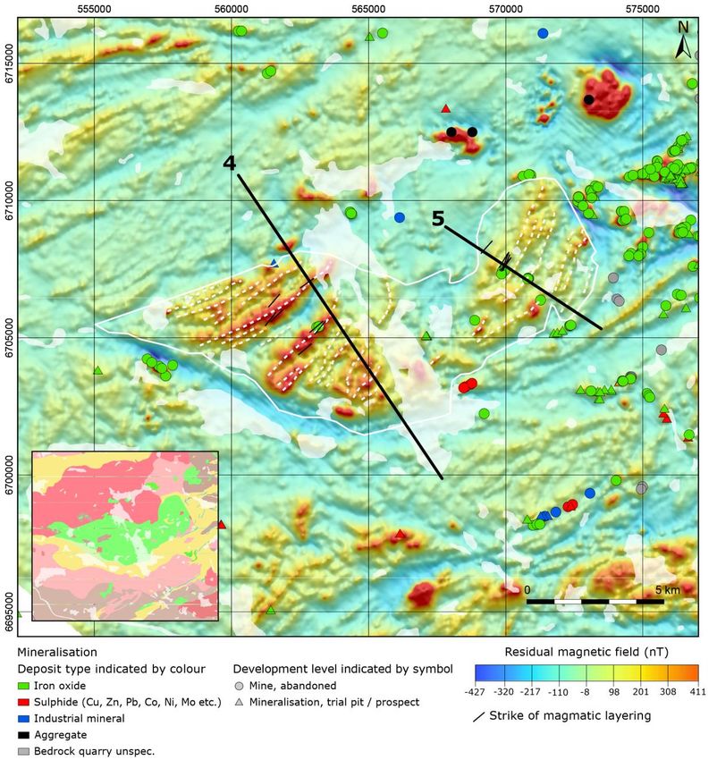
ABSTRACT
Presently, global demand for innovation-critical metals, such as PGEs, is high and continues to
grow. The Geological Survey of Sweden (SGU) has conducted a study to investigate the potential
for PGE as well as base metal deposits in basic intrusions within the Bergslagen region, Sweden.
The study focuses on the Flinten and Fullen intrusions but also addresses a series of abandoned
mines within other basic intrusions, such as the Kuså gruvor and Gaddebo gruvor.
As part of this study, new field investigations were performed during 2019 and 2020, which
included geological observations, collection of petrophysical and lithogeochemical samples and
outcrop measurements of natural gamma radiation and magnetic susceptibility. Furthermore,
magnetic field and VLF measurements were collected along a series of profiles. New airborne
geophysical data collected over the Flinten and Fullen intrusions as well as gravity measurements
are also included in the study. These data have been processed, interpreted, and modelled in 2-
and 3-dimensions to characterise the structure, properties, and geochemistry of the different
intrusions.
The study shows promising indications that both base metals and PGEs occur in economic
concentrations within the basic intrusions within the Bergslagen region. A clear relationship
between the anomalies in the airborne magnetic field data and magmatic layering observed at
outcrop appears to exist. Hence, the large-scale geometry of the layering in the Flinten and Fullen
intrusions has been interpreted. Based on the data in this study the Flinten intrusion is interpreted
to consist of several sub-intrusions. Based on the airborne and ground-based geophysical data,
several regions with low resistivity, which lie subparallel to the interpreted magmatic layering have
been identified at the Fullen and Flinten intrusions, which could be interesting for further
investigation.

6     SGU-RAPPORT 2021:18
INTRODUCTION
The “Basic intrusions” sub-project is included within the Bergslagen project (stage 2 – regional),
which forms part of SGU's systematic geological investigation of areas of interest for exploration
(see www.sgu.se at Mineral resources/Geological information for mineral exploration/Mapping
in Bergslagen).
The Bergslagen region is one of Sweden's most important ore provinces where mining has been
performed for more than 1 000 years. As well as being rich in iron, base metal, and precious
metal deposits, the Bergslagen region also has the potential to host innovation-critical metal and
mineral deposits. The global demand for these resources has never been higher than it is today
and is likely to increase in the future. Within the EU, there is a special interest in the so-called
“critical materials” that are needed in green technology such as electric cars, batteries, wind
turbines and solar cells. Presently, one of the important challenges for the innovations required to
address climate change and to provide alternative energy solutions for society is the supply of raw
materials.
In connection with SGU's investigations of the bedrock in the Ludvika area, elevated contents of
innovation-critical metals within the platinum group elements (PGE) were found in an old nickel
and copper mine at Brunnsjöberget, Hedemora (Claeson et al. 2018, 2019). Furthermore,
previous prospecting efforts at the Flinten intrusion identified anomalous levels of PGEs, albeit
within local boulders of basic intrusive rock (i.e. not sampled from outcrop) (Filén et al. 1989,
Filén 1990). In addition, a better understanding of the potential for base metal deposits within
basic intrusions in the Bergslagen region is required. As the presence of base metals in association
with rarer metals (important for green technology), can be an important factor in making the
extraction of these rarer metals economically viable.
In the light of the above, it was decided that a small effort would be made to perform a focused
study of the Flinten and Fullen intrusions within the Bergslagen region. This would include
geophysical and lithogeochemical measurements, as well as geological field observations (fig. 1).
Minor sampling for lithogeochemical analysis of additional deposits and abandoned mines, within
basic intrusions elsewhere within the Bergslagen region, was also part of the project.
The purpose of the project is to update the geological and geophysical databases within and
around these basic intrusions. These data can be valuable for planning and resource management,
for exploration companies, municipalities, county administrative boards and other parties
interested in the Bergslagen region. The databases from the project will include maps, rock
observations, lithogeochemical data, data from mineral deposits, petrophysical data, and ground-
based geophysical measurements. The project work started at the beginning of the year 2019 and
will end in early 2021.
All position information within the study is provided in the Sweref 99 TM coordinate system.
SGU's databases (including bedrock observations, lithogeochemical and geophysical databases)
are updated continuously as new results become available from SGU's Bergslagen project.

                                                                               SGU-RAPPORT 2021:18   7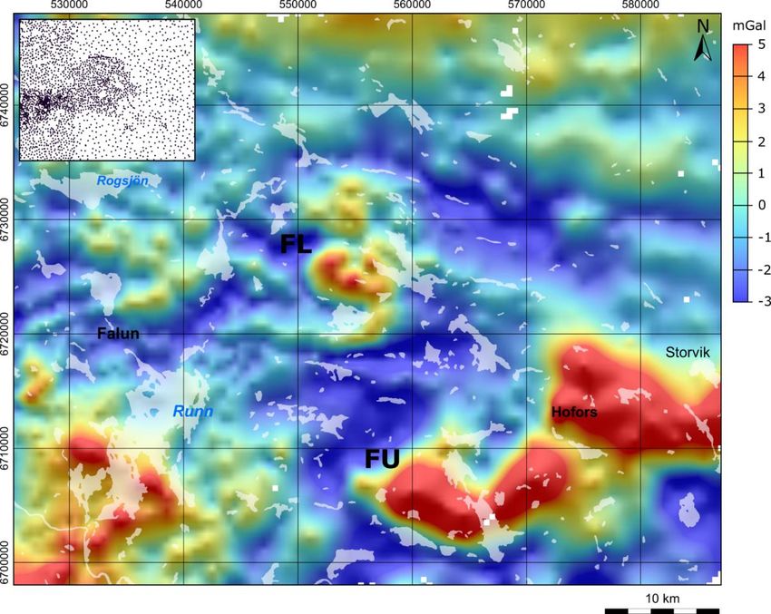
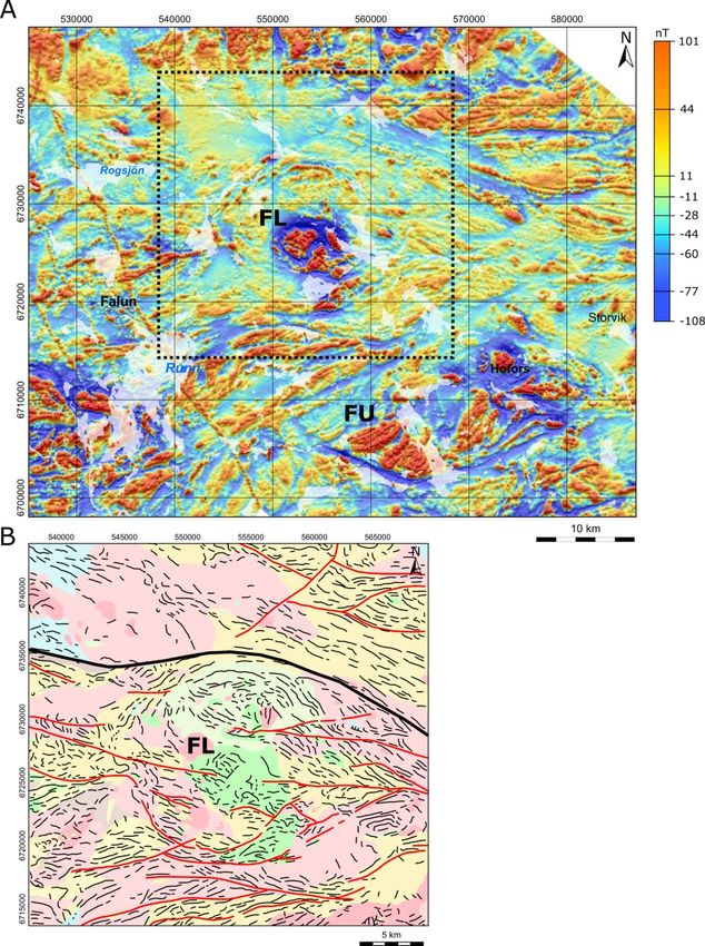
20 km

Figure 1. Geological map of the central-northern part of the Bergslagen region, which includes the basic intrusions
investigated in this study (simplified from SGU’s database). Most rocks are metamorphic except for the youngest. The
locations of the Flinten and Fullen intrusions are shown. Red circles indicate the position of sulphide mines within basic
intrusions, which were sampled for geochemical analysis. The two intrusions, close to the town of Hofors, labelled with
letters F and S show the locations of the Furulund and Skållberget intrusions, respectively.

8      SGU-RAPPORT 2021:18
GEOLOGICAL FIELD WORK
The Flinten intrusion
The Flinten intrusion has been the subject of earlier investigations and exploration efforts of
various kinds (e.g. Hammergren 1982, Filén et al. 1989, Lindholm 1990). It is a layered basic
intrusion with more or less well-developed modal layering (fig. 2A–B). Cumulate rocks are clearly
observable at most of the outcrops visited, however, it is not always possible to discern layering
or structures related to magmatic segregation and fractionation. Ultramafic to leucogabbroic
layers with different proportions of dark and light-coloured minerals, constitute the
macroscopically observable forms of layering. At some of the visited outcrops, light-coloured
cumulates of troctolite are present, a rock dominated by plagioclase and olivine with minor
pyroxene and amphibole. In the cumulate layers, more diffuse aggregates of light-coloured
minerals are sometimes seen in darker layers. These could be interpreted as regions of late
crystallised magma, forming mainly within layers dominated by dark-coloured minerals as a post-
cumulus product. However, the aggregates can also appear in adjacent layers, indicating that fluid
phases moved around within the cumulate rocks before the intrusion completely solidified
(fig. 2C). Cumulates of gabbro pegmatite to coarse-grained gabbro with cm-sized crystals also
occur at some outcrops (fig. 2D). In general, however, the rocks are medium-grained to coarse-
grained at the outcrops which were investigated. At some outcrops, large variations in the
composition of the cumulate rocks are seen, varying from anorthosite to leucogabbro, to gabbro
and to ultramafic cumulates Here they can appear partly as layers and partly with more chaotic
geometries. These different varieties can sometimes coexist, often displaying coarse-grained
portions (fig. 2E–H).
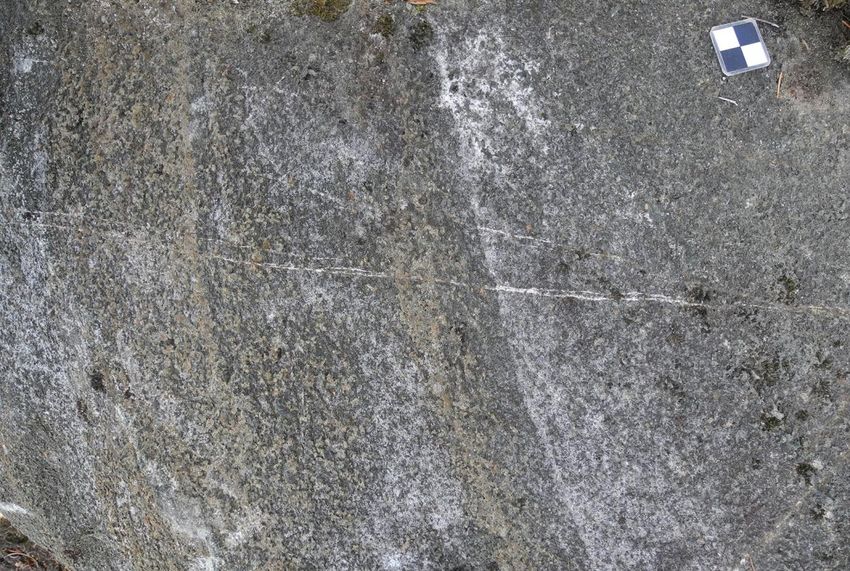
A B
Figure 2. Obvious modal layering. A. Small-scale repetition of layers with different mineral compositions, often centimetre
wide (6723758/555933). B. Several decimetre wide cumulate layers with different proportions of light- and dark-coloured
minerals respectively (6723608/554213). Photos: Dick Claeson.
SGU-RAPPORT 2021:18 9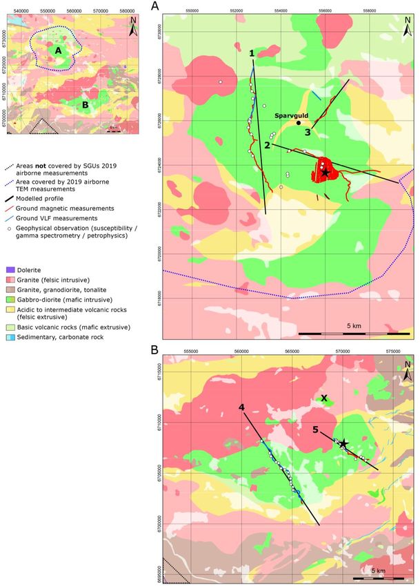
C                                                             D

  E                                                             F

  G                                                             H

Figure 2 continued. C. Cumulate layer with diffuse accumulations of light-coloured minerals in relation to the darker,
pockets of late crystallised magma, mainly within the layer, but also seen in the adjacent layer (6723581/554446).
D. Cumulate of gabbro pegmatite to coarse-grained gabbro (6723898/555826). A large variation in compositions (E–H),
from anorthosite, over leucogabbro and gabbro to ultramafic cumulates, where they appear partly as layers and partly
more chaotic with different varieties alternating, often with coarse-grained parts. E. Leucogabbro and ultramafic cumulates.
F. Close-up of coarse-grained leucogabbro. G. Coarse-grained ultramafic cumulate with portions of anorthosite. H. Close-up
of anorthosite in ultramafic cumulate (E–H images at 6723997/555808). Photos: Dick Claeson.

10      SGU-RAPPORT 2021:18
A                                                             B

  C                                                             D

Figure 3. A. Biotite oikocryst-bearing ultramafic cumulate at Vargberget östra (6723231/552845). B. Pyrrhotite in fractures
of ultramafic cumulate at Vargberget västra (6723454/552390). C. Thin sulphide mineralised portions, possibly fracture-
fillings, D. close-up of C. (6723794/554310). Photos: Dick Claeson.

There are two known mineralised parts of the Flinten intrusion where some mining activity has
occurred, a closed mine called Vargberget östra and a prospecting pit called Vargberget västra.
The rocks at Vargberget östra consist typically of an ultramafic cumulate with minor gabbroic
cumulate rocks. Here biotite occurs as oikocrysts (several cm in size) and the rock surface has
cavities due to the preferential weathering of these oikocrysts (fig. 3A). This is the only sampled
rock at Flinten that had any anomalous concentrations of PGE and it is an early-formed
cumulate without obvious crystals of sulphide minerals (see sample 9 in section Lithogeochemistry).
Vargberget västra on the other hand has pyrrhotite within both gabbroic and ultramafic parts and
is a late-formed cumulate (fig. 3B, see sample 10 in section Lithogeochemistry). Other observations
of sulphide minerals, apart from within boulders, were thin, sulphide mineralised portions,
possibly fracture-fillings, at a few outcrops (fig. 3C–D). Such an occurrence in a melanocratic
gabbro was sampled and analysed. The results showed elevated concentrations of Cu, Ni, and Co
but not elements of the platinum group (see sample 14 section Lithogeochemistry).

                                                                                                 SGU-RAPPORT 2021:18      11
A B Figure 4. Different behaviour of trondhjemite at Flinten. A. Ductile and with contacts indicating that they are comagmatic (6723543/554218). B. A brittle appearance with fracture-fillings and parts of the cumulate as fragments (6723608/554213). Photos: Dick Claeson. Trondhjemite is seen as almost white areas at outcrops and as wide fracture-fillings at several sites (fig. 4A). The trondhjemite is most likely comagmatic with the gabbro in which it occurs. These rocks are late derivatives formed by fractional crystallisation and accumulation of the basic magma, which are subsequently distributed within fracture systems within the previously formed cumulate gabbroic rocks. The fractures which the trondhjemite has filled, most likely formed at a time when the cumulates were to a large extent rigid. The cumulates were then ruptured due to movements within the magma chamber or due to contraction during solidification of the intrusion (fig. 4B). In parts of the intrusion, fragments of what appears to be previously solidified mafic magma can be observed. These fragments probably formed and solidified within a large (primary) magma chamber and were later broken up and transported in connection with movement of magma through supply channels (fig. 5A). At other outcrops, it is difficult to determine whether these fragments are fine-grained parts of consanguine gabbroid rocks or xenoliths (probably volcanic) unrelated to the intrusion (fig. 5B). At some outcrops classic magma mingling and mixing structures can be observed. Here fragments with very different appearances can be seen, however, they are interpreted here to all originate from the same mafic magma source (fig. 5C–D). 12 SGU-RAPPORT 2021:18
A                                                           B

 C                                                           D

Figure 5. A. Fragments that likely formed and solidified within the main magma chamber, which have subsequently been
broken up, B. close-up of gabbroid fragment with fine-grained basic fragment (images at 6724267/554180). Fragments with
classic magma mingling and mixing structures, very different appearance but probably all components derived from the
mafic magma, C. round contacts, with ocelli of plagioclase, D. angular and round contacts of dark fragments (images at
6725424/553676). Photos: Dick Claeson.

Deformation can be seen at some outcrops, that may be of a regional nature, but overall, the
layered sequences are intact and not characterised by any extensive deformation. Most of the
minor deformation which can be observed in outcrop is probably related to contraction during
the final phase of the solidification process within the magma chamber. However, the presence
of small local brittle and ductile deformation zones is also likely. This is consistent with the
interpretation of the regional magnetic field data (see section Geophysical work, fig. 24), which
suggests that the level of deformation within the mafic rocks of the Flinten intrusion is relatively
low, when compared to the surrounding area. Alteration is noted at some outcrops within the
intrusion, occurring mainly in amphibole and plagioclase-bearing cumulates. In these cases, the
appearance of the rocks which have undergone alteration provides a strong contrast to that of
unaltered rocks. Here, the primary minerals, mostly black pyroxene and olivine, are replaced with
greenish amphibole. The altered rocks are deformed in some places (fig. 6A). However, it is not
known whether these features are related to the initial magmatic and cooling event or to later
metamorphic overprinting. Perhaps the most notable deformation zone within the intrusion, is
present to the north of Sparvguldsberget and has a northeast to southwest direction. This
deformation zone can clearly be observed in the apparent resistivity map of the Flinten intrusion
(see section Geophysical work, marked with an X in fig. 26). Based on observations from outcrops
and from the Sparvguld borehole, located at 6725901/554780, this deformation affects dioritoid
to gabbroid rocks (fig. 6B) and skarn-bearing metavolcanic rocks present in this area
(Hammergren 1982).
                                                                                             SGU-RAPPORT 2021:18     13
A B Figure 6. A. Altered and deformed cumulate rock (6723885/555980). Photo: Dick Claeson. B. Deformed dioritoid to monzogabbro in deformation zone (6725352/553594). Photo: Daniel Sopher. The samples analysed for lithogeochemical composition show a large variation, which is interpreted to be related to magmatic differentiation and the formation of cumulates in a large magma chamber (see section Lithogeochemistry). Based on work from this study, it is interpreted that the Flinten intrusion consists of several magma chambers and that the intrusion is formed by at least three relatively independent parts present at the surface. These independent parts are likely to be fed from a common magma chamber, positioned lower in the crust (see section Geophysical work, specifically figs. 25 and 49). Exactly how these parts were formed, in what order, and if differences in the magma that fed these parts exists, are questions which require greater resources than were available for this study. The Fullen, Skållberget and Furulund intrusions close to Hofors The Fullen intrusion has been the target of various investigations and exploration efforts in the past (e.g. Filén et al. 1988, Filén 1990). It is a layered, basic intrusion which often exhibits well- developed modal layering (fig. 7A–B). Cumulate rocks are clear characteristics of most of the outcrops visited, however, it is not always possible to discern layering or structures related to magmatic segregation and fractionation. At some locations cumulates can range from leucocratic, to melanocratic and ultramafic over a single outcrop, representing modal variations of light- coloured and dark minerals (fig. 7C–E). In some cases, the layering is associated with changes in the grain-size distribution (fig. 7F). The contrast between different layers can sometimes be conspicuous, relating to changes in colour, grain size, or modal composition (fig. 7G–I). Contacts between different layers can be razor sharp or more gradual (fig. 7C, G). Often all or several of the above layering structures were present at the outcrops which were investigated. Conversely, in rare cases no signs of layering were present, where the texture of the rock exhibited a massive appearance, in some cases over the entire outcrop (fig. 7J). Regions of relatively high and low magnetic susceptibility could also be measured at a given outcrop, which in some cases, could be correlated with visible indications of layering. 14 SGU-RAPPORT 2021:18
A                                                           B

  C                                                           D

  E                                                           F

Figure 7. A. Well-developed modal layering resulting in alternating gabbro and melagabbro to ultramafic cumulates
(6705360/563131). B. Layering in terms of different compositions and grain size (6705833/561615). C. Layering as modal
variations of light-coloured and dark minerals (6705360/563131). D. Layering of leucocratic and melanocratic gabbro
(6704609/562635). E. Layering of gabbro and ultramafic cumulates (6704609/562635). F. Variable grain-size distribution
resulting in layering (6705833/561615). Photos: Dick Claeson.

                                                                                              SGU-RAPPORT 2021:18        15
G H I J Figure 7 continued. G. Razor sharp contacts between different layers (6706968/562785). H. Conspicuous contrast between different layers (6705408/563185). I. Close-up of contact in H. J. Massive gabbro (6706050/570996). Photos: Dick Claeson. A few occurrences of rocks that are enclave-bearing were seen and may indicate that magma mingling between consanguineous batches occurred (fig. 8A). Note the lack of any features indicating a major difference in temperature, e.g. chilled margins, between the rocks and how the contacts are interfingering and lobate (fig. 8A). Amphibole-filled fractures were present almost orthogonal to the layering at some outcrops, probably formed during late crystallisation and contraction of the cumulates (fig. 8B). Some outcrops have gabbro with distinct parts which contain plagioclase phenocrysts (fig. 8C). Pegmatite gabbro is observed over large areas as well as in small portions or pockets of late-stage crystallisation in cumulates (fig. 8D–E). Trondhjemite was seen at a few outcrops as fracture-filling (fig. 9A–B). This type of rock is most likely comagmatic with the gabbro within which they occur, formed by fractional crystallisation of the basic magma and later injected into the fracture systems within the cumulates. At some outcrops xenoliths of rhyolite are seen and these are clearly older rocks than the gabbro they occur in at the Fullen intrusion (fig. 9C). 16 SGU-RAPPORT 2021:18
A                                                            B

  C                                                            D

  E

Figure 8. A. Enclave-bearing cumulate indicates magma mingling, note absence of chilled margins and the interfingering
and lobate contacts (6705408/563185). B. Amphibole-filled fractures almost orthogonal to layering (6705408/563185).
C. Plagioclase porphyric gabbro (6706968/562785). D. Pegmatite gabbro from a layer (6706365/559244). E. Pocket of
pegmatite gabbro formed during late-stage crystallisation in cumulate (6705833/561615). Photos: Dick Claeson.

                                                                                               SGU-RAPPORT 2021:18       17
A B C Figure 9. A. Trondhjemite is seen in few outcrops as fracture-fillings, B. close-up (images at 6705644/568847). Photos: Dick Claeson. C. Xenolith of rhyolite in layered gabbro cumulate (6707680/570040). Photo: Daniel Sopher. Two intrusions, located to the east (Skållberget) and west (Furulund) of Hofors, respectively, were visited and a single sample was collected from each intrusion (fig. 1). The intrusion at Skållberget shows layering features (fig. 10A). The sampled ultrabasic cumulate has in places weak dissemination of pyrrhotite and chalcopyrite (fig. 10B). The intrusion at Furulund consists mostly of ultramafic cumulates, where a major portion of the rocks are altered and now have serpentine instead of olivine in their groundmass (fig. 10E). If plagioclase is present at all in these rocks, it occurs as an interstitial, late-crystallising mineral (fig. 10D). Layering is present but not easily detected on all surfaces (fig. 10C). The Karlsborg mine, which was quarried between 1962 and 1974 (Wik et al. 2009, fig. 10F), is located within the Furulund intrusion. Today the Karlsborg mine appears as a small, partly water-filled hole. 18 SGU-RAPPORT 2021:18
A                                                             B

  C                                                             D

  E                                                             F

Figure 10. A. The intrusion at Skållberget shows layering features (6713678/573892). B. An ultrabasic cumulate at
Skållberget, which has in places weak dissemination of pyrrhotite and chalcopyrite (6713678/573892). C. Layering is present
but not easily detected on all surfaces at the Karlsborg mine, Furulund (6712495/568024). D. If plagioclase is present at all
in the ultramafic cumulate, it occurs as an interstitial, late-crystallising mineral (6712495/568024). E. Altered ultramafic
cumulate at the Karlsborg mine, Furulund with serpentine replacing olivine (6712495/568024). F. Karlsborg mine, Furulund
(6712495/568024). Photos: Dick Claeson.

                                                                                                 SGU-RAPPORT 2021:18      19
Sulphide mines at Kuså and Gaddebo The nickel and copper mines at Kuså and Gaddebo were visited and sampled for lithogeochemical analysis in 2019. The Kuså mine and its surroundings have been described in several papers (e.g. Löfstrand 1903, Geijer 1917, Kulling & Hjelmqvist 1948, Grip 1961, Magnusson 1973, Nilsson 1985, Ripa et al. 2017). The Kuså mine includes three smaller mines which were visited in this study, these were the Kuså gruva 2 mine, the Muttogruvan 2 mine and the Illingsbergsgruvan mine. The waste rock at the Kuså gruva 2 mine consists of gabbroic rocks and large amounts of sulphide minerals (fig. 11A). The sulphide minerals which were identified were chalcopyrite, pyrrhotite, and pyrite. Occasionally, “skillersten” and oikocrysts of amphibole in gabbroid to hornbländite were present. The mineral sperrylite (PtAs2) has been reported from the Kuså mine (Zakrzewski 1989). At the Muttogruvan 2 mine, there were significantly smaller amounts of sulphide-rich waste rock when compared to the Kuså gruva 2 mine, which contained chalcopyrite and pyrrhotite (fig. 11B). The waste rock was mixed with gabbroid. The third mine in the Kuså area, the Illingsbergsgruvan, had sulphide-rich gabbroid among the waste rock (fig. 11C). The sulphide minerals consist mainly of chalcopyrite, pyrrhotite, and single crystals of covellite. Irregular occurrence of “skillersten” and centimetre-sized oikocrysts of amphibole were noted in the gabbro rocks. The Gaddebo mines were in production between 1870–1871 and subsequently several investigations have been carried out (e.g. Löfstrand 1903, Grip 1961, Wik et al. 2006). At the Gaddebo mines, the waste rock consists of gabbroid with sulphide-rich parts (fig. 11D–E). The sulphide minerals chalcopyrite and pyrrhotite occur as lumps or as aggregates. However, these minerals can also be disseminated within the gabbroid (fig. 11D–E). 20 SGU-RAPPORT 2021:18
A B
C D
E
Figure 11. A. Waste rock at Kuså gruva 2 of gabbroic rocks with sulphide minerals (6717698/521472). B. Gabbroid at
Muttogruvan 2 with chalcopyrite and pyrrhotite (6717501/521587). C. Sulphide-rich gabbroid in waste rock from
Illingsbergsgruvan (6717451/521806). D. The waste rock at Gaddebo gruvor consists of gabbroid with sulphide-rich parts
(6633246/601595). E. The most common sulphide minerals are chalcopyrite and pyrrhotite, both as aggregates and
disseminated (6633246/601595). Photos: Dick Claeson.
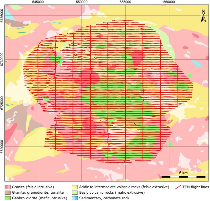
SGU-RAPPORT 2021:18 21GEOPHYSICAL WORK The physical properties of mafic intrusions often contrast significantly with the physical properties of the surrounding rocks. As well as this, strong contrasts in physical properties can also occur in association with the internal structure of mafic intrusions. Hence, geophysical methods can be a useful tool when investigating layered mafic-ultramafic intrusions as well as the potential for associated mineralisation. There are numerous examples of other studies which have used geophysical methods to investigate layered intrusions. McEnroe et al. (2009) performed a detailed investigation of the magnetic properties of the Bjerkreim-Sokndal norite, layered intrusion in Norway. Here the complex magnetic pattern observed from airborne and ground magnetic data is attributed to variations in the magnetic minerals within the different layers. The pattern is complicated by cycles of magma recharge, which alter the composition of the magma chamber over time. Ferré et al. (2009) show examples of how the magnetic properties vary through layers within several mafic-ultramafic intrusions from Africa. In this study, differentiation within the magma chamber combined with magma recharge is also invoked as the mechanism for altering the amount of magnetic minerals within different layers of the intrusions. Ferré et al. (2009) identify magnetite as the most important magnetic mineral within their case studies, however they note that pyrrhotite in association with other sulphide minerals can also be important for the magnetic response. Maes et al. (2007) use anisotropy of magnetic susceptibility (AMS) measurements to gain insight into the formation of a stratabound zone enriched in Au and PGE, within the Sonju Lake layered intrusion, USA. Finn et al. (2015) use a range of geophysical methods including magnetotellurics (MT), gravity, and magnetics to generate models to characterize the South African Bushveld layered mafic intrusion in 3D. Ferris et al. (1998) used 2D modelling to investigate the structure of the Dufek intrusion in Antarctica, based on aeromagnetic data. PGE deposits, which can occur within layered mafic intrusions, often have physical properties which contrast to the surrounding mafic rocks. Electrical resistivity is an important example of such a property. As PGE deposits often occur in association with sulphide minerals, they can have far lower electrical resistivity values than the surrounding mafic rocks (King 2007, Finn et al. 2013). Previous geophysical investigations have been carried out at the Flinten intrusion, which included acquisition and interpretation of ground VLF (very low frequency) and magnetic data, interpretation of airborne data and collection of petrophysical samples (Granar & Henkel 1981). Many of these investigations were focused on a region with anomalously low resistivity. Based partially on these results, the Sparvguld borehole (shown in figure 12) was drilled to investigate this anomaly (Hammergren 1982). However, no sulphide mineralisation was encountered and instead a water-bearing deformation zone was intersected, within a sequence of predominantly felsic rocks. As part of the project, additional geophysical data were collected from the Flinten and Fullen intrusions during the summers of 2019 and 2020 (fig. 12). This included geophysical observations which were made at outcrops. These observations included magnetic susceptibility measurements (at least 8 measurements for each rock type present at a given outcrop), acquisition of 51 petro- physical samples and 19 measurements of natural gamma radiation (at 8 unique locations). Furthermore, several ground-based profiles were collected at the two sites including 16 profiles were the magnetic field was measured and six profiles were the electrical conductivity was measured using the VLF method. In addition, new measurements collected by SGU within the Bergslagen area in association with other projects between 2019 and 2020 were utilised in this study. This included new airborne measurements of the magnetic field and natural gamma radiation. Electrical conductivity was also measured using the VLF method (dual transmitters). In the late autumn of 2019 airborne transient electromagnetic (ATEM) measurements were also 22 SGU-RAPPORT 2021:18
performed over the Flinten intrusion and surrounding area. Furthermore, additional gravity
measurements were made at the Flinten intrusion.
The objectives of the geophysical investigations within this project were as follows:
• To increase the amount of geophysical and petrophysical data available for these two
intrusions in SGU’s databases.
• To perform an assessment of the petrophysical properties of these two intrusions.
• To improve the understanding of the large-scale structure and geometry of these intrusions.
• To gain a better understanding of the internal structure of these intrusions, specifically, the
magmatic layering.
• To highlight any indications of mineralisation based on the geophysical data.
To address these objectives within this study, the available petrophysical data as well as the newly
acquired airborne and gravity data are presented, discussed, and interpreted. Furthermore, 2D
and 3D geophysical modelling of the Fullen and Flinten intrusions are also presented and
discussed.
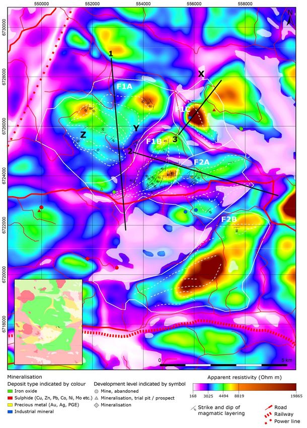
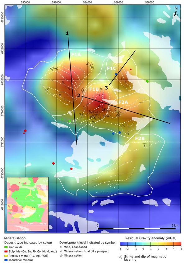
SGU-RAPPORT 2021:18 23Figure 12. Maps detailing the two intrusions where geophysical investigations were performed. The small map in the top left corner shows a large-scale map detailing the relative position of the two mafic intrusions shown in more detail in A. and B. The location of new ground-based data acquired within the project as well as the 2D profiles which are modelled are shown on the maps. A. Map of the Flinten intrusion. B. Map of the Fullen intrusion. The X denotes the location of the abandoned Karlsborg mine, within the Furulund intrusion, where serpentinised ultramafic rocks occur. The black stars in A. and B. denote the location where 2D ground magnetic measurements were conducted. The location of the Sparvguld borehole is labelled in A. 24 SGU-RAPPORT 2021:18
Petrophysical measurements
Before attempting to interpret the geophysical data, it is important to develop an understanding
of the physical properties of the different rock types which occur in the vicinity of the two
intrusions. In this section, a statistical analysis of the newly acquired and pre-existing petro-
physical data is presented and discussed.

Petrophysical measurements from the Flinten intrusion
Figure 13 describes the locations of the available petrophysical data for the Flinten intrusion and
defines the area considered in the petrophysical analysis. Here it can be observed that, within the
central area of the Flinten intrusion (approximately at coordinates 6725000/555000), that there
are relatively large amounts of petrophysical data available. However, within the intrusive mafic
rocks outside of the central area there are far fewer petrophysical samples available. Similarly,
there are relatively few petrophysical samples available for the felsic extrusive and intrusive rocks
in the surrounding area. In contrast to the petrophysical measurements, there are relatively large
amounts of outcrop magnetic susceptibility measurements in the surrounding felsic rocks. The
extrusive mafic rocks to the north of the Flinten intrusion are poorly sampled, when compared to
the other rock types in the study area.

Figure 13. Map detailing the data used in the Flinten petrophysical analysis. The red dots indicate where magnetic
susceptibility has been measured at outcrop, while the blue dots indicate locations where petrophysical samples have been
acquired. See figure 12 for the legend for the bedrock geology map.

                                                                                               SGU-RAPPORT 2021:18     25
Figure 14. Histograms showing the distribution of density (left) measured on petrophysical samples and magnetic susceptibility (right) measured on petrophysical samples and at outcrop, for four different rock types in the Flinten area. A. Graphs for extrusive felsic rocks. B. Graphs for intrusive felsic rocks. C. Graphs for intrusive mafic rocks. D. Graphs for extrusive mafic rocks. Figure 14 shows histograms describing the distributions of density and magnetic susceptibility for the four major rock types in the Flinten study area. Figure 15 shows cross plots of density and magnetic susceptibility for the same groups. Summary statistics for these groups can also be found in table 1. Here it can be observed that the felsic extrusive and felsic intrusive rocks have average densities of 2 670 and 2 660 kg/m3, respectively. 26 SGU-RAPPORT 2021:18
Table 1. Summary statistics for the petrophysical data from the Flinten study area. The upper part of the table (with blue
striped shading) shows the statistics for all available data, from the four major rock types considered. The lower part of the
table (with green striped shading) provides statistics for more detailed classifications of mafic intrusive rocks. Note that only
samples collected during this project are included in these more detailed classifications.

 Rock Type             Density (kg/m3)                Susceptibility (10-6 SI)                     Q
                       Samples     Mean   Std. dev.   Samples      Min           Max      Median   Samples   Min    Max       Median
 Felsic extrusive      11          2670   36          231          10            50000    200      11        0.07   2         0.13
 Felsic intrusive      14          2660   37          364          30            80000    490      11        0.04   7.04      0.10
 Mafic intrusive       53          3020   107         283          150           387000   1580     51        0.04   91.3      0.63
 Mafic extrusive       3           2960   8           50           200           20000    600      1         0.77   0.77      0.77
 Diorite-Gabbro        2           2770   17          2            440           483      461      2         1.06   1.24      1.15
 Troctolite            2           2830   13          2            1160          1470     1310     2         2.78   6.76      4.77
 Gabbro                10          3030   57          10           640           138000   18200    10        0.12   91.3      1.64
 Gabbro-Ultramafic     3           3170   154         3            127000        387000   131000   3         0.05   2.92      0.39
 Ultramafic            1           3180   NA          1            156000        156000   156000   1         0.04   0.04      0.04

Figure 15. Cross plots showing the density and magnetic susceptibility values for petrophysical samples from four different
rock types from the Flinten area. In each graph the coloured dots indicate the data from a specific rock type, while the grey
dots show all the available petrophysical data for the Flinten area. A. Graph for extrusive felsic rocks. B. Graph for intrusive
mafic rocks. C. Graph for intrusive felsic rocks. D. Graph for extrusive mafic rocks.

The extrusive and intrusive mafic rocks have far higher average densities of 2 960 and 3 020 kg/m3,
respectively. With regards to the magnetic properties of the felsic rocks, both intrusive and extrusive
rock types have a peak susceptibility value at 100 × 10-6 SI, which is most likely due to the presence of
iron-bearing paramagnetic minerals. The susceptibility distribution for intrusive felsic rocks (granite;
and to a lesser extent extrusive felsic rocks) has a second peak value at approximately 3 000 × 10-6 SI.
This could be due to the presence of a significant proportion of biotite in some cases but could also
be due to the presence of small amounts of magnetic minerals. The average magnetic susceptibility
values of the extrusive and intrusive mafic rocks are higher than the felsic rocks. For both mafic rock
types, a peak susceptibility value can be observed at approximately 1 000 × 10-6 SI, which most likely
represents significant quantities of iron-bearing paramagnetic minerals. A significant proportion of the

                                                                                                        SGU-RAPPORT 2021:18       27
susceptibility values for the intrusive mafic rocks lie above 10 000 × 10-6 SI, which is most likely due to the presence of magnetic minerals. Figure 16 shows a cross plot of magnetic susceptibility and density for intrusive mafic rocks from the Flinten study area. Here the data are subdivided to investigate the properties of the different types of intrusive mafic rocks. Summary statistics for these data can also be found in table 1. It can be observed that the samples classified as diorite-gabbro and troctolite have relatively low- density values. This is most likely due to the larger proportion of feldspar, and in the case of diorite-gabbro, potentially small quantities of quartz. A general increase in density is observed as the amount of feldspar in the different rock types decreases (e.g. from troctolite to gabbro and finally ultramafic). With these samples, a general increase in magnetic susceptibility is also observed, moving from the more feldspar-rich rock types (e.g. diorite-gabbro and troctolite) to the gabbro and ultramafic rocks. This is most likely due an overall increase in iron-bearing paramagnetic minerals and magnetic minerals. As part of the petrophysical analysis the remnant magnetisation of the different rock types was investigated. Figure 17 shows cross plots of the Q value and remanent magnetisation (J) versus magnetic susceptibility. The Q value describes the ratio between the remanent and induced components of the magnetisation, where a Q value above 1 indicates that the remnant component of the overall magnetisation is greater than the induced component. Here it can be observed that remanent magnetisation is significant for the intrusive mafic rocks from the Flinten study area, where a significant proportion of the samples exhibit a Q value above 1. An approximately linear trend also appears to exist between remanent magnetisation and magnetic susceptibility (fig. 17). Remnant magnetisation for the other rock types considered in this study are also shown in figure 17 (as grey dots). The Q values in these rock types are typically not above 1. Figure 17 also shows a rose diagram of the azimuth of the remanent magnetisation for intrusive mafic rocks from the Flinten study area. The dominant azimuth for the remanent magnetisation is north-northeast. Inclination values (not shown here) for the remanent magnetisation are also typically above 50º. Hence it appears that in most cases, the remanent magnetisation has a similar orientation to the Earth’s current magnetic field. Figure 16. Cross plot showing the density and magnetic susceptibility values for petrophysical samples for intrusive mafic rocks from the Flinten intrusion. Only values for petrophysical data collected during this project are shown. The data are grouped into five different categories, which are represented with different symbols and colours. 28 SGU-RAPPORT 2021:18
Figure 17. Graphs describing the remanent magnetisation of intrusive mafic rocks from the Flinten intrusion. A. A cross plot
showing the Q value versus the magnetic susceptibility. B. A cross plot showing the remanent magnetisation (J) versus the
magnetic susceptibility. In both A and B, data from intrusive mafic rocks are shown as black dots. Data from the other rock
types in the study area are shown as grey dots. C. A rose diagram showing the azimuth of the remanent magnetisation for
intrusive mafic rocks.

                                                                                                 SGU-RAPPORT 2021:18      29
Petrophysical measurements from the Fullen intrusion As part of this study a petrophysical analysis was also carried out for the Fullen intrusion and surrounding area. Figure 18 shows the available data which was considered in the petrophysical analysis as well as the area over which the data was collected. Figure 20 shows histograms of the available density and magnetic susceptibility data from the Fullen study area. Figure 19 shows cross plots of magnetic susceptibility versus density for the Fullen petrophysical data. Table 2 shows summary statistics for the four different rock type classifications used in figures 19 and 20. In general, the density and magnetic susceptibility distributions for the Fullen intrusion are similar to those from the Flinten intrusion. Here felsic extrusive and intrusive rocks have an average density of 2 640 kg/m3, while mafic extrusive and intrusive rocks have average densities of 3 000 and 2 970 kg/m3, respectively. The distributions of magnetic susceptibility are also similar to those observed in the Flinten intrusion. However, in contrast to the data from the Flinten area, the felsic extrusive and intrusive rocks appear to have a larger proportion of samples with a relatively high susceptibility value. Hence in the Fullen data the second maximum on the histogram (at approximately 3 000 × 10-6 SI) is larger than in the Flinten data. Similarly, the average magnetic susceptibility values of the mafic rocks are also higher for the Fullen intrusion when compared to the Flinten intrusion. This difference in magnetic susceptibility values between the Flinten and Fullen study areas is also reflected in the summary values in table 2. A number of samples from the mafic intrusive rocks from the Fullen area have anomalously low densities, which are highlighted in figures 19 and 20. These samples were collected from the abandoned Karlsborg mine, within the Furulund intrusion, west of the town of Hofors (fig. 10F). In this area ultramafic rocks occur which have been serpentinised (see figure 12 for location), hence the overall density of these ultramafic rocks has been reduced due to the alteration process (hydration). Figure 18. Map detailing the data used in the Fullen petrophysical analysis. The red dots indicate where magnetic susceptibility has been measured at outcrop, while the blue dots indicate locations where petrophysical samples have been acquired. See figure 12 for the legend for the bedrock geology map. 30 SGU-RAPPORT 2021:18
Table 2. Summary statistics for the petrophysical data from the Fullen study area. The upper part of the table (with blue
striped shading) shows the statistics for all available data, from the four major rock types considered. The lower part of the
table (with green striped shading) provides statistics for more detailed classifications of mafic intrusive rocks. Note that only
samples collected during this project are included in these more detailed classifications.

 Rock Type           Density (kg/m3)                Susceptibility (10-6 SI)                     Q
                     Samples Mean       Std. dev.   Samples Min                Max      Median   Samples      Min     Max    Median
 Felsic extrusive    9          2640    29          196         48             500000   400      6            0.06    8.81   1.23
 Felsic intrusive    34         2640    51          723         10             80000    2000     28           0.03    12.5   0.23
 Mafic intrusive     84         2970    77          605         10             700000   8000     80           0.02    186    0.40
 Mafic extrusive     1          3000    NA          64          200            400000   600      1            0.77    0.77   0.77
 Leucogabbro         1          2800    NA          1           728            728      728      1            2.35    2.35   2.35
 Gabbro              20         3010    60          20          611            196000   38200    20           0.02    19.1   0.34
 Gabbro-Ultramafic   1          3040    NA          1           34900          34900    34900    1            0.13    0.13   0.13
 Ultramafic          1          2760    NA          1           189000         189000   189000   1            1.24    1.24   1.24

Figure 19. Cross plots showing the density and magnetic susceptibility values for petrophysical samples from four different
rock types from the Fullen area. In each graph the coloured dots indicate the data from a specific rock type, while the grey
dots show all the available petrophysical data for the Fullen area. A. Graph for extrusive felsic rocks. B. Graph for intrusive
mafic rocks. C. Graph for intrusive felsic rocks. D. Graph for extrusive mafic rocks.

Figure 21 shows a cross plot of magnetic susceptibility and density for petrophysical samples
from the Fullen study area, subdivided into different types of intrusive mafic rocks. Summary
statistics for these data can also be found in table 2. A single sample collected from a rock type
classified as leucogabbro exhibits a relatively low density and magnetic susceptibility when
compared to the other rock types. This is most likely due to the relatively large amounts of
feldspar present within this sample. The majority of the samples are from gabbro. Here a bimodal
distribution in magnetic susceptibility can be observed (as in figs. 19 and 20). The higher
susceptibility values (of approximately 100 000 × 10-6 SI) likely reflect layers of gabbro which
contain appreciable amounts of magnetic minerals (such as magnetite). A single sample of
ultramafic rock taken from the Karlsborg mine (within the Furulund intrusion) exhibits a
relatively high magnetic susceptibility but low density, due to serpentinisation.

                                                                                                           SGU-RAPPORT 2021:18    31
Sie können auch lesen