RV ALKOR Fahrtbericht / Cruise Report AL533 - Helmholtz-Zentrum ...
←
→
Transkription von Seiteninhalten
Wenn Ihr Browser die Seite nicht korrekt rendert, bitte, lesen Sie den Inhalt der Seite unten
RV ALKOR Fahrtbericht /
                  Cruise Report AL533
GEOMAR REPORT

                Mutual Field Trials of the Manned Submersible JAGO
                      and the Hover-AUVs ANTON and LUISE
                    off the Aeolian Islands, Mediterranean Sea

                  Catania (Italy) – La Seyne-sur-mer (France)
                              05.02. – 18.02.2020

                           Berichte aus dem GEOMAR
                   Helmholtz-Zentrum für Ozeanforschung Kiel

                               Nr. 55 (N. Ser.)
                                    May 2020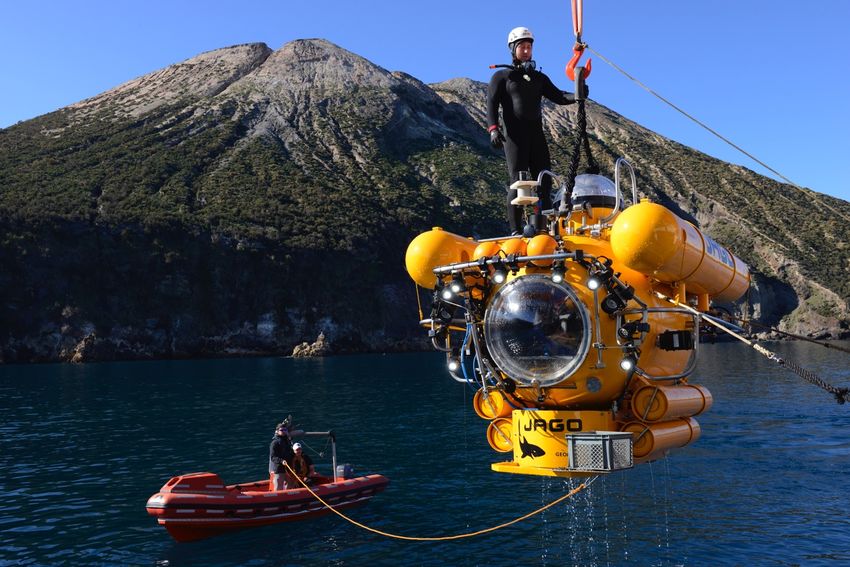
RV ALKOR Fahrtbericht /
  Cruise Report AL533
Mutual Field Trials of the Manned Submersible JAGO
      and the Hover-AUVs ANTON and LUISE
    off the Aeolian Islands, Mediterranean Sea

  Catania (Italy) – La Seyne-sur-mer (France)
              05.02. – 18.02.2020

          Berichte aus dem GEOMAR
  Helmholtz-Zentrum für Ozeanforschung Kiel

               Nr. 55 (N. Ser.)
                    May 2020
Das GEOMAR Helmholtz-Zentrum für Ozeanforschung Kiel                 The GEOMAR Helmholtz Centre for Ocean Research Kiel
       ist Mitglied der Helmholtz-Gemeinschaft                            is a member of the Helmholtz Association of
           Deutscher Forschungszentren e.V.                                       German Research Centres

Autoren/Authors:
Karen Hissmann, Marcel Rothenbeck, Emanuell Wenzlaff, Tim Weiß, Patrick Leibold

GEOMAR Report
ISSN Nr.. 2193-8113, DOI 10.3289/GEOMAR_REP_NS_55_2020

Helmholtz-Zentrum für Ozeanforschung Kiel / Helmholtz Centre for Ocean Research Kiel
GEOMAR
Dienstgebäude Westufer / West Shore Building
Düsternbrooker Weg 20
D-24105 Kiel
Germany

Helmholtz-Zentrum für Ozeanforschung Kiel / Helmholtz Centre for Ocean Research Kiel
GEOMAR
Dienstgebäude Ostufer / East Shore Building
Wischhofstr. 1-3
D-24148 Kiel
Germany

Tel.: +49 431 600-0
Fax: +49 431 600-2805
www.geomar.de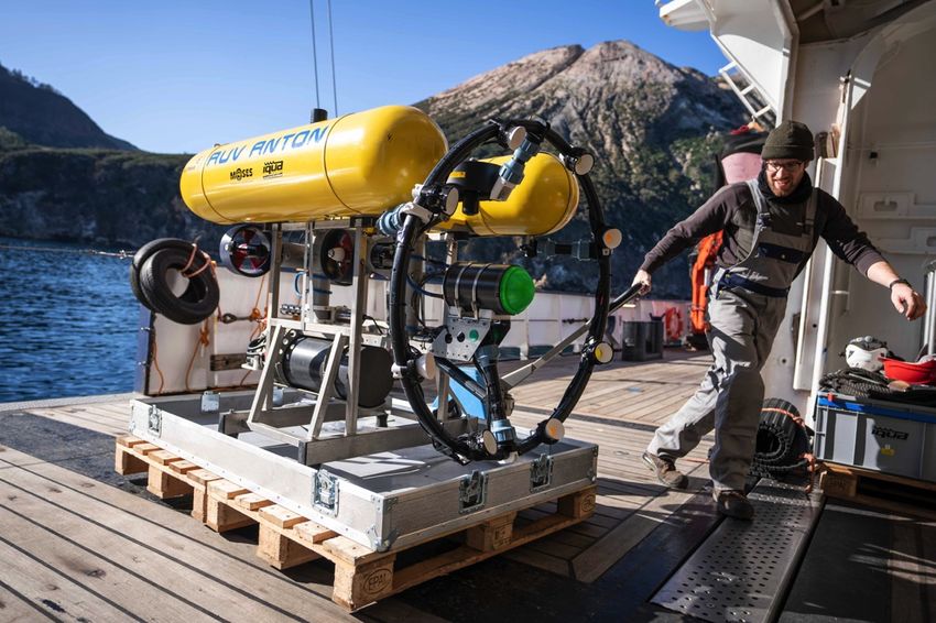
2                 ALKOR-Berichte, AL 533, Catania – La Seyne-sur-mer, 5 Feb. – 18 Feb. 2020

Table of Contents
1     Cruise Summary ..................................................................................................................3
      1.1     Summary in English ................................................................................................3
      1.2     Zusammenfassung ...................................................................................................3
2     Participants ..........................................................................................................................5
      2.1     Scientific Party ........................................................................................................5
      2.2     Participating Institutions .........................................................................................5
3     Research Program ...............................................................................................................5
      3.1     Aims and Agenda of the Cruise ..............................................................................5
      3.2     Description of the Working Area ............................................................................7
4     Narrative of the Cruise ........................................................................................................8
5     Preliminary Results ...........................................................................................................11
      5.1     Dives with the manned submersible JAGO ..........................................................12
      5.1.1 Short system description .......................................................................................12
      5.1.2 Overview of the submersible dives and first results .............................................14
      5.2     Dives with the AUVs ANTON and LUISE ..........................................................16
      5.2.1 Short system description (AUVs, IQUAview, BELUGA) ...................................16
      5.2.2 Overview of the AUV missions performed during AL533 ...................................20
      5.2.3 Preliminary results and outsome of the AUV test missions ..................................23
      5.3     The Camera System CoraMo MK II and its use for imaging surveys ..................23
      5.4     EvoLogics USBL, network setup and comparison of software ............................27
      5.5     EvoLogics Seabed Transponders ..........................................................................30
      5.6     Multibeam Echo Sounder Imagenex 837B Delta T ..............................................35
      5.7     Collection of still-, video and 360°-footages for public outreach work…………38
      5.8     Geological surveys and samples ...........................................................................39
6     Station List AL533 ............................................................................................................39
      6.1     Overall Station List ...............................................................................................39
7     Data and Sample Storage and Availability .......................................................................40
8     Acknowledgements ...........................................................................................................40
9     References .........................................................................................................................41
10    Appendices ........................................................................................................................42
      10.1 Selected Pictures of Shipboard Operations ...........................................................42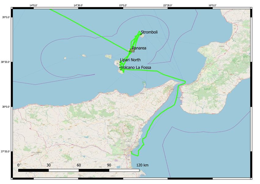
ALKOR-Berichte, AL 533, Catania – La Seyne-sur-mer, 5 Feb. – 18 Feb. 2020      3

1      Cruise Summary
1.1         Summary in English
The tight program of scientific research cruises usually does not leave enough time for thorough
tests of new research equipment and their system components, nor for extensive pilot and
handling training. For this reason, ship time was requested for sea trials of two types of
autonomous (not tethered) underwater vehicles owned by GEOMAR, the manned 400-meter
submersible JAGO and the Hover-AUVs ANTON and LUISE, type Girona500. The aim was to
test several technical and operational aspects with both vehicles at locations with differently
structured terrain (from flat ground to steep rocky slopes) and to water depths of up to 500
meters. The Aeolian Islands in the Tyrrhenian Sea north of Sicily were chosen as test area. The
volcanic islands offer sheltered sea conditions at their leeway, and bottom currents are usually
weak or absent. Rocky and steep slopes are located in short distances to areas with flat
underwater topography, providing ideal test conditions.
Dives took place from 07-15 Febuary in the Baia di Levante between Punta Roja and Punta
Luccia of Vulcano island (38°24.70’N, 14°58.56’E), off the east coast of Lipari Island
(38°26.45’N, 14°58.12’E and 38°30.05’N, 14°58.10’E), off Panarea island (38°38.62’N,
15°05.18’E and 38°37.43’N, 15°04.61’E) and off the Sciara del Fuoco, the northwest slope of
the active Stromboli volcano (38°48.19’N, 15°12.15’E). Seven dives were performed with the
manned submersible JAGO to train piloting, sampling and video-recording in steep terrain, to
establish transfer of USBL positioning data between the vessel and the submersible via modem,
to test rim thruster performance, and rescue buoy release. The dives were performed at bottom
depths between 50 and 310 meter. The Hover-AUVs ANTON and LUISE were deployed in total
11 times for 22 missions in water depth between 15-200 meter. Dives were used to test the
BELUGA network system for data exchange between different underwater vehicles and the new
camera system CoraMo for photographic surveys. At the last station on February 15, a
simultaneous dive of JAGO and AUV ANTON were performed during which both vehicles
made images of one another and were tracked simultaneously via USBL and BELUGA. Only
one out of nine days in the working area was lost for deployments due to strong winds. The
vessel docked in La Seyne-sur-mer / France on February 17, 2020.
The cruise was also used to gather material for public outreach work of GEOMAR. A
cameraman and a photographer documented all aspects of the work on board with still and 2D-
video cameras, with a 360°-camera for VR-viewing and 3D-projection and a drone for aerial
photography. Images of the sea floor and rock samples will be analysed by the Italian
volcanologist Dr. Daniele Casalbore of the University Sapienza in Rome who joined the cruise.

1.2         Zusammenfassung
Das enge Programm wissenschaftlicher Forschungsfahrten lässt in der Regel nicht genügend Zeit
für gründliche Tests neuer Forschungsgeräte und ihrer Systemkomponenten. Dies gilt auch für
ein umfangreiches Piloten- und Handling-Training. Aus diesem Grund wurde für zwei nicht
kabelgebundene Unterwasserfahrzeuge des GEOMAR, das bemannte Tauchboot JAGO und die
Hover-AUVs ANTON und LUISE, Typ Girona500, Schiffszeit beantragt und bewilligt, die
ausschließlich für Gerätetests und ein intensives Trainingsprogramm genutzt wurde, und zwar
4              ALKOR-Berichte, AL 533, Catania – La Seyne-sur-mer, 5 Feb. – 18 Feb. 2020

unter Bedingungen, die mit Forschungsausfahrten vergleichbar sind. Ziel war es, verschiedene
technische und operative Aspekte beider Fahrzeuge in unterschiedlich strukturiertem Gelände
(von flachem Boden bis zu steilen felsigen Hängen) und in Wassertiefen von bis zu 500 Metern
zu testen. Als Testgebiet wurden die Äolischen Inseln im Tyrrhenischen Meer nördlich von
Sizilien ausgewählt. Die Vulkaninseln bieten auf ihrer Leeseite windgeschützte Seebedingungen
und unter Wasser sind Grundströmungen schwach ausgeprägt. Felsige und steile Hänge liegen in
kurzer Entfernung zu Gebieten mit flacher Unterwassertopographie. All dies sind ideale
Testbedingungen.
        Die Tauchgänge fanden vom 07. bis 15. Februar in der Baia di Levante zwischen Punta
Roja und Punta Luccia vor der Insel Vulcano (38°24.70'N, 14°58.56'E), vor der Süd- und
Ostküste der Insel Lipari (38°26.45'N, 14°58.12'E und 38°30.05'N, 14°58.10'E), vor der Insel
Panarea (38°38.62'N, 15°05.18'E und 38°37.43'N, 15°04.61'E) und an der Sciara del Fuoco, dem
Nordwesthang des aktiven Vulkans Stromboli (38°48.19'N, 15°12.15'E) statt. Sieben
Tauchgänge wurden mit dem bemannten Tauchboot JAGO durchgeführt. Beim Piloten-Training
wurde u.a. Probenahme und Videoaufzeichnung in steilem Gelände trainieren. Während der
Tauchgänge wurde außerdem die Übertragung von USBL-Positionsdaten zwischen Schiff und
Tauchboot über ein Modem etabliert, die Leistung neuer Ringantriebe überprüft und das
Auslösen der Rettungsboje unter Seebedingungen getestet. Die Tauchgänge fanden in Tiefen
zwischen 50 und 310 Metern statt. Die Hover-AUVs ANTON und LUISE wurden insgesamt elf
Mal für 22 unterschiedliche Test-Missionen in Wassertiefen zwischen 15 und 200 Metern
eingesetzt. Bei den Tauchgängen wurde das neue BELUGA-Netzwerk zur Kommunikation und
zum Datenaustausch zwischen mehreren Unterwasserfahrzeugen getestet sowie das neue
Kamerasystem CoraMo für fotografische Surveys. An der letzten Station am 15. Februar wurde
ein gemeinsamer Tauchgang von JAGO und AUV ANTON durchgeführt, bei dem beide
Fahrzeuge unter Wasser Fotos und Videos voneinander machten und gleichzeitig über USBL
und BELUGA von Bord der ALKOR verfolgt wurden. Nur einer von insgesamt neun Tagen
Arbeitszeit vor Ort ging aufgrund starker Winde für Geräte-Einsätze verloren. Das Schiff legte
am 17. Februar 2020 in La Seyne-sur-mer / Frankreich an.
        Die Ausfahrt AL533 wurde auch genutzt, um Material für die Öffentlichkeitsarbeit des
GEOMAR zu sammeln. Ein Kameramann und ein Fotograf dokumentierten alle Aspekte der
Arbeit an Bord mit Foto- und 2D-Videokameras, einer 360°-Kamera für Virtual-Reality-Projekte
und 3D-Projektion sowie einer Drohne für Luftaufnahmen. Die Videoaufnahmen des
Meeresbodens und die während der JAGO-Tauchgänge gesammelten Gesteinsproben werden
von dem italienischen Vulkanologen Dr. Daniele Casalbore von der Universität Sapienza in Rom
analysiert, der ebenfalls an der Ausfahrt teilnahm.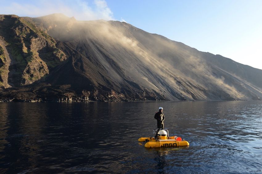
ALKOR-Berichte, AL 533, Catania – La Seyne-sur-mer, 5 Feb. – 18 Feb. 2020 5
2 Participants
2.1 Scientific Party
Name Discipline Institution
Hissmann, Karen Submersible JAGO / Chief Scientist GEOMAR
Schauer, Jürgen Pilot Submersible JAGO GEOMAR
Striewski, Peter Pilot Submersible JAGO GEOMAR
Weiß, Tim Software Engineer DSM GEOMAR
Wenzlaff, Emanuel AUV-Team GEOMAR
Leibold, Patrick AUV-Team GEOMAR
Diller, Nikolaj AUV-Team GEOMAR
Reißmann, Sylvia AUV-Team GEOMAR
Hampe, Hendrik Video-Technician GEOMAR
Klimmeck, Jens Cameraman 360° Imaging GEOMAR
Linke, Nikolas Photo- + Video-Documentation GEOMAR
Casalbore, Daniele Scientist volcanology USR
2.2 Participating Institutions
GEOMAR Helmholtz-Zentrum für Ozeanforschung Kiel
USR University Sapienza of Rome, Dept. Earth Science
3 Research Program
3.1 Aims and Agenda of the cruise
The aim of the AL533-cruise "JAGO-AUV-FieldTrials" was to perform mutual sea trials of two
untethered underwater research vehicles, the manned submersible JAGO and the Hover-AUVs
ANTON and LUISE (Type Girona500) in differently structured terrain at water depths of up to
500 meter. The tight program of science-focused research cruises usually does not leave enough
time for in-depth pilot and handling training and for testing of new technology. We therefore
applied ship time exclusively for those purposes. The sea trials should be performed under
conditions that are representative for typical research applications.
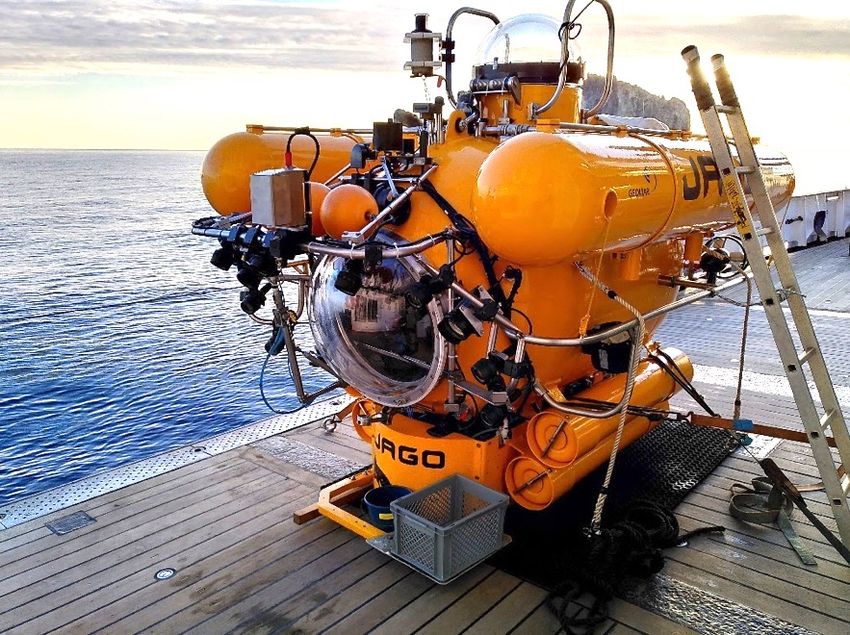
The GEOMAR-owned manned research submersible JAGO (see Figure 5.1.1.1), which
carries two people to maximum water depths of 400 m, is in operation since 30 years and has
performed more than 1400 dives. It is maintained and operated by a small team of three: two
technicians / pilots, and one scientific and operational coordinator (top-side dive supervisor). The
long-time chief pilot and technician, who joined all JAGO missions since the commissioning of
the submersible in 1989, is going to retire in the course of 2020. The pilot/technician who was
appointed to take over the chief pilot/technician position needed more sophisticated training
dives in complex and highly structured terrain, which cannot be found e.g. in the Baltic Sea close
to GEOMAR. Furthermore, the submersible recently underwent some technical changes.
Renewals comprised, among others, the integration of computer-controlled rim thrusters and
acoustic data transfer and communication via USBL. All renewals needed to be tested and – if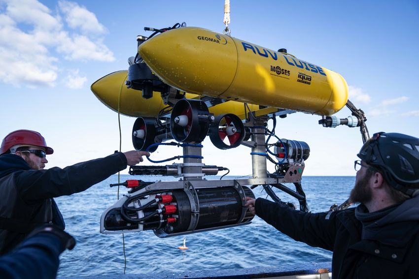
6               ALKOR-Berichte, AL 533, Catania – La Seyne-sur-mer, 5 Feb. – 18 Feb. 2020

necessary adjusted – under conditions that are typical for research cruises. They also needed to
be tested in larger water depths than those that can be reached in submarine habitats in the Baltic
Sea.
         The new hover capable Autonomous Underwater Vehicles (AUV) Type Girona500 –
named ANTON and LUISE – were bought by GEOMAR in 2018. They have a compact size of
1x1x1,5 m each (see Figure 5.2.1.1) and a total weight of up to 200 kg that includes all necessary
electronics and thrusters. The AUVs are capable of diving down to 500 m and have a battery
capacity for missions of up to 8 hours duration. The vehicles are equipped with various systems
that all together enable the precise calculation of their current position and allow real time
navigation (INS, DVL, GPS and USBL). The acoustic modems of the USBL system can also be
used to exchange basic information and simple commands between the surface control station
and the AUVs. The AUV-Team is presently developing a new navigation and communication
software network, named BELUGA, that enables (1) the monitoring of the movements of several
vehicles underwater and (2) the exchange of messages and commands between individual
vehicles and the ship, between several moving units themselves, and between vehicles and
acoustic transponders that are temporary moored on the seafloor. AL533 was used to test the
new BELUGA system in-depth at sea.
         Due to their modular design and a payload of 35 liters of volume, the AUVs can be
equipped with additional instruments for specialized tasks, e.g. a multibeam sonar for mapping
or cameras for photographic surveys. The AUV-Team recently developed a new camera system,
named CoraMo MK2 that needed to be tested for the first time under marine and deep-water
conditions.
         The AUV-team is still in the process of getting to know the vehicles, their possibilities
and their limits. All experiences especially gathered during sea trials and off-shore cruises are
therefore extremely helpful to improve this new technology for its future scientific use.
In summary, the major cruise objectives were:
    • Training of all aspects of operating and piloting the manned submersible JAGO from on
      board a research vessel under sea conditions similar to research cruises, including
      sampling with the manipulator arm and video mapping of heterogeneous terrain (low
      relief seafloor vs. high relief sites)
    • Testing of the submersible’s new side thrusters (computer-controlled rim thrusters)
    • Establishing acoustic data transfer and communication via USBL modem between the
      control station on board the vessel and the submersible, mainly for improving underwater
      navigation and orientation
    • Testing of the submersible’s emergency buoy release and rescue procedures
    • Establishing an USBL network with several modems in use
    • Testing and deployment training of novel shallow water Hover-AUVs as platforms for
      optical imaging (CoraMo MK2 camera system) and new underwater communication
      software (BELUGA software).
    • Testing next-generation marine research survey technology in the form of multiple
      communicating platforms (e.g. submersible, AUVs, moored transponders) to provide
      continuous and accurate underwater navigation as well as rapid feedback of sensor data
    • Collecting high-quality photo-, video- and 360°-images for various purposes of media
      and public outreach work at GEOMAR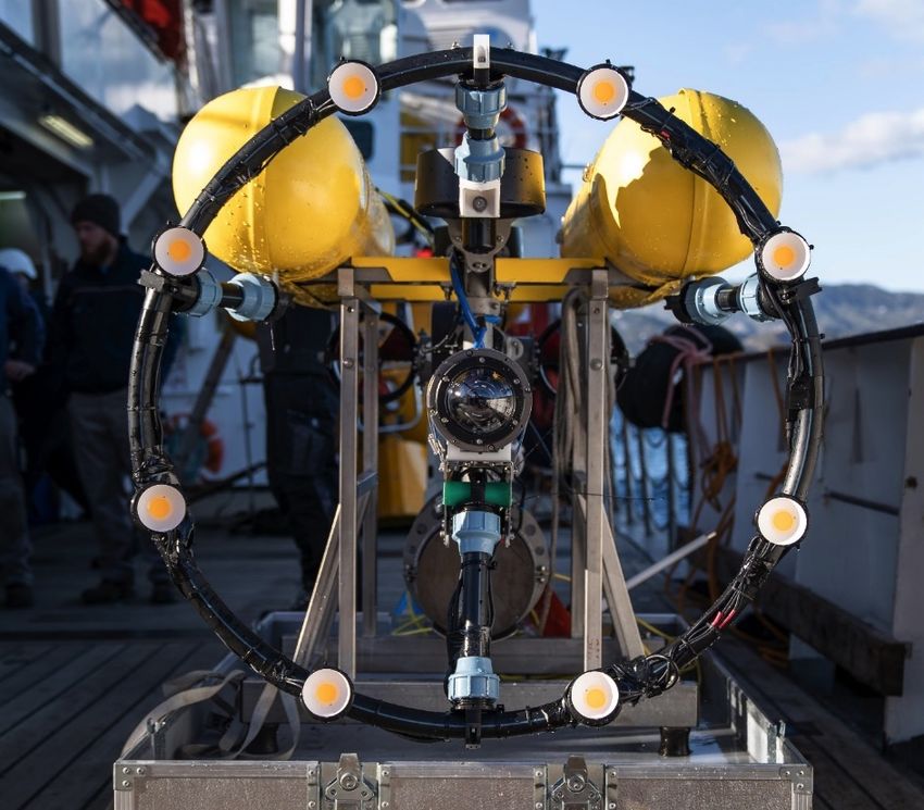
ALKOR-Berichte, AL 533, Catania – La Seyne-sur-mer, 5 Feb. – 18 Feb. 2020         7

3.2    Work area of the cruise
The selection of the region in which the cruise finally should take place was handled very
flexible in the proposal for ship time since the final route of the vessel was not defined at that
time. The main requirements for a suitable test area were: (1) structured submarine terrain at
water depths of up to 500 meters and (2) calm sea conditions that allow vehicle deployments
independently from weather conditions. Those conditions are for example usually found at the
lee side of high oceanic islands. The volcanic Aeolian Islands in the Tyrrhenian Sea north of
Sicily / Italy were finally selected as work area for AL533 (Figure 3.2.1) because they were close
to the work area of the previous ALKOR cruise (AL532). AL532 took place off the east coast of
Sicily and Catania was therefore the port of the cruise start of AL533. The Aeolian islands offer
sheltered sea conditions at their leeway, and bottom currents are usually weak or absent. Rocky
and steep slopes are located in short distances to areas with flat underwater topography, which
provided ideal test conditions.
        Suggestion for suitable dive sites around the Archipelago were provided by colleagues of
the University Sapienza in Rome who work since many years on the geology and volcanology of
the Aeolian islands (Romagnoli et al. 2013, Casalbore et al. 2010). The islands that were finally
selected for coastal dives were Vulcano, Lipari, Panarea and Stromboli. The sheltered bay
between Punta Roja and Punta Luccia in the Baia di Levante in the north-eastern sector of
Vulcano island was one dive site (38°24.70’N, 14°58.56’E). The Baia di Levante is a broken
caldera ring (La Fossa caldera rim) that is open to the east where it runs out into a deep gulf.
Gently sloping seafloor is found in close vicinity to steep slopes and almost vertical cliffs, the
remains of the caldera rim. The bay is well sheltered against the prevailing west wind by the
Fossa cone (391 m max. height) which is the dominant elevation on the volcanic island. A field
of well-distinguished pillow lava mounds of up to 70 m height each off the southeast coast of
Lipari Island (38°26.45’N, 14°58.12’E) provided a good test area for precise JAGO navigation
and maneuvering in rugged terrain. The east coast of Lipari island offers several other interesting
areas for test dives combined with some exploration options (e.g. 38°30.05’N, 14°58.10’E). The
submarine platform around Panarea island has a shallow topography and the seabed is mainly
covered with soft sediment. An area east of the island is called the “Panarea vent site”, a field of
volcanic gas seeps located between 10 and 80 m water depth (Schmidt et al. 2015). One of the
venting sites was chosen for testing a horizontal multibeam echo sounder attached to JAGO
(38°38.62’N, 15°05.18’E). The shallow topography was also ideal for AUV dives and a mutual
dive of both the submersible and AUV ANTON (38°37.43’N, 15°04.61’E). The Sciara del
Fuoco, the northwest slope of the active Stromboli volcano (38°48.19’N, 15°12.15’E) was of
special interest of the Italian colleague. Here, a long video and sampling transect with the
submersible was performed along the 100 m contour line.
8 ALKOR-Berichte, AL 533, Catania – La Seyne-sur-mer, 5 Feb. – 18 Feb. 2020
Fig. 3.2.1 Track chart of R/V ALKOR Cruise AL533.
4 Narrative of the Cruise
The submersible container and the Hover-AUVs, which were transported to Catania by truck,
were delivered to the berth of FS ALKOR in Catania port on 03 February. A port crane
transferred the submersible, its transport container, and the AUVs on board of ALKOR in the
afternoon. The submersible container was lashed down on the aft deck, the submersible on the
starboard deck next to the opening of the ship’s side, and the AUVs in the hangar. The dry lab
was chosen as control lab for both the submersible and the AUV operation. The cruise
participants started with installing the support equipment immediately after the equipment was
loaded on board the vessel.
04–05 February. All participants of AL533 including the Italian guest scientist officially
embarked the vessel in the morning of February 04. In a meeting between the Captain and the
Cruise leader it was decided to postpone the departure of the vessel by two days to avoid the
forecasted strong wind and high swell in the Strait of Messina and the Tyrrhenian Sea north of
Sicily. The forecasted sea conditions would have made it difficult to pass the Strait and the area
north of it during transit to the Aeolian Islands. The additional two days in port were used for
further preparations of the submersible and the AUVs and the installation of their support
equipment (USBL in the moon pool etc). The multibeam maps of the work areas, which were
provided by the Italian colleague, were calibrated for their integration into the navigation
software. In a meeting, all participants of the cruise including the Captain and the crew were
informed in detail about the aim to capture comprehensive material for public outreach purposesALKOR-Berichte, AL 533, Catania – La Seyne-sur-mer, 5 Feb. – 18 Feb. 2020 9
(photographs, videos, aerial shots by drone and 360°-video). Afterwards all participants signed a
declaration of consent for the use of personal images and personal data.
06 February. FS ALKOR left the port of Catania early in the morning at 06:18. The
transit towards the Tyrrhenian Sea was performed in slow speed due to the still unfavorable
conditions north of the Strait of Messina. They improved only slowly during the day. The chief
mate provided comprehensive safety instructions to all cruise participants, and afterwards the
teams continued with their technical preparations.
07 February. The Strait of Messina was passed at 05:00. During the morning, the crew
was introduced to the steps of the launch and recovery procedure the submersible. The deck crew
prepared the work boat and the necessary lines for the first deployment. The vessel arrived at the
first work area, the Baia de Levante off Vulcano, at 10:40. At first, the Captain and the Cruise
leader watched the fast ferries passing by to get a general idea of the local traffic. The highly
frequented ferry route runs close to the selected dive sites. After lunch, the handling trials with
JAGO took place (deployment and recovery of the submersible with the modified / shortened
main deck crane). In the afternoon, AUV LUISE was deployed for a trim test and a first acoustic
communication test with the EvoLogics transponder. The transponder was lowered only few
meters into the water and stayed attached to the telescopic crane on the starboard aft.
Communication tests were also performed with the USBL modem that was going to be attached
to JAGO for tracking the submersible under water. The USBL data were implemented into the
navigation software OFOP and the BELUGA system.
08 February. After breakfast, the first JAGO dive (#1426-1) with Peter Striewski as pilot
and Nikolaj Diller as observer was performed in the bay between Punta Roja and Punta Luccia
off Vulcano. Sampling of volcanic rock was not possible due to a technical problem with
JAGO’s manipulatior arm. The lunch break was used for the transit to Panarea Island where the
first AUV dive should take place. The AUV team selected a dive site with a shallow bottom
depth to ensure that the DVL sensor on AUV ANTON would have a bottom log before the AUV
submerges. Meanwhile the cruise leader and Daniele Casalbore applied for a permit to enter and
dive within the restricted zone off the Sciara del Fuoco, the northwest slope of the Stromboli
volcano, at the coast guard office of Milazzo / Sicily. During the late evening hours, the entire
team and crew on board observed the impressive lava throw-offs of the Stromboli volcano.
09 February. JAGO dive 1427-2 with Peter Striewski (pilot) and Tim Weiß (observer)
took place at the Panarea vent site to test the mini multibeam sensor, attached to JAGO’s front,
for gas bubble detection and as forward-looking scanning sonar. Afterwards, a short test dive of
AUV LUISE was performed. During lunch break the work permit for the restricted zone off
Stromboli arrived. After a short transit from Panarea to Stromboli, JAGO dive 1428-3 with
Jürgen Schauer as pilot and Daniele Casalbore as observer took place in the afternoon. It was a
long video and rock sampling transect along the 100-m contour line of the northwestern slope of
the volcano. Everybody else on board enjoyed the spectacular view onto the active Stomboli
volcano and its periodical and very predictable mini-explosions with small lava fountains and
glowing material that rolls down the northwestern slope and often reaches the sea. The first
comment of Daniele Casalbore about the dive after disembarking JAGO was that a lifetime
dream has become true for him who works since his PhD thesis on the volcanism of Stromboli.
10 February. The early morning hours were used for the transit from Stromboli back to
the Baia de Levante of Vulcano. After breakfast, JAGO dive 1429-4 with Peter Striewski (pilot)10 ALKOR-Berichte, AL 533, Catania – La Seyne-sur-mer, 5 Feb. – 18 Feb. 2020
and Nikolas Linke (photographer) as used to explore the submarine parts of the Punta Roja lava
flows and produce still photo and video clips from inside the submersible. Although the wind
increased in the afternoon, the AUV could be deployed for further test missions in the sheltered
bay between Punta Roja and Punta Luccia. After 16:00 the wind bursts became too strong for
safe deployments and recoveries. A shift to the southern coast of Vulcano did not provide more
wind shelter. The vessel moved to the east coast of Lipari into the Baia di Lipari to weather the
partly very strong gusts of wind (Maestrale - katabatic wind from northwest).
11 February. The Maestrale wind did not die through the night and prevented all
deployments that were planned for that day at a location off the Capo Rossa, Lipari Island. The
vessel returned into the Baia di Lipari to weather the gusts of wind (Bft 8-9). The team on board
spent the time with working on system and software improvements.
12 February. On the next day, the weather allowed two test dives of the AUV in the Baia
de Levante off Vulcano. In the afternoon, JAGO dive 1430-5 with Peter Striewski (pilot) and
Emanuel Wenzlaff (observer) were performed along the submarine Punte Nere lava flows below
the La Fossa Cone. The dive was primarily used to measure the performance of the new side rim
thrusters on the submersible with an oscilloscope, but also two rock samples were collected.
13 February. The stunning calm and sunny morning was used for a photo, video and
drone imaging session of the submersible and the AUVs – both floating at the water surface – in
front of FS ALKOR and the La Fossa Cone in the background. It was followed by a dive of
AUV ANTON. The lunch break was used for the short transit from the Baia de Levante to the
pillow lava field off the southeast cape of Lipari. JAGO dive 1431-6 with Jürgen Schauer (pilot)
and Karen Hissmann (observer) was dedicated to video document and sample the pillow lava
mounds at this site and to test the navigation performance based on USBL data provided on a
tablet PC inside the submersible for maneuvering in rugged terrain. The dive among the pillow
lava mounds was very impressive. After returning to the Baia de Levante, the EvoLogics seabed
transponder EMIL, which also has an integrated acoustic releaser mechanism, was deployed and
moored at the seafloor for the first time.
14 February. AUV ANTON was deployed early in the morning for a long test dive. A
photograph of the entire scientific team was made in front of JAGO and LUISE before the Italian
guest scientist, Daniele Casalbore, was disembarked and transferred by the ALKOR work boat to
the port of Vulcano. The seabed transponder EMIL, that had been stationed on the sea floor the
day before, was acoustic released and recovered before the lunch break. After this, AUV
ANTON surfaced after a successful long dive and was brought back on board before the wind
picked up distinctively. In the afternoon no further deployments were possible due to the strong
wind gusts (Bft 6-7). The vessel sheltered in the Baia di Lipari for the rest of the day.
15 February. After sunrise, the vessel moved to the Capo Rosso off the westcoast of
Lipari Island. AUV ANTON was deployed in the water for a dive from shallow into deep water
depth. The mission had to be aborted due to DVL failure. It was therefore decided to move
earlier to Panarea for the last stations. After lunch, JAGO and AUV ANTON were deployed off
the south coast of Panarea for a rendezvous dive in shallow water depth. JAGO took video
images of the cruising and hovering AUV and the camera system on the AUV captured still
images of the submersible. The submersible crew used the dive to test the performance of two
different HD survey cameras. At the end of the dive, JAGO’s emergency buoy was released to
test the rescue procedure. The release was documented with a GoPro camera attached to theALKOR-Berichte, AL 533, Catania – La Seyne-sur-mer, 5 Feb. – 18 Feb. 2020 11
submersible. When the rescue buoy had reached the water surface it was recovered by the team
on the accompanying work boat. AUV ANTON performed a second final dive at the same
location. After recovery and securing all equipment on deck, the official work program of
AL533 was finished. ALKOR left Panarea at 15:30 and started the 500 nm transect to La Seyne-
sur-mer.
16 February. During the first day of a calm transit, all teams were busy storing data and
started packing, and the media team made video- and 360°-camera interviews with some of the
cruise participants for a planned documentary. After dinner, they presented some of their
plentyful images, for example the spectacular drone flights over the La Fossa Cone on Vulcano
and along the Sciara del Fuoco on Stromboli. The vessel reached the Strait of Bonifazius
between Sardinia and Corsika at 20:00.
17 February. The rest of the transit remained calm and, just in time before the forecasted
strong winds set in, the vessel entered the port of La Seyne-sur-mer / France. It docked at
14:36 opposite to the Mediterranean base of the French Marine Research Institution IFREMER.
The JAGO-team got in touch with the Head of the Technology System Unit and was lucky to get
an appointment for all cruise participants for a visit of the IFREMER Technology Centre the
next day. The Captain and the Cruise Leader exchanged and finallized together the cruise
summary reports and the teams continued packing and cleaning cabins and labs.
18 February. During the morning, the teams finallized packing the transport boxes and
stored them either on palettes or inside the submersible container. At 15:00, the entire team got a
very impressive tour on IFREMER’s deep-diving manned submersible NAUTILE and the ROV
VICTOR, led by Jan Opderbecke. Jan answered very openly and patiently the many technical
and organisational questions of the GEOMAR team. It was a great visit. The cruise participants
were disembarked from ALKOR at 18:00 and transferred to the Hotel located at the marina of La
Seyne sur-mer.
19 February. In the morning, the cruise participants walked back to the vessel. The
ordered mobile crane and the transport trucks arrived at 08:30. The submersible container was
transferred onto the pier where the submersible was then placed onto the extended rails in front
of the container and then pulled into it by winch. The AUVs and the other boxes were loaded on
a separate truck. The team members then said goodbye to the ALKOR crew, walked back to the
hotel from where all of them were transferred to the airport of Marseille for their return flights to
Germany.
5 Preliminary Results
The cruise lasted in total 11 and ½ days and the total distance travelled was 795 nm. Due to
unfavorable wind and sea conditions, the vessel departed two days later from Catania and left the
working area one day earlier because of the forecasted strong wind in southern France. A total
number of 18 stations were executed. No station work was performed on the transit from the
Aeolian Islands to southern France, where the cruise ended in the port of La Seyne-sur-mer
(Provence). Vehicle deployments were possible on 7 ½ days out of 9 days in the work area; thus
only 1 ½ day was lost for work on deck due to weather. This is a good ratio for a research cruise
with a medium sized vessel at this time of the year in the Mediterranean Sea. The Aeolian
Islands provide sufficient dive sites close to the coast that are suitable for this kind of equipment
tests.12 ALKOR-Berichte, AL 533, Catania – La Seyne-sur-mer, 5 Feb. – 18 Feb. 2020
The teamwork and spirit between the science party and the ALKOR crew was excellent
and enabled productive as well as enjoyable work on board the vessel. Smaller teams – in this
case consisting of in total 23 persons on board – enable close communication and hand-in-hand
work between the science party and the crew. The ALKOR crew was also very cooperative and
patient in supporting the extensive photo and video shooting on board. Their consent to be
photographed and filmed in all kinds of work situations, however, should not be taken as a
matter of course during research cruises. Their willingness to cooperate is therefore highly
appreciated.
FS ALKOR is a medium-sized research vessel that – at least according to the experiences
gained during this cruise – is suitable to serve research projects also outside of its usual operation
area in the North and Baltic Sea, even more after some modifications. The vessel proved to be a
suitable platform for the deployment of larger scale research equipment like the submersible
(weight in air 3 tons) and the Hover-AUVs (ca. 200 kg) in calm seas. The handling of the
submersible from on board the ALKOR is, however, at the moment restricted to relatively calm
conditions because of the main deck crane. The crane has not sufficient lifting capacity at its
outer knuckle boom lifting point. The crane-cable and thus the lifting point had to be relocated to
the end of the main / inner arm which shortens the maximum out reach of the crane by at least 3–
4 m and reduces its speed. Thus, JAGO had to be picked up and lifted out of the water in a
narrow distance of less than 2 m to the ship’s side which enlarges the risk of bouncing against
the ship’s hull and bulwark if the ship roles and pitches. A replacement of the present crane
would improve the vessel’s lifting capability not only in respect to the JAGO handling with
larger safety but also to its general capability to lift heavier gear at sea. It also would enable
loading and offloading of equiment heavier than 5 tons on and off deck independently of being
assisted by land cranes.
5.1 Dives with the manned submersible JAGO
(K. Hissmann, J. Schauer and P. Striewski)
5.1.1 Short System Description
The GEOMAR-owned manned submersible JAGO can take two persons – a pilot and a scientific
observer – to water depths of maximum 400 m (Figure 5.1.1.1) (GEOMAR, Hissmann, Schauer,
2017). The submersible has a compact size of 3x2x2.5m LWH and a low weight of 3 tons that
enables shipment in a single 20’ ISO container and deployment from a wide variety of support
vessels with sufficient crane capacity. The submersible operates worldwide since 1989 and is
regularly used from on board the German research vessels including FS ALKOR.
The power for all electrical systems of the submersible is provided by lead-acid batteries.
The propulsion system comprises seven electrically powered thrusters that enable precise
manoeuvring of the submersible in all directions. Vertical movements are performed by
controlled changes of buoyancy, initialized by streaming or releasing a defined amount of water
or air into or out of a variable ballast tank. Two large 360-litre diving tanks provide buoyancy
and stability when the submersible is floating at the water surface. They are flooded for
submerging and filled with air for surfacing.
JAGO is equipped with fluxgate compass, vertical and horizontal sonar, underwater
telephone for voice communication (UT), LED lamps, digital video (HD) and still cameras, CTDALKOR-Berichte, AL 533, Catania – La Seyne-sur-mer, 5 Feb. – 18 Feb. 2020 13
sensors and a manipulator arm for collecting and handling various sampling devices and
instruments. For calculating the submersible’s position under water and tracking its movements,
different USBL navigation and positioning systems have been used on JAGO in the past. During
AL533, devices of the EvoLogics S2C R USBL positioning and communication series were
used. One goal of the cruise was further testing of their functionality for exchanging data and
messages between the control station on board the vessel and the submersible.
During the dive, the pilot is solely in charge for the safe navigation and maneuvering of
the submersible and for the communication with the support vessel. He is also operating the
submersible’s manipulator arm to handle sampling tools and deploying / recovering instruments,
and he is controlling sensors and the video and still cameras for documentation of the
environment. This multitasking and – at the same time – responding to the scientific and
personal needs of the accompanying scientist, requires a lot of training and experience but also
intuition and fine motor skills. Taking a passenger (scientist) to a water depth of up to 400 m and
being solely responsible for the safety of both the inhabitants, requires from the pilot full
concentration and confidence. The submersible team is presently going through a personal
exchange period, since Jürgen Schauer, the long-time chief pilot, is going to retire in the course
of this year. His successor and a new second pilot have to be well trained and prepared for their
responsible jobs. Pilot training and gaining more steering experience in complex terrain were
therefore main aims of this cruise.
Fig. 5.1.1.1 Submersible JAGO during recovery from a dive in the Baia de Levante between Punta
Luccia and Punte Nere off the Aeolian island Vulcano. In the background the La Fossa Cone, the
dominant feature on the island (Photo: Karen Hissmann)14 ALKOR-Berichte, AL 533, Catania – La Seyne-sur-mer, 5 Feb. – 18 Feb. 2020
JAGO Specifications
• Owner and Operator: GEOMAR Helmholtz Centre for Ocean Research Kiel
• Crew: 1 pilot, 1 observer
• Maximum operating depth: 400 m
• Dimensions: Length 3.0 m, Width 2.0 m, Height 2.5 m
• Personnel cabin dimensions: Length 2.13 m, diameter 1.29 m
• Personnel cabin volume: 2.5 cubic meters
• Weight in air: 3,000 kg
• Maximum payload: 250 kg
• Pressure hull material: Steel
• Viewports: acrylic, 1 bow-window (ø 700 mm), 1 top dome / hatch (ø 450 mm)
• Power supply: lead-acid batteries, total capacity 13 KWh – 24 VDC
• Propulsion: electrically powered thrusters – 3 reversable thrusters at stern, 2 rotational
thrusters on starboard and port side, 1 front and 1 aft thruster
• Cruising speed: 1 knot
• Emergency Life Support: 96 man hours
• Safety and Rescue Systems: Emergency drop weight, dead-man’s switch, releasable
emergency buoy, generation of >500 kg positive buoyancy
• Lighting: 9 multiple positional LED lamps, laser scaling
• Standard equipment: Underwater navigation and positioning system (USBL), voice
communication through acoustic underwater telephone (UT), electronic compass,
redundant depth sensors, vertical and horizontal sonar, hydraulic manipulator arm,
GPS sensor for surface navigation, marine band (VHF) radio for surface
communication
• Imaging: Full-HD video cameras for through viewport documentation, hand-held
digital still camera, flashes, in-hull hard drive video recorders and monitors
• Scientific sampling equipment: CTD, temperature probes, sample boxes for biological
samples or rock collection, water sampler (NISKIN), push corers for sediment
samples, fluid and gas samplers, scoop nets and cups, acoustic marker beacons
• Launch & Recovery: man-rated single lifting point
• Transport: 1 x 20’ ISO Container or on custom road trailer
• Classification: DNV-GL Hamburg
5.1.2 Overview of the submersible dives and first results
Between February 08–15, 2020, a total of seven dives were performed with the manned
submersible JAGO. Dives took place at maximum bottom depths between 50 and 310 meters at
4 different islands. The total dive time was 16 hr during which 12.5 hours of HD-video film was
captured. A total of 21 volcanic rock samples were collected at different sites of interest for
analyses by the Italian colleagues. Dives were mainly dedicated to train piloting, sampling and
video-recording in rugged and steep terrain, and to establish the routine transfer of USBL
positioning data from the control station / base on the vessel to the submersible via modem.
During one of the dives the performance of the two side rim thrusters was measured in detail
with an oscilloscope that was taken on board for the dive. Another dive was dedicated to
rendezvous under water with one of the AUVs and to shoot video footages of the AUV (see
Figure 10.1.3). During the last dive the release of the rescue buoy was tested.ALKOR-Berichte, AL 533, Catania – La Seyne-sur-mer, 5 Feb. – 18 Feb. 2020 15
The advantage of dives without a strong focus on a scientific goal or outcome is that all
aspects of science dives can be trained without the expectations of typical research missions.
During science dives, the JAGO pilot is usually accompanied by a scientist who often has not
been in a manned submersible before and thus cannot assist in any of the required actions. In a
two-persons submersible like JAGO, a trainee pilot will be, at some point, on its own, together
with a passenger. If needed, he can get verbal support by a senior pilot via the underwater
communication system (UT) on board the support vessel. But most of the piloting skills a trainee
will gain through learning-by-doing, meaning diving. Peter Striewski is successfully piloting
JAGO for a few years now and AL533 gave him another opportunity to navigate JAGO in
different and quite challenging terrain. He steered JAGO on five out of the seven dives that were
conducted off the Aeolian Islands.
A large improvement for the pilot and the accompanying observer is the availability of
the USBL positioning data inside the submersible (see chapter 5.4), which became a routine
during AL533 by using the mobile EvoLogics USBL system. During the course of the dive, the
submersible crew can see JAGO’s current position now on a tablet PC. The therefore used
software SiNAPS (also chapter 5.4) also allows the integration of geo-referenced seafloor maps,
e.g. bathymetry maps or multibeam images. The continuously updated USBL positions are
projected onto these maps. The pilot can navigate the submersible towards interesting features or
around obstacles according to the map. This setup worked extremely well and reliable during
AL533. The USBL system and the way it was set up (see chapter 5.4) provided quite good
absolute positioning accuracy and thus a smooth track with only few position jumps. In former
times, the submersible crew had to be guided towards points of interest by the dive supervisor on
board the vessel via underwater telephone communication (UT). The dive supervisor monitors
the underwater movements of the submersible on a PC with the same USBL tracking and
navigation software. He tells the pilot via UT in which direction he has to navigate and for how
far. Sending USBL data from the surface unit of the USBL system to the submersible, however,
is only possible with USBL systems that offer a communication link via modem. USBL systems
like the ones installed e.g. on RV SONNE or on RV METEOR (both IXblue Posidonia) do not
offer this option. At the moment this is only possible with the EvoLogics system and with the
Ranger II system of Sonardyne Ltd UK (permanently installed e.g. on RV M.S.MERIAN).
Dive highlights were a geological survey along the ca. 45°-slope at the northwest side of
the active Stromboli volcano, the “Sciara del Fuoco” or “fire slide” (see Figure 10.1.2). The
survey was in particular for Daniele Casalbore, who joined the dive and investigates the
submarine landslides and volcanic eruptions at Stromboli for many years, a unique personal
experience. Another dive with impressive geological features was JAGO dive 1431(06) / station
15-2 performed off the southeast coast of Lipari island. Main target of the dive was a field of
large and very distinct pillow lava mounds that were up to 30 m high each. Their flanks were
covered with long tubular or rounded lava lobes with wrinkled surfaces (pillow lava) (Figure
5.1.2.1). The volcanic rocks were only sparsely colonized by benthic organisms. An impressive
encounter was a large bluntnose sixgill shark (Hexanchus griseus) at 300 m water depth at the
base of one of the mounds. The pillow lava field was a perfect test site for the usefulness and
benefits of receiving the USBL positioning data inside the submersible, projected on a
multibeam map of the area. It enabled the JAGO crew to navigate the submersible through the16 ALKOR-Berichte, AL 533, Catania – La Seyne-sur-mer, 5 Feb. – 18 Feb. 2020
cluster of steep mounds towards the shallower saddle between Lipari and Vulcanello islands
without verbal support by the dive supervisor on board the vessel.
Fig. 5.1.2.1 Field of pillow lava mounds east of the channel between Lipari and Vulcanello island.
Left: Multibeam image provided by Daniele Casalbore. Right: Features of pillow lava documented by
submersible JAGO at 280 m water depth (Photo: Karen Hissmann / Jürgen Schauer).
5.2 Dives with the AUVs ANTON and LUISE
(M. Rothenbeck, E. Wenzlaff, N. Diller, S. Reißmann, P. Leibold)
5.2.1 Short System Description
AUV ANTON and LUISE
The devices ANTON and LUISE are both so called AUVs – Autonomous Underwater Vehicles.
The vehicles of the type GIRONA 500 were developed originally by the GIRONA Underwater
Vision and Robotics Lab of the University Girona (Spain) in the early 2010 (Ribas et al. 2012).
The AUVs ANTON and LUISE themselves were built by IQUA Robotics, a spin-off company
of the Lab. Both vehicles joined the GEOMAR AUV group in 2018/19 as part of the HGF
infrastructure project MOSES. The GEOMAR AUV group is operating since 2008 a fast
torpedo-shaped AUV for mapping of large seafloor areas during long missions (ABYSS,
REMUS 6000 type). In contrast, the GIRONA type AUVs are so called hover capable AUVs,
small and lightweight AUVs that are designed for slow speed manoeuvring to gather high-
resolution data in small areas or in specific locations (Figure 5.2.1.1).
ANTON and LUISE have a maximum operating depth of 500 m and they are
reconfigurable. Each vehicle is composed of an aluminium frame, which supports three torpedo-
shaped hulls of 0.3 m in diameter and 1.5 m in length as well as other elements like the
5 thrusters. The two upper hulls contain the main electronics housing, the Inertial Navigation
System (INS), the acoustic modem, the pressure sensor, the antenna, several connectors and
flotation foam. The lower compartment contains the heavier parts like the battery, the Doppler
Velocity Log (DVL) and the payload section. The overall dimensions of the vehicle are 1 m in
height, 1 m in width, 1.5 m in length and the total weight is less than 200 kg. The particular
arrangement of the components clearly separates the vehicle’s centre of gravity from the centre
of buoyancy, which is not the case in a typical torpedo shaped design. The vehicle gains passive
stability in pitch and roll by this separation, making it e.g. suitable for slow imaging surveys.1
1
http://iquarobotics.com/girona-500-auv, 2020ALKOR-Berichte, AL 533, Catania – La Seyne-sur-mer, 5 Feb. – 18 Feb. 2020 17
One of the main reasons for GEOMAR to choose this AUV type was the AUV software
architecture COLA2. Cola2 is an open source software package. It enables the GEOMAR AUV
group to integrate different sensors or adapt the vehicle according to the diverse needs in marine
science. One of the goals is that the vehicle interacts with its environment or with other vehicles
and devices. For this kind of interactions while submerged, the GEOMAR AUV group is
presently developing the command and control software BELUGA (see below), which was
extensively tested during AL533.
Fig. 5.2.1.1 Hover capable AUVs ANTON (top) and LUISE (below) on board the RV ALKOR
during AL533, both with CoraMo camera system attached to the front (Photos: top Nikolas Linke / below
AUV Team).18 ALKOR-Berichte, AL 533, Catania – La Seyne-sur-mer, 5 Feb. – 18 Feb. 2020 The standard sensors of AUV ANTON and LUISE, which are installed on each mission, are: INS - iXblue Phins Compact C3 The internal navigation unit that processes sensor data and provides position information. The error of this INS is in range of 0,15° for heading and 0,05° for roll and pitch. This leads to a 0,3% DT position accuracy (if aided by DVL). DVL - Teledyne RDI Explorer 600kHz This device measures the vehicles’ velocity relative to the sea floor and its altitude. CTD - Sea-Bird SBE 49 FastCAT This measurement device acquires the conductivity, the temperature and the pressure of the water and calculates the sound velocity. Pressure sensor - Valeport ultraP This sensor measures the pressure and converts it to water depth. USBL2 - Evologics S2CR 18/34 The Evologics S2CR 18/34 modem combines underwater acoustics and positioning. GPS - Quectel l86 GNSS module The GPS is used to determine the vehicle’s absolute position at the surface. Optional payload sensors are for example: MBES3 - Imagenex 837B DeltaT 4000 The optionally mounted multibeam sonar is used for seafloor mapping. During AL533 the MBES was only used on the submersible JAGO (See chapter 5.6). Camera - CoraMo Mk II Down or forward-looking camera system for photographic surveys with an image rate of up to 2 images per second with a resolution of 12.34 MP. For illumination, CoraMo is connected with 8 high power LEDs. The CoraMo Camera was the standard payload on each AUV dive during AL533. IQUAview IQUAview is a graphical user interface (GUI, Figure 5.2.1.2) developed by IQUA Robotics that allows operating the GIRONA500 type vehicles. IQUAview provides a front-end to the COLA2 software architecture. It enables the operators to communicate with the robot, to configure a basic set of parameters, and to plan and monitor missions by using an intuitive graphical interface4. IQUAview is based on QGIS, an open source Geographic Information System (GIS). This GUI was delivery with each of the GIRONA500 vehicles. Unfortunately, it allows to communicate with only one vehicle at a time. This was one of the reasons why BELUGA was developed. IQUAview, however, still has to run in parallel to BELUGA since some features like mission planning or setting parameter has not been implemented in BELUGA yet. 2 USBL – Ultrashort Baseline (See chapter 5.4) 3 MBES – Multibeam Echosounder 4 https://bitbucket.org/iquarobotics/iquaview/src/master/, 2020
ALKOR-Berichte, AL 533, Catania – La Seyne-sur-mer, 5 Feb. – 18 Feb. 2020   19

Fig. 5.2.1.2     Graphical User Interface IQUAview

BELUGA – Marine C&C System
BELUGA is a project of the GEOMAR AUV group, which encompasses not only the
development of a software tool to operate the AUVs in parallel, but is supposed to create also an
infrastructure for future positioning and communication features for different types of
underwater vehicles and equipment. The BELUGA project is part of the project « Robotische
Exploration im Netzwerk » funded by the Werner Petersen Stiftung Kiel.
         Like IQUAview, also BELUGA consists of a GUI, however, it is not just the graphical
interface of COLA2. BELUGA, instead, has a complex backend that is able to communicate
with COLA2 on the vehicles via the communication language protocol DCCL5 (Schneider et al.
2010). In this way BELUGA is able to communicate not only with one but with several
platforms that understand this language protocol. Originally BELUGA was supposed to
implement the language protocol CCL (Stokey et al. 2005), which is part of the software VIP
(Freitag et al. 2005), the GUI of the GEOMAR REMUS6000 AUV. But DCCL is more flexible
in terms of message size. Since QGIS is a very common GIS tool and since IQUAview also uses
it, the navigation map of the BELUGA frontend is based on this open source tool.
    In summary, BELUGA consists of a base (control station) and several platforms, as on AL533
two GIRONA500 AUVs and two EvoLogics transponders. The base encompasses the backend,
the frontend, the acoustical USBL modem and the operator. The frontend was not ready during
AL533, so only a rudimentary first version was used to visualize the data of the backend. Each
platform (AUV, transponder, JAGO) is equipped with an EvoLogics S2CR 18/34 Modem. The
modem enables acoustic communication with the base and with the other platforms. Aside from
that, the modem is also a USBL beacon, its relative position under water is detected by the
USBL modem of the base on the ship (see section 5.4). The positions of the submerged
platforms are calculated and provided by SiNAPS, a software tool of EvoLogics (section 5.4).
SiNAPS runs parallel to BELUGA and is used by the BELUGA backend. The network layer
EvINS – a polling protocol – was also implemented. EvoLogics developed this network protocol

5
    DCCL – Dynamic Compact Communication Language
20 ALKOR-Berichte, AL 533, Catania – La Seyne-sur-mer, 5 Feb. – 18 Feb. 2020
package in an externally funded project. It was initially integrated into the EvoLogics software
by another party and their approach was rather experimental. During AL533, EvINS was
implemented properly. Now, the base on board the vessel is all the time the requesting part and
the submerged platforms answer.
Fig. 5.2.1.3 BELUGA structure during AL533
5.2.2 Overview of the AUV missions performed during AL533
Trim Test – 07.02.2020 - Station 3-1
The first AUV deployment was a trim test for the AUV LUISE on February 07. The goal of that
test was to gain a good balance of the vehicle in Mediterranean water. The deployment was
performed with the starboard aft crane and it was also a handling test for the setup of the
launching and recovery gear.
Tripple Camera mission – 08.02.2020 – Station 5-1
At Panarea, AUV ANTON did several missions in a row to determine the best setting parameters
for the attached camera system. In addition, the first acoustic messages were exchanged through
the BELUGA system. The messages sent from the AUV to the base showed the status of the
vehicle like its internal INS position and immersion depth. The actual position of the vehicle was
measured via the USBL modem attached to the ships’ moon pool.
Stat. AUV Start End Duration Data Max Remarks
# Mission # Pics Size Depth
5_1 Anton 85 12:20 13:15 55 min 3220 7.2 GB 40m Different altitudes 10m-40m
Fixed camera settings
5_1 Anton 86 14:30 15:00 30 min 182 493 MB 40m Different altitudes 10m-40m
Automatic settings, only 1
Pic/10s
5_1 Anton 87 15:21 15:54 33 min 187 219 MB 40m Different altitudes 10m-40m
Fixed settings
1 Pic/10sSie können auch lesen