Wanderparadies - Kronplatz
←
→
Transkription von Seiteninhalten
Wenn Ihr Browser die Seite nicht korrekt rendert, bitte, lesen Sie den Inhalt der Seite unten
P U S T E RTA L | VA L P U S T E R I A

                                         Wanderparadies
                                            PARAD ISO D I   ESCURSI ON I | H I KI NG PARAD ISE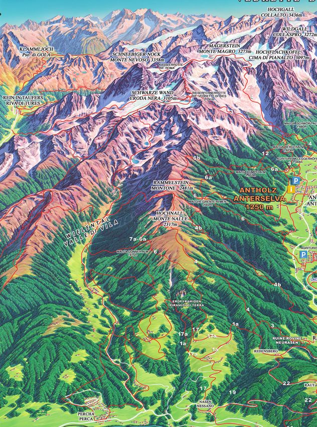
INHALTSVERZEICHNIS | INDICE | INDEX

                                      Inhaltsverzeichnis
                                      Indice | Index

                                                                                                                                Seite | pagina | page
                                           Almen | malghe | Alpine Huts                                                                  4

                                           Berggasthäuser – Hofschenken | Alberghi alpini – Agriturismi
                                                                                                                                         11
                                           alpine inns

                                           Einkehrmöglichkeiten am Talschluss | Possibilità di ristoro a
                                                                                                                                         12
                                           fine valle | rest and snack stations in the head of the valley

                                           Unsere Wandertipps | nostri consigli per escursioni | Hiking Tipps                            13

                                           Almen in der Umgebung | Malghe nei dintorni
                                                                                                                                        36
                                           Alpine cottages in the neighbourhood

                                           Schutzhütten | Rifugi alpini | Alpine Huts                                                   37

                                           Tourenvorschläge MTB | Proposte per gite in mountainbike
                                                                                                                                        39
                                           Mountain bike tours

                                           Infos für den Biker | Informazioni per i ciclisti
                                                                                                                                        44
                                           Information for cyclists

                                           Nützliche Telefonnummern | Numeri utili | Useful numbers                                     45

                                           Zeichenerklärung | Legenda | Legend                                                          45

                                            Tourismusverein Antholzertal | Ass. Turistica Valle Anterselva
                                            Tourist Info Antholzertal
                                            39030 Rasen/Antholz - Rasun/Anterselva
                                            Südtirol - Alto Adige - Italy
                                            T +39 0474 496 269 | Fax +39 0474 498 099
                                            www.antholzertal.com | info@antholzertal.com
                                            Impressum:
                                            Herausgeber: Tourismusverein Antholzertal
                                            Fotos: Tourismusverein Antholzertal, Renzler Caroline, Wisthaler Harald, Schuster Barbara
                                            Grafische Gestaltung: Rotwild GmbH | Druck: Esperia

                     2 | Antholzertal | Valle Anterselva
Ein großer Dank gilt den
Grundbesitzern für die Bereitstellung
der Wege und Wälder. Wir bitten die
Besucher um einen respektvollen Umgang .
Ringraziamo i propietari per la disposizione dei sentieri
e delle foreste. Chiediamo i visitatori di rispettare la natura.
Thanks to the landowners for the supply of paths and forests.
We ask the visitors to a respectful handling.
Almen
ALMEN | MALGHE | ALPINE HUTS
Malghe | Alpine Huts
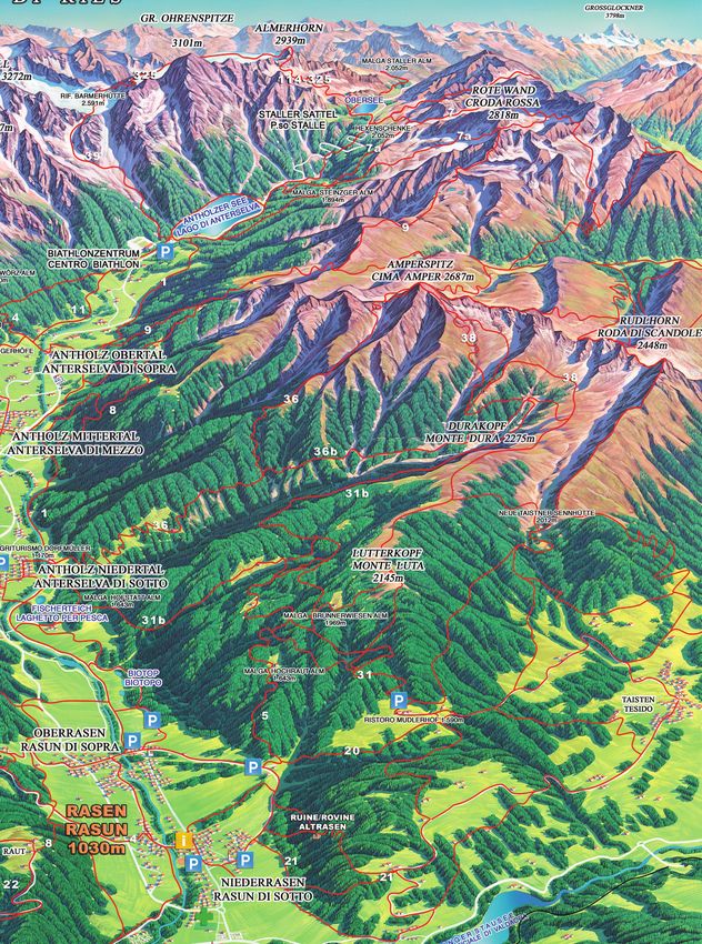
HOCHRAUTALM | MALGA HOCHRAUT (1.643 m)
D I E
Geöffnet von Mitte Aperta da metá Open from the
Juni bis Ende Okto- giugno a fine otto- middle of June until
ber. Dienstag Ruhe- bre. Giorno di ripo- the end of October.
tag außer im August. so martedì, tranne Tuesday day of rest
agosto. (except during Au-
gust.
hin und zurück andata e ritorno Walking Time
2,5–3 h 2,5–3 h 2,5–3 h
Oberrasen, Rasun di Sopra, Oberrasen,
Mudlerhof Mudlerhof Mudlerhof
ab Mudlerhof dal Mudlerhof from Mudlerhof
ab Mudlerhof dal Mudlerhof from Mudlerhof
Ausstieg: Ober- Uscita: Rasun di
Exit: Oberrasen
rasen Sopra
Ab Oberrasen zum Oberstallerhof Da Rasun di Sopra al Maso Ober- From Oberrasen to the Oberstaller
- bei der Schranke links Markie- staller – alla sbarra prendere a farm – on the bar follow the mark
rung Nr. 5 zur Hochrautalm. sinistra – segnavia no. 5 per la n. 5 on your left to the Hochrau-
Ab dem Berggasthaus Mudlerhof Malga Hochraut. talm.
– Markierung Nr. 31 – Mudler Dall‘albergo Mudlerhof – Segnavia From Mudler farm – mark n. 31 –
See – weiter über die Markierung no. 31 – laghetto Mudler – avanti Mudler pond – mark n. 31 to the
Nr. 5 zur Hochrautalm. Lohnend sulla segnavia no. 5 alla malga Hochrautalm. Very rewarding also
ist auch ein Aufstieg zum Lutter- Hochraut. Merita anche la salita the climb to the Lutterkopf (2.145 m)
kopf (2.145 m) sul Monte Luta (2.145 m)
5 + 31 | ca. 600 m | Hochrautalm T +39 347 113 77 45
Antholzertal | Valle Anterselva | 3
ALMEN | MALGHE | ALPINE HUTS

                                  Almen
                                  Malghe | Alpine Huts

                                   GRENTEALM „MESSNERWIRT“
                                   MALGA GRENTE (2.002 m)
                                            Geöffnet von Mitte    Aperta da metà         Open from the
                                            Juni bis Ende Sep-    giugno a fine          middle of June until
                                            tember. Mittwoch      settembre. Giorno      the end of Septem-
                                            Ruhetag (außer Juli   di riposo: mercoledi   ber. Wednesday
                                            und August)           (tranne luglio e       day of rest (except
                                                                  agosto)                July and August).
                                            hin und zurück        andata e ritorno       walking Time
                                            5h                    5h                     5h
                                            Antholz Mittertal     Anterselva di Mezzo    Antholz Mittertal
                                            Parkplatz Grente      parcheggio Malghe      car park Grente
                                            Almen                 Grente                 huts
                                            Parkplatz             Parcheggio             Parking space
                                            Grentealm             Malga Grente           Grentealm
                                            Ausstieg:             Uscita:             Exit:
                                            Antholz Mittertal     Anterselva di Mezzo Anterselva di Mezzo
                                    D                                        I                                       E

                                   Von Antholz Niedertal ausgehend          Da Anterselva di Sotto prima della       Starting from Antholz Niedertal
                                   biegen wir von der Kirche links ab       chiesa alla sinistra per il maso Pfaf-   at the church turn left (or after the
                                   (oder nach der Ortsmitte links) und      fing, sentiero no. 6 (ripido) per le     village center) and walk following
                                   marschieren in Richtung Maierhöfe        malghe Grente. Da Anterselva di          the edge of the woods towards the
                                   (Pfaffingerhof) den Waldrand hinauf      Mezzo alla segheria per la strada        Maierhöfe (Pfaffingerhof). On the
                                   bis wir vor dem Bichlbach den ziem-      no. 6 per il Weidnerhof e passan-        “Bichl” stream a quite steep climb
                                   lich steilen Almweg zu den Grente        do sopra i masi Ammerer si arriva        leads to the Grente Huts. The mark
                                   Almen erreichen. Markierung Nr.          al bivio del sentiero che parte da       is n. 6. From Antholz Mittertal walk
                                   6. Von Antholz Mittertal gehen wir       Anterselva di Sotto. Da qui prose-       towards the sawmill Ausserweger,
                                   in Richtung Ausserwegersäge, bie-        guire per il sentiero ripido che por-    there turn right and follow the path
                                   gen rechts ab, nehmen wieder den         ta alla malga oppure seguire la          n. 6 which leads you on a forestry
                                   Weg Nr. 6 der vorerst über eine          strada forestale per la Grente. Ma-      road to the Ammererhöfe. At the
                                   Forststraße oberhalb der Ammerer-        gnifica vista sulla Valle Anterselva,    junction a rather steep path leads
                                   höfe vorbei führt. Nun kommt man         sul lago, le punte delle Dolomiti e      to the Grente Huts. From this hut
                                   an die Wegkreuzung (Aufstieg von         la Val Casies. Ritorno per il no. 6      you can enjoy the beautiful view
                                   Niedertal) und der etwas steile Pfad     (alla sinistra della malga) oppure       on the Antholz Valley, the moun-
                                   führt zu den Grente Almen. Von dort      il sentiero no. 6a per la malga          tain chain of the Gsieser Tal and
                                   genießt man einen herrlichen Blick       Kumpfl ad Anterselva di Mezzo.           the Dolomites. Descent to Antholz
                                   ins Antholzertal, auf den gegenüber-     Molto appagante la scalata per il        Mittertal on the path n. 6 on the
                                   liegenden Gsieser Kamm und auf die       crocifisso della Grente a 2.250m         left. Very rewarding also the climb
                                   Dolomiten.                               e da qui alla malga Bove a 2.070 m       to the Grente cross 2.250m. In this
                                   Abstieg nach Mittertal über die linke    (Ochsenalm), segnavia no. 6b.            case you can descend on the path
                                   Markierung Nr. 6. Lohnend ist ein                                                 n. 6b to the Ochsenalm. From the
                                   Aufstieg zum Grentenkreuzl 2.250m                                                 Grentealm the path n. 6a leads to
                                   und auf Weg Nr. 6b weiter zur                                                     the Kumpflalm.
                                   Ochsenalm. Von den Grente Almen
                                   zweigt der Weg 6a zur Kumpflalm
                                   ab.
                                        6   |     ca. 750–850 m |          Ernst Zingerle T +39 348 672 30 67

                           4 | Antholzertal | Valle Anterselva
ALMEN | MALGHE | ALPINE HUTS
GRENTEALM „PFAFFING“
MALGA GRENTE (2.002 m)
     D                      I                        E

      Geöffnet von Mitte     Aperta da metà giug-     Open from the midd-
      Juni bis Ende Sep-     no a fine settembre.     le of June until the
      tember. Kein Ruhe-     Nessun giorno di         end of September.
      tag.                   riposo.                  No day of rest.
      hin und zurück 5 h     andata e ritorno 5 h     Walking Time 5 h
                             Anterselva di
      Antholz Mittertal,                              Antholz Mittertal,
                             Mezzo, Anterselva
      Antholz Niedertal,                              Antholz Niedertal,
                             di Sotto o par-
      Parkplatz                                       Parking space
                             cheggio Malga
      Grentealm                                       Grentealm
                             Grente
      Parkplatz              Parcheggio               Parking space
      Grentealm              Malga Grente             Grentealm
      Ausstieg:              Uscita: Anterselva       Exit:
      Antholz Mittertal      di Mezzo                 Antholz Mittertal

Von Antholz Niedertal ausgehend        Da Anterselva di Sotto prima della       Starting from Antholz Niedertal
biegen wir von der Kirche links ab     chiesa alla sinistra per il maso         on the church turn left (or after the
(oder nach der Ortsmitte links) und    Pfaffing, il sentiero ripido no. 6 per   village centre) and walk following
marschieren in Richtung Maierhö-       la malga Grente.                         the edge of the woods towards the
fe (Pfaffingerhof) den Waldrand        Da Anterselva di Mezzo alla              Maierhöfe (Pfaffingerhof). On the
hinauf bis wir vor dem Bichlbach       segheria per la strada no. 6 per         “Bichl” stream a quite steep rise
den ziemlich steilen Almweg zu         il Weidnerhof e passando sopra i         leads to the Grentealm. Mark n. 6.
der Grentealm erreichen. Markie-       masi Ammerer si arriva al bivio del      From Antholz Mittertal walk to-
rung Nr. 6.                            sentiero che viene da Anterselva di      wards the sawmill Ausserweger,
Von Antholz Mittertal gehen wir        Sotto. Qui proseguire per il sentiero    there turn right and follow the
in Richtung Ausserwegersäge, bie-      ripido che porta alla malga oppu-        path n. 6 which leads you on a
gen rechts ab, nehmen wieder den       re seguire la strada forestale per       forest road to the Ammererhöfe.
Weg Nr. 6 der vorerst über eine        la Malga Grente. Vista bellissima        At the junction a rather steep path
Forststraße oberhalb der Amme-         sulla Valle Anterselva, sul lago, le     leads to the Grentealm. From this
rerhöfe vorbei führt. Nun kommt        punte delle Dolomiti e Valle Casies.     farm you can enjoy the beautiful
man an die Wegkreuzung (Auf-           Ritorno per il no. 6 (alla sinistra      view on the Valley of Antholz, the
stieg von Niedertal) und der etwas     della malga) oppure il sentiero          mountain chain of the Gsieser Tal
steile Pfad führt zur Grentealmen.     no. 6a per la malga Kumpfl ad            and the Dolomites.
Von dieser bewirtschafteten Alm        Anterselva di Mezzo. Molto inte-         Descent to Antholz Mittertal on the
genießt man einen herrlichen Blick     ressante la scalata per il crocifis-     path n. 6 on the left. Very rewar-
ins Antholzertal, auf den gegen-       so della Grente a 2.250 m e da           ding also the climb to the cross
überliegenden Gsieser Kamm und         qui alla malga Bove a 2.070 m            Grente 2.250m. In this case you
auf die Dolomiten.                     (Ochsenalm), segnavia no. 6b.            can descend on the path n. 6b to
Abstieg nach Mittertal über die                                                 the Ochsenalm.
linke Markierung Nr. 6. Lohnend                                                 From the Grentealm the path n. 6a
ist ein Aufstieg zum Grentenkreuzl                                              turns off to the Kumpflalm.
2.250 m und auf Weg Nr. 6b
weiter zur Ochsenalm. Von der
Grentealm zweigt der Weg 6a zur
Kumpflalm ab.

 6    |    ca. 750–850 m |            Florian Pallhuber T +39 342 599 10 06

                                                                                         Antholzertal | Valle Anterselva | 5
ALMEN | MALGHE | ALPINE HUTS

                               Almen
                               Malghe | Alpine Huts

                               STEINZGERALM | MALGA STEINZGER (1.894 m)
                                     D                     I                      E

                                     Geöffnet von An-      Aperta da inizio      Open from the be-
                                     fang Juni bis Mitte   giugno a metà         ginning of June until
                                     Oktober.              ottobre. Nessun       the Middle of Octo-
                                     Kein Ruhetag.         giorno di riposo.     ber. No day of rest.
                                     hin und zurück        andata e ritorno      Walking Time
                                     1,5 h                 1,5 h                 1,5 h
                                     Antholzer See         Lago di Anterselva    Lake Antholz
                                     Antholzer See         Lago di Anterselva    Lake Antholz
                                     Antholzer See         Lago di Anterselva    Lake Antholz
                                     Ausstieg:             Uscita: Lago di       Exit:
                                     Antholzer See         Anterselva            Lake Antholz
                               Am Antholzer See unmittelbar rechts   Partenza in fondo al Lago di An-       Starting from the end of the lake
                               abbiegen und den Weg Nr. 7 zur        terselva, segnavia 7a per la mal-      turn right and follow the mark n. 7
                               Steinzgeralm (Montalalm) nehmen.      ga Steinzger con ristoro. Dopo         to the Steinzgeralm. Short hike on
                               Kurzer Aufstieg über den Almsteig     un´altra mezz´oretta arrivo alla       an alpine path and way back to
                               und zurück über die Forststraße       “Obere Steinzgeralm” a 2076            the lake on the forest road. From
                               zum Antholzer See. Von der Alm        m. Da qui verso sinistra (segnavia     the Steinzgeralm you can walk on
                               kann auch zur „Oberen Steinzger-      7a) si arriva anche al Passo Stalle.   for 1,5 hours reaching the “Obere
                               alm“ und auf Weg Nr. 7a zum Stal-     Ritorno per sentiero no. 11 al lago.   Steinzgeralm” at 2076 m or further
                               ler Sattel gewandert werden. Von                                             the Staller Saddle (path n. 7). For
                               dort über den Steig zurück zum See.                                          your way back take the path n. 11.
                               Diese Wanderung ist auch in Ge-
                               genrichtung möglich.

                                7a   |     ca. 250 m |         Passler Jakob T +39 338 239 94 54

                 6 | Antholzertal | Valle Anterselva
ALMEN | MALGHE | ALPINE HUTS
KUMPFLALM | MALGA KUMPFL (1.653 m)
       D                          I                          E
       Geöffnet von An-           Aperto da inizio           Open from the begin-
       fang Juli bis Mitte        luglio a metá di           ning of July until the
       Oktober.                   ottobre. Nessun            middle of October.
       Kein Ruhetag.              giorno di riposo.          No day of rest.
       hin & zurück               andata e ritorno           Walking Time
       2,5 h                      2,5 h                      2,5 h
       Antholz Mittertal          Anterselva di Mezzo        Antholz Mittertal
       Antholz Mittertal          Anterselva di Mezzo Antholz Mittertal
       Antholz Mittertal          Anterselva di Mezzo Antholz Mittertal
       Ausstieg:                  Uscita: Anterselva Exit: Antholz
       Antholz Mittertal          di Mezzo            Mittertal

In Antholz Mittertal an der Sport-              Da Anterselva di Mezzo in direzio-        Starting from the sports area in An-
zone nimmt man den Weg zu den                   ne dei Masi Egger, qui voltare a si-      tholz Mittertal take the path to the
Eggerhöfen. Dort links abbiegen                 nistra per la strada forestale (sen-      Egger farms. Here you turn left and
und die Forststraße weiter hinauf               tiero no. 6a) e si raggiunge cosi         follow the forest road (path n. 6)
bis zur Kumpflalm. Von der Alm hat              la Malga Kumpfl. Vista bellissima         reaching the Kumpflalm. Beautiful
man einen herrlichen Blick ins Tal.             sulla Valle Anterselva.                   view on the Valley of Antholz.

 6     +       12    |   ca. 400 m |            Fam. Messner T +39 0474 492 197

HOFSTATT ALM – MALGA HOFSTATT (1.350 m)
           D                          I                          E
           Geöffnet von               Aperta da inizio           Open from the begin-
           Anfang Juni bis            giugno fino a inizio       ning of June until the
           Anfang November.           novembre. Giorno di        beginning of Nov.
           Mo. Ruhetag                riposo: mercoledì          Day of rest: Wed.
           (außer August)             (tranne agosto)            (except August)
           hin & zurück               andata e ritorno           Walking Time
           1,5 h                      1,5 h                      1,5 h
           Antholz Niedertal,         Anterselva di Sotto        Antholz Niedertal,
           Walderhöfe oder            o masi Walder o            Walder farms or
           Fischteich                 vivaio                     fish pond
           Antholz Niedertal          Anterselva di Sotto        Antholz Niedertal
           Ausstieg:                  Uscita: Anterselva         Exit: Antholz
           Antholz Niedertal          di Sotto                   Niedertal

Von Antholz Niedertal ausgehend                 Da Anterselva di Sotto in direzione       Starting from Antholz Niedertal
in Richtung Fischteich danach der               Vivaio o partire dai masi Walder,         towards the fishpond or starting
Markierung 31b folgen oder über                 inseguire il sentiero no. 31b, cont-      from the Walder farms, follow the
die Forstraße bis zur Hofstatt Alm.             inuare sulla strada forestale verso       mark 31b. You can reach the Hof-
                                                la malga. Ritorno come salita.            statt hut on the forestry street.
                                                                                          Descent to Antholz Niedertal on
                                                                                          the same way like uphill.

 31b       |        ca. 200 m |           Manuel Egger T. +39 340 059 67 18

                                                                                                   Antholzertal | Valle Anterselva | 7
ALMEN | MALGHE | ALPINE HUTS

                               Almen
                               Malghe | Alpine Huts

                               SCHWÖRZALM | MALGA SCHWÖRZ (1.680 m)
                                       Geöffnet von Ende     Aperto da fine           Open from the
                                       Juni bis Anfang       giugno ad inizio         end of June until
                                       Oktober. Kein         ottobre. Nessun          the beginning of
                                       Ruhetag.              giorno di riposo.        October. No day
                                                                                      of rest.
                                       hin und zurück        andata e ritorno         Walking Time
                                       2,5–3 h               2,5–3 h                  2,5–3 h
                                       Antholz Mittertal     Anterselva di Mezzo      Antholz Mittertal
                                       Ausstieg:             Uscita:             Exit:
                                       Antholz Mittertal     Anterselva di Mezzo Anterselva di Mezzo
                               D                                         I                                      E

                               In Antholz Mittertal an der Sport-       Partendo dal paese Anterselva di        Starting in Antholz Mittertal, be-
                               zone vorbei, nimmt man den Weg           Mezzo, dopo la zona sportiva in         hind the sports area, follow the
                               zu den Eggerhöfen, von dort rechts       direzione ai Masi Egger; alla destra    mark to the Egger Farms. From
                               den Forstweg zur Berger- und Bren-       si prende la strada forestale davan-    there take the forest road past the
                               nalm, um dann die Schwörzalm zu          ti alla Malga Berger e Brenn per        Berger and Brennalm to reach the
                               erreichen.                               arrivare alla Malga Schwörz.            Schwörzalm.

                                   3   +   10   |   ca. 450 m |         Fam. Wieser T. +39 348 888 34 89

                               BERGERALM | MALGA BERGER (1.623 m)
                                       Geöffnet von Mitte    Aperto da metá mag-      Open from the
                                       Mai bis Mitte Okto-   gio a metá di ottobre.   middle of May until
                                       ber. Kein Ruhetag     Nessun giorno di ri-     the middle of Octo-
                                       (Mai–Juni: Do.–So.    poso (maggio–giug-       ber. No day of rest
                                       geöffnet)             no: aperto gio.–dom.     (May–June: open
                                                                                      Thu.–Sun.
                                       hin und zurück        andata e ritorno         Walking Time
                                       2,5 h                 2,5 h                    2,5 h
                                       Antholz Mittertal     Anterselva di Mezzo      Antholz Mittertal

                                       Antholz Mittertal     Anterselva di Mezzo      Antholz Mittertal
                                       Antholz Mittertal     Anterselva di Mezzo      Antholz Mittertal
                                       Ausstieg:             Uscita: Anterselva       Exit: Antholz
                                       Antholz Mittertal     di Mezzo                 Mittertal
                               D                                         I                                      E

                               In Antholz Mittertal an der Sportzo-     Partendo dal paese Anterselva di        Starting in Antholz Mittertal, behind
                               ne vorbei, nimmt man den Weg zu          Mezzo, dopo la zona sportiva in         the sports area, follow the mark to
                               den Eggerhöfen, von dort rechts den      direzione ai Masi Egger; alla destra    the Egger Farms. From there take the
                               Forstweg Nr. 3/12. Am Wasserfall         la strada forestale no. 3/12. Passan-   forest road n. 3/12 and reach the
                               Klammbach vorbei erreicht man nach       do la cascata Klammbach, in trenta      Bergeralm in more or less 30 minu-
                               einer halben Stunde die Bergeralm.       minuti si arriva sulla Malga Berger.    tes passing the beautiful waterfalls.

                                   3   +   12   |   ca. 400 m |         Fam. Messner T. +39 345 594 95 42
                 8 | Antholzertal | Valle Anterselva
ALMEN | MALGHE | ALPINE HUTS
HINTERPASSLERHÜTTE - STALLER ALM
BAITA HINTERPASSLER - MALGA STALLER (1.956 m)
       Geöffnet von Mitte   Aperta da metá Open from the
       Juni bis Mitte Ok-   giugno a metà middle of June until
       tober.               ottobre. Nessun the middle of Octo-
       Kein Ruhetag.        giorno di riposo ber. No day of rest.
       hin und zurück       andata e ritorno      Walking Time 30
       30 min.              30 min.               min.
       Staller Sattel       Passo Stalle          Staller Saddle

       Staller Sattel       Passo Stalle          Staller Saddle
       Ausstieg:            Uscita: Lago di       Exit:
       Antholzer See        Anterselva            Lake Antholz
D                                      I                                     E

Mit dem Pkw erreicht man den Staller   In macchina si arriva fino al Passo   Park your car on the top of the
Sattel (2.050 m) und den Grenz-        Stalle. (2.050 m) Si prende il sen-   Staller Saddle (2.050 m). Take the
übergang. Sie nehmen den Weg Nr.       tiero no. 113 verso il lago “Ober-    path to the lake No 113 „Ober-
113 Richtung Obersee um weiter zur     see” e si continua fino la Malga      see“ and continue to the Staller
Hinterpasslerhütte zu gelangen.        Staller.                              Alm.

 113    |     ca. 250 m |     Brunner Walburga T +39 349 733 40 69, T +39 348 584 17 10

AUSSERWEGER HÜTTE - STALLER ALM
BAITA AUSSERWEGER - MALGA STALLER (2.002 m)
       Geöffnet von Ende    Aperta da fine         Open from the end
       Juni bis Ende        giugno a fine          of June until the end
       September:           settembre: nessun      of September: No
       Kein Ruhetag         giorno di riposo       day of rest.
       hin und zurück 30    andata e ritorno       Walking Time 30
       min.                 30 min.                min.
       Staller Sattel       Passo Stalle           Staller Saddle

       Staller Sattel       Passo Stalle           Staller Saddle
       Ausstieg:            Uscita: Lago di
                                                   Exit: Lake Antholz
       Antholzer See        Anterselva

D                                      I                                     E

Mit dem Pkw erreicht man den Staller   In macchina si arriva fino al Passo   Park your car on the top of the
Sattel (2.050 m) und den Grenz-        Stalle. (2.050 m) Si prende il sen-   Staller Saddle (2.050 m). Take the
übergang. Sie nehmen den Weg           tiero no. 113 verso il lago “Ober-    path to the lake No 113 „Obersee“
Nr. 113 Richtung Obersee um            see” e si continua fino la Malga      and continue to the Staller Alm.
weiter zur Außerweger Hütte zu         Staller.
gelangen.

 113    |     ca. 250 m |     Familie Leitgeb T +39 0474 49 21 31, T+39 340 610 77 43

                                                                                     Antholzertal | Valle Anterselva | 9
ALMEN | MALGHE | ALPINE HUTS

                               Almen
                               Malghe | Alpine Huts

                                RIESERFERNERHÜTTE | RIFUGIO VEDRETTE DI RIES (2.792 m)
                                       Geöffnet von Ende    Aperto da fine giug-   Open from the end
                                       Juni bis Ende Sep-   no a fine settembre.   of June to the end of
                                       tember. Kein Ruhe-   Nessun giorno di       September. No day
                                       tag.                 riposo.                of rest.

                                       hin und zurück       andata e ritorno       Walking Time
                                       7–8 h                7–8 h                  7–8 h

                                       Antholz Mittertal    Anterselva di Mezzo    Antholz Mittertal

                                       Ausstieg:            Uscita:                Exit:
                                       Antholz Mittertal    Anterselva di Mezzo    Anterselva di Mezzo

                               D                                     I                                        E

                               In Antholz Mittertal an der Sport-   Da Anterselva di Mezzo dopo la            From the centre of Antholz Mitter-
                               zone nimmt man den Weg zu den        zona sportiva ai Masi Egger, lun-         tal take the path to the Egger farm.
                               Eggerhöfen. Dort rechts weiter       go la strada forestale alle Malghe        Arrived there turn right and reach
                               und man erreicht die Berger- und     Berger e Brenn 1.657 m. Qui il            the Berger and Brennalm. The
                               Brennalm. Bald winden sich die       sentiero no. 3 molto curato, a ser-       serpentines lead you uphill to the
                               Serpentinen empor bis man eine       pentine, ripido, al Rifugio Vedrette      secured path and then steep up
                               kleine Mulde erreicht.               di Ries.                                  to the Gemsbichljoch and the Al-
                               Nun auf gesichertem Weg steil        Prima di arrivare al rifugio piccolo      pine Hut. Accomodation in more
                               zum Gemsbichljoch und zur            tratto con corda di sicurezza. Ristoro,   bedrooms and in the camp/emer-
                               Schutzhütte empor. Übernach-         alloggio in camere multiple oppu-         gency camp (Water, common ba-
                               tungsmöglichkeiten in Mehrbett-      re su materassi, acqua corrente,          throom, electricity). There is also a
                               zimmern und im Lager/Notlager        doccia ai piani, corrente, telefe-        winter room. Ascent also possible
                               (Wasser, Etagendusche, Strom).       rica. Prossimo rifugio raggiungi-         from Rein/Sand in Taufers. The
                               Ein Winterraum ist vorhanden.        bile per il Monte Nevoso oppure           next mountain hut is the Hochgall-
                               Aufstieg auch von Rein/Sand in       Monte Magro è il Rifugio Hochgall-        Kasseler Hut (2.276m) reachable
                               Taufers möglich. Nächste erreich-    Kasseler Hütte a 2276 m, escursio-        by the Schneebigen Nock or the
                               bare Schutzhütte ist die Hoch-       ne che richiede esperienza                Magerstein; high alpine tours.
                               gall-Kasseler Hütte (2.276m) über
                               den Schneebigen Nock oder Ma-
                               gerstein; hochalpine Touren.

                                   3   |    ca. 1.540 m |    Leitgeb Gottfried T +39 0474 492 125, Mobil +39 335 718 51 11

                 10 | Antholzertal | Valle Anterselva
BERGGASTHÄUSER - HOFSCHENKEN | ALBERGHI ALPINI - AGRITURISMI | ALPINE INNS
Berggasthäuser - Hofschenken
Alberghi alpini | agriturismi | Alpine inns
MUDLER BERGGASTHAUS | MUDLER RISTORANTE MONTAGNA
MUDLER INN Rasen/Rasun (1.590 m)
D I E
Geöffnet von Pfingsten bis aperto da Pentecoste open from Pentecost to
Ende Oktober. fino la fine di Ottobre the End of October
Dienstag Ruhetag Martedì giorno di riposo closed on Tuesdays in August no
(außer im August) (tranne in Agosto) day of rest
+39 0474 950 036
HOFSCHENKE DORFMÜLLER |AGRITURISMO DORFMÜLLER
DORFMÜLLER INN - Antholz Niedertal/Anterselva di Sotto (1.154 m)
D I E
ganzjährig geöffnet aperto tutto l’anno open all year round
kein Ruhetag nessun giorno di riposo no day of rest
+39 0474 492 165
HOFSCHENKE EGGERHÖFE | AGRITURISMO MASI EGGER | EGGER INN
Antholz Mittertal/Anterselva di Mezzo (1.348 m)
D I E
geöffnet von Mitte Mai bis aperto da metà Maggio open from middle of May to
Anfang November a inizio Novembre beginning of November
Montag Ruhetag Lunedì giorni di riposo closed on Mondays
(außer Hochsaison) (in alta stagione sempre aperto) (in high season no day of rest)
+39 0474 493 030
Antholzer See | Lago di Anterselva | Lake Antholz
Antholzertal | Valle Anterselva | 11EINKEHRMÖGLICHKEITEN | POSSIBILITÀ DI RISTORO | REST & SNACK STATIONS
Einkehrmöglichkeiten am Talschluss
- Mit dem Auto erreichbar -
Possibilità di ristoro a fine valle - raggiungibili in macchina
Rest & snack stations in the head of the valley - within driving distance
HUBERALM | MALGA HUBER | HUBER ALP
Antholzer See | Lago di Anterselva | Lake Antholz (1.631 m)
+39 0474 492 343
RESTAURANT BIATHLON INN | RISTORANTE BIATHLON INN | BIATHLON INN
Antholzer See | Lago di Anterselva | Lake Antholz (1.631 m)
+39 0474 492 280
TIROLER HÜTTE | CIOSCO TIROLER HÜTTE | SNACK STATION TIROLER HÜTTE
Antholzer See | Lago di Anterselva | Lake Antholz (1.641 m)
+39 348 67 23 067
HOTEL SEEHAUS
Antholzer See | Lago di Anterselva | Lake Antholz (1.641 m)
+39 0474 492 342
RESTAURANT PLATZL AM SEE | RISTORANTE PLATZL AM SEE
RESTAURANT PLATZL AM SEE
Antholzer See | Lago di Anterselva | Lake Antholz (1.650 m)
+39 0474 492 252
ENZIANHÜTTE | RIFUGIO GENZIANA | ENZIAN HUT
Antholzer See | Lago di Anterselva | Lake Antholz (1.650 m)
+39 0474 492 334
HEXENSCHENKE - Staller Sattel | Passo Stalle | Staller Saddle (2.050 m)
+39 347 27 19 588
ALPENGASTHAUS OBERSEE | RIFUGIO OBERSEE
Staller Sattel | Passo Stalle | Staller Saddle (1.950 m)
+39 335 694 54 27, +43 680 118 29 71
12 | Antholzertal | Valle AnterselvaWANDERUNGEN | PASSEGIATE | WALKING TOURS
Wanderungen
Passegiate | Walking tours
KLAMMBACH WASSERFALL | CASCATA KLAMMBACH
KLAMMBACH WATERFALLS (1.792 m)
D I E
hin und zurück 2 h andata e ritorno 2 h Walking Time 2 h
Antholz Mittertal Anterselva di Mezzo Antholz Mittertal
Antholz Mittertal Anterselva di Mezzo Antholz Mittertal
Ausstieg:
Uscita: Anterselva di Mezzo Exit: Antholz Mittertal
Antholz Mittertal
Vom Sportplatz in Antholz Mitter- Partendo dal paese Anterselva di Start from the sports area in Ant-
tal ausgehend zu den Eggerhöfen, Mezzo, dopo la zona sportiva in holz Mittertal to the Egger farms,
dort rechts abbiegen und ca. eine direzione ai Masi Egger; alla destra there turn left and walk for more or
dreiviertel Stunde den Forstweg per il segnavia no. 3/12. Dopo tre less 45 minutes on the forest road
Nr. 3/12 entlang. Der Wasserfall quarti d´ora si arriva alla cascata n. 3/12. The Klammbach waterfall
Klammbach befindet sich unterhalb Klammbach, sotto la Malga Berger. is situated below the Bergeralm.
der Bergeralm.
3 + 12 | ca. 300 m Eggerhöfe | Masi Egger | Egger Inn
MÜLLERKOFLWEG | SENTIERO MÜLLERKOFL | MÜLLERKOFL TRAIL
D I E
hin und zurück 2–3 h andata e ritorno 2–3 h Walking Time 2–3 h
Antholz Mittertal oder Anterselva di Mezzo o Antholz Mittertal or
Antholz Niedertal Anterselva di Sotto Antholz Niedertal
Ausstieg: Uscita: Exit:
Antholz Mittertal Anterselva di Mezzo Antholz Mittertal
In Antholz Mittertal überquert man Da Anterselva di Mezzo al Maso Cross the road in Antholz Mittertal
die Hauptstraße zum Riederhof, dort Rieder, il sentiero no. 1 per il Maso to the Rieder farm, than follow the
in Richtung talauswärts der Markie- Burgegger, Maso Nössler, al Berg- mark n. 1 to the Burgegger farm
rung Nr. 1 folgend zur Burgegger hotel Johanneshof e ritorno per and the Nössler farm, further to the
Mühle, zum Burgeggerhof und dem Anterselva di Mezzo. Da Anter- Berghotel Johanneshof and back
Nösslerhof, auf die andere Talseite selva di Sotto per il “Dörfl”, Maso to Antholz Mittertal. This walking
zum Berghotel Johanneshof und zu- Nössler, Berghotel Johanneshof, tour can also be started in Antholz
rück nach Antholz Mittertal. Dieser Anterselva di Mezzo, Maso Rieder Niedertal.
Weg kann auch von Antholz Nie- e ritorno per il no. 1 ad Anterselva
dertal aus gemacht werden. di Sotto.
1 | ca. 120 m | Berghotel Johanneshof
Antholzertal | Valle Anterselva | 13WANDERUNGEN | PASSEGIATE | WALKING TOURS
Wanderungen
Passegiate | Walking tours
MÜLLERKOFL - RUNDWEG | PERCORSO MÜLLERKOFL
TRAIL ROUND MÜLLERKOFL
D I E
hin und zurück 1,5–2 h andata e ritorno 1,5–2 h Walking Time 1,5–2 h
Antholz Mittertal oder Anterselva di Mezzo o Antholz Mittertal or
Antholz Niedertal Anterselva di Sotto Antholz Niedertal
Ausstieg: Uscita: Exit:
Antholz Mittertal Anterselva di Mezzo Antholz Mittertal
Ausgehend vom Zentrum in Ant- A partire dal centro di Anterselva Starting from the centre in Antholz
holz Mittertal über den Müllerko- di Mezzo, via Müllerkofel n. 1 Mittertal about the Müllerkofelweg
felweg Nr. 1 bis zum Nösslerhof. fino al maso Nössler. Continuare n. 1 to the Nössler farm. Further
Weiter über die Forststraße Nr. 2 sulla strada forestale n. 2 verso on the forest road n. 2 direction to
zurück Richtung Antholz Mittertal Anterselva di Mezzo fino alla devi- Antholz Mittertal – turning on the
bis zur Kehre Abzweigung Steig azione sentiero n. 2 (contrasegno forest road n. 2 (mark Antholz
Nr. 2 (Markierung Antholz Mitter- Anterselva di Mezzo) – continuare Mittertal) – further to the forest
tal) – weiter über die Forststraße 8 su strada forestale n. 8° (mulino road n. 8a (Burgegger mill). The
A (Burgegger Mühle). Das letzte Burgegger). L’ultimo pezzo sentiero last piece back above way n.1 to
Stück zurück über Weg Nr. 1 nach n. 1 verso Anterselva di Mezzo. Antholz Mittertal.
Antholz Mittertal.
1 , 2 , 8A | ca. 300 m
MAIERHÖFE - WIESEMANN | MASI MAIER - WIESEMANN
D I E
hin und zurück 2,5 h andata e ritorno 2,5 h Walking Time 2,5 h
Antholz Mittertal oder Anterselva di Mezzo o Antholz Mittertal or
Antholz Niedertal Anterselva di Sotto Antholz Niedertal
Ausstieg: Uscita: Exit:
Antholz Niedertal Anterselva di Sotto Antholz Niedertal
Von Antholz Niedertal ausge- Da Anterselva di Sotto alla sinistra Starting from Antholz Niedertal
hend an der Kirche vorbei hinauf della chiesa in direzione maso Pfaffing, passed the church the path goes up
zu den Maierhöfen (Pfaffinger- maso Wiesemann, „Ausserwegersäge“ to the Maier farm (Pfaffinger farm),
hof), weiter zum Wiesemannhof, di Anterselva di Mezzo e ritorno per then further on to the Wiesemann
Ausserwegersäge nach Mittertal la strada ad Anterselva di Sotto. Da farm, the “Ausserwegersäge” to
und die Dorfstraße zurück nach Anterselva di Mezzo alla Ausserweger- Antholz Mittertal and on the main
Antholz Niedertal oder von Mit- säge, Wiesemannhof, Pfaffinghof fino road back to Antholz Niedertal or
tertal ausgehend talauswärts zur ad Anterselva di Sotto, il sentiero per starting from Antholz Mittertal to the
Ausserwegersäge, Wiesemann- il “Dörfl”, Berghotel Johanneshof “Ausserwegersäge”, farms Wiese-
hof, Pfaffingerhof bzw. Maierhöfe e ritorno ad Anterselva di Mezzo. mann, Pfaffinger, Maier to Antholz
nach Niedertal, hinauf zum Dörfl, Niedertal, up to the “Dörfl” farms,
Berghotel Johanneshof und zurück the “Berghotel Johanneshof” and
nach Antholz Mittertal. back to Antholz Mittertal.
15 + 1 | ca. 200 m | Berghotel Johanneshof
14 | Antholzertal | Valle AnterselvaWANDERUNGEN | PASSEGIATE | WALKING TOURS
LEHRPFAD AM ANTHOLZER SEE | PERCORSO ISTRUTTIVO
INTORNO AL LAGO | NATURE TRAIL ROUND THE LAKE
D I E
hin und zurück 1,5 h andata e ritorno 1,5 h Walking Time 1,5 h
Huberalm Malga Huber Huberalm
Ausstieg: Antholzer See Uscita: Lago di Anterselva Exit: Lake Antholz
Hinter der Huberalm vor dem See Dopo la Malga Huber attraversan- Behind the Huberalm cross the
links über die Brücke und dem do il ruscello in direzione del lago. stream and walk towards the lake.
Bach entlang zum See. Immer links Un sentiero consolidato a mezzo Keep your left for the nature trail
weiter den Rundgang um den herr- di travi in legno conduce avanti, in around the beautiful mountain
lich gelegenen See. Auch in umge- leggera salita, si passa davanti ai Lake. The walking tour can also
kehrter Richtung möglich. 2 ristoranti del lago, attraversando been done the other way round.
la strada, continuare verso la parte
sud del lago e ritorno all’hotel ed
alla Malga Huber. L’escursione si
può fare anche in direzione opposta.
Einkehrmöglichkeiten am Antholzer See | Possibilità di ristoro intorno al lago | Rest and snack stations
around the lake
NÖSSLERWEG | SENTIERO NÖSSLER | NÖSSLER TRAIL
D I E
hin und zurück 1,5 h andata e ritorno 1,5 h Walking Time 1,5 h
Antholz Mittertal oder Anterselva di Mezzo o Antholz Mittertal or
Antholz Niedertal Anterselva di Sotto Antholz Niedertal
Ausstieg: Uscita: Exit:
Antholz Niedertal Anterselva di Sotto Antholz Niedertal
Von Antholz Niedertal über die Da Anterselva di Sotto, Aue per From Antholz Niedertal by the
Aue den Weg Nr. 15 ins Dörfl, il segnavia no. 15 ai Masi Dörfl „Aue“ follow the path n. 15 to the
weiter zum Nösslerhof, auf die verso Anterselva di Mezzo, Maso Dörfl farms, the Nössler farm, the
andere Talseite zum Berghotel Jo- Nössler, Berghotel Johanneshof e Berghotel Johanneshof and back
hanneshof und Rückweg über die ritorno sulla strada principale ad on the main road to the starting
Dorfstraße zum Ausgangspunkt. Anterselva di Sotto. point.
15 + 1 | ca. 120 m | Berghotel Johanneshof
Antholzertal | Valle Anterselva | 15WANDERUNGEN | PASSEGIATE | WALKING TOURS
Wanderungen
Passegiate | Walking tours
BIOTOP RASEN | BIOTOPO RASUN | BIOTOPE RASEN
D I E
hin und zurück 2-4 h andata e ritorno 2-4 h Walking Time 2-4 h
Antholz Niedertal / Mitter- Anterselva di Mezzo / Sotto o Antholz Niedertal / Mittertal or
tal oder Niederrasen Rasun di Sotto Niederrasen
Antholz Niedertal / Anterselva di Mezzo / Sotto o Antholz Niedertal / Mittertal or
Mittertal oder Niederrasen Rasun di Sotto Niederrasen
Ausstieg: Uscita: Exit:
Antholz Mittertal Anterselva di Mezzo Antholz Mittertal
Von Antholz Mittertal über die Da Anterselva di Mezzo per il Starting from Antholz Mittertal on
Straße zum Riederhof, dort auf Maso Rieder e lungo il sentiero the main road to Rieder farm, from
die Wegmarkierung Nr. 1 zum no.1 ad Anterselva di Sotto e lungo there follow the mark n. 1 to the
Burgeggerhof, Nösslerhof nach il torrente fino al biotopo, prima di Burgegger farm, the Nössler farm
Antholz Niedertal, immer am Bach Rasun di Sopra. Percorso istruttivo. to Antholz Niedertal, along the
entlang zum Biotop Rasen. Dort Da Rasun di Sotto si va, lungo il river to the biotope Rasen. From
Rundlehrpfad. Denselben Weg fiume, a Rasun di Sopra passando there follow the nature trail. Same
zum Ausgangspunkt zurück. davanti alla Casa della Cultura ed return path back to the starting
Niederrasen nach Oberrasen – al parco giochi. Si prosegue lungo point. From Niederrasen to Ober-
am Fluss entlang – nach ca. 1 km il fiume per ca. 1 km e si gira a rasen – along the river – after
rechts über einen Feldweg in Rich- destra per un viottolo di campagna approx. 1 km right on a country
tung Waldrand – weiter nach Nor- in direzione del bosco. Da qui la lane – further on northwards to
den ins Biotop (Naturschutzgebiet passeggiata prosegue in direzione biotope (integral nature reserve –
– Moorgebiet) nord fino al biotopo, zona naturale moor area)
umida protetta.
1 | ca. 50-250 m
Biotop | Biotopo | Biotope
16 | Antholzertal | Valle AnterselvaWANDERUNGEN | PASSEGIATE | WALKING TOURS
RUNDWEG BAD SALOMONSBRUNN | PASSEGGIATA INTORNO AI
BAGNI DI SALOMONE | TRAIL ROUND BAD SALOMONSBRUNN
D I E
hin und zurück 1,5 h andata e ritorno 1,5 h Walking Time 1,5 h
Antholz Niedertal Anterselva di Sotto Antholz Niedertal
Ausstieg: Uscita: Exit:
Antholz Niedertal Anterselva di Sotto Antholz Niedertal
Von Antholz Niedertal über den Partendo da Anterselva di Sotto From Antholz Niedertal crossing
Bach zu den Walderhöfen und per i Masi Walderhöfe, Bagni di the river to the Walder farm and
leicht absteigend nach Bad Salo- Salomone attraversare la strada e lightly downwards to Bad Salo-
monsbrunn, Rückweg Nr. 1 zum ritornare sul sentiero no. 1 ad An- monsbrunn, return path n. 1 to the
Ausgangspunkt. terselva di Sotto. starting point.
teilweise | per un breve pezzo | in part 31b | ca. 200 m
Hotel Bad Salomonsbrunn/Bagni di Salomone
WANDERUNG NACH BAD SALOMONSBRUNN | PASSEGGIATA
AI BAGNI DI SALOMONE | WALK TO BAD SALOMONSBRUNN
D I E
hin und zurück 2,5 h andata e ritorno 2,5 h Walking Time 2,5 h
Niederrasen Rasun di Sotto Niederrasen
Niederrasen Rasun di Sotto Niederrasen
Ausstieg: Uscita: Exit:
Niederrasen Rasun di Sotto Niederrasen
Von Niederrasen nach Oberrasen Da Rasun di Sotto verso Rasun di Starting from Niederrasen to Ober-
– am Fluss entlang bis nach Bad Sopra – da qui si prosegue, lungo rasen – along the river to „Bad Sa-
Salomonsbrunn (5 km) il fiume, sulla strada campestre. lomonsbrunn” (5 km)
Dopo ca. 5 km si arriva ai Bagni
di Salomone.
Biotopweg/cartelli | ca. 150 m | Hotel Bad Salomonsbrunn/Bagni di Salomone
Antholzertal | Valle Anterselva | 17WANDERUNGEN | PASSEGIATE | WALKING TOURS
Wanderungen
Passegiate | Walking tours
NIEDERRASEN - OBERSTALL - OBERRASEN
RASUN DI SOTTO - OBERSTALL - RASUN DI SOPRA
D I E
hin und zurück 1,5 h andata e ritorno 1,5 h Walking Time 1,5 h
Niederrasen Rasun di Sotto Niederrasen
Ausstieg: Uscita: Exit:
Niederrasen Rasun di Sotto Niederrasen
Vorbei an der Kirche Niederrasen Da Rasun di Sotto si passa davanti Passing the church of Niederrasen
am Waldrand über die asphaltier- alla chiesa seguendo, sulla strada continue on the asphaltic road on
te Straße (Markierung Nr. 20) zu asfaltata, il sentiero no. 20 costeg- the edge of the woods (Mark n.
den Oberstallerhöfen – Abstieg giando il bosco che porta ai Masi 20) to the Oberstallerhöfe – path
auf Markierung Nr. 5 über die As- Oberstall. Sul sentiero no. 5 si ritor- of return following the mark n. 5 on
phaltstraße nach Oberrasen. na sulla strada asfaltata e quindi a the asphaltic road to Oberrasen.
Rasun di Sopra.
5 + 20 | ca. 180 m
Klammbachwasserfall | Cascata Klammbach | Klammbach Waterfall
18 | Antholzertal | Valle AnterselvaWANDERUNGEN | PASSEGIATE | WALKING TOURS
SPAZIERGANG IN DIE ALTE GOSTE | PASSEGGIATA
ALLA VECCHIA GOSTE | WALKING TO THE ALTE GOSTE
D I E
hin und zurück 1 h andata e ritorno 1 h Walking Time 1 h
Niederrasen Rasun di Sotto Niederrasen
Niederrasen Rasun di Sotto Niederrasen
Ausstieg: Uscita: Exit:
Niederrasen Rasun di Sotto Niederrasen
Ab Niederrasen (Haus Hölzl) am Da Rasun di Sotto (casa Hölzl), From Niederrasen (Haus Hölzl) on
linken Waldrand entlang über ei- costeggiando a sinistra il bosco, la the left side walk on the edge of
nen Waldweg bis in die Alte Goste. passeggiata conduce alla Vecchia the woods on a forest track to the
Goste per una strada forestale. “Alte Goste”
23 | ca. 70 m | Alte Goste
MITTERTALER RUNDWEG | PERCORSO ANTERSELVA
DI MEZZO | TRAIL ROUND ANTHOLZ MITTERTAL
D I E
hin und zurück 2 h andata e ritorno 2 h Walking Time 2 h
Antholz Mittertal Anterselva di Mezzo Antholz Mittertal
Ausstieg: Uscita: Exit:
Antholz Mittertal Anterselva di Mezzo Antholz Mittertal
Von Antholz Mittertal marschiert Da Anterselva di Mezzo alla seghe- Starting from Antholz Mittertal walk
man in Richtung Ausserwegersäge, ria Ausserweger, sentiero no. 6 towards the „Ausserwegersäge“,
geht die Markierung Nr. 6 einige dopo 300 m alla destra, sentiero following the mark n. 6 for a few
hundert Meter weiter um dann Franzosensteig per i Masi Wanzler, hundred meters and then turn right.
nach rechts abzubiegen. Weiter Klammer, Egger, alla zona sportiva Continue on the path „Franzosen-
über den Franzosensteig Nr. 11 e ritorno al centro di Anterselva di steig“ n. 11 to the „Wanzlerhof“,
zum Wanzlerhof, Klammer, zu den Mezzo. „Klammer“, to the Egger farms, to
Eggerhöfen, hinunter zur Sportzone the sports area and back to the star-
und zurück zum Ausgangspunkt. ting point.
ca. 150 m | Hofschank Eggerhöfe | Masi Egger | Egger Inn
Antholzertal | Valle Anterselva | 19WANDERUNGEN | PASSEGIATE | WALKING TOURS
Wanderungen
Passegiate | Walking tours
OBERTALER HÖHENWEG | ALTA VIA DI ANTERSELVA DI SOPRA
MITTERTAL HIGHWALK
D I E
hin und zurück 3 h andata e ritorno 3 h Walking Time 3 h
Antholz Mittertal Anterselva di Mezzo Antholz Mittertal
Biathlon Zentrum Centro biathlon Biathlon Centre
Ausstieg: Uscita: Exit:
Antholz Mittertal Anterselva di Mezzo Antholz Mittertal
Vom Biathlonzentrum den Franzo- Dal centro biathlon sul sentiero From the Biathlon Centre on the
sensteig Nr. 11 bis zur Höhe Vorder- „Franzosensteig“ n. 11 fino all’al- „Franzosensteig“ marked n. 11
passler nehmen, dort abzweigen tezza Vorderpassler. Prosegui- and walk to the Vorderpassler
Richtung Schwörzalm. Den Forstweg re la indicazione fino la malga farm. There branch direction to
zur Bergeralm und weiter nach Ant- Schwörz. Sulla strada forestale the Schwörzalm and futher to Ant-
holz Mittertal. Dort abzweigen und verso la malga Berger fino a An- holz Mittertal. There branch off
der Beschilderung folgend, geht es terselva di Mezzo. All’altezza del at the sign-posting, it goes back
zurück zur Schwörz Alm. Über die maso Vorderpassler,girare e segui- to the Schwörzalm. Following the
Forststraße weiter zur Bergeralm, re le indicazioni fino alla malga forest path to the Bergeralm and
dann am Klammbachwasserfall Schwörz. Sulla forestale avanti the Klammbach waterfall down
vorbei bis zu den Eggerhöfen und alla Malga Berger, passare la to the Egger farm and back to
zurück nach Antholz Mittertal. cascate Klammbach e quindi fino Antholz Mittertal.
Vom Biathlonzentrum den Franzo- ad Anterselva di Mezzo. From the Biathlon Centre on the
sensteig Nr. 11 bis zur Höhe Vor- Dal centro biathlon sul sentiero „Franzosensteig“ marked n. 11
derpassler nehmen, dort abzweigen „Franzosensteig“ n. 11 fino all’altezza and walk to the Vorderpassler
Richtung Schwörzalm. Den Forstweg Vorderpassler. Proseguire la indica- farm. There branch direction to the
zur Bergeralm und weiter nach Ant- zione fino la malga Schwörz. Sulla Schwörzalm and futher to Antholz
holz Mittertal. strada forestale verso la malga Mittertal.
Berger fino a Anterselva di Mezzo.
11 | ca. 450 m
20 | Antholzertal | Valle AnterselvaWANDERUNGEN | PASSEGIATE | WALKING TOURS
NIEDERRASEN - NEUNHÄUSERN
RASUN DI SOTTO - NOVECASE
D I E
hin und zurück 1,5 h andata e ritorno 1,5 h Walking Time 1,5 h
Niederrasen Rasun di Sotto Niederrasen
Niederrasen Rasun di Sotto Niederrasen
Ausstieg: Uscita: Exit:
Niederrasen Rasun di Sotto Niederrasen
Von Niederrasen zum Camping Da Rasun di Sotto al Camping From Niederrasen to the Camping
Corones – auf dem Waldweg nach Corones per giungere sul sentiero Residence Corones – on the forest
Neunhäusern. attraverso il bosco a Nove Case. trail to Neunhäusern.
Achtung: den Wanderweg unter Attenzione: utilizzare il sentiero che Attention: use the path that passes
der Brücke benutzen. passa sotto il ponte della strada under the bridge.
statale!
22b | ca. 30 m | Restaurant Neunhäusern/Nove Case
NIEDERRASEN - JAGDHAUS - OBERRASEN
RASUN DI SOTTO - CASA DI CACCIA - RASUN DI SOPRA
D I E
hin und zurück 1,5 h andata e ritorno 1,5 h Walking Time 1,5 h
Niederrasen Rasun di Sotto Niederrasen
Ausstieg: Uscita: Exit:
Niederrasen Rasun di Sotto Niederrasen
Niederrasen (Pfaffingerhöfe) am Da Rasun di Sotto attraverso i Niederrasen („Pfaffingerhöfe“) follow-
Waldrand (Dorfrundweg) zum Masi Pfaffing si raggiunge, cos- ing the edge oft he woods („Dorf-
Jagdhaus (keine Einkehrmöglich- teggiando il bosco sul sentiero la rundweg“) to the „Jagdhaus“ (no
keit); – über die asphaltierte Stra- Casa di Caccia (Jagdhaus) dalla guesthouse); – on the asphaltic
ße (Markierung Nr. 3) nach Ober- quale si gode una bella vista sul road (mark n. 3) to Oberrasen –
rasen – am Fluss entlang zurück primo tratto della Valle Anterselva. back to Niederrasen along the river.
nach Niederrasen. Da qui si scende su strada asfal-
tata (segnavia no. 3) a Rasun di
Sopra. Girando a destra, prima
del ponte, costeggiando il fiume si
ritorna a Rasun di Sotto.
Dorfrundweg Rasen (weiß/blau) 3 | Giro del paese (bianco/blu) 3
Circular path Rasen (white/blue) 3 | ca. 150 m
Antholzertal | Valle Anterselva | 21WANDERUNGEN | PASSEGIATE | WALKING TOURS
Wanderungen
Passegiate | Walking tours
DORFRUNDE RASEN | GIRO DI RASUN | ROUND TRAIL RASEN
D I E
hin und zurück 2–3 h andata e ritorno 2–3 h Walking Time 2–3 h
Niederrasen Rasun di Sotto Niederrasen
Ausstieg: Uscita: Exit:
Niederrasen Rasun di Sotto Niederrasen
Ab Camping Corones über den Partendo dal Camping Corones si Camping Corones on the „Dorf-
„Dorfrundweg Rasen“ am Wald- prosegue sul sentiero leggermente in rundweg Rasen“ following the
rand leicht aufwärts bis zur Redens- salita col segnavia “Dorfrundweg” edge oft he woods slightly up-
berger Straße, kurz abwärts links bianco-blu, costeggiando il bosco hills to the raod “Redensberger
abzweigen hinauf zum Jagdhaus. finché si raggiunge la strada asfal- Straße”, then downwards turning
Über die Forststraße rechts wei- tata di Redensberg, sulla quale si left and up to the “Jagdhaus”.
ter bis zur Schranke – am Wald- scende per un piccolo tratto. Quindi On the forest road further on until
rand entlang zum Rast-Grillplatz. girando a sinistra si continua in sali- you reach a bar – continue on the
Überquerung der Staatsstraße, ta passando per la Casa di Caccia edge of the woods reaching the
über eine Feldstraße zum Anthol- (Jagdhaus). Si prosegue a destra barbecue area.
zer Bach. Am Bach entlang zurück sulla strada forestale fino alla sbarra. Cross the main road, follow the
nach Ober- bzw. Niederrasen. Costeggiando il margine del bosco path to the River “Antholzer Bach”.
si arriva ad un posto attrezzato per il Along the river you walk back to
picnic. Si attraversa la strada statale e Ober- or Niederrasen.
per una strada campestre si arriva al
torrente di Anterselva. Costeggiando
il torrente, si ritorna a Rasun di Sopra
o a Rasun di Sotto.
3 Dorfrundweg Rasen (weiß/blau) | Giro del paese (bianco/blu | Round trail Rasen (white/blue) ca. 170 m
22 | Antholzertal | Valle AnterselvaWANDERUNGEN | PASSEGIATE | WALKING TOURS
MITTERTALER HÖHENWEG | ALTA VIA
MITTERTAL HIGHWALK (1.700 m)
D I E
hin und zurück 3 h andata e ritorno 3 h Walking Time 3 h
Antholz Mittertal Anterselva di Mezzo Antholz Mittertal
Ausstieg: Uscita: Exit:
Antholz Mittertal Anterselva di Mezzo Antholz Mittertal
Von Mittertal ausgehend nimmt Da Anterselva di Mezzo, dopo Starting from Antholz Mittertal after
man, nach der Sportzone am Dorf- la zona sportiva il sentiero per le the sports area take the path to the
ausgang links den Weg zur Berger- Malghe Berger e Brenn. Passa- Berger- and Brennalm. Beyond
und Brennalm. Nach diesen Almen te queste malghe alla sinistra sul these alps turn left on the „Mitter-
biegt man links auf den Mittertaler “Mittertaler Höhenweg” (Alta Via) taler Höhenweg“ mark n. 12 and
Höhenweg Markierung Nr. 12 ab in direzione Malga Kumpfl. Prima walk in direction Kumpflalm. As soon
und wandert in Richtung Kumpfl- di questa il ritorno per la strada as you reach the forest road de-
alm. Sobald man bereits vor der forestale ad Anterselva di Mezzo. scend on the left to the Egger farms
Kumpflalm die Forststraße erreicht, Questa escursione si può fare an- and walk back to Antholz Mittertal.
links Abstieg zu den Eggerhöfen che in direzione opposta. These walk can also be done in the
und zurück nach Antholz Mittertal. opposite direction.
Dieser Weg kann auch in umge-
kehrter Richtung gemacht werden.
12 | ca. 550 m
SEEWEG | SENTIERO DEL LAGO
LAKE WALK (FRANZOSENSTEIG)
D I E
hin und zurück 5–6,5 h andata e ritorno 5–6,5 h Walking Time 5–6,5 h
Antholz Niedertal oder Anterselva di Sotto o Antholz Niedertal or
Antholz Mittertal Anterselva di Mezzo Antholz Mittertal
Ausstieg: Uscita: Exit:
Antholz Mittertal Anterselva di Mezzo Antholz Mittertal
Von Antholz Mittertal ausgehend an Da Anterselva di Mezzo dopo la From Antholz Mittertal pass the
der Sportzone vorbei zu den Egger- zona sportiva ai Masi Egger, il sen- sports area in direction Egger farms,
höfen, kurz vorher rechts abbiegen tiero no. 11 conduce al lago; il giro before the farms turn right and follow
und den Weg Nr. 11 hinauf zum See. attorno al lago e ritorno per il no. the path 11 up to the lake. Circular
Rundweg um den Antholzer See und 1 alla sinistra della strada per An- path around the Lake of Antholz and
den Weg Nr. 1 links der Straße, zu- terselva di Mezzo. Da Anterselva back on the path n. 1 on the left of
rück nach Antholz Mittertal. di Sotto si prende la via per i Masi the road, back to Antholz Mittertal.
Von Niedertal ausgehend nimmt “Pfaffing” alla sinistra della chiesa, Starting from Antholz Niedertal
man die Wegmarkierung Nr. 6/11 maso “Wiesemann” un piccolo follow the mark n. 6/11 to the
zum Pfaffingerhof - Wiesemannhof. pezzo in salita e girando alla destra Pfaffinger and Wiesemann farms.
Nun Weg Nr. 11 (Franzosensteig) il sentiero no. 11 conduce al lago. Continue on the path n. 11 („Fran-
bis zu den Eggerhöfen und weiter Ritorno sempre per il no. 1 fino ad zosensteig“) to the Egger farms and
zum See. Anterselva di Sotto. further on to the lake.
11 + 1 + 6 | ca. 600 m
Antholzertal | Valle Anterselva | 23WANDERUNGEN | PASSEGIATE | WALKING TOURS
Wanderungen
Passegiate | Walking tours
GROSSE DORFRUNDE ANTHOLZ | GRANDE GIRO DEL
PAESE DI ANTERSELVA | LARGE TRAIL ROUND ANTHOLZ
D I E
hin und zurück 2 h andata e ritorno 2 h Walking Time 2 h
Antholz Mittertal Anterselva di Mezzo Antholz Mittertal
Ausstieg: Uscita: Exit:
Antholz Mittertal Anterselva di Mezzo Antholz Mittertal
Antholz Mittertal – Riederhof – Anterselva di Mezzo – Maso Rieder – Antholz Mittertal – Rieder farm
Müllerkofelweg – Nösslerhof – sentiero Müllerkofel – Maso Nössler – Müllerkofel trail – Nössler farm -
Forstraße ca. 500 m in Richtung – avanti per ca. 500 m sulla forestale forest path 500 m in direction Ant-
Niedertal (nicht Steig Nr. 1) – in direzione Anterselva di Sotto (non holz Niedertal (not path 1) – forest
dann Forststraße zurück Richtung sentiero n° 1) – poi strada forestale path back to Antholz Mittertal until
Mittertal bis Kreuzung „Geißsteig“ indietro ad Anterselva di Mezzo fino crossing „Geißsteig – Burgegger mill
– Burgegger Mühle – Riederhof – al bivio sentiero „Geißsteig“ – molino – Rieder farm – path 1 to Camping
Steig Nr. 1 zum Camping Antholz / Burgegger – Maso Rieder – sentiero Antholz / Hofer – path 9 direction
Höhe Hofer – Steig Nr. 9 Richtung n° 1 al Camping Anterselva / altezza Schwörzalm – back to Antholz
Schwörz Alm – Franzosensteig Nr. Hofer – sentiero n° 9 direzione Mittertal on path 11 (Franzosensteig).
11 zurück nach Antholz Mittertal. malga Schwörz – ritorno ad Anter-
selva di Mezzo sul sentiero n° 11
(Franzosensteig).
1 + 9 + 11 | ca. 300 m
GRÜBLALM | MALGA GRÜBL (2.038 m)
D I E
hin und zurück 4 h andata e ritorno 4 h Walking Time 4 h
Antholz Mittertal oder Anterselva di Mezzo o Antholz Mittertal or Antholz
Antholz Obertal Anterselva di Sopra Obertal
Ausstieg: Uscita: Exit:
Antholz Mittertal Anterselva di Mezzo Antholz Mittertal
Etwa 2 km nach Antholz Mittertal tal- A due km da Anterselva di Mezzo For approx. 2 km walk towards
aufwärts erreichen wir den Bauern- verso il Maso Müller ad Antersel- Antholz Mittertal and further on to
hof „Müllerhof“ in Antholz Obertal. va di Sopra. Al crocifisso di questo the Müller farm in Antholz Obertal.
Vom Müllerkreuzl zweigt rechts der maso alla destra prendere il sentiero On the “Müllerkreuzl“ the path n.
Weg Nr. 9 ab. Durch die sogenann- no. 9. Passato il ruscello ”Pötzlbach” 9 starts on the right side. Continue
ten Schmatterzäune und über den sempre sulla strada militare si arriva on the edge of the woods crossing
Pötzlbach weiter den Waldrand ent- alla Grüblalm (senza ristoro). Pro- the „Pötzlbach“ until you reach a
lang bis man auf eine alte Militärstra- seguendo sul sentiero si arriva alla military path which leads to the
ße kommt, die sich in gut angelegten “Grüblscharte” 2394m e sulla via “Grüblalm” (Alp is not open). Fol-
Kehren zur Grüblalm empor windet no. 42 si può proseguire per la Valle lowing the mark further on you can
(nicht bewirtschaftet). Folgt man der di Casies. reach the „Grüblscharte“ and from
Markierung weiter, gelangt man Punto di partenza ad Anterselva di there eventually continue to the
über einen Serpentinenweg auf die Mezzo: al Maso Rieder e seguendo Valley of “Gsies” (mark n. 42).
Grüblscharte 2.394m und von dort il no. 1 fino al bivio del sentiero no. Starting in Antholz Mittertal: on the
eventuell weiter ins Gsiesertal (Weg- 9 ad Anterselva di Sopra. Rieder farm take the path n. 1 until
markierung Nr. 42). you reach the path n. 9 in Antholz
Ausgangspunkt in Mittertal: beim Obertal.
Riederhof den Weg Nr. 1 bis man
in Obertal auf die Markierung Nr.9
trifft.
9 | ca. 600 m
24 | Antholzertal | Valle AnterselvaWANDERUNGEN | PASSEGIATE | WALKING TOURS
AGSTALM | MALGA AGST (1.887 m)
D I E
hin und zurück 4-5 h andata e ritorno 4-5 h Walking Time 4-5 h
Nösslerhof Maso Nössler Nösslerhof
Antholz Mittertal Anterselva di Mezzo Antholz Mittertal
Ausstieg: Uscita: Exit:
Antholz Mittertal Anterselva di Mezzo Antholz Mittertal
Ausgehend vom Nösslerhof in Partendo dal Maso Nössler ad An- Starting from the Nössler farm in
Antholz Mittertal, nimmt man den terselva di Mezzo si prosegue per Antholz Mittertal, take the forest
Forstweg nach der Hofstelle rechts la strada forestale dopo il maso, road, cross the river „Nössler“ and
über den Nösslerbach und in vie- ed attraversando il fiume Nössler in serpentines up to the “Agstalm”.
len Serpentinen bis zur Agstalm. si arriva alla Malga Agst. Prosegui- From the hut continue on the forest
Von der Almhütte ausgehend re per la strada forestale fino alla road to the Ausserweger- and Pich-
Quergang auf der Forststraße zur Malga Ausserweger e alla Malga leralm (huts are not open). Descent
Ausserweger- und Pichleralm (alle Pichler (tutte le malghe senza ristoro). to Obertal or Mittertal on the same
nicht bewirtschaftet). Abstieg nach Da lì si può riprendere la stessa path.
Obertal oder Mittertal denselben strada forestale a Anterselva di
Weg zurück zum Nösslerhof. Sopra o il sentiero per il ritorno ad
Anterselva di Mezzo.
ca. 650 m
DOLOMITENBLICKRUNDE | ESCURSIONE CON VISTA PANORAMICA
SULLE DOLOMITI | DOLOMITES PANORAMIC - VIEW TOUR
D I E
hin und zurück 3–4 h andata e ritorno 3–4 h Walking Time 3–4 h
Niederrasen Rasun di Sotto Niederrasen
Ausstieg: Uscita: Exit:
Niederrasen Rasun di Sotto Niederrasen
Oberhalb Kirche Niederrasen Da Rasun di Sotto, sopra la chie- Above the church of Niederrasen
rechts auf der Markierung 21 über sa parrocchiale, sul sentiero no. follow the path n. 21 on the right
den Gostner Kirchsteig (etwas 21 (segnato), attraverso il bosco hand (steep) to Obergoste. Con-
steil) nach Obergosten. Weiter (un po’ ripido) sino a Goste di tinue passing the Feichter and
zum Feichter und Breitwiesenhof Sopra. Da qui si continua verso i Breitwiesenfarm – through the
durch den Wald zum Kirmlehof Masi Feichter e Breitwiesen, poi woods to the Kirmlehof (approx.
(ca. 10 min. oberhalb Einkehrmög- attraverso il bosco si raggiunge il 10 min. further above Mountain hut
lichkeit Berggasthaus Mudlerhof). Maso Kirmle (possibilità di ristoro Mudler). Following the mark n. 20
Der Markierung Nr. 20 folgend 10 min. più sopra, presso il posto (steep) on the path Imberg down to
(etwas steil) über den Imberger di ristoro Mudler). Proseguendo the Oberstallerfarms back to Nie-
Weg hinunter zu den Oberstaller- sul sentiero no. 20 (un po’ ripido) der- or Oberrasen.
höfen und zurück nach Nieder- si scende sul sentiero di Imberg
oder Oberrasen. ai Masi Oberstall per prendere
la strada per Rasun di Sotto o di
Sopra.
21 + 20 | ca. 560 m | Mudler Berggasthaus/Mudler Ristorante montagna/Mudler Inn
Antholzertal | Valle Anterselva | 25WANDERUNGEN | PASSEGIATE | WALKING TOURS
Wanderungen
Passegiate | Walking tours
HOFSTATTALM - DURAKOPF (2.275 m)
MALGA HOFSTATT - MONTE DURA (2.275 m)
D I E
hin und zurück 6 h andata e ritorno 6 h Walking Time 6 h
Antholz Niedertal Anterselva di Sotto Antholz Niedertal
Ausstieg: Uscita: Exit:
Antholz Niedertal Anterselva di Sotto Antholz Niedertal
Von Niedertal aus wandert man in Da Anterselva di Sotto in direzione Starting from Antholz Niedertal
Richtung Sportplatz zu den Walder- campo sportivo ai Masi Walder, walk towards the sports area and
höfen, der Markierung Nr. 31b sentiero no. 31b alla Malga Hof- to the “Walder” farms, following
folgend oder auf der Forststraße statt oppure seguendo la strada the mark n. 31b or the forest road
zur Hofstattalm und weiter zur forestale che poi porta fino alla to the Hofstattalm and further on
Langeggalm (alle nicht bewirt- Malga Langegg. Da li prosegue to the Langeggalm (these alps are
schaftet), über den Steig weiter auf il sentiero per il Durakopf che ha not open). From there the path
den Durakopf. Lohnender Aussichts- una vista stupenda e un panorama continues to the “Durakopf”. Very
gipfel. fantastico (tutte le malghe senza rewarding panoramic view.
ristoro).
31b | ca. 1.125 m
LUTTERKOPF (2.145 m) - DURAKOPF (2.275 m)
CIMA LUTA (2.145 m) - CIMA DURA (2.275 m)
D I E
hin und zurück 6–7 h andata e ritorno 6–7 h Walking Time 6–7 h
Niederrasen/Oberrasen Rasun di Sotto/Rasun di Sopra Niederrasen/Oberrasen
Ausstieg: Niederrasen Uscita: Rasun di Sotto Exit: Niederrasen
oder Oberrasen o Rasun di Sopra or Oberrasen
Nieder- oder Oberrasen über den Da Rasun di Sotto o di Sopra, sen- Nieder- or Oberrasen on the path
Weg Nr. 20 bis zum Mudlerhof. tiero no. 20 fino al posto di ristoro n. 20 to the Mudler Inn. Follow the
Markierung Nr. 31 weiter, rechts Mudler, si continua sul sentiero no. mark n. 31 right up to the Lutter-
hoch zum Lutterkopf. Überschrei- 31 - si gira a destra per Cima Luta. kopf. Crossing the Durakopf on the
tung Durakopf auf Markierung Nr. Si passa per Cima Dura sul senti- mark n. 31. Descent on the mark
31. Abstieg über die Markierung ero no. 31. Il ritorno sul sentiero n. 38 to the Taistner Vorderalm
Nr. 38 zur Taistner Vorderalm no. 38 verso la Malga di Tesido (mark 38 A) on the forest road to
(Markierung 38 A) über die Forst- lungo la strada forestale (sentiero the Mudler Inn – further downhill
straße zum Mudler - Abstieg nach no. 38A) fino al posto di ristoro to Rasen following the path n. 20.
Rasen über den Weg Nr. 20. Mudler, attraverso il sentiero no.
20 fino al paese di Rasun.
20 + 31 + 38a | ca. 1.250 m
Mudler Berggasthaus/Mudler Ristorante Montagna/Mudler Inn
26 | Antholzertal | Valle AnterselvaSie können auch lesen