BÜHNE FREI FÜR BERGERLEBNISTRÄUME! - WANDERTOUREN IM PILLERSEETAL | HIKING PATHS IN THE PILLERSEETAL - ST. JAKOB ...
←
→
Transkription von Seiteninhalten
Wenn Ihr Browser die Seite nicht korrekt rendert, bitte, lesen Sie den Inhalt der Seite unten

Bühne frei für
  Bergerlebnisträume!

Wandertouren im PillerseeTal | hiking paths in the PillerseeTal

        Fieberbrunn - Hochfilzen - St. Jakob in Haus - St. Ulrich am Pillersee - Waidring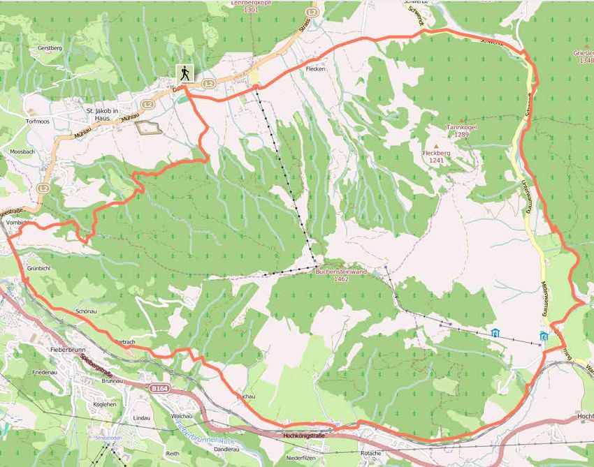
1    Bischof                                                                          29   Adolari-Runde

                       Fieberbrunn

                                                                                                       St. Ulrich am Pillersee
                                           2    Eiserne Hand - Burgeralm - Spielberg                                             30   Heimkehrerkreuz - Ulrichshorn
                                           3    Fieberbrunn Dorf - Buchensteinwand/Jakobskreuz                                   31   Kirchberg - Schafelberg
                                           4    Fieberbrunner Höhenweg                                                           32   Lindtalalm - Winterstelleralm
                                           5    Herrgott - Gebrakapelle - Gebragipfel                                            33   Pillerseerunde
                                           6    Karstein                                                                         34   Schießlingalm
                                           7    Schreiende Brunnen                                                               35   Teufelsklamm
                                           8    Wildalpgatterl - Jägersteig - Lärchfilzhochalm                                   36   Weiler Runde
                                           9    Wildseeloderhaus - Blumenweg Hochhörndl - Streuböden
                                           10   Fieberbrunn - Wildseeloderhaus - Wildseelodergipfel                              37   Blachholzkapelle - Enthgrieß - Hassler Schlucht

                                                                                                       Waidring
                                                                                                                                 38   Hackenschmiede - Schäferaukapelle - Kneippanlage
                                           11   Eggerbergweg                                                                     39   Rund um den Hausberg

                       Hochfilzen
                                           12   Grießner Almen                                                                   40   Triassic Trail - Steinplattengipfel
                                           13   Grießner Hochbrett                                                               41   Breitaualmen - Grießbachklamm
                                           14   Grießner Hochmoor                                                                42   Durchkaseralm - Fellhorn
                                           15   Hochfilzen Dorf - Buchensteinwand/Jakobskreuz                                    43   Wemeteigenalm - Steinplattengipfel
                                           16   Kirchl                                                                           44   Waidringer Panoramaweg
                                           17   Palfenweg                                                                        45   Weissbachschlucht
 Interaktive Karte                         18   Römer Sattel/Schüttachweg                                                        46   Weitwanderweg Waiwi
maps.pillerseetal.at                       19   Warminger Höhenweg
  interactive map                          20   Weitentalweg
                                           21   Eiblberg Einkehr - Bauernhof Gerstberg

                       St. Jakob in Haus
                                           22   Lehrbergalm - Schartenalm
                                           23   Panoramaweg St. Jakob in Haus
                                           24   St. Jakob in Haus - Fieberbrunn - St. Jakob in Haus
                                           25   St. Jakob in Haus - Jakobskreuz/Buchensteinwand
                                           26   St. Jakober Besinnungsweg
                                           27   St. Jakober Höhenweg
                                           28   Rundweg Buchensteinwand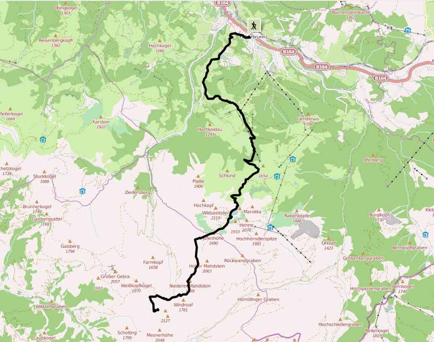
Fieberbrunn
Bischof 1
Startpunkt
Fieberbrunn Zentrum Höhendifferenz | altitude difference 1337 m
Höchster Punkt | highest point 2127 m
Streckenlänge | route lenght 14,3 km
Gehzeit | walking time 7:00 h
Schwierigkeit | difficulty schwierig/difficult
für Kinderwagen Wandernadel Einkehrmöglichkeit
for buggies hiking pin resting place
ü
Vom Dorf aus auf dem AV-Weg 711 über Rettenwand und Lucht From the village center take the path AV-711 via Rettenwand
bis zur Streuböden Alm. Nun zuerst zum Wildalpgatterl, dann and Lucht to the Streuböden Alm. First walk to the Wildalpgatterl
rechts über Kühweital zur Wildalm und weiter zum Wildseelo- and then right to the Wildalm and further on to the Wildsee-
derhaus. Dann über Seenieder (1.949 m) und den Niedermahd- loderhaus. Then via the Seenieder (1.949 m) and the Nieder-
stein (1.901 m) in Richtung Bischofsjoch und dann links haltend mahdstein (1.901m) in the direction Bischofsjoch. Then keep
auf den Gipfel. left towards the peak.
Mit Bergbahnbenutzung verkürzt sich die Gehzeit auf 4:00 h. By using the cable car the walking time will be reduced to 4 hours.
Fieberbrunn
Startpunkt
Gasthof Eiserne Hand Eiserne Hand - Burgeralm - Spielberg 2
Höhendifferenz | altitude difference 1252 m
Höchster Punkt | highest point 2044 m
Streckenlänge | route lenght 7,9 km
Gehzeit | walking time 4:00 h
Schwierigkeit | difficulty schwierig/difficult
für Kinderwagen Wandernadel Einkehrmöglichkeit
for buggies hiking pin resting place
ü ü
Vom Gasthof Eiserne Hand auf dem linken, leicht ansteigenden From the Gasthof Eiserne Hand continue further along the
Weg in ca. 2 Stunden bis zur Burgeralm. Dann weiter in nörd- slightly ascending path on the left to the Burgeralm, approxi-
licher Richtung zur Postmeisteralm und von hier auf dem gut matly 2 hours. Then in a northerly direction to the Postmeis-
markierten Weg über den Grat zum Gipfel (2.044 m). teralm and from here along the well marked trail to the peak
(2.044 m).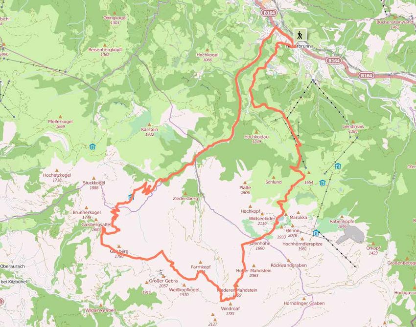
Fieberbrunn
Fieberbrunn Dorf - Buchensteinwand/Jakobskreuz 3
Höhendifferenz | altitude difference 666 m
Höchster Punkt | highest point 1456 m
Streckenlänge | route lenght 4,7 km
Gehzeit | walking time 2:00 h
Schwierigkeit | difficulty mittelschwierig/medium
für Kinderwagen Wandernadel Einkehrmöglichkeit
for buggies hiking pin resting place
ü ü
Vom Dorfzentrum von Fieberbrunn zum Feuerwehrhaus. Dort From the village center walk to the fire department. From here
links über die Brücke und weiter zum Weiler Schönau-Pertrach. turn left over the bridge and further to hamlet Schönau-Per-
Hier in nördlicher Richtung der Markierung bis zur Tennalm folgen. trach. Here continue in a northerly direction and follow the signs
Von der Tennalm führt der Steig in nordöstlicher Richtung zur to the Tennalm. From the Tennalm follow the ascending trail in
Startpunkt Buchensteinwand. a north-eastern direction to the Buchensteinwand.
Fieberbrunn Zentrum
Fieberbrunn
Fieberbrunner Höhenweg | high-level trail 4
Startpunkt Höhendifferenz | altitude difference 1170 m
Fieberbrunn Zentrum Höchster Punkt | highest point 1960 m
Streckenlänge | route lenght 30 km
Gehzeit | walking time 10:00 h
Schwierigkeit | difficulty mittelschwierig/medium
für Kinderwagen Wandernadel Einkehrmöglichkeit
for buggies hiking pin resting place
ü
Vom Dorf aus auf dem AV-Weg 711 über Rettenwand und Lucht From the village center take path AV-711 via Rettenwand and
bis zur Streuböden Alm. Nun zuerst zum Wildalpgatterl, dann Lucht to the Streuböden Alm. Carry on to the Wildalpgatterl,
rechts über Kühweital zur Wildalm und weiter zum Wildseeloder- then right to the Wildalm and up to the Wildseeloderhaus.
haus. Dann über Seenieder (1.949 m) und den Niedermahdstein Further on via Seenieder (1.949 m) and the Niedermahdstein
(1.901 m) bis zur nächsten Weggabel. Hier verlässt man den (1.901 m) to the next fork. Here you leave the AV-711 and take
AV-Weg und nimmt den rechts abbiegenden Weg zur Gebraka- the path to the right to the Gebrakapelle and to the Gebrajoch.
pelle/Gebrajoch. Weiter um den Gaisberggipfel zur Lengfilzenalm Continue to the Gaisberg Peak to Lengfilzenalm - Schlinachalm
- Schlinachalm - Grundalm vorbei am Almausschank Pletzer und - Lachtal - Grundalm and through the Pletzergraben via Al-
weiter durch den Pletzergraben zurück ins Dorf. Mit Bergbahnbe- mausschank Pletzer back to the village. By using the cable car
nutzung verkürzt sich die Gehzeit auf 7:00 h. the walking time will be reduced to 7 hours.
Fieberbrunn
Startpunkt
Gasthof Auwirt
Hergott - Gebrakapelle - Gebragipfel 5
Höhendifferenz | altitude difference 1429 m
Höchster Punkt | highest point 2057 m
Streckenlänge | route lenght 10,7 km
Gehzeit | walking time 4:00 h
Schwierigkeit | difficulty schwierig/difficult
für Kinderwagen Wandernadel Einkehrmöglichkeit
for buggies hiking pin resting place
ü ü
Auf dem Gebraweg in den Pletzergraben bis zum Almausschank Take the Gebraweg in the Pletzergraben to Almausschank
Pletzer. Von dort aus ca. 15 Minuten taleinwärts und über eine Pletzer. From here it takes approx. 15 min into the valley and
breite Brücke. Auf dem linken Weg weiter zu den Farmanger over a wide bridge. Take the left pathway to the Farmanger
Grundalmen und weiter bis zur Gebrakapelle. Von dort aus Grundalmen and further on to the Gebrakapelle. From here
rechts hinauf zur Gebrascharte und über den Gebraranken steil take the ascent on the right to the Gebrascharte and via the
aufwärts zum Gipfel (2.057 m). Gebraranken to the peak (2.057 m).
Fieberbrunn
Startpunkt
Gasthof Auwirt
Karstein 6
Höhendifferenz | altitude difference 1132 m
Höchster Punkt | highest point 1922 m
Streckenlänge | route lenght 8,5 km
Gehzeit | walking time 4:00 h
Schwierigkeit | difficulty mittelschwierig/medium
für Kinderwagen Wandernadel Einkehrmöglichkeit
for buggies hiking pin resting place
ü
Vom Gasthof Auwirt den Gebraweg entlang zur Abzweigung From Gasthof Auwirt walk along the Gebraweg to the junction
Richtung Hochkogl und auf dem Fahrweg bis zum Bauernhof in direction Hochkogl and take the street to the farm house
„Rohr“. Von da beginnt der Anstieg zum Karstein. Zuerst zu den „Rohr“. There the ascent to the Karstein begins. Continue to
oberen Edenhausalmen, weiter auf dem nordöstlich verlaufen- the upper pastures of the Edenhausalm, then further on via the
den Kamm zum Gipfel (1.922 m). northeast crest to the peak (1.922 m).
Fieberbrunn
Startpunkt
Schreiende Brunnen 7
Gasthof Eiserne Hand
Höhendifferenz | altitude difference 223 m
Höchster Punkt | highest point 1013 m
Streckenlänge | route lenght 2,7 km
Gehzeit | walking time 1:00 h
Schwierigkeit | difficulty leicht/easy
für Kinderwagen Wandernadel Einkehrmöglichkeit
for buggies hiking pin resting place
ü
Vom Gasthof Eiserne Hand weiter in den Hörndlinger Graben, Walk from the Gasthof Eiserne Hand along the Hörndlinger
über die Brücke, rechts entlang des Schwarzbaches zu den Graben over the bridge and right along the Schwarzbach to the
„Schreienden Brunnen“. Wer möchte, wandert weiter zu den „Schreiende Brunnen“. If you want, you can hike to the alpine
Almgründen im Hörndlinger Graben. pastures in the Hörndlinger Graben.
Fieberbrunn
Wildalpgatterl - Jägersteig - Lärchfilzhochalm 8
Startpunkt
Höhendifferenz | altitude difference 163 m
Mittelstation Streuböden
Höchster Punkt | highest point 1383 m
Streckenlänge | route lenght 2,5 km
Gehzeit | walking time 1:00 h
Schwierigkeit | difficulty leicht/easy
für Kinderwagen Wandernadel Einkehrmöglichkeit
for buggies hiking pin resting place
ü ü
Man fährt mit der Gondelbahn zur Mittelstation Streuböden. Take the cable car to the middle station „Streuböden“. Then
Dann wandert man den Fußweg entlang zum Wildalpgatterl und take the footpath to the Wildalpgatterl and left along the
links weiter auf dem Jägersteig zur Lärchfilzhochalm. Jägersteig to the Lärchfilzhochalm.Fieberbrunn
Wildseeloderhaus - Blumenweg Hochhörndl - Streuböden 9
Höhendifferenz | altitude difference 95 m
Höchster Punkt | highest point 1949 m
Streckenlänge | route lenght 7,8 km
Gehzeit | walking time 4:30 h
Schwierigkeit | difficulty mittelschwierig/medium
für Kinderwagen Wandernadel Einkehrmöglichkeit
for buggies hiking pin resting place
ü
Startpunkt
Wildseeloderhaus
Vom Wildseeloderhaus erreichen Sie über die Seenieder den From the Wildseeloderhaus via the Seenieder you reach the
wunderschönen Blumenweg mit zahlreichen unter Naturschutz wonderful Blumenweg (flower path), where you can see nume-
stehenden Alpenblumen. Die Wanderung wird über Reckmoos rous alpine flowers. After that you continue the tour via Hoch-
(Hochhörndler Hütte - nicht bewirtschaftet) und den Jägersteig hörndlhütte (not opened) and continue to Reckmoos and the
zur Mittelstation Streuböden fortgesetzt. Jägersteig to the middle-station Streuböden.Fieberbrunn
Fieberbrunn - Wildseeloderhaus - Wildseelodergipfel 10
Höhendifferenz | altitude difference 1498 m
Startpunkt Höchster Punkt | highest point 2219 m
Fieberbrunn Zentrum Streckenlänge | route lenght 9,7 km
Gehzeit | walking time 4:00 h
Schwierigkeit | difficulty schwierig/difficult
für Kinderwagen Wandernadel Einkehrmöglichkeit
for buggies hiking pin resting place
ü ü
Vom Dorf aus auf dem AV-Weg 711 über Rettenwand und Lucht From the village center take the path AV-711 via Rettenwand
bis zur Streuböden Alm. Nun zuerst zum Wildalpgatterl, dann and Lucht to the Streuböden Alm. First walk to the
rechts über Kühweital zur Wildalm und weiter zum Wildsee- Wildalpgatterl and then right to the Wildalm and further on to
loderhaus (Übernachtungsmöglichkeit). Vom Schutzhaus aus the Wildseeloderhaus. From the refuge the path leads along
führt der Weg rechtsseitig am See entlang, einen baumlosen the right side of the lake up to a treeless hillside and further
Hang hinauf und weiter der Seewand entlang, aufwärts zum along the „Seewand“ towards the Törl. Trough the jag and over
Törl. Durch diese Scharte und über einen sanften Rücken er- a soft ridge you reach the peak in approx. 45 min.
reicht man in ca. 45 Minuten den Gipfel.Hochfilzen
Eggerbergweg 11
Startpunkt
Hochfilzen Dorfzentrum Höhendifferenz | altitude difference 256 m
Höchster Punkt | highest point 1215 m
Streckenlänge | route lenght 8,7 km
Gehzeit | walking time 3:00 h
Schwierigkeit | difficulty mittelschwierig/medium
für Kinderwagen Wandernadel Einkehrmöglichkeit
for buggies hiking pin resting place
Vom Dorfzentrum wandern Sie vorbei an der Kirche, bis zur From the village center walk in direction Fieberbrunn and pass
ersten Abzweigung - Am Rossberg. Bei der Firma „Tyrolon“ ge- the church until you reach the first turn - „Am Rossberg“. At
radewegs bis zum Bauernhof „Schupfenboden“ und über den the company „Tyrolon“ walk straight ahead in direction farm
Wiesenweg bis Feistenau. Vor der Bushaltestelle folgen Sie Schupfenboden and Feistenau. Before the bus stop follow the
links der Straße nach Berglehen und weiter zur Aiblhöh. Vor road to the left in direction Berglehen and Aiblhöh. At the cattle
dem Viehgatter halten Sie sich links und folgen bergwärts dem gate keep left and follow the road uphill. From there via Wald-
Weg bis zur Anhöhe. Von dort gelangen Sie über die Waldmahd mahd and the forest road to the main road of Hochfilzen. Finally
und die Forststraße zur Bundsstraße. Von hier geht es linker turn left back to the village center of Hochfilzen.
Hand zum Ausgangspunkt zurück.Hochfilzen
Grießner Almen 12
Startpunkt
Hochfilzen Dorfzentrum
Höhendifferenz | altitude difference 403 m
Höchster Punkt | highest point 1362 m
Streckenlänge | route lenght 12,5 km
Gehzeit | walking time 4:00 h
Schwierigkeit | difficulty mittelschwierig/medium
für Kinderwagen Wandernadel Einkehrmöglichkeit
for buggies hiking pin resting place
ü
Vom Dorfzentrum wandern Sie die Bundesstraße entlang und From the village center walk along the main road and cross
überqueren die Landesgrenze Tirol-Salzburg (ca. 1,5 km ab the border Tyrol-Salzburg (1.5 km from Hochfilzen). Turn right
Hochfilzen). Biegen Sie beim Parkplatz rechts ab und folgen Sie at the parking and follow the forest trail up to Grießner Al-
dem Forstweg nach oben bis zu den Grießner Almen. Weiter men. Continue downhill to Aiblalm (Ulnalm) - then the way up
geht es leicht bergab zur Aiblalm (Ulnalm) - anschließend dem to Aiblhöhe. At the cattle gate keep right and follow the road
Weg nach oben bis zur Aiblhöhe folgend. Nach dem Viehgat- uphill. From there via Waldmahd and the forest road to the
ter halten Sie sich rechts und folgen dem Weg bergwärts bis main road of Hochfilzen. Finally turn left back to the village
zur Anhöhe. Von dort gelangen Sie über die Waldmahd und die center of Hochfilzen.
Forststraße zur Bundsstraße. Von hier geht es linker Hand Rich-
tung Dorfzentrum Hochfilzen zurück.Hochfilzen
Grießner Hochbrett 13
Höhendifferenz | altitude difference 1511 m
Höchster Punkt | highest point 2470 m
Streckenlänge | route lenght 7,7 km
Gehzeit | walking time 4:30 h
Schwierigkeit | difficulty schwierig/difficult
für Kinderwagen Wandernadel Einkehrmöglichkeit
for buggies hiking pin resting place
Startpunkt
Hochfilzen Regio-Tech
Der Anstieg führt vom „Regio-Tech“ zunächst über die Reche- The hike starts at the „Regio-tech“ first over the Recheralm
ralm - Willegghöh bis zur Grießner Schafalm (1.508 m). Nun - Willegghöh to Grießener Schafalm (1.508 m). Now we ad-
halten wir uns nordöstlich, gelangen über einen Waldrücken here to the northeast, get over a forest back to Hochdrachkopf
zum Hochdrachkopf (1.722 m), weiter durch eine Latschenzone (1.722 m), on through a mountain pine zone to the Jungfrau
zur Jungfrau (1.910 m) und über den markanten Rücken zum (1.910 m) and further on to the Grießener Rotschartl (2.320 m).
Grießener Rotschartl (2.320 m). Von dort zunächst leicht abstei- From there slightly descending towards the southwest, then
gend, Richtung SW, dann an der W-Seite immer unterhalb des at the west-side always below the ridge on the tapes, good
Grates über Bänder, gute Steigspuren und der Seilversicherung climbing tracks and an insurance rope to the ridge. Then the
zum Grat und die letzten Meter zum Gipfelkreuz. last few meters to the summit.Hochfilzen
Grießner Hochmoor 14
Höhendifferenz | altitude difference 31 m
Höchster Punkt | highest point 990 m
Streckenlänge | route lenght 2,3 km
Gehzeit | walking time 2:00 h
Startpunkt
Hochfilzen Dorfzentrum Schwierigkeit | difficulty leicht/easy
für Kinderwagen Wandernadel Einkehrmöglichkeit
for buggies hiking pin resting place
ü ü
Landschafts- und Vogelschutzgebiet Bird observation area
Eine Wanderung zum Grießensee führt von Hochfilzen auf dem A hike to the romantic Grießensee leads you from the railway
Radweg Richtung Leogang zum Vogelbeobachtungsturm direkt underpass to the Magnesitstraße. Turn right onto the bike path
am See. Unzählige Vogelarten brüten am Grießner Hochmoor to Leogang. Pass the reed zone to the bird observation tower
und können beobachtet werden. Vor allem in der Morgensonne directly at the lake. Countless types of birds can be observed.
vermutet man sich eher am Neusiedler See als im Gebirge.Hochfilzen
Hochfilzen Dorf - Buchensteinwand/Jakobskreuz 15
Höhendifferenz | altitude difference 497 m
Höchster Punkt | highest point 1456 m
Streckenlänge | route lenght 3,3 km
Gehzeit | walking time 2:00 h
Schwierigkeit | difficulty mittelschwierig/medium
für Kinderwagen Wandernadel Einkehrmöglichkeit
for buggies hiking pin resting place
ü
Startpunkt ist der Parkplatz bei der Talstation des Schleppliftes Start at the parking of the lift-station in direction of Untertenn.
in Richtung Untertenn. Entweder wandern Sie querfeldein rechts On the right the steep trail leads directly to the top (or before
beim Wegweiser über die Almwiesen oder über den Kammberg- Obertenn, follow the Kammberg path on the left side and walk
weg bis zur Hoametzlhütte und weiter bis zur Buchensteinwand. via the Hoametzlhütte up to the peak).
Startpunkt
Schlepplift TalstationHochfilzen
Kirchl 16
Höhendifferenz | altitude difference 721 m
Höchster Punkt | highest point 1680 m
Streckenlänge | route lenght 2,8 km
Gehzeit | walking time 2:00 h
Schwierigkeit | difficulty mittelschwierig/medium
für Kinderwagen Wandernadel Einkehrmöglichkeit
for buggies hiking pin resting place
ü
In Oberwarming nach der Brücke rechts ca. 300 m bachauf- From Oberwarming walk approx. 300 m on to the circular trail
wärts den Forstweg folgen, bei der ersten Weggabelung links Buchensteinwand, then to the right. It‘s a steep ascent to the
halten und nach dem ersten kurzen Anstieg rechts querfeldein top and the trail leads directly to the peak. If the weather is fine,
dem Wanderweg folgen. Der letzte Abschnitt erfolgt steil zum you can see 7 churchtowers!
Gipfel (festes Schuhwerk unbedingt erforderlich).
Startpunkt
Hochfilzen WarmingHochfilzen
Palfenweg 17
Höhendifferenz | altitude difference 182 m
Höchster Punkt | highest point 1141 m
Streckenlänge | route lenght 4,4 km
Gehzeit | walking time 2:00 h
Schwierigkeit | difficulty mittelschwierig/medium
für Kinderwagen Wandernadel Einkehrmöglichkeit
for buggies hiking pin resting place
Ausgehend vom Parkplatz Barbarakapelle gehen Sie vorbei am Starting from the parking „Barbarakapelle“ you pass the com-
Kommandogebäude. Bei der ersten Abzweigung wandern Sie mand building. At the first fork turn left and hike uphill staying
Startpunkt links bergwärts der Forststraße entlang. 200 m nach der Alm- on the forest road. 200 m after the hut follow the signs towards
Parkplatz Barbarakapelle hütte folgen Sie dem Wegweiser talwärts. Über Wiesen- und to the Liedlgraben. From there follow the forest trail along the
Waldwege gelangen Sie zum Liedlgraben. Hier folgen Sie dem small river. At the bridge turn left and go back to the starting
Forstweg entlang des Baches. Bei der Brücke links durch die point.
Warmingerstraße zurück zum Ausgangspunkt.Hochfilzen
Römer Sattel/Schüttachweg 18
Höhendifferenz | altitude difference 246 m
Höchster Punkt | highest point 1205 m
Streckenlänge | route lenght 12,8 km
Gehzeit | walking time 4:00 h
Schwierigkeit | difficulty mittelschwierig/medium
für Kinderwagen Wandernadel Einkehrmöglichkeit
for buggies hiking pin resting place
ü
Diese Wanderung führt über den Römersattel auf dem alten This walk leads you via the Römersattel on the old pilgrim
Wallfahrtsweg in das Pinzgau. Ausgehend vom Ortszentrum trail into the Pinzgau. Start in the center of Hochfilzen, walk
Hochfilzen wandern Sie Richtung Truppenübungsplatz, vorbei in direction of the Troop Practice Range (TÜPL) and pass the
an der Biathlonanlage, Richtung Römersattel (1.205 m) bis zur Biathlon-stadium in direction of the Römersattel (1.205m) to
Startpunkt Vorderkaserklamm (Einkehrmöglichkeit). the Vorderkaserklamm (possibility to rest).
Hochfilzen Dorfzentrum
Dieser Weg führt durch militärisches Sperrgebiet. Bitte auf Hin- This path leads through military zone. Please refer to the signs
weis- und Verbotstafeln unbedingt achten! Rückfahrt mit dem next to the path! From Saalfelden you can take the bus back
Postbus über Saalfelden. to Hochfilzen.Hochfilzen
Warminger Höhenweg | Warminger high-level trail 19
Höhendifferenz | altitude difference 351 m
Höchster Punkt | highest point 1310 m
Streckenlänge | route lenght 7,1 km
Gehzeit | walking time 3:00 h
Schwierigkeit | difficulty mittelschwierig/medium
für Kinderwagen Wandernadel Einkehrmöglichkeit
for buggies hiking pin resting place
In Oberwarming nach der Brücke rechts ca. 300 m bachauf- After the bridge follow the forest road upstream for about 300
wärts den Forstweg folgen, bei der ersten Weggabelung links meters - at the first junction turn left and after the first descend
halten und nach dem ersten kurzen Anstieg rechts querfeldein follow the trail keeping right. At the top turn left and walk on
dem Wanderweg folgen. Oben auf dem Hüttenboden angekom- until reaching the Wiesensee. From here walk on the circular
men biegen Sie links ab und wandern weiter bis zum Wiesen- trail back to the starting point.
Startpunkt
see. Von hier aus geht es auf dem Rundweg wieder zurück zum
Hochfilzen Warming
Ausgangspunkt.Hochfilzen
Startpunkt
Hochfilzen Ortsende
Weitentalweg 20
Höhendifferenz | altitude difference 92 m
Höchster Punkt | highest point 1051 m
Streckenlänge | route lenght 6,4 km
Gehzeit | walking time 2:00 h
Schwierigkeit | difficulty leicht/easy
für Kinderwagen Wandernadel Einkehrmöglichkeit
for buggies hiking pin resting place
Vom Ortszentrum wandern Sie ostwärts der Bundesstraße ent- From the village center walk in eastern direction along the
lang bis zur Landesgrenze. Hier folgen Sie rechts der Forst- main road to the border Tyrol-Salzburg. Here you turn right and
straße bergwärts bis zur ersten Gabelung. Hier folgen Sie dem follow the forest road uphill to the first fork. From there follow
Wegweiser Richtung Feistenau. Über einen schmalen Wald- the signs to Feistenau. Over a narrow forest path and further
weg gelangen Sie auf einen Forstweg zur Hoferbrücke. Von on to the Hoferbrücke (bridge) - to the right and further on to
hier aus rechts bis zur Bundesstraße und Richtung Hochfil- the main road. From there walk in direction Hochfilzen. From
zen den Gehsteig entlang. Bei Bindermoos gelangen Sie über Bindermoos you walk back via Schupfenboden to the starting
Schupfenboden zum Ausgangspunkt zurück. point.St. Jakob in Haus
Eiblberg Einkehr - Bauernhof Gerstberg 21
Höhendifferenz | altitude difference 264 m
Höchster Punkt | highest point 1119 m
Streckenlänge | route lenght 2,5 km
Gehzeit | walking time 1:30 h
Schwierigkeit | difficulty leicht/easy
für Kinderwagen Wandernadel Einkehrmöglichkeit
Startpunkt for buggies hiking pin resting place
St. Jakob Dorfzentrum ü
Zwischen Gasthof Post und Gemeindeamt geht es die Pfarr- Between Gasthof Post and Gemeindeamt you follow the Pfarr-
gasse entlang bis zum Pfarrhaus. Anschließend führt der Weg gasse to the Pfarrhaus. Then the trail leads right up over the
rechts hoch über den Eiblberg. In ca. 45 min. erreichen Sie die Eiblberg. In about 45 min. you will reach the Jausenstation
Jausenstation Eiblberg Einkehr. Ab hier können Sie den Weg Eiblberg. From here you can continue to the 700 year old farm
zum 700 Jahre alten Bauernhof Gerstberg (1.119 m - nicht Gerstberg (not opended) at an altitude of 1.119 m.
bewirtschaftet) fortsetzen.St. Jakob in Haus
Lehrbergalm - Schartenalm 22
Höhendifferenz | altitude difference 559 m
Höchster Punkt | highest point 1414 m
Streckenlänge | route lenght 3,0 km
Gehzeit | walking time 2:00 h
Schwierigkeit | difficulty mittelschwierig/medium
für Kinderwagen Wandernadel Einkehrmöglichkeit
for buggies hiking pin resting place
ü
Beim Bauernhof Lehrberg (Nähe Bushaltestelle) vorbei, gerade- Starting point: Weiler Lehrberg, pass the farmhouse Lehrberg
Startpunkt aus dem Wegweiser folgend bis zur Lehrbergalm. Dort ange- (close to the bus stop) and walk straight ahead following the
Bauernhof Lehrberg kommen stehen 2 Wandervarianten zur Auswahl: die leichtere sign to the Lehrbergalm. There you have two hiking possibili-
Variante über den Forstweg oder den etwas schwierigeren Hö- ties to choose from: the easier option via the forest track or the
henwanderweg durch den Hochwald zur Schartenalm. more difficult path via the high forest to the Schartenalm.Startpunkt
St. Jakob in Haus
Gasthof Post Panoramaweg St. Jakob in Haus | panorama trail St. Jakob in Haus 23
Höhendifferenz | altitude difference 115 m
Höchster Punkt | highest point 970 m
Streckenlänge | route lenght 6,8 km
Gehzeit | walking time 3:00 h
Schwierigkeit | difficulty leicht/easy
für Kinderwagen Wandernadel Einkehrmöglichkeit
for buggies hiking pin resting place
ü ü
Beim Gasthof Post wandert man links Richtung Pension Elisa- At Gasthof Post walk left towards Pension Elisabeth. Then right
beth. Danach geht es rechts weiter zum Sportplatz, weiter links to the sports field, further to the left in the direction of Flecken
Richtung Flecken bis zum Kröpfllift. Am Kröpflliftstüberl vorbei to the junction at the Kröpfllift. Towards Buchsteinwand to the
bis zum Wegweiser Panoramaweg Fieberbrunn. Auf diesem signpost saying “Panoramaweg Fieberbrunn”. In this direction
Weg erreicht man den Rundweg Buchensteinwand. Über Hoch- you reach the circle trail “Buchsteinwand”. Follow the descen-
egg bis zum Wegweiser Moosbach. Weiter auf dem Holzerweg ding trail to the signpost saying “Moosbach”. Next on the Hol-
bis zum Weiler Moosbach. Dann in rechter Richtung die Piller- zerweg to the hamlet of Moosbach. Then in the right direction
see Landesstraße entlang. Nach ca. 200m die Landesstraße along the Pillersee road. After about 200m cross the road and
überqueren und weiter zum Weiler Filzen und über den Panora- walk up to the hamlet Filzen and on the Panoramaweg back to
maweg zurück in das Dorfzentrum. the village center.St. Jakob in Haus
St. Jakob in Haus - Fieberbrunn - St. Jakob in Haus 24
Höhendifferenz | altitude difference 62 m
Startpunkt
Höchster Punkt | highest point 917 m
St. Jakob Dorfzentrum
Streckenlänge | route lenght 8 km
Gehzeit | walking time 3:00 h
Schwierigkeit | difficulty leicht/easy
für Kinderwagen Wandernadel Einkehrmöglichkeit
for buggies hiking pin resting place
ü ü ü
Vom Dorfzentrum entlang des Besinnungsweges bis zur Stati- From the village center on the “Besinnungsweg” to the station
on Pilgerstab. Dann geht es weiter in linker Richtung über den “Pilgerstab”. Then you continue to the left on the trail Buch-
Rundweg Buchensteinwand bis zur Pillersee-Landesstraße. Die steinwand to the Pillersee main road. Cross the main road,
Landesstraße überqueren und dann weiter auf dem Rundweg staying on the circle trail to „Kühle Klause“. Above the farm
bleibend zur „Kühlen Klause“. Oberhalb des Bauernhofes Hoch- Hochegg follow the trail until the railway underpass Vornbichl.
egg bis zur Bahnunterführung Vornbichl. Nach dieser geradeaus Then via Rosenegg to the railway station Fieberbrunn and back
bergab zum Ortsteil Rosenegg, weiter zum Bahnhof Fieberbrunn over Torfmoos and Filzen to St. Jakob in Haus.
und zurück über Torfmoos – Filzen nach St.Jakob in Haus.St. Jakob in Haus
St. Jakob in Haus - Buchensteinwand/Jakobskreuz 25
Startpunkt
St. Jakob Dorfzentrum Höhendifferenz | altitude difference 607 m
Höchster Punkt | highest point 1462 m
Streckenlänge | route lenght 4,7 km
Gehzeit | walking time 2:00 h
Schwierigkeit | difficulty mittelschwierig/medium
für Kinderwagen Wandernadel Einkehrmöglichkeit
for buggies hiking pin resting place
ü ü
Vom Dorfzentrum geht es ein kurzes Stück Richtung Bergbahn From the center of St. Jakob in Haus you walk in direction
Pillersee. Bei der Pension Elisabeth rechts hinunter, am Fußball- Bergbahn Pillersee (cable car station). At Pension Elisabeth you
platz vorbei und weiter entlang des Rundweges Buchenstein- turn right, pass the football field and keep going along the cir-
wand Richtung Fieberbrunn. An der nächsten Abzweigung links cular path Buchsteinwand in direction Fieberbrunn. At the next
und über Katzeneck / Kühle Klause Richtung Buchensteinwand. junction turn left in direction Buchensteinwand via Katzeneck /
Unterhalb des Gipfels wieder links und das letzte Stück über die Kühle Klause. Below the summit turn left and keep going up to
Wiese gerade hinauf zur Buchensteinwand und zum Alpengast- the Buchensteinwand and the alpine inn “Buchensteinwand”.
hof Buchensteinwand. Auf dem Plateau können Sie das Jakobs- On the plateau you can visit the Jakobskreuz, the flower trail
kreuz, den Blumenlehrpfad und den Speichersee besichtigen. and the reservoir lake.St. Jakob in Haus
St. Jakober Besinnungsweg | St. Jakober path of senses 26
Startpunkt Höhendifferenz | altitude difference 0m
St. Jakob Dorfzentrum Höchster Punkt | highest point 857 m
Streckenlänge | route lenght 1,3 km
Gehzeit | walking time 0:45 h
Schwierigkeit | difficulty leicht/easy
für Kinderwagen Wandernadel Einkehrmöglichkeit
for buggies hiking pin resting place
ü ü
Ein Teil des Jakobsweges führt durch St. Jakob in Haus, wo A part of the Pilgrim’s Route leads through St. Jakob in Haus.
anlässlich des 700-Jahr-Jubliäums der Gemeinde St. Jakob During the 700th anniversary of St.Jakob in Haus the idea was
in Haus die Idee eines Besinnungsweges entstand. Beginnend raised, to build a path of senses. Starting at the fountain in
beim Brunnen vor der Kirche zum Hl. Jakobus finden Sie die front of the church you find the symbols of the patron Saint
Symbole des Schutzpatrons wie Muschel, Stab und Hut, die Jacob: shell, wand and hat. The trail provides a unique oppor-
zum Verweilen am Wegesrand einladen. tunity for reflection.St. Jakob in Haus
St. Jakober Höhenweg | St. Jakober high-level trail 27
Höhendifferenz | altitude difference 62 m
Höchster Punkt | highest point 917 m
Streckenlänge | route lenght 8,0 km
Gehzeit | walking time 4:00 h
Schwierigkeit | difficulty mittelschwierig/medium
für Kinderwagen Wandernadel Einkehrmöglichkeit
for buggies hiking pin resting place
ü ü
Vom Gasthof Post in westlicher Richtung nach Filzen – Obwall, From Gasthof Post go in a westerly direction to Filzen – Obwall.
an Bauernhöfen vorbei bis zur Weggabelung Fieberbrunn – Cross the farms until the fork Fieberbrunn - Hochreith. Turn
Startpunkt Hochreith. Allerdings nicht links über das Bachbett, sondern right towards Tennhäusl and then to the 700 year old farm
Gasthof Post rechts ab in Richtung Tennhäusl und weiter zum 700 Jahre Gerstberg. Next to the Hauserberg (Here you have the option to
alten Bauernhof Gerstberg. Weiter bis zum Hauserberg (Hier use the trail over the Eiblberg to Filzen or you take the descen-
hat man die Möglichkeit über den Eiblberg nach Filzen oder ding trail directly to St. Jakob in Haus). Next on the “Steinerne
direkt nach St. Jakob in Haus abzusteigen). Weiter über die Stiege” to the Schartenbergalm and Lehrbergalm. From the
Steinerne Stiege zur Schartenbergalm und Lehrbergalm. Von Lehrbergalm there are two options: to the Lehrbergbauer or to
der Lehrbergalm gibt es 2 Abstiegsmöglichkeiten: Entweder the village of St. Jakob in Haus.
zum Lehrbergbauern oder nach St. Jakob in Haus Dorfzentrum.St. Jakob in Haus
Rundweg Buchensteinwand | circular walk Buchensteinwand 28
Startpunkt
St. Jakob in Haus
Der Einstieg ist von allen Höhendifferenz | altitude difference 171 m
Orten im PillerseeTal Höchster Punkt | highest point 1018 m
möglich Streckenlänge | route lenght 20,0 km
Gehzeit | walking time 5:00 h
Schwierigkeit | difficulty mittelschwierig/medium
für Kinderwagen Wandernadel Einkehrmöglichkeit
for buggies hiking pin resting place
ü ü
Vom Dorfzentrum St. Jakob in Haus aus rechts entlang der Lan- Starting point is the village center of St. Jakob in Haus. From
desstraße Richtung St. Ulrich am Pillersee, an der Bergbahn there right beside of the main road towards St. Ulrich am Piller-
Pillersee vorbei und weiter zum Ortsteil Flecken. Vor dort aus see. Pass the Bergbahn Pillersee and the district Flecken. From
geht‘s rechts weiter Richtung Wiesensee. Anschließend weiter there, you go right along a forest trail in direction Wiesensee.
Richtung Hochfilzen, beim Glaagut rechts abbiegen und nach Then continue towards Hochfilzen, turn right at Glaagut and
der Brücke links in Richtung Fieberbrunn/Pfaffenschwendt. then left after the bridge. Then walk in the direction of Fieber-
Oberhalb der Bahnstrecke über Buchau und Schönau-Pertrach brunn / Pfaffenschwendt and above the railway to Vornbichl.
nach Vornbichl. Von dort etwas steil bergauf nach Hochegg, From there, a bit steep uphill to Hochegg, then to „Kühle Klau-
weiter zur „Kühlen Klause“ und entlang des Rettenbachs hinun- se“ and along the Rettenbach down to the hamlet Mühlau and
ter zum Ortsteil Mühlau und zurück zum Ausgangspunkt. back to St. Jakob in Haus.St. Ulrich am Pillersee
Adolari-Runde | Adolari circular walk 29
Höhendifferenz | altitude difference 100 m
Höchster Punkt | highest point 913 m
Streckenlänge | route lenght 8,2 km
Gehzeit | walking time 2:30 h
Schwierigkeit | difficulty leicht/easy
für Kinderwagen Wandernadel Einkehrmöglichkeit
for buggies hiking pin resting place
ü
Von der Pfarrkirche in Richtung Latschenbad, dann rechts zum From the church walk in direction Latschenbad, then right to
Panoramaweg nach St. Adolari. Die Kreuzwegstationen leiten the Panorama trail to St. Adolari. The path, with stations of
die Wanderer bis hin zur bekannten Wallfahrtskirche und dem the cross, leads hikers to the well known pilgrimage church
Gasthof St. Adolari. Für den Rückweg muss in Richtung Waidring to Gasthof St. Adolari. Coming back, cross the Pillersee street
die Pillersee-Landesstraße überquert werden, danach führt der - after the wide walking path meets the Pillersee path - walk
breite Wander- und Radweg, der dann auf die Pillerseerunde past the kiosk back to St. Ulrich am Pillersee.
Startpunkt trifft, am Kiosk vorbei, retour nach St. Ulrich am Pillersee.
PfarrkircheSt. Ulrich am Pillersee
Heimkehrerkreuz - Ulrichshorn 30
Höhendifferenz | altitude difference 1183 m
Höchster Punkt | highest point 2030 m
Streckenlänge | route lenght 3,8 km
Gehzeit | walking time 3:00 h
Schwierigkeit | difficulty schwierig/difficult
für Kinderwagen Wandernadel Einkehrmöglichkeit
for buggies hiking pin resting place
Startpunkt Achtung: Nur mit Bergerfahrung! Attention: experienced hikers only!
St. Ulrich am Pillersee
Dorf Ausgehend vom Parkplatz Dorf/Pillersee auf dem Steg den From the „Dorf/Pillersee parking“ cross the footbridge over
kleinen Bach überqueren, geradeaus weiter, dann beginnt der the small river. Walk straight ahead and up the winding trail to
Anstieg über den serpentinenartigen Steig zur Bräuplatte in the Bräuplatte at 1.430m. From there walk through the alpine
1.430 m Höhe. Von dort geht es durch die Latschen steil berg- pines up to the rocks of the Steinberge in order to reach the
auf zu den Felsen der Steinberge, um das Heimkehrerkreuz/ Heimkehrerkreuz/Ulrichshorn.
Ulrichshorn zu erreichen.St. Ulrich am Pillersee
Kirchberg - Schafelberg 31
Höhendifferenz | altitude difference 831 m
Höchster Punkt | highest point 1680 m
Streckenlänge | route lenght 6,8 km
Gehzeit | walking time 3:00 h
Schwierigkeit | difficulty mittelschwierig/medium
für Kinderwagen Wandernadel Einkehrmöglichkeit
for buggies hiking pin resting place
ü
Ausgehend vom Latschenbad geht es über die spektakuläre From the Latschenbad walk via the spectacular „Steinere Stie-
Steinere Stiege durch das sogenannte Kalktal zum Gipfel des ge“ through the so-called Kalktal (Lime Valley) to the peak of
Kirchbergs mit 1.680 m Höhe und von dort weiter zum Schafel- the Kirchberg at an altitude of 1.680m. From there further on
berg, 1.597 m hoch. Der kürzere, aber sehr steile Abstieg führt to the Schafelberg (1.597m). The short but very steep descent
über den Teufelspalfen direkt zurück zum Latschenbad. leads over the Teufelspalfen directly back to the Latschenbad.
Startpunkt Kondition, Trittsicherheit sowie Schwindelfreiheit von Nöten! Very good physical constitution, endurance, free from vertigo
Latschenbad (Ausgesetzte Stellen, Seilsicherungen, etc.) and safe over steep terrain is necessary.St. Ulrich am Pillersee
Lindtalalm - Winterstelleralm 32
Startpunkt
Schartental bzw. Höhendifferenz | altitude difference 873 m
Latschenbad
Höchster Punkt | highest point 1423 m
Streckenlänge | route lenght 4,3 km
Gehzeit | walking time 1:30 h
Schwierigkeit | difficulty mittelschwierig/medium
für Kinderwagen Wandernadel Einkehrmöglichkeit
for buggies hiking pin resting place
ü ü
Entweder von Schartental ausgehend entlang des Fahrweges From Schartental walk along the street or take the hiking trail
oder ab dem Latschenbad über den Wandersteig. Zuerst er- from the Latschenbad. You‘ll reach the Lindtalalm first, at
reichen Sie die Lindtalalm (1.087 m), von dort geht es in einer 1.087m. From here it takes one more hour up to the Winter-
weiteren Stunde hoch zur Winterstelleralm (1.420 m). stelleralm at an altitude of 1.423 m.St. Ulrich am Pillersee
Pillerseerunde | circular walk Pillersee 33
Höhendifferenz | altitude difference 61 m
Höchster Punkt | highest point 908 m
Streckenlänge | route lenght 4,4 km
Gehzeit | walking time 1:30 h
Schwierigkeit | difficulty leicht/easy
für Kinderwagen Wandernadel Einkehrmöglichkeit
for buggies hiking pin resting place
ü ü
Dieser Spaziergang startet beim Parkplatz Dorf/Pillersee, bie- From the „Dorf/Pillersee parking“ turn left to the path that
gen Sie links ab und folgen Sie dem Spazierweg der rechten leads along the right side of the lake. After the kiosk walk over
Seeseite entlang. Nach dem Kiosk gehen Sie über einen kleinen the small footbridge to the other side of the lake. Continue on
Steg auf die gegenüberliegende Seite, am Restaurant Pillersee passing the restaurant Pillersee before returning to the parking
vorbei zurück zum Ausgangspunkt. Dorf/Pillersee.
Startpunkt
Parkplatz DorfSt. Ulrich am Pillersee
Schießlingalm 34
Höhendifferenz | altitude difference 492 m
Höchster Punkt | highest point 1307 m
Streckenlänge | route lenght 2,8 km
Gehzeit | walking time 1:30 h
Schwierigkeit | difficulty mittelschwierig/medium
für Kinderwagen Wandernadel Einkehrmöglichkeit
for buggies hiking pin resting place
ü ü
Startpunkt
Weißleiten
In Weißleiten zuerst in Richtung Grieseltal, dann hinauf auf dem From Weißleiten walk in the direction of Grieseltal. Then up on
gut markiertem Weg zur Schießlingalm (1.270 m) den Steinber- the well marked trail to the Schießlingalm,(1.270m), located in
gen vorgelagert. front of the Steinberge.St. Ulrich am Pillersee
Startpunkt
Parkplatz Teufelsklamm
Teufelsklamm 35
Höhendifferenz | altitude difference 121 m
Höchster Punkt | highest point 968 m
Streckenlänge | route lenght 1,0 km
Gehzeit | walking time 1:00 h
Schwierigkeit | difficulty leicht/easy
für Kinderwagen Wandernadel Einkehrmöglichkeit
for buggies hiking pin resting place
ü
Der Parkplatz befindet sich direkt vor der Teufelsklamm. Ab hier Possibility to park directly infront of the Teufelsklamm. From
folgt man den Wegweisern „Teufelsklamm“ und wandert scharf here follow the sign-posts „Teufelsklamm“ foot-path into the
nach Osten auf dem Forstweg aufwärts. Nach etwa 400 m biegt gorge. At the end a little devil‘s figure awaits you. The tour
man links ab und folgt einem markierten Fußweg in die Klamm. takes app. 40 min upwards and 30 min towards.Please wear
Von der Brücke hat man einen schönen Blick in die Klamm, der good shoes!
Teufel grüßt Sie aus einer Felsnische! Für die Wanderung sind
etwa 40 Minuten Aufstieg und ca. 30 Minuten Abstieg einzupla- Open in Summer without fee!
nen. Trittsicherheit und gutes Schuhwerk ist unbedingt erforder-
lich, besonders bei nassem und somit rutschigem Untergrund!St. Ulrich am Pillersee
Weiler Runde | circular walk 36
Startpunkt
Parkplatz Dorf
Höhendifferenz | altitude difference 63 m
Höchster Punkt | highest point 910 m
Streckenlänge | route lenght 7,1 km
Gehzeit | walking time 2:30 h
Schwierigkeit | difficulty leicht/easy
für Kinderwagen Wandernadel Einkehrmöglichkeit
for buggies hiking pin resting place
ü ü
Ausgangspunkt vom Parkplatz Dorf/Pillersee auf dem Steg From the „Dorf/Pillersee parking“ cross the footbridge over the
den kleinen Bach überqueren, geradeaus weiter, dann geht es small river and walk straight on. Then the trail leads right be-
rechts hinter Neuwieben in Richtung Weißleiten, im Bereich des hind Neuwieben in the direction of Weißleiten. In the area of the
Koglfasserwegs zum Weiler Au abzweigen, um von dort zum Koglfasser path take the forked path to Weiler Au and from the-
Strasserwirt zu gelangen. Dananch von Strass aus über den re you‘ll reach the Strasserwirt. After Strass take the walking/
Rad- und Wanderweg zurück in das Dorfzentrum von St. Ulrich bike path back into the village center of St. Ulrich am Pillersee.
am Pillersee.Waidring
Blachholzkapelle - Enthgrieß - Hassler Schlucht 37
Höhendifferenz | altitude difference 90 m
Höchster Punkt | highest point 937 m
Streckenlänge | route lenght 11,0 km
Gehzeit | walking time 3:00 h
Schwierigkeit | difficulty mittelschwierig/medium
für Kinderwagen Wandernadel Einkehrmöglichkeit
for buggies hiking pin resting place
ü
Vom Dorf in Richtung Brennerei Brandtner, von dort links auf From the village center walk to the Brennerei Brandtner and
den Wiesenweg zur Blachholzkapelle und weiter dem Spazier- turn left. Via the Wiesenweg to the Blachholz Chapel and then
Startpunkt
weg folgend bis zum Genussladen Seibl (Einkehrmöglichkeit). further to the Genussladen Seibl (possibility to rest). From there
Waidring Dorf
Von dort aus geht‘s übers Reiterdörfl ins Mühltal und hinein in you continue via the Reiterdörfl to the Mühltal and into the wild
die wild romantische Hasslerschlucht bis zum Wasserfall und romantic Hasslerschlucht to the waterfall. Take the same way
auf dem gleichen Weg wieder zurück zum Genussladen Seibl back to the Genussladen Seibl and via the walking path back
und über den Rad-/Wanderweg retour ins Dorf. to the village center.Waidring
Hackenschmiede - Schäferaukapelle - Kneippanlage 38
Startpunkt
Waidring Dorfzentrum
Höhendifferenz | altitude difference 44 m
Höchster Punkt | highest point 822 m
Streckenlänge | route lenght 6,9 km
Gehzeit | walking time 2:00 h
Schwierigkeit | difficulty leicht/easy
für Kinderwagen Wandernadel Einkehrmöglichkeit
for buggies hiking pin resting place
ü
Vom Dorf in Richtung Pillersee dem Achenweg (links) entlang From the village center walk in direction of the Pillersee along
bis zum Mühlrad der alten Hackenschmiede, über das „Pfarrer- the Achenweg (left) all the way to the mill wheel of the old
steigl“ zur Schäferaukapelle, von dort zur Kneippanlage/Seisen- Hackenschmiede. Via the „Pfarrersteigl“ to the Schäferau Cha-
bachquelle und zurück über den Ortsteil Unterwasser. pel. From there along the mountain side to the Kneippanlage/
Seisenbachquelle and back via district of Unterwasser.Startpunkt
Waidring
Waidring Dorfzentrum Rund um den Hausberg | circular walk Hausberg 39
Höhendifferenz | altitude difference 211 m
Höchster Punkt | highest point 989 m
Streckenlänge | route lenght 6,2 km
Gehzeit | walking time 2:00 h
Schwierigkeit | difficulty mittelschwierig/medium
für Kinderwagen Wandernadel Einkehrmöglichkeit
for buggies hiking pin resting place
ü ü
Vom Dorfzentrum (bei Hausberg-Schlefpplift) dem Weg bis zum The starting point is the village center (Hausberg T-bar). Follow
Brunnen folgen. Dann weiter links dem Wanderweg folgend this path to the fountain, then turn left above the Weissbach
oberhalb der Weissbachschlucht bis zum Forstweg Talsenalm, gorge to the forest trail to Talsenalm. Stay right and walk to-
rechtshaltend dann zur Talsenalm, weiter zum Krinnsattel und wards Talsenalm and further on to the Krinnsattel and back to
nach Waidring retour. Variante: vom Krinnsattel rechts hoch zum Waidring. Option: From the Krinnsattel ascend right up to the
Hausberg Gipfel und vorne wieder ins Tal zum Brunnen. Hausberg peak. Return to the valley by the fountain.Waidring
Startpunkt
Bergstation Steinplatte
Triassic Trail - Steinplattengipfel 40
Höhendifferenz | altitude difference 209 m
Höchster Punkt | highest point 1869 m
Streckenlänge | route lenght 3,9 km
Gehzeit | walking time 1:30 h
Schwierigkeit | difficulty leicht/easy
für Kinderwagen Wandernadel Einkehrmöglichkeit
for buggies hiking pin resting place
ü ü ü
Der Triassic Trail führt vom Park zur Aussichtsplattform, von der From the top station of the cable car walk in direction of the
aus man das herrliche Panorama bewundern kann. Weiter geht peak. After the top of the chairlift station take the left pathway
es zum „Speichersee Plattenkogel“, wo seit geraumer Zeit ein (No 8 - Panoramaweg). Follow this trail to the peak.
„echter“ Ichthysaurier sein Unwesen treibt. Entlang des „Trias-
sic Trails“ geht‘s hinauf zum Gipfel der Steinplatte. Zurück führt
der Weg unterhalb des „Plattenkogel“ zur „Roten Wand“ und
weiter zum Ausgangspunkt „Triassic Park“.Waidring
Breitaualmen - Grießbachklamm 41
Höhendifferenz | altitude difference 587 m
Startpunkt Höchster Punkt | highest point 1364 m
Waidring Dorfzentrum
Streckenlänge | route lenght 15,4 km
Gehzeit | walking time 6:30 h
Schwierigkeit | difficulty mittelschwierig/medium
für Kinderwagen Wandernadel Einkehrmöglichkeit
for buggies hiking pin resting place
Die Wanderung beginnt am Liftparkplatz Hausberg. Von dort Starting point is the T-bar lift parking at the Hausberg. Follow
aus über die Nordic-Walking-Übungsstrecke hinauf bis zum the Nordic-Walking practice route up to the drive way. Then
Fahrweg. Hier rechts weiter bis zur Abzweigung Krinnsattel. Nun further on the right side to the turnoff Krinnsattel, from there
hinauf zum Sattel und weiter bis zur Talsenalm. Weiter über den up to the Sattel and further on to the Talsenalm. Walk over
Grünsattel bis zur Raineralm und bis zur Gabelung „Hochbrei- the Grünsattel to Raineralm and then further on to the turnoff
taualm“. Hier den Weg geradeaus talwärts zur Weizenbichlalm, „Hochbreitaualm“. There you take the path straight ahead
Bichlbaueralm und Grießbachgraben. Am Ende können Sie die down to the valley to the Weizenbichlalm, Bichlbaueralm and
atemberaubende Grießbachklamm durchwandern und von Erpfen- to the Grießbach. At the end you can walk through the stunning
dorf aus den Postbus zurück nach Waidring nehmen. Grießbachklamm and take the bus back to Waidring.Waidring
Durchkaseralm - Fellhorn 42
Höhendifferenz | altitude difference 364 m
Höchster Punkt | highest point 1764 m
Streckenlänge | route lenght 7,4 km
Gehzeit | walking time 5:00 h
Schwierigkeit | difficulty mittelschwierig/medium
Startpunkt
Höhenparkplatz
für Kinderwagen Wandernadel Einkehrmöglichkeit
Steinplatte
for buggies hiking pin resting place
ü ü
Vom Höhenparkplatz Steinplatte über den Naturlehrpfad in From the Steinplatte parking by the former alpine restaurant
Richtung Brennhütte zu den Durchkaseralmen, Windbühel. Von Steinplatte (signpost), take the nature trail (Brennhütte) to the
hier auf dem linken Weg (Markierung 6) zum Straubinger Haus Durchkaseralm and Windbühel. From there take the trail on the
(1.558 m - Einkehr- und Übernachtungsmöglichkeit) und weiter left (No 6) to the Straubinger Haus (1.588m). From there walk
zum Fellhorn (1.764 m). to the Fellhorn (1.764 m).Waidring
Wemeteigenalm - Steinplattengipfel 43
Höhendifferenz | altitude difference 1091 m
Höchster Punkt | highest point 1869 m
Streckenlänge | route lenght 12,4 km
Gehzeit | walking time 5:00 h
Schwierigkeit | difficulty mittelschwierig/medium
für Kinderwagen Wandernadel Einkehrmöglichkeit
for buggies hiking pin resting place
ü ü
Vom Dorfzentrum die Hintergasse hinaus und durch die Stra- From the village center you walk through the „Hintergasse“
ßenunterführung. Nun rechts haltend den Elmbachsteig hinauf and the underpass. Follow the Elmbachsteig on the right and
zur Wemeteigenalm und weiter bis zum Wieslochsteig. Hier walk up to the Wemeteigenalm and then further on to the
über Seilsicherungen zum Gipfel der Steinplatte aufsteigen. Zu- Wieslochsteig. From there you climb over a belayed track up to
rück über das Berghaus Kammerkör und über den Köhrsteig the peak. You return over „Kammerkör“ and the Körsteig back
zur Grünwaldalm talwärts. Von hier den Steig steil hinab zur to the Grünwaldalm. From there you take the steep descending
Schredergasse und zurück nach Waidring. TIPP: Kraftplatz Elm- track to the Schredergasse back to Waidring.
Startpunkt
bachquelle!
Waidring Dorfzentrum
Possiblity to use the cable car!
Möglichkeit der Gondelbahnbenützung!Waidring
Startpunkt
Ortsteil Strub Waidringer Panoramaweg | panorama trail 44
Höhendifferenz | altitude difference 523 m
Höchster Punkt | highest point 1301 m
Streckenlänge | route lenght 15,6 km
Gehzeit | walking time 4:00 h
Schwierigkeit | difficulty mittelschwierig/medium
für Kinderwagen Wandernadel Einkehrmöglichkeit
for buggies hiking pin resting place
ü ü
Vom Orsteil Strub dem Forstweg folgen bis zur Abzweigung The starting point is in the community of Strub. Take the forest
Griessbachersteig und dann rechts weiter auf dem Weg bis path to the turnoff Griessbachersteig. And further on to the
zur Kitzgrabenhütte (Gipfeltipp: von hier aus führt ein Steig Kitzgrabenhütte. (Peak tip: from here a steep track leads in a
in vielen Serpentinen steil hinauf zum Brunnkopf, 1.780m, few serpentines up to the Brunnkopf, 1.780 m, DIFFICULT! )
SCHWIERIG!). An der Kitzgrabenhütte vorbei, dem linken Walk past the Kitzgrabenhütte and follow the path on the left
Weg folgend wieder talwärts durch die Teufelsklamm zum downhill towards the valley through the Teufelsklamm across
Parkplatz gegenüber von St. Adolari (Einkehrmöglicheit). Retour Gasthof St. Adolari. Continue to the right and take the street
rechts der Straße über Peiting/Schöttlbauer und weiter zur to Peiting/Schöttlbauer, right at the „Mühlbergs“ to the Schä-
Elfenwiese/Schäferaukapelle. Dem schattigen Weg entlang zur feraukapelle and then take the shady path all the way to the
Kneippanlage/Seisenbachquelle und zum Ausgangspunkt. Kneippanlage/Seisenbachquelle back to the starting point.Waidring
Weissbachschlucht 45
Startpunkt
Waidring Dorfzentrum Höhendifferenz | altitude difference 169 m
Höchster Punkt | highest point 947 m
Streckenlänge | route lenght 8,1 km
Gehzeit | walking time 3:00 h
Schwierigkeit | difficulty leicht/easy
für Kinderwagen Wandernadel Einkehrmöglichkeit
for buggies hiking pin resting place
ü ü
Vom Dorf in Richtung St. Ulrich am Pillersee bis zum Parkplatz From the village walk in the direction of St. Ulrich am Pillersee
Weißbach. Hier auf dem Forstweg (rechts) den Bach entlang in until the Weissbach parking. From there take the forest trail
die Schlucht (ca. 3 km). Bei der 2. Wildfütterung links abzwei- on the right along the river into the gorge (approx. 3 km). At
gen und über den Steig zum Gasthof Oberweissbach. Von hier the second game feeding area take the left trail to the restau-
aus entweder über die Rodelbahn zum Parkplatz Weißbach (1/2 rant Oberweissbach. From there you can either walk over the
Std.) oder über die Rechensauhöfe nach St. Adolari (Gasthof) toboggan run to the Weissbach parking (1/2 hr) or over the
und auf dem Radweg zurück zum Ausgangspunkt. Tipp: Legen Rechensauhöfe to the Gasthof St. Adolari and on the bike path
Sie ein Pause an der Kneippanlage ein! back to the starting point.Weitwanderweg Waiwi | long-distance trail „Waiwi“ 46
Höhendifferenz | altitude difference 3911 m Tag 1: Der Weitwanderweg „Waiwi“ lässt den Wanderer die gesamte Vielfalt und Schönheit des PillerseeTales erleben. Aus-
Höchster Punkt | highest point 1854 m gangspunkt ist Waidring. Umgeben vom schroffen Kalk der Waidringer Steinplatte und der Loferer Steinberge startet man auf gut
markierten Wanderwegen hinein ins Wanderabenteuer. Über den Gipfel des Hausberges, durch die Weißbachschlucht und vorbei
Streckenlänge | route lenght 36 km
an der Rechensaualm gelangt man auf den Gipfel des Schafelberges mit herrlichem Blick auf St. Ulrich am Pillersee. Weiter geht
Gehzeit | walking time 14:00 h es auf den Kirchberg zur Winterstelleralm und Schartenalm. Das letzte Stück der ersten Etappe steht bevor – der Abstieg nach
Schwierigkeit | difficulty mittelschwierig/medium St. Jakob in Haus, wo man übernachtet. Tag 2: Bei der zweiten Etappe marschiert der Wanderer über das Katzeneck und die
Kühle Klause auf den Gipfel der Buchensteinwand, wo das neu errichtet Jakobskreuz bereits zur Besichtigung einlädt. Nun folgt
für Kinderwagen Wandernadel Einkehrmöglichkeit der Abstieg, vorbei an der Kantalm, nach Pfaffenschwendt (Fieberbrunn). Weiter geht es hinauf zur Lärchfilzhochalm und Wildalm.
for buggies hiking pin resting place Der letzte Anstieg zur Wildseeloderhütte (1854 m) fällt leicht, denn das lohnende Ziel ist bald erreicht.
ü ü Day 1: By walking the long-distance trail „Waiwi“ you can experience the full diversity and beauty of the PillerseeTal. The star-
ting point is in Waidring. Surrounded by impressive stone formations of Waidringer Steinplatte and Loferer Steinberge you start
the hike on well-signposted footpaths up to the summit of Hausberg and through Weißbachschlucht (canyon). Then pass the
Rechensaualm, after which you reach the top of Schafelberg, where you can enjoy a stunning view over St. Ulrich am Pillersee.
Further on to Kirchberg, Winterstelleralm and Schartenalm. You finish the first day with the descent towards St. Jakob in Haus,
where you have the possibility to stay over night. Day 2: The second day starts with a walk over Katzeneck and Kühle Klause up
to the summit of Buchensteinwand where you can visit the pilgrims cross „Jakobskreuz“. After a break on the top you use the
descending trail towards Paffenschwendt (Fieberbrunn), crossing Kantalm on the way down. From Fieberbrunn the track leads
up to Lärchfilzhochalm and Wildalm. With the goal in mind the last meters up to the Wildseeloderhütte (1.854 m) shouldn‘t be a
problem.Sie können auch lesen