GGOS als Infrastruktur - Hansjörg Kutterer Bundesamt für Kartographie und Geodäsie
←
→
Transkription von Seiteninhalten
Wenn Ihr Browser die Seite nicht korrekt rendert, bitte, lesen Sie den Inhalt der Seite unten
GGOS als Infrastruktur

           Hansjörg Kutterer
Bundesamt für Kartographie und Geodäsie

          FGS-Workshop 2013

           Bad Kötzting, 24.04.13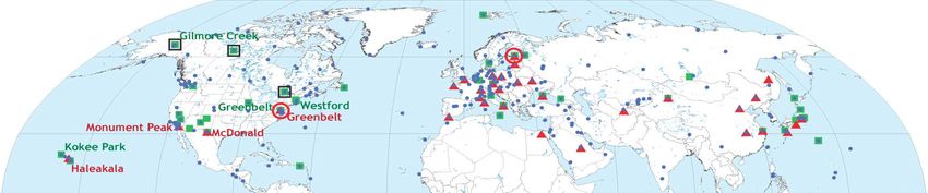
Gliederung

▪      Einführung
▪      GGOS als Beobachtungssystem
▪      GGOS als Organisation
▪      GGOS als Infrastruktur
▪      Zusammenfassung und Wertung

24.04.2013             FGS-Workshop 2013 in Bad Kötzting                2
Einführung
                                                                         Motivation

▪    Zunahme von Naturkatastrophen
             − Vorhersage und Warnung

    24.04.2013                      FGS-Workshop 2013 in Bad Kötzting                 3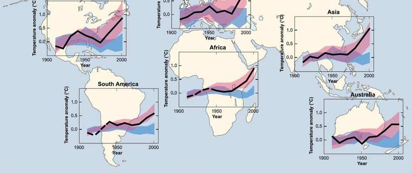
Einführung
                                                                         Motivation

▪    Zunahme von Naturkatastrophen
             − Vorhersage und Warnung

▪    Globaler Klimawandel

    24.04.2013                      FGS-Workshop 2013 in Bad Kötzting                 4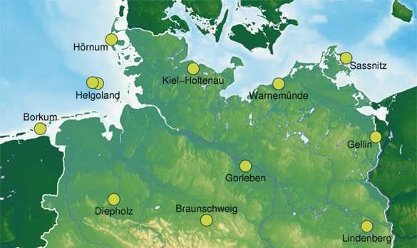
Einführung
                             Geodätischer Zugang

                                                 (Schuh et al., 2004)
24.04.2013   FGS-Workshop 2013 in Bad Kötzting                    5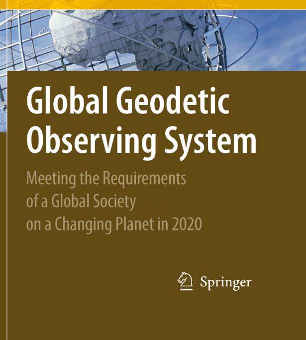
Einführung
                                          Entwicklung des GGOS
GGOS: Meeting the Requirements of a Global Society on a Changing
Planet in 2020. Eds. H.-P. Plag and M. Pearlman. Springer 2009. p. 332

                              GGOS-Buch
                              Inhalt: Zentrale Argumente für GGOS

                              ▪ Goals, achievements and tools of modern geodesy

                              ▪ Earth science requirements for geodesy

                              ▪ Maintaining a modern society (9 societal benefit
                                 areas)

                              ▪ Future geodetic reference frames

                              ▪ Future Global Geodetic Observing System (GGOS)

                              ▪ GGOS 2020

                                                                                   6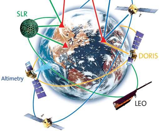
Einführung
                        IAG-Rahmenpapiere zu GGOS

IAG Bylaws 1(d)
  “The Global Geodetic Observing System works with the
  IAG components to provide the geodetic infrastructure
  necessary for monitoring the Earth system and global
  change research.”

The vision of GGOS is
  “Advancing our understanding of the dynamic Earth
  system by quantifying our planet’s changes in space
  and time.”

   24.04.2013           FGS-Workshop 2013 in Bad Kötzting   7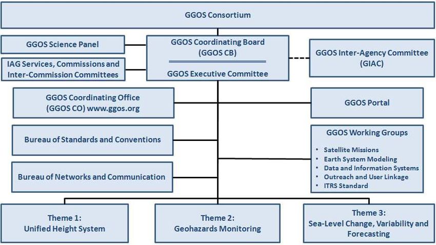
Einführung
                             IAG-Rahmenpapiere zu GGOS

Motivation (GGOS ToR)
“We live on a dynamic planet in constant motion that requires long-
term continuous quantification of its changes in a truly stable frame of
reference.”

The mission of GGOS is:
To provide the observations needed to monitor, map and understand
changes in the Earth’s shape, rotation and mass distribution.
To provide the global frame of reference that is the fundamental
backbone for measuring and consistently interpreting key global
change processes and for many other scientific and societal
applications.
To benefit science and society by providing the foundation upon which
advances in Earth and planetary system science and applications are
built.

  24.04.2013                 FGS-Workshop 2013 in Bad Kötzting             8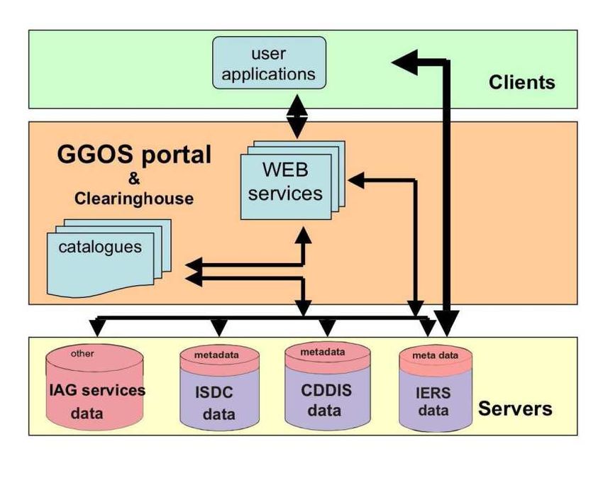
Einführung
                               IAG-Rahmenpapiere zu GGOS

The goals of GGOS are:

  1. To be the primary source for all global geodetic information and
  expertise serving society and Earth system science.
  2. To actively promote the sustainment, improvement and evolution of
  the global geodetic infrastructure needed to meet Earth science and
  societal requirements.
  3. To coordinate with the international geodetic services that are the
  main source of key parameters needed to realize a stable global
  frame of reference and to observe and study changes in the dynamic
  Earth system.
  4. To communicate and advocate the benefits of GGOS to user
  communities, policy makers, funding organizations, and society.

     24.04.2013                FGS-Workshop 2013 in Bad Kötzting           9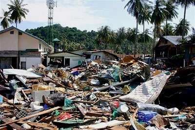
GGOS als Beobachtungssystem
                                                           Geometrie

                                                  ,
                     International Terrestrial Reference Frame (ITRF)

                             International Earth Rotation Service
                                            (IERS)

                      Quellenpositionen, präzise
                      Quellenpositionen,       , GPS
                                                 GPS--Orbits und Uhren
                                                                 Uhren,,
                         Erdrotationsparameter,, Stationskoordinaten
                         Erdrotationsparameter

Very Long Baseline         Satellite Laser             Global Navigation   Doppler Orbit Determination
                                                                              and Radiopositioning
  Interferometry              Ranging                  Satellite Systems      Integrated on Satellite
       (IVS)                   (ILRS)                         (IGS)                 (IDS)
GGOS als Beobachtungssystem
Physik
…
CHAMP GRACE GOCE GRACE Follow-on (from 2017)
… …
Topex/Pos. JASON-1 JASON-2 TerraSAR-X TanDEM-X
… …
CHAMP COSMIC MetOp CHAMP SWARM
… neue Missionskonzepte,
… Satellitenkonstellationen, Mikro-
satelliten inder Betrachtung
IceSat-1 Cryosat-2 IceSat-2 11GGOS als Beobachtungssystem
Technische Ziele
Genauigkeiten auf globaler Skala:
1 mm für die Position
0.1 mm/yr
im ITRF
Kontinuierliche Messungen (Zeitreihen von EOP,
Stationspositionen und Basislinien)
Messungen nahe Echtzeit
Höchste Zuverlässigkeit und Redundanz
Niedrige Konstruktions- und Betriebskosten für die
geodätischen Systeme
24.04.2013 FGS-Workshop 2013 in Bad Kötzting 12GGOS als Organisation
Einbettung in die IAG
International Union of Geodesy and Geophysics (IUGG)
65 Member Countries (Adhering Bodies), 8 Associations
International Association of Geodesy (IAG)
Council Executive Committee Bureau Office COB
Commission 1 Commission 2 Commission 3 Commission 4
Earth Rotation and Positioning and
Reference Frames Gravity Field Geodynamics Applications
Inter-Commission Committee on Theory (ICCT)
Services: IERS IGS IGFS BGI ICET BIPM IAS
ILRS IVS IDS ICGEM IGeS IDEMS PSMSL IBS
Global Geodetic Observing System (GGOS) 13GGOS als Organisation
Interne Organisation
24.04.2013 FGS-Workshop 2013 in Bad Kötzting 14GGOS als Infrastruktur
Definitionen
Infrastruktur
Alle langlebigen Grundeinrichtungen materieller und instutioneller
Art, die das Funktionieren einer arbeitsteiligen Volkswirtschaft
garantieren.
Geodateninfrastruktur
Komplexes Netzwerk zum Austausch von Geodaten, in dem
Geodaten-Produzenten, Dienstleister im Geo-Bereich sowie
Geodatennutzer über ein physisches Datennetz, in der Regel das
Internet, miteinander verknüpft sind.
Technische Infrastruktur für die Datenbereitstellung sowie
rechtliche, organisatorische und fachliche Regelungen.
Quelle: Wikipedia
24.04.2013 FGS-Workshop 2013 in Bad Kötzting 15GGOS als Infrastruktur
Organisatorische Anforderungen
▪ Beobachtungsinfrastruktur: GGOS Core Network
▪ Dateninfrastruktur: IAG Services, GGOS Portal
▪ Beitragende GIAC
− Raumfahrtagenturen
− Nationale geodätische Institute
− Nationale geodätisch-kartographische Behörden
▪ Übergeordnete Einbindung:
GGOS als IAG-Beitrag zu GEO / GEOSS !
24.04.2013 FGS-Workshop 2013 in Bad Kötzting 16GGOS als Infrastruktur
Beobachtungsarchitektur
Fünf Ebenen der GGOS-
Beobachtungsarchitektur
Ebene 1:
Bodenstationen, terrestrische Messungen
Ebene 2:
Low Earth Orbiter
Ebene 3:
Medium / Geostationary Earth Orbiter
Ebene 4:
Mond, Planeten
Ebene 5:
Quasare
Quelle: Plag et al. (2009)
24.04.2013 FGS-Workshop 2013 in Bad Kötzting 17GGOS als Infrastruktur
Derzeitiges terrestrisches Netz
Globales Netz geodätischer Stationen und Observatorien (derzeit)
Quelle: NASA
24.04.2013 FGS-Workshop 2013 in Bad Kötzting 18GGOS als Infrastruktur
Geplantes terrestrisches Netz
Globales Zielnetz (GGOS Core Sites)
GEO Sub-task DA-09-02c
▪ GGOS target network design GGOS Member States with Core site activities:
United States Germany China
• 30 globally distributed, multi-technique co- Korea Australia Russia
located ground stations New Zealand India Saudi Arabia
• 4 techniques/site South Africa Spain
24.04.2013 FGS-Workshop 2013 in Bad Kötzting 19GGOS als Infrastruktur
Dateninfrastruktur
GGOS Datenströme
• Einheitliche
Kommunikations- und
Dateninfrastruktur für alle
Raumverfahren
• Echtzeit-Datenaustausch
24.04.2013 FGS-Workshop 2013 in Bad Kötzting 20GGOS als Infrastruktur
Derzeitige Aktivitäten
Strategic Activities GGOS 2020 Project
(Policy, International Activities
Coordination, Advocacy) (Building GGOS)
Slides by Juan
Ceva and Ruth
NeilanGGOS als Infrastruktur
Planungen: System of Systems
▪ “A system of systems is a
supersystem comprised of System
1
elements that are themselves
complex, independent systems
that interact to achieve a System System
common goal” (1) n GGOS 2
▪ Systems (legacy systems, brand 2020
new systems, future systems) (SoS)
▪ Adaptability for dynamic
participation (1) System System
4 3
▪ Closed collaborative architecture
(2)
▪ Approach:
− Architecture-centric Interfaces between Systems and
− Model-centric GGOS 2020 SoS can be achieved
via International Services
− User-centric (1)
(1) Source: “System of Systems Engineering; System of Systems Engineering of GEOSS, M. Jamshidi, ed., Wiley, 2009
(2) Source: “The Art of Systems Architecting”, M. Maier & E. Rechtin, Taylor & Francis, 2009GGOS als Infrastruktur
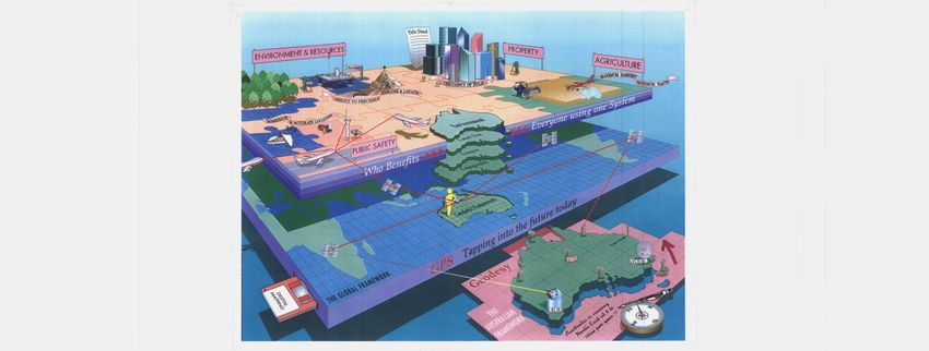
Übergeordnete Einbindung
Geoscience Australia
24.04.2013 FGS-Workshop 2013 in Bad Kötzting 23GGOS als Infrastruktur
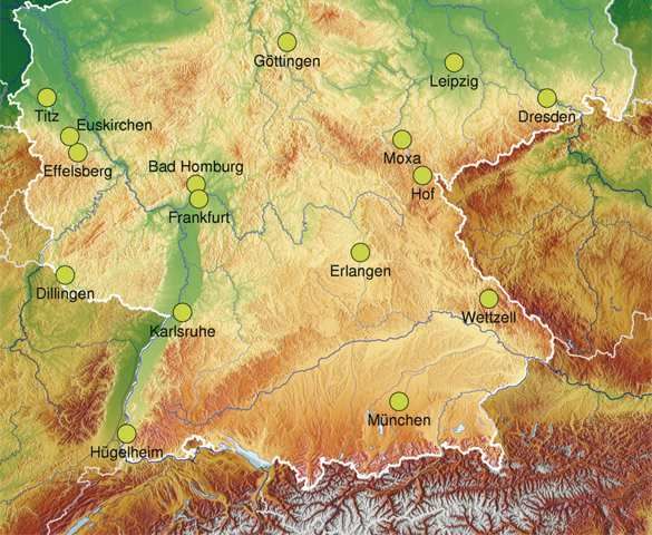
Nationale Bereitstellung
Das Integrierte Deutsche
Geodätische Referenznetz GREF
Ziele und Aufgaben:
▪ Realisierung und Laufendhaltung
eines einheitlichen dreidimensio-
nalen Raumbezugs in D
▪ Einbindung dieses Systems in
das Europäische und das
Internationale Terrestrische
Referenzsystem
▪ Unterstützung von Realtime-
Satellitenpositionierungsdiensten
▪ Überwachung zeitlicher
Veränderungen an den Stationen
▪ Bestimmung der Höhenbezugs-
fläche
24.04.2013 FGS-Workshop 2013 in Bad Kötzting 24Zusammenfassung und Wertung
▪ Bündelung und Koordination vorhandener
Infrastruktur
▪ Weiterentwicklung von Beobachtungstechnologien
und Beobachtungsnetzen
▪ Etablierung einer Dateninfrastruktur
▪ Infrastrukturen als unverzichtbare Basis für jegliche
Nutzung von Raumbezug und Geodaten
▪ Gesellschaftlicher Nutzen auf politischer Ebene von
besonderer Relevanz
24.04.2013 FGS-Workshop 2013 in Bad Kötzting 25Sie können auch lesen