MOUNTAIN BIKE CALA RAJADA - SA FONT DE SA CALA CANYAMEL - CALA MESQUIDA - WELCOME TO CAPDEPERA - MALLORCA PURE MOUNTAIN BIKE - Hotel Capricho ...

Die Seite wird erstellt Günter Gebhardt
 
WEITER LESEN
MOUNTAIN BIKE CALA RAJADA - SA FONT DE SA CALA CANYAMEL - CALA MESQUIDA - WELCOME TO CAPDEPERA - MALLORCA PURE MOUNTAIN BIKE - Hotel Capricho ...
C A L A R A JA DA - SA FO N T D E SA C A L A
          C A N YA M E L - C A L A M E S Q U I D A

               MOUNTAIN
                   BIKE

WELCOME TO CAPDEPERA - MALLORCA PURE MOUNTAIN BIKE
MOUNTAIN BIKE CALA RAJADA - SA FONT DE SA CALA CANYAMEL - CALA MESQUIDA - WELCOME TO CAPDEPERA - MALLORCA PURE MOUNTAIN BIKE - Hotel Capricho ...
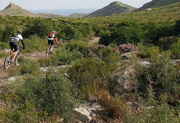
DISCOVER THE MTB ROUTES AROUND CALA RAJADA,
CANYAMEL, FONT DE SA CALA AND CALA MESQUIDA
Paths and tracks that wind through extensive Mediterranean woodland and end
at wonderful beaches and unspoilt coves, ascents up the side of imposingly high
mountains and endless descents into nature reserves, entertaining narrow uneven
tracks beside the deep turquoise sea, rural lanes and inland towns rich in history …
18 routes for mountain bike in a fairy-tale landscape.
MOUNTAIN BIKE CALA RAJADA - SA FONT DE SA CALA CANYAMEL - CALA MESQUIDA - WELCOME TO CAPDEPERA - MALLORCA PURE MOUNTAIN BIKE - Hotel Capricho ...
EXPLORE, GET FIT, ENJOY!
     ERKUNDE, TRAINIERE UND GENIESSE!

ENTDECKE DIE ROUTEN FÜR MTB IN CALA RAJADA,
CANYAMEL, FONT DE SA CALA UND CALA MESQUIDA
Wege und Pfade, die durch ausgedehnte Waldgebiete am Mittelmeer verlaufen und an
wunderschönen Stränden und unbebauten Buchten enden, auf beeindruckende Berge
hinaufsteigen und über endlose Abfahrten in Naturschutzgebiete hinunterführen;
aufregende schmale Schotterpisten am Rande des tiefblauen Meeres, ländliche
Nebenstrassen und geschichtsträchtige Städtchen im Binnenland...
18 Routen für Mountain Bike in einer märchenhaften Landschaft.
MOUNTAIN BIKE CALA RAJADA - SA FONT DE SA CALA CANYAMEL - CALA MESQUIDA - WELCOME TO CAPDEPERA - MALLORCA PURE MOUNTAIN BIKE - Hotel Capricho ...
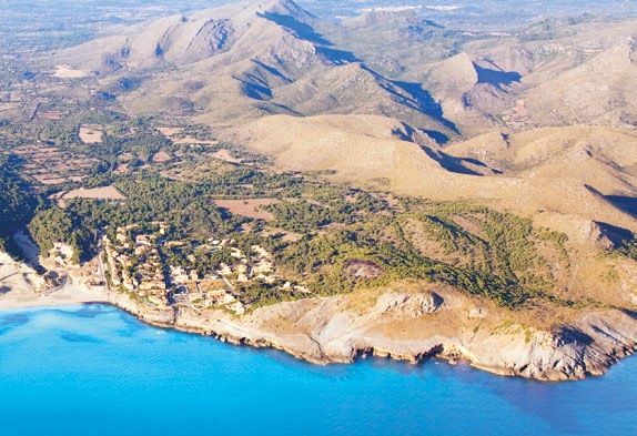
1   Font de sa Cala "per a tots"                            10      Coll des Racó
2   Camí Reial                                              11      Sa Duaia i Sa Jordana
3   Punta de n'Amer                                         12      Ses Costellades des de Cala Rajada
4   Via Verda                                               13      Cala Rajada / Far / Puig de s'Àguila
5   Antenes Son Servera                                     14      Cova Negra                       WEB

6   Cala Rajada                                             15      Sa Duaia / Es Verger
7   Canyamel / Sa Duaia de Baix                             16      Vall des Verger
8   Coll d'Artà                                             17      Puig de Can Cardaix
9   Na Llòbrega                                             18      S’Esquena Llarga
                                                                                               ORUXMAPS
    Historical and cultural           Circular routes     Picturesque      Climbing tracks
    monuments                         Rundwege            countryside      Bergstrecken
    Kulturhistorisches Erbgut                             Malerische
                                                          Landschaft
    Rest zone                   Flora and fauna          Beaches           Tunnel
    Ruhezone                    Flora und Fauna          Strände           Tunnel

                                         DIFFICULTY / SCHWIERIGKEITSGRAD                     Free Android app

     Very easy / Ganz leicht         Easy /Leicht       Medium / Mittel      High / Hoch     Very hard / Sehr hoch
MOUNTAIN BIKE CALA RAJADA - SA FONT DE SA CALA CANYAMEL - CALA MESQUIDA - WELCOME TO CAPDEPERA - MALLORCA PURE MOUNTAIN BIKE - Hotel Capricho ...
Font de sa Cala “per a tots”
                                                                             1

    DIFFICULTY        DISTANCE    DURATION   MIN. ALTITUDE   MAX. ALTITUDE
SCHWIERIGKEITSGRAD   ENTFERNUNG    DAUER       MIN. HÖHE      MAX. HÖHE

                     20,51 km     1:21 h.       4m              84 m
MOUNTAIN BIKE CALA RAJADA - SA FONT DE SA CALA CANYAMEL - CALA MESQUIDA - WELCOME TO CAPDEPERA - MALLORCA PURE MOUNTAIN BIKE - Hotel Capricho ...
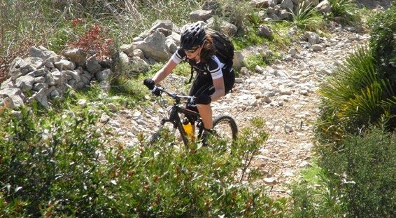
Font de Sa Cala “for everyone”                                    Font de Sa Cala “für alle”
Beaches, mountains, promenades, coastal and inland                 Strände, Berge, Promenaden, Strassen an der Küste
roads succeed each other in an easy but varied                     und übers Land wechseln sich auf dieser leichten
tour. It is a fun excursion, ideal for an outing with              aber vielseitigen Route ab. Es ist ein lustiger Ausflug,
all the family, that introduces us to the beauty of                ideal für die ganze Familie, der uns die Schönheit
the location. We will pay a visit to Sa Pedruscada,                der Gegend vor Augen führt. Wir besuchen Sa
Es Carregador, the delightful beach at Font de sa                  Pedruscada, Es Carregador, den herrlichenFont de sa  Cala Pe
                                                                                                                     Strand
Cala and the remains of a C I C L I S M O      P OR E N R IQU E D E L R IO GU E R R E R O von Font de sa Cala und sehen
prehistoric settlement called                                                             die 20.51
                                                                                              Restekmder prähistorischen 1:21:
“Es Claper des Gegants”. On                                                               Siedlungsstätte
                                                                                              Distancia      “Es Claper des Tiempo
the way we will skirt round                                                               Gegants”. Wir umrunden die
the town of Capdepera and                                                                 Stadt Capdepera und kommen
finish up again in Cala Rajada.                                                           zum Schluss in Cala Rajada Altura
Be careful, the coastal                                                                   wieder an. Aufpassen, an der 152 m
promenade is often quite                                                                  Küstenpromenade sind oft viele Gananc
busy with lots of pedestrians                                                             Fussgänger unterwegs, so dass 151 m
and you may find you have                                                                 wir vielleicht zwischendurch
                                                                                                                            Altura p
to dismount and push your                                                                 mal absteigen und das Fahrrad
                                                                                                                            4m
bike for a while.                                                                         schieben
                                                                                              1:19:18   müssen.
                                                                                              Tiempo en movimiento            Altura m

                                                                                              1:21:34                         84 m
                                                                                              Tiempo transcurrido             Altura m

                                   Altura

                                     200
MOUNTAIN BIKE CALA RAJADA - SA FONT DE SA CALA CANYAMEL - CALA MESQUIDA - WELCOME TO CAPDEPERA - MALLORCA PURE MOUNTAIN BIKE - Hotel Capricho ...
Camí Reial
                                                                             2

                 DIFFICULTY        DISTANCE    DURATION   MIN. ALTITUDE   MAX. ALTITUDE
             SCHWIERIGKEITSGRAD   ENTFERNUNG    DAUER       MIN. HÖHE      MAX. HÖHE

                                  30,22 km     1:51 h.       3m              96 m
MOUNTAIN BIKE CALA RAJADA - SA FONT DE SA CALA CANYAMEL - CALA MESQUIDA - WELCOME TO CAPDEPERA - MALLORCA PURE MOUNTAIN BIKE - Hotel Capricho ...
Camí Reial – The King’s Road                                Camí Reial – Der Königsweg                                     Cami R
From Cala Agulla beach we ride up the track to “Es       Vom Strand der Cala Agulla aus steigen wir nach oben M
Coll de Marina” and on the way down the other side       über “Es Coll de Marina” und radeln auf der anderen
we can see Cala Mesquida. We cross behind the            Seite hinunter zur Cala Mesquida, die wir hinter dem
beach on a long wooden bridge and set off again on       Strand an einer langen Holzbrücke überqueren;
                            CiclismoLater we reach Son
hilly tracks with ups and downs.                         danach
                                                              P O R Ekommt
                                                                     N R I Q U E D Ewieder
                                                                                    L R I O G U E eine
                                                                                                  R R E R O bergige Strecke mit

Barbassa and from there the Camí Reial, the ancient      abwechselnd auf- und absteigenden Wegen. An Son
King’s Road connecting the old                                                     Barbassa vorbei erreichen       30.22     wirkmden 1
                                                                                                                   Distancia
Mallorcan rural estates between                                                    Camí Reial, den Königsweg,                der die Tie
Capdepera and Artá. We                                                             alten mallorquinischen Gutshöfe
continue along by-roads through                                                    von Capdepera und Artá
                                                                                                                   16.3      km/h
                                                                                                                         verbindet. Ga
                                                                                                                                         3
                                                                                                                   Velocidad media
the outlying rural area. Towards                                                   Über Nebenstrassen umgehen wir
the end of this route we pass a                                                    die Stadt. Gegen Ende der Route an                    Al
golf course which gives us access                                                  einem Golfplatz vorbei kommen wir                     34
to “Es Claper des Gegants”, a                                                      zu “Es Claper des Gegants”, einer                     Ga
prehistoric settlement site. A                                                     prähistorischen Siedlungsstätte. Ein
                                                                                                                                         34
track takes us from there down to                                                  Weg führt uns zum touristischen                       Alt
the tourist resort Font de sa Cala                                                 Vorort von Font de sa Cala mit
with its wonderful little bay. The                                                 einer wunderschönen 1:41:17        Naturbucht.        3
return road to Cala Rajada runs                                                    Die letzte Etappe nachTiempo       CalaenRajada
                                                                                                                              movimiento Al

along by the sea.                                                                  zurück verläuft am Meer entlang.                      9
                                                                                                                1:50:57
                                                                                                                Tiempo transcurrido      Al

                             Altura
MOUNTAIN BIKE CALA RAJADA - SA FONT DE SA CALA CANYAMEL - CALA MESQUIDA - WELCOME TO CAPDEPERA - MALLORCA PURE MOUNTAIN BIKE - Hotel Capricho ...
Punta de n’Amer
                                                                          3

              DIFFICULTY        DISTANCE    DURATION   MIN. ALTITUDE   MAX. ALTITUDE
          SCHWIERIGKEITSGRAD   ENTFERNUNG    DAUER       MIN. HÖHE      MAX. HÖHE

                               52,48 km     2:52 h.       0m             120 m
MOUNTAIN BIKE CALA RAJADA - SA FONT DE SA CALA CANYAMEL - CALA MESQUIDA - WELCOME TO CAPDEPERA - MALLORCA PURE MOUNTAIN BIKE - Hotel Capricho ...
Punta de n’Amer                                                      Punta de n’Amer
      We suggest a lengthy but technically not difficult                    Wir schlagen euch nun eine längere aber technisch
      excursion that takes us to the old defence tower “Es                  nicht sehr schwere Strecke vor, deren Ziel der alte
      Castell” in the landscape conservation area of Punta                  Wehrturm “Es Castell” im Landschaftsschutzgebiet
      de n’Amer, which lies between the tourist resorts of                  Punta de n’Amer zwischen den Tourismuszentren vonPunt
      Cala Millor and Sa Coma. FromC ICala
                                        C L I S MRajada
                                                  O     we make           P Cala
                                                                            OR E NMillor
                                                                                  R IQU E und
                                                                                          D E L RSa  Coma
                                                                                                  IO GU E R R Ebildet.
                                                                                                               RO      Von Cala Rajada aus
      an obligatory little detour to the Castle of Capdepera                machen wir zwangsläufig einen kleinen              Abstecher zur
                                                                                                                        52.48 km
      (impressive medieval fortifications)                                                  Burg von Capdepera (beeindruckende
      and then follow roads and lanes to the                                                Burg aus dem Mittelalter)   Distancia
                                                                                                                                  und fahren
      town of Son Servera, where a short                                                    dann auf Strassen und Nebenstrecken
      stop at the so-called New Church is                                                   nach Son Servera, wo es sich lohnt, kurz
      highly recommended (the church is                                                     in der sog. Neuen Kirche Rast zu machen
      open to the sky). We ascend the hill                                                  (die Kirche steht zum Himmel offen).
      called Puig de sa Bassa, where we are                                                 Wir steigen am Hügel Puig de sa Bassa
      rewarded with delightful views over                                                   hoch, von wo aus es eine wunderschöne
      the bay. The descent along tracks and                                                 Aussicht über die Bucht gibt. Über
      roads leads to the vicinity of Sa Coma,                                               Wege und Strassen erreichen wir die
      where a stretch of wide and level track                                               Umgebung von Sa Coma, wo ein breiter,
      takes us to Punta de n’Amer. Part of                                                  ebener Weg nach Punta de n’Amer führt.
      the way home is along the pretty                                                      Auf dem Rückweg folgen wir zum Teil
      coastal promenades of Cala Millor, Sa                                                 der Küste an den Promenaden von Cala
200
      Coma and Port Vell.                                                                   Millor, Sa Coma und Port Vell.
100
                                                                                                                   3:56:52
                                                                                                                   Tiempo en movimiento

  0
                           10.00       15.00        20.00         25.00           30.00        35.00       40.00            45.00         50.00
Via Verda
                                                                             4

    DIFFICULTY        DISTANCE    DURATION   MIN. ALTITUDE   MAX. ALTITUDE
SCHWIERIGKEITSGRAD   ENTFERNUNG    DAUER       MIN. HÖHE      MAX. HÖHE

                     79,57 Km     3:44h.        6m             128 m
The Green Way                                                     Der grüne Weg
      The old railway that used to connect the towns in                Die alte Eisenbahn verband einst die Städte im
      the interior of Mallorca now offers a level track with           östlichen Herzen von Mallorca und ihre Trasse bietet
      a good surface of gravel and compacted earth. It is              eine ebene Strecke mit fester Fahrbahn aus Kies und
      an easy, safe route for cyclists, bordered by fences             Erde. Der einfache und sichere Radweg, eingezäunt
      and trees, and joins the towns of Artá, Son Servera,             und mit Bäumen am Wegesrand, verbindet Artá, Son
      Son Carrió, San Lorenzo andC Manacor.  Along the way             Servera, Son Carrió, San Lorenzo und Manacor. Die
                                                                                                                                Via   Ver
                                   IC L ISMO
      the scenery alternates between agricultural fields               Landschaft wechselt zwischen landwirtschaftlich
                                                       P OR E N R IQU E D E L R IO GU E R R E R O

      and Mediterranean woodland,                                                                 bewirteten
                                                                                                        79.57 km Flächen        und   3:4
      and the track passes through                                                                den typischen Wäldern des            Tiem
                                                                                                        Distancia
      tunnels and stations. There are                                                             Mittelmeers; der Weg führt durch
      7 rest areas with tables and                                                                Tunneln und alte Bahnhöfe. Es
      benches. From Cala Rajada we                                                                gibt 7 Rastplätze mit Tischen
      cycle there along the by-roads                                                              und Bänken. Von Cala Rajada         Altur

      via Son Jaumell and Na Maians,                                                              fahren wir an Nebenstrassen
      from Canyamel the access to                                                                 über Son Jaumell und Na             498
      the track is by following route                                                             Maians, von Canyamel finden         Gana
      7 which joins up with the Via                                                               wir den Anschluss über die
                                                                                                                                      501
      Verde. It is a relaxing route                                                               Route 7 zur Via Verde. Der Weg
      through attractive countryside                                                              ist bequem und landschaftlich       Altura

      that you are sure to like. You                                                              schön, er wird euch begeistern.     6m
      set your own limits but think                                                               Deine 3:44:11
                                                                                                         Grenzen setzt du selbst,
                                                                                                                                      Altura
200
      of the way back and save your                                                               aber denke      bitte auch an den
                                                                                                        Tiempo en movimiento

      strength.                                                                                         3:53:56
                                                                                                  Rückweg    und spare deine Kräfte   128
                                                                                                  auf. Tiempo transcurrido            Altur
 00

               8:20      16:40      25:00       33:20      41:40      50:00       58:20    1:06:4
                                                                                               0     1:15:0
                                                                                                         0     1:23:2
                                                                                                                   0      1:31:40
  0
Antenes Son Servera
                                                                         5

              DIFFICULTY        DISTANCE    DURATION   MIN. ALTITUDE   MAX. ALTITUDE
          SCHWIERIGKEITSGRAD   ENTFERNUNG    DAUER       MIN. HÖHE      MAX. HÖHE

                               46,98 Km     2:47 h        5m             164 m
Antennas of Son Servera                                               Antennen von Son Servera
                                                                                                                  Antenas Son Serv
    The inland route almost lets us forget that we are on           Eine Inlandroute, die uns fast vergessen lässt, dass
    an island, until we reach the summit of the mountain            wir uns auf einer Insel befinden, bis wir den Gifel des
    Puig de Son Corp and can enjoy the spectacular view             Berges Puig de Son Corp erreichen, der uns einen
    out over the bay.          C IC L ISMO          P OR E N R IQU E D E L R IO GU E R R E R O wunderschönen Ausblick über die
    On rural by-ways and stretches                                                             Bucht bietet.
                                                                                                     46.98 km
    of the old railway bed, the    Via   0
                               Me gusta                                                        Über ländliche Nebenstrassen und2:47:45
                                                                                                     Distancia
    Verde, we wander between the                                                               Teilstrecken der alten BahntrasseTiempo
    towns in the extreme eastern                                                               Via Verde wandern wir zwischen
    part of Mallorca: Capdepera,                                                               den Städten im äussersten OstenAltura
    Artá and Son Servera. A steep                                                              von Mallorca: Capdepera, Artá
    and narrow path leads us up                                                                und Son Servera. Ein enger,476 m
    to the top of Puig de Son                                                                  steiler Pfad führt uns hinauf zumGanancia
    Corp. From there we take the                                                               Puig de Son Corp. Anschliessend
    technically most challenging                                                               kommt die Abfahrt, die technisch477 m
    and enjoyable descent on                                                                   schwierigste und lustigste StreckeAltura perd
    this route. It is quite a steep                                                            auf dieser Route. Es handelt5 m
    track, a bit difficult in places                                                           sich 2:40:19
                                                                                                     um einen relativ steilen und
                                                                                                                                    Altura mín
    and concentration is required,                                                             nichtTiempo
                                                                                                        ganz       einfachen Abstieg,
                                                                                                             en movimiento

    especially where the path                                                                  wo man an manchen Stellen sehr164 m
                                                                                                     2:47:44
    becomes very narrow.                                                                       aufpassen       muss, besonders wo es
                                                                                                                                    Altura máx
200
                                                                                               ganz   eng transcurrido
                                                                                                     Tiempo  wird.

00

                                    Altura
              16:40         33:20            50:00     1:06:40        1:23:20       1:40:00       1:56:40       2:13:20       2:30:00
 0
                                      200
Cala Rajada
                                                                             6

    DIFFICULTY        DISTANCE    DURATION   MIN. ALTITUDE   MAX. ALTITUDE
SCHWIERIGKEITSGRAD   ENTFERNUNG    DAUER       MIN. HÖHE      MAX. HÖHE

                     14,49 Km     1:13 h.       6m             101 m
Cala Rajada                                                                  Cala Rajada
      A short but wonderful route with tracks and trails                              Eine kurze aber herrliche Route, die über Auf- und
      leading up and down that introduces us to the area                              Abstiege, Wege und Pfade dieCala             Ratjada
                                                                                                                              Gegend      um CalaB
      around Cala Rajada from its most natural and scenic                             Rajada von ihrer landschaftlich schönsten Seite zeigt:
      side: the prettiest beaches, secluded little bays and                           die hübschesten Strände, einsame kleine Buchten und
      the extensive pine forest  that
                           CICLISM O  surrounds
                                            P O R Ethem.
                                              ▼     N R I Q U EWe
                                                               D E L set
                                                                     R I O G U E R R Edie
                                                                                       R O ausgedehnten Pinienwälder, die sie umgeben. Wir
      off and climb a little way up “Telegraph Mountain”,                             legen los und steigen ein Stück am “Telegraphenberg”
      then take the track through pines                                                                   hinauf, fahren
                                                                                                                      14.49      kmdurch 1:13:21
                                                                                                                            weiter          Pinien
      and dwarf palms called “Es Coll                                                                     und Fächerpalmen
                                                                                                                      Distancia
                                                                                                                                    am Weg       “Es
                                                                                                                                            Tiempo
      de Marina” that ends at the wide                                                                    Coll de Marina”, der an den Dünen
      expanse of dunes behind the                                                                         hinter dem  11.8Strandkm/h von260    Cala m
      beach at Cala Mesquida. On the                                                                      Mesquida Velocidad
                                                                                                                      endet.mediaAuf demGanancia
                                                                                                                                               Wegde altura
      way down we pass along a river                                                                      nach unten durchqueren wir eine
      bed, from which we then climb up                                                                    Strecke im Flussbett, ausAltura      dem
      again to ride around the shoulder                                                                   wir wieder nach oben und         260 um m
      of the mountain called “Es Puig                                                                     den Berg “Es Puig de s’Àguila”   Ganancia de altura

      de s’Àguila”. On the way we pass                                                                    fahren. Unterwegs stossen        261 m  wir
      several of the traditional old lime                                                                 auf alte Kalköfen, “Forns deAltura Calç”,
                                                                                                                                                  perdida

      kilns, “Forns de Calç”, typically                                                                   eine typische
                                                                                                                     1:09:45Erscheinung 6inmden
      found in the woods on Mallorca.                                                                     Wäldern von     Mallorca.
                                                                                                                     Tiempo en movimiento  Altura mínima

                                                                                                                        1:13:21               101 m
                                                                                                                        Tiempo transcurrido   Altura máxima
100

  0                              Altura
                                   100
                     8:20             16:40            25:00            33:20            41:40                              58:20
Canyamel / Sa Duaia de Baix
                                                                             7

    DIFFICULTY        DISTANCE    DURATION   MIN. ALTITUDE   MAX. ALTITUDE
SCHWIERIGKEITSGRAD   ENTFERNUNG    DAUER       MIN. HÖHE      MAX. HÖHE

                     32,84 Km     2:14 h.       5m             237 m
Canyamel / Sa Duaia de Baix                                             Canyamel / Sa Duaia de Baix
This route provides a combination of tracks and                      Die Route beitet Wege und Strassen, sportliche
roads, sporting activity and attractive natural scenery              Tätigkeit und schöne Umgebung und beginnt am
and starts at the beach in Canyamel. The tour takes                  Strand von Canyamel. Sie führt uns zunächst nach
us first to Artà, passing by the old 13th century                    Artà, vorbei am Wehrturm von Canyamel aus dem 13.
defence tower of Canyamel and the sculpture by                       Jahrhundert und an der Skulptur von                Canyamel­Duaia­d
                                                                                                                             Sarasate “Die
                                C IC L ISMO       P OR E N R IQU E D E L R IO GU E R R E R O
Sarasate called “The guardians of Canyamel”, and                     Wächter von Canyamel” und dann über die Via Verde.
then along the Via Verde. An uphill                                                                    32.84 km
                                                                                             Eine ansteigende               Asphaltstrasse 2:14:1
stretch on asphalt roads takes us                                                            bringt uns      auf den Berg von Sa Tiempo
                                                                                                       Distancia

to the mountain of Sa Duaia, from                                                            Duaia, von wo aus es auf Erd- und
where an exciting earth and gravel                                                           Schotterpfaden lustig bergab geht
track heads downhill (with lots of                                                           (mit vielen Erdbeerbäumen) um Altura
strawberry trees) before climbing                                                            dann wieder an einem von der
again through an area reforested by                                                          Stromgesellschaft              aufgeforsteten 336 m
the electricity company. There are                                                           Weg nach oben zu fahren. Es gibt Gananci
narrow stretches with loose stones                                                           auch Engpässe mit losen Steinen, die 364 m
that are a challenge to our balance                                                          unser Gleichgewicht auf die Probe Altura pe
and will delight all mountain bikers.                                                        stellen und eine wahre Freude für 5 m
After a break to enjoy the wonderful                                                         Biker sind.     Nach dem Genuss der
                                                                                                       2:08:57
views, the track leads on downhill.                                                          herrlichenTiempo             geht die Route Altura m
                                                                                                              en movimiento
                                                                                                           Aussicht
                                                                                             abwärts weiter.
                                                                                                       2:13:42                             237 m
                                                                                                       Tiempo transcurrido                Altura má

                                      Altura

                                        400
Coll d’Artà
                                                                             8

    DIFFICULTY        DISTANCE    DURATION   MIN. ALTITUDE   MAX. ALTITUDE
SCHWIERIGKEITSGRAD   ENTFERNUNG    DAUER       MIN. HÖHE      MAX. HÖHE

                     54,87 Km     3:27 h.       3m             222 m
Coll d’Artà                                                         Coll d’Artà
This varied route alternates between fields, mountains             Diese abwechslungsreiche Route führt uns durch
and the beach and its greatest challenge lies in the               Felder, Berge und an der Küste und die grösste
distance to cover and a few stony tracks. We depart                Herausforderung wird ihre Länge und einige steinige
along by the sea on theC I C pretty
                             L I S M O track Sendero de sesP OR    Wege
                                                                  EN R IQU E sein.
                                                                              D E L RÜber
                                                                                     IO GU Eden
                                                                                             R R E hübschen
                                                                                                   RO        Weg Sendero de
Pites. From the beach in Font de Sa Cala we head                   ses Pites fahren wir am Meer entlang. Vom Strand in
towards Canyamel, where we cross a bridge over the                 Font de Sa Cala führt uns ein Weg      54.87    km Canyamel,
                                                                                                                nach
river bed. This marshy biotope                                                            wo wir am Strand      die
                                                                                                          Distancia
                                                                                                                     Brücke über
provides a natural habitat all                                                            den Flussbett überqueren. Hier
year round for a great number                                                             befindet sich ein Feuchtbiotop,
of wild birds. We cycle on roads                                                          der eine ganzjährige Zufluchtstätte
to reach the Via Verde, the                                                               für zahlreiche Vogelarten bietet.
old railway line, where we ride                                                           Über Strassen gelangen wir zur
towards Coll d’Artà. On earthen                                                           alten Bahntrasse, der Vía Verde,
and mountain tracks we pass by                                                            der uns zum Coll d’Artà bringt. Auf
Serral d’en Rulo and Bellpuig,                                                            unbepflasterten Wegen durchs
then take an asphalt road                                                                 Land und an den Hängen kommen
downhill to Artà. From there                                                              wir nach Serral d’en Rulo und
we once again pick up the Via                                                             Bellpuig, von wo eine absteigende
Verde and finally arrive back in                                                          Teerstrasse uns nach Artà bringt.
Cala Rajada.                                                                                              2:51:00
                                                                                          Nach einer weiteren    Strecke auf der
                                                                                          Vía Verde kommenTiempo wir
                                                                                                                  en movimiento
                                                                                                                      schliesslich
                                                                                          zurück nach Cala Rajada.
                                                                                                          3:27:55
                                                                                                          Tiempo transcurrido
Na Llòbrega
                                                                             9

    DIFFICULTY        DISTANCE    DURATION   MIN. ALTITUDE   MAX. ALTITUDE
SCHWIERIGKEITSGRAD   ENTFERNUNG    DAUER       MIN. HÖHE      MAX. HÖHE

                     17,01 Km     1:35 h.       8m              96 m
Na Llòbrega                                                      Na Llòbrega
“Na Llòbrega” is a solitary and unspoilt bay                    “Na Llòbrega” ist eine schwer zugängliche,
frequented by nudists that has given its name to this           naturbelassene FKK-Bucht, die diesem natürlichen
natural biker park.  Starting from the beach
                 Ciclismo                      of Cala
                                          POR ENRIQUE    DEL
                                                                Biker-Park ihren Namen verleiht. Wir fahren vom
                                                               RIO GUERRERO
Agulla, we pass by the little nudist bay of Cala Moltó          Strand der Cala Agulla an der kleinen FKK-Bucht
with its crystal-clear water and take a track to the                                                        17.01
                                                                der Cala Moltó mit ihrem kristallklaren Wasser   vorbeikm
right off the path up to “Coll                                                   und nehmen einen Weg, der       rechts
                                                                                                            Distancia
de Marina”. We climb part                                                        vom Aufstieg “Coll de Marina”
of the way up Telegraph Hill,                                                    abbiegt. Dort steigen wir einen
quite steep in places, where                                                     Stück auf dem etwas steileren Weg
between pine trees and dwarf                                                     zum Telegrafenberg hoch, wo wir
palms we may come upon an                                                        zwischen Pinien und Fächerpalmen
ancient lime kiln (“forn de                                                      einige alte Kalköfen (“forn de calç”)
calç”). Cycling down along                                                       entdecken können. Auf dem Weg
stony mountain tracks we                                                         nach unten über Schotter- und
discover an area of great                                                        Bergstrecken fahren wir durch
natural beauty and pass by                                                       eine     schöne       naturbelassene
an old quarry where in earlier                                                   Landschaft und kommen auch an
times the sandstone “marés”                                                                                 1:08:15
                                                                                 einem alten Steinbruch vorbei,       wo
blocks used on the island as                                                     früher die für BauzweckeTiempoauf ender
                                                                                                                       movimien
building material were cut.                                                      Insel benötigten „Marés“-Steine
                                                                                 geschnitten wurden.        1:35:34
                                                                                                              Tiempo transcurrido
Coll des Racó
                                                               10

              DIFFICULTY        DISTANCE    DURATION   MIN. ALTITUDE   MAX. ALTITUDE
          SCHWIERIGKEITSGRAD   ENTFERNUNG    DAUER       MIN. HÖHE      MAX. HÖHE

                               36,15 Km     2:26 h.       6m             237 m
Coll des Racó                                                               Coll des Racó
A fabulous route, this is pure joy for every biker. We           Eine grossartige Route, der Traum eines jeden Bikers.
meander through the woods with plenty of side                    Wir wenden unseren Weg durch die Wälder, machen
trips to beaches and secluded little coves with clear            Abstecher zum Strand und zu verborgenen                        Restaurante
                                                                                                                                      Buchten
turquoise water, along tracks surrounded by pine                 mit klarem türkisfarbenem Wasser an Schotterwegen
trees, dwarf palms and yellow gorse. In springtime               zwischen Pinien, Fächerpalmen und gelbem Ginster.
this route will enliven all      your senses. The mostP O R E N RIm
                            Ciclismo                              I Q U E Frühling
                                                                          D E L R I O G U E Reine
                                                                                              R E R O unglaubliche Sinnesfreude. Die
impressive section is along the path “Camí des Racó”,            beeindruckendste Strecke ist der Weg “Camí des
which joins up with the track to                                                                  Racó”, der sich mit36.15demkm    Weg nach2:26:56
Cala Mitjana and takes us up to                                                                   Cala Mitjana verbindet
                                                                                                                     Distancia und uns Tiempo
                                                                                                                                           zu
a property dating from the 15th                                                                   einem alten Haus aus dem 15. Jh
century (Restaurant), located on                                                                  führt (Restaurant), der auf einem m      521
top of a hill with views out over the                                                             Gipfel steht mit Ausblick über das       Ganancia de a

nature reserve Parc de Llevant. At                                                                Naturschutzgebiet Parc de Llevant.
                                                                                                                                           Altura
the top we pass the gates that give                                                               Am Ende des Aufstiegs geben uns
access to the asphalt road leading                                                                die Tore die Asphaltstrasse nach         521 m
down to Artá. We cycle a little                                                                   Artá frei. Dort fahren wir ein kurzes    Ganancia de a
way along the “Via Verde”, the old                                                                Stück auf der alten Bahntrasse, der
railway line, before detouring to                                                                 “Via Verde”, um dann in Richtung m      524
the road to Canyamel. We border                                                                   Canyamel abzubiegen. Am Golfplatz       Altura perdida

the golf course to descend to Cala                                                                vorbei kommen1:54:59   wir nach Cala    6m
Provençals and Font de Sa Cala on                                                                 Provençals und FontTiempode    Sa Cala auf
                                                                                                                            en movimiento
                                                                                                                                          Altura mínima
our way back to Cala Rajada. We                                                                   dem Heimweg nach
                                                                                                        1 miles 1 km
                                                                                                                           Cala Rajada. Es
                                                                                                                     2:26:56
promise you will love this route.                                                                 wird euch garantiert     gefallen.      237 m
                                                                                                                     Tiempo transcurrido
                                                                                                                                            Altura máxima

                                   Altura
Sa Duaia i Sa Jordana
                                                                       11

              DIFFICULTY        DISTANCE    DURATION   MIN. ALTITUDE   MAX. ALTITUDE
          SCHWIERIGKEITSGRAD   ENTFERNUNG    DAUER       MIN. HÖHE      MAX. HÖHE

                               46,23 Km     3:09 h.       9m             237 m
Sa Duaia and Sa Jordana                                   Sa Duaia und Sa Jordana
This very beautiful route with some difficult sections   Diese sehr schöne Route ist nicht ganz einfach. Sie
alternates Ciclismo
             between descents and steep ascents          bietet abwechselnd
                                                                        P O R auf-
                                                                              E N R und
                                                                                    I Q U Eabsteigende
                                                                                             D E L R I O GStrecken,
                                                                                                           UERRERO
with some uneven tracks and deep sand, and takes         unebene Wege und Tiefsand und sie führt uns in
us to the Nature Park Península de Llevant. Starting     den Naturpark Península de Llevant. Vom Wald
from the woods by Cala Agulla we head first to the       hinter der Cala Agulla erreichen wir den Strand von
beach of Cala Mesquida which                                              Cala Mesquida, dahinter liegt die
is known for the most extensive                                           weitläufigste Dünenlandschaft der
sand dunes in the Balearic Islands.                                       Balearen. In Richtung Cala Torta
Heading for Cala Torta a stretch of                                       kommen wir über Asphalt zum
asphalt takes us up to the mythical                                       sagenhaft gelegenen “Restaurant”.
“Restaurant”. We go downhill                                              Es geht bergab bevor wir den Weg
then up again on the lane to Cala                                         nach Cala Mitjana wieder nach oben
Mitjana. Open gates let us in to                                          nehmen. Durch ein Tor öffnet sich
descend on the “Camí del Racó”,                                           die Talfahrt am bezaubernden Weg
a magical track bordered by                                               “Camí del Racó” durch Steineichen
Mediterranean oak trees, to Artà.                                         bis Artà. Über alte Strassen
We cycle along old roads and past                                         und Fincas mit tausendjährigen
properties with thousand-year-old                                         Olivenbäumen kommen wir zur Via
olive trees to the old railway track,                                     Verde genannten alten Bahntrasse.
the Via Verde. Past a golf course                                         An einem Golfplatz vorbei
the by-roads take us back to Cala                                         erreichen wir über Nebenstrassen
Rajada, Canyamel, Font de sa Cala                                         Cala Rajada, Canyamel, Font de sa
or Cala Mesquida.                                                         Cala oder Cala Mesquida.
Ses Costellades
            des de Cala Rajada                                               12

    DIFFICULTY        DISTANCE    DURATION   MIN. ALTITUDE   MAX. ALTITUDE
SCHWIERIGKEITSGRAD   ENTFERNUNG    DAUER       MIN. HÖHE      MAX. HÖHE

                     21,62 Km     1:44 h.       5m             114 m
Ses Costellades from Cala Rajada                                           Ses Costellades von Cala Rajada aus
Exciting tracks with narrow ups and downs are                               Lustige Wege mit engen Auf- und Abstiegen und
provided by this spectacular route that begins in                           sogar eine mittelalterliche Burg werden uns auf
the woods behind Cala Agulla and even includes a                                                               Ses Costellades
                                                                            dieser eindrucksvollen Route geboten,         die im Walddesd
medieval castle. We pass by Cala Moltó and climb                            hinter der Cala Agulla beginnt. An Cala Moltó vorbei
along the side of the hill called
                             C I C L I S MPuig
                                           O   de s’Àguila.
                                                    P O R E N R I QA        steigen
                                                                   UE DEL RIO        wir hoch an der Flanke des Berges Puig de
                                                                              GUERRERO
downhill slope leads us to Cala                                                               s’Àguila. Dann geht es bergab bis
Mesquida, where we take the                                                                   Cala Mesquida, wo  21.62 wir km  den Weg  1:44:5
track leading to Cala Torta. From                                                             nach Cala Torta nehmen.
                                                                                                                 Distancia     Dort gibt Tiempo

there a signpost marks the “Camí                                                              es einen Wegweiser zum “Camí
des Racó”, a track through truly                                                              des Racó”, der uns durch einer
impressive surroundings. At the                                                               beeindruckenden Umgebung führt.
end of this stretch we pick up a                                                              Am Ende dieser Wegstrecke führt
narrow trail path leading up to                                                               ein schmaler unebener Pfad ganz           Altura
the ridge of Ses Costellades, from                                                            nach oben, wo wir vom Bergkamm            344 m
where the views are very lovely.                                                              Ses Costellades eine weite                Ganancia de a
A narrow, enjoyable descent joins                                                             Aussicht geniessen. Ein schmaler,
                                                                                                                                        346 m
up with by-roads to the Camí                                                                  lustiger Abstieg verbindet sich mit
                                                                                                                                        Altura perdid
de Son Terrassa, which ends at                                                                Nebenstrecken bis zum Camí de
a roundabout where we take                                                                    Son Terrassa, der1:34:54
                                                                                                                  am Kreisel endet.     5m
the third exit and cycle up to the                                                            Die dritte Kreiselausfahrt
                                                                                                                Tiempo en movimientobringt
                                                                                                                                        Altura mínim
                                                                                                2500 feet 1 km
Castle of Capdepera, from where                                                               uns hoch zur Burg     von Capdepera,
                                                                                                                1:44:52                 114 m
there are breathtaking panoramic                                                              wo es grossartigeTiempo
                                                                                                                   Aussichten
                                                                                                                        transcurrido gibt.
                                                                                                                                        Altura máxim
views.
                                      Altura
                                        200

                                        100
Cala Rajada / Far /
Puig de s’Àguila                                                  13

               DIFFICULTY        DISTANCE    DURATION   MIN. ALTITUDE   MAX. ALTITUDE
           SCHWIERIGKEITSGRAD   ENTFERNUNG    DAUER       MIN. HÖHE      MAX. HÖHE

                                21,00 Km     1:57 h.       5m             108 m
Cala Rajada, lighthouse,                                              Cala Ratjada,Faro,Puig
                                                                     Cala Rajada, Leuchtturm,      de s'A
      Puig de s’Àguila                                               Puig de s’Àguila
The picturesque fishing harbour of Cala Rajada is the         Der Fischerhafen von Cala Rajada bildet den
starting point for this route which crosses the pretty        Startpunkt für diese Route, die den malerischen
beach at Cala Gat before climbing the rocky      coast
                                              ENRIQUE DEL
                                                              Strand von Cala Gat überquert bevor sie die felsige
                                                            RIO GUERRERO
up to the lighthouse. On a clear day the wonderful            Küste hinauf bis zum Leuchtturm führt. Dort gibt es
views reach as far as the island of Menorca. We pass          hübsche Aussichten und an einem    21.00
                                                                                                     klarenkm Tag sieht1:57:
the old tower Esbucada (13th                                                   man die Insel Menorca.
                                                                                                 Distancia Vorbei am     Tiempo
century) and take a steep rocky                                                Turm Esbucada (13. Jh) beginnt
trail that is quite tricky down to
l’Olla, a tiny enclosed bay like a
                                                                                                 10.7
                                                                               eine relativ schwierige
                                                                               auf einem engen,
                                                                                                           km/h
                                                                                                      steinigen
                                                                                                                 Abfahrt387
                                                                                                                     PfadGanancia
                                                                                                 Velocidad media
natural swimming pool with very                                                bis l’Olla, eine winzige Bucht wie
salty water. From here we head                                                 ein Naturschwimmbad mit sehr
along the coast to Cala Lliteras                                               salzigem Wasser. An der Küste geht387 m
and via the coastal promenade                                                  es weiter bis Cala Lliteras, an derGanancia
and the beach of Cala Agulla we                                                Promenade und am Strand von Cala
reach Cala Moltó. The track leads                                              Agulla bis Cala Moltó. Hier geht ein386 m
up towards Cala Mesquida with                                                  Weg Richtung Cala Mesquida mitAltura per
fun paths that zigzag through the                                              schmalen Pfaden, die sich durch
trees along the hillside of “Es Puig                                           den Wald schlängeln                       5m
                                                                                                1:33:53und uns am
de s’Aguila”. The trip will delight                                            Berghang “Es Tiempo
                                                                                                 Puig ende     s’Aguila”
                                                                                                          movimiento
                                                                                                                         Altura mí
the heart of every biker.                                                      führen. Eine wahre Freude für jeden
                                                                                                                         108 m
                                                                               Biker.           1:57:17
                                                                                                                          Altura má
                                                                                                    Tiempo transcurrido

                    Altura
Cova Negra
                                                                             14

    DIFFICULTY        DISTANCE    DURATION   MIN. ALTITUDE   MAX. ALTITUDE
SCHWIERIGKEITSGRAD   ENTFERNUNG    DAUER       MIN. HÖHE      MAX. HÖHE

                     17,70 Km     1:28 h.       3m             206 m
Cova Negra                                                            Cova Negra
                                                                                                                          Cova Neg
This tour takes us to a location with breathtaking                       Die Wegstrecke führt uns zu einer Stelle mit besonders
views over this part of the eastern side of the island,                  schönen Aussichten über diesen Bereich der Osteseite
combining two very different degrees of difficulty.                      der Insel und verbindet zwei stark unterschiedlichen
From the point of departure
                         C I C L I S M in
                                       O the woods
                                                 P OR behind
                                                      E N R IQU E D E L RSchwierigkeitsgrade.
                                                                          IO GU E R R E R O      Vom Startpunkt im Wald hinter
Cala Agulla we first ascend the hill “Puig de s’Àguila”,                 der Cala Agulla steigen wir zunächst auf zum Berg
and then cycle up “PuigMede   gustasa  0Cova Negra” along a              “Puig de s’Àguila”, um 17.70danach    kmzum “Puig de sa 1:2
steep asphalt road to the top,                                                              Cova Negra”
                                                                                                      Distanciahinauf zu fahren. Die  Tiem
where there is an enormous radar                                                            relativ steile Asphaltstrasse führt
antenna. On the way down we                                                                 ganz nach oben, wo eine riesige 354
can enjoy the amazing scenery                                                               Radarantenne steht. Auf dem Gan
and views until we reach an                                                                 Weg nach unten können wir die
extremely steep and very difficult                                                          herrliche Aussicht geniessen, bis
section of the track, where in case                                                         wir eine sehr steile und ziemlich
of doubt it is best to get off the                                                          komplizierte Teilstrecke erreichen,
                                                                                                                                     Altur
bike and proceed on foot. A little                                                          wo es im Zweifelsfall am Besten ist,
further on the track becomes                                                                abzusteigen. Später wird der Weg
normal again and we descend to                                                              wieder normal befahrbar und wir 357
Sa Pedruscada. We return to Cala                                                            kommen unten in Sa Pedruscada Altura
Rajada along the coastal track                                                              an. Von dort nehmen wir den Pfad
called Sendero de las Pitas.                                                                           de las Pitas an der Küste 3 m
                                                                                            Sendero1:24:00
                                                                                            entlang Tiempo
                                                                                                     nach enCalamovimiento
                                                                                                                    Rajada zurück.   Altura

                                                                                                   1:28:37                           206
                                                                                                   Tiempo transcurrido               Altura
Sa Duaia / Es Verger
                                                                             15

    DIFFICULTY        DISTANCE    DURATION   MIN. ALTITUDE   MAX. ALTITUDE
SCHWIERIGKEITSGRAD   ENTFERNUNG    DAUER       MIN. HÖHE      MAX. HÖHE

                     46,33 Km     3:38 h.       6m             305 m
Sa Duaia, Es Verger                                                   Sa Duaia, Es Verger
Can you imagine cycling to the last virgin beaches               Kannst du dir vorstellen, an die letzten unbebauten
on Mallorca? This route through the Nature Park                  Strände von Mallorca zu radeln? Die Route durch
Peninsula de Llevant begins in Cala Rajada and takes             den Naturpark Península de Llevant beginnt in Cala
us up to the mountains of Son Barbassa and La                    Rajada. Wir steigen hinauf an den Berghängen von
Senyora. A marked, quite difficult trail path leads us           Son Barbassa and La Senyora. Ein markierter,              Sa-Duaia-Ve
                                                                                                                               etwas
                                Ciclismo
to Sa Duaia de Baix. From there we start on a long               schwieriger
                                                     P OR E N R IQU E D E L R IO GUPfad
                                                                                   E R R E Rführt
                                                                                             O    uns zu Sa Duaia de Baix. Dort
uphill stretch and then cycleMedown
                                gusta  0
                                         to the town of          beginnt ein langer Anstieg,            dann
                                                                                                     46.33  kmgeht es runter zur 3:38:
Artà, where we head in the direction of the hermitage            Stadt Artà, von wo aus wirDistancia  in Richtung der Eremitage
of Betlem. In Es Verger we pass                                                                 von Betlem fahren. In Es Verger Tiempo
by the old houses and you will                                                                  kommen wir an alte Häuser
love the spectacular descent.                                                                   vorbei und freuen uns über Altura
The mountain track takes us                                                                     einen aufregenden Abstieg.
                                                                                                                                      993 m
down to the beach of Matzoc                                                                     Der Bergpfad bringt uns zum
with its emblematic tower.                                                                      Strand von Matzoc mit seinem          Gananc

After an unavoidable clamber                                                                    markanten Turm. Nach einer 991 m
uphill with our bikes on our                                                                    unvermeidlichen Kletterstrecke
backs we continue to Cala                                                                       mit dem Rad auf dem Rücken Altura p
Mitjana and Cala Torta. On a                                                                    setzen wir die Tour nach Cala 6 m
variety of challenging paths we                                                                 Mitjana und Cala Torta fort.
arrive at Cala Mesquida, where                                                                  Über Schotterwege erreichen Altura m
                                                                                                     3:02:05
we cross the wooden bridge                                                                      wir Cala
                                                                                                     TiempoMesquida
                                                                                                           en movimiento und über die 305 m
and take the track back to Cala                                                                 Holzbrücke den Heimweg nach Altura m
Rajada.                                                                                         Cala3:38:54
                                                                                                      Rajada.
                                                                                                    Tiempo transcurrido
Vall des Verger
                                                                 16

               DIFFICULTY        DISTANCE    DURATION   MIN. ALTITUDE   MAX. ALTITUDE
           SCHWIERIGKEITSGRAD   ENTFERNUNG    DAUER       MIN. HÖHE      MAX. HÖHE

                                44,75 Km     3:55 h.       6m             304 m
Vall des Verger                                                 Vall des Verger
This route has all the ingredients of a nature trip. At the   Diese Route bietet alle Zutaten für eine Tour durch
end we are all sure to agree that the effort was worth        die Natur. Am Ende werden wir feststellen, dass
it. From Son Jaumell we cycle on tracks and lanes             die Mühe sich gelohnt hat. Von Son Jaumell aus
towards Capdepera and on by-roads via Son Febrer              fahren wir über Wege und Strassen          Vall des   in verger
                                                                                                                        Richtung
and Na Maians to Artà. We cross through the town              Capdepera und über Son Febrer und Na Maians auf
heading towards the hermitage
                            Ciclismo of Betlem and on the     Nebenstrecken      bis Artà. Wir überqueren die Stadt in
                                                              POR ENRIQUE DEL RIO GUERRERO
way up we turn off to the right to Es Verger, where we        Richtung zur Eremitage von Betlem und biegen auf
pass the old houses and then take a spectacular and           dem Weg nach oben rechts ab         44.75nach  kmEs Verger,3:55:56 wo
enjoyable track downhill. We                                                        wir an den Häusern
                                                                                                  Distancia
                                                                                                               vorbeikommen
                                                                                                                         Tiempo
continue our tour on tracks                                                         und einen spektakulären und
through the hills and by the                                                        lustigen Weg nach unten nehmen.
coast, reaching the tower                                                           Die Tour führt weiter über Berg-
of Matzoc and crossing the                                                          und Küstenstrecken bis zumAltura         Turm
beach. There is an inevitable                                                       von Matzoc über den Strand.
short sharp climb on foot,                                                          Für einen kurzen steilen Aufstieg     718 m
shouldering      our      bikes,                                                    gibt es keine andere Wahl                     als
                                                                                                                          Ganancia de altura
before we cycle on to Cala                                                          abzusitzen und das Rad auf den
Mitjana and Cala Torta. A                                                           Rücken zu nehmen, bevor wir           717    m
                                                                                                                              dann
narrow trail takes us to Cala                                                       nach Cala Mitjana und CalaAltura         Torta
                                                                                                                                 perdida

Mesquida, where we cross                                                            weiterfahren. Über einen schmalen,    6m
the long wooden bridge                                                              unebenen Weg erreichen wir                 Cala
                                                                                                                          Altura mínima

                                                                                    Mesquida, 3:55:56
                                                                                     1 miles 1 km
behind the beach.                                                                                  wo wir hinter304dem           m
                                                                                    Strand die Holzbrücke
                                                                                                  Tiempo transcurridoüberqueren.
                                                                                                                          Altura máxima

                           Altura
                             500
Puig de Can Cardaix
                                                                             17

    DIFFICULTY        DISTANCE    DURATION   MIN. ALTITUDE   MAX. ALTITUDE
SCHWIERIGKEITSGRAD   ENTFERNUNG    DAUER       MIN. HÖHE      MAX. HÖHE

                     23,68 Km     1:47 h.       5m             199 m
Puig de Can Cardaix                                             Puig de Can Cardaix
Starting in Canyamel, this complicated route requires          Diese in Canyamel beginnende komplizierte Route
experience with MTB as it entails difficult uneven             verlangt Erfahrung mit MTB, denn sie führt über enge,
trails with very steep ascents and descents. We                unebene Wege mit sehr steilen Auf- und Abstiegen.
cross the river bed and cycle along a path parallel            Wir überqueren das Flussbett und radeln parallel
to the road as far as the golf course, where we                zur Strasse bis zum Golfplatz, wo wirPuig                     de Can
                                                                                                                         uns zum  BergCarda
take the uphill track to Puig de Meletes.
                                   Ciclismo We reach    P OR E Puig
                                                               N R IQU E Dde     Meletes
                                                                           E L R IO GU E R R E R Oaufmachen. Wir erreichen Cala
Cala Provençals and Font de                                                                         Provençals und Font de Sa Cala
                                                                                                          23.68 km
Sa Cala and turn off to the                                                                         und biegen      zum Aussichtspunkt1:47:32
viewpoint Mirador de Punta na                                                                       Mirador de Punta na Baixa ab,Tiempo
                                                                                                          Distancia

Baixa, which affords wonderful                                                                      wo es eine herrliche Aussicht
panoramic views. We leave this                                                                      gibt. Von dort nehmen wir denAltura
behind us and head up Carrer                                                                        Weg nach oben am Carrer de
de s’Arboçera, an ascent that                                                                       s’Arboçera, der Aufstieg wird306 m
gets more and more difficult                                                                        zunehmend schwieriger undGanancia d
with steep gradients, especially                                                                    steiler, besonders am Ende.
at the end. We continue on                                                                          Schliesslich erreichen wir den311 m
tracks until we reach a narrow                                                                      Abstieg, ein schmaler aberAltura perd
but very enjoyable descent on                                                                       lustiger Weg durch Pinien und5 m
a trail path through pine trees                                                                           1:40:57
                                                                                                    Steineichen.
                                                                                                Tiempo en movimiento               Altura mínim
and Mediterranean oaks.
                                                                                                1:47:32                            199 m
                                                                                                Tiempo transcurrido                Altura máxi
S’Esquena Llarga
                                                                             18

    DIFFICULTY        DISTANCE    DURATION   MIN. ALTITUDE   MAX. ALTITUDE
SCHWIERIGKEITSGRAD   ENTFERNUNG    DAUER       MIN. HÖHE      MAX. HÖHE

                     44,84 Km     3:02 h.       16 m           364 m
The long back                                                                   Der lange Rücken
The best descent on mountain bike on the entire                        Die beste MTB-Abfahrt auf der ganzen Insel: ein
island: an interminable descent suitable only for                      schier endloser Abstieg, nur für erfahrene Biker
experienced bikers that rewards the effort with                        geeignet, der die Anstrengung mit beeindruckenden
impressive views of the northern coast of Mallorca                     Aussichten über die Nordküste von Mallorca und dem
and access to fantastic natural landscapes, through                    Zugang zu traumhaften naturbelassenen                   Esquena         LLarga
                                                                                                                                        Gegenden
which we then ride along the coast         past a successionP OR E N R IQU
                               C IC L IS M O                           belohnt,         wo
                                                                           E D E L R IO GU E R Rwir
                                                                                                E R O an der Küste entlang versteckte

of    hidden     coves     and                                                                         kleine
                                                                                                        44.84 kmBuchten und 3:02:47   unberührte
unspoilt little beaches. This                                                                          Strände
                                                                                                        Distancia           entdecken.
                                                                                                                                     Tiempo       Diese
complicated route takes us                                                                             komplizierte Route führt uns an
past Capdepera and Artà                                                                                Haupt- und Nebenstrassen erst
on roads and by-roads. We                                                                              über Capdepera undAlturaArtà. Wir
head steadily uphill to the                                                                            fahren mit langen Anstiegen
hermitage of Betlem, from                                                                              hinauf zur Eremitage von Betlem,
                                                                                                                                     766 m
where the track goes up and                                                                            danach kommen abwechselnde
                                                                                                                                     Ganancia de altura
down until we reach the ridge                                                                          Strecken auf und ab bis wir
of S’Esquena Llarga where we                                                                           S’Esquena Llarga 771erreichen,       m
start our spectacular descent.                                                                         wo der stark beeindruckende   Altura perdida

Careful! There are a few tricky                                                                        Abstieg beginnt. Achtung!     16 m             An
                                                                                                        2:44:19
places where we may have to                                                                            manchen
                                                                                                        Tiempo en movimientoschwierigen        Stellen
                                                                                                                                     Altura mínima
get off our bikes.                                                                                     müssen wir bestimmt vom Fahrad
                                                                                                        3:02:47                      364 m
                                                                                                       absteigen.
                                                                                                          Tiempo transcurrido          Altura máxima

                                          Altura
WHAT YOU SHOULD KNOW
• These routes pass through nature protection areas and regions where the
environment is very sensitive. You must always be on your best behaviour and at
all cost avoid erosion of the paths and tracks, never leave the marked track, do not
uproot any plants or leave any rubbish.
• If you come upon a fence or gate, pass through and leave it exactly as you found it.
If you leave the marked paths, you are trespassing on private property.
• The Town Council of Capdepera is not responsible for the risks entailed in the
practice of this sport, nor for the condition of the routes, which are left in their natural
state. Every user must be fully aware of his own physical and technical limits and
takes responsibility himself for the route he chooses and the decisions he takes.

IN YOUR OWN SAFETY
• Always wear a hard hat and adequate protective clothing.
• When on the road, take extreme care (where there is a hard shoulder, cycle on it).
Avoid travelling at night and if you have to, make sure you are equipped with lights
front and back and good reflectors.
• Check the state of your bike (brakes, gears, …). Carry a mobile phone and remember
that the general emergency number is 112.
WAS DU WISSSEN SOLLTEST
• Die Routen verlaufen durch Naturschutzbereiche und Gegende, wo die Umwelt sehr
empfindlich ist. Du musst dich hier immer sehr bedacht benehmen und es vermeiden,
die Wege kaputt zu machen, abseits vom Weg zu fahren, Pflanzen auszureissen oder
Abfall liegen zu lassen.
• Wenn du zu einem Zaun oder einem Tor kommst, musst du es hinter dir so lassen,
wie du es vorgefunden hast. Wenn du die markierten Wege verlässt, betrittst du ohne
Genehmigung Privatgelände.
• Die Gemeinde Capdepera haftet nicht für die möglichen Risiken dieser Sportart,
ebenso wenig für den Zustand der Wege und Routen, die alle naturbelassen sind.
Jeder Benutzer muss selbst seine körperlichen und technischen Grenzen kennen und
er haftet selbst für die Entscheidung über die Route, die er wählt und wie er fährt.

FÜR DEINE SICHERHEIT
• Trage immer einen Sturzhelm und geeignete Schutzbekleidung.
• An der Strasse musst du immer sehr aufpassen (dort, wo es einen Seitenstreifen
gibt, fahre darauf). Vermeide nachts zu fahren und wenn du es tun musst, stell bitte
sicher, dass du über Licht vorne und hinten sowie Reflektoren verfügst.
• Prüfe genau den Zustand deines Fahrrads (Bremsen, Gangwechsel, …). Nimm ein
Mobiltelefon mit und vergiss die Notrufnummer nicht: 112.
Sie können auch lesen