Tectonic and Climatic Controls on Orogenic Processes
←
→
Transkription von Seiteninhalten
Wenn Ihr Browser die Seite nicht korrekt rendert, bitte, lesen Sie den Inhalt der Seite unten
Institut für Geowissenschaften
      Mathematisch-Naturwissenschaftliche Fakulität
                  Universität Potsdam

Tectonic and Climatic Controls on
      Orogenic Processes:
      The Northwest Himalaya, India

                  Dissertation

     zur Erlangung des akademischen Grades
          Doktor der Naturwissenschaften
              “doctor rerum naturalium”
      in der Wissenschaftsdisziplin “Geologie”

                  eingereicht an der
   Mathematisch-Naturwissenschaftlichen Fakultät
              der Universität Potsdam

                           von
       Dipl.-Geol. Rasmus Christoph Thiede
               Geb. 12.01.1972 in Kiel

             Potsdam, November 2004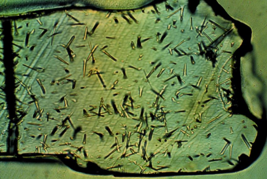
Abstract & Kurzfassung

                                          Abstract

   The role of feedback between erosional unloading and tectonics controlling the
development of the Himalaya is a matter of current debate. The distribution of precipitation is
thought to control surface erosion, which in turn results in tectonic exhumation as an isostatic
compensation process. Alternatively, subsurface structures can have significant influence in
the evolution of this actively growing orogen.
                                                 40
   Along the southern Himalayan front new             Ar/39Ar white mica and apatite fission track
(AFT) thermochronologic data provide the opportunity to determine the history of rock-uplift
and exhumation paths along an approximately 120-km-wide NE-SW transect spanning the
                                                            40
greater Sutlej region of the northwest Himalaya, India.          Ar/39Ar data indicate, consistent with
earlier studies that first the High Himalayan Crystalline, and subsequently the Lesser
Himalayan Crystalline nappes were exhumed rapidly during Miocene time, while the
deformation front propagated to the south. In contrast, new AFT data delineate synchronous
exhumation of an elliptically shaped, NE-SW-oriented ~80 x 40 km region spanning both
crystalline nappes during Pliocene-Quaternary time. The AFT ages correlate with elevation,
but show within the resolution of the method no spatial relationship to preexisting major
tectonic structures, such as the Main Central Thrust or the Southern Tibetan Fault System.
Assuming constant exhumation rates and geothermal gradient, the rocks of two age vs.
elevation transects were exhumed at ~1.4 ±0.2 and ~1.1 ±0.4 mm/a with an average cooling
rate of ~50-60 °C/Ma during Pliocene-Quaternary time. The locus of pronounced exhumation
defined by the AFT data coincides with a region of enhanced precipitation, high discharge,
and sediment flux rates under present conditions. We therefore hypothesize that the
distribution of AFT cooling ages might reflect the efficiency of surface processes and fluvial
erosion, and thus demonstrate the influence of erosion in localizing rock-uplift and
exhumation along southern Himalayan front, rather than encompassing the entire orogen.

   Despite a possible feedback between erosion and exhumation along the southern
Himalayan front, we observe tectonically driven, crustal exhumation within the arid region
behind the orographic barrier of the High Himalaya, which might be related to and driven by
internal plateau forces. Several metamorphic-igneous gneiss dome complexes have been
exhumed between the High Himalaya to the south and Indus-Tsangpo suture zone to the
north since the onset of Indian-Eurasian collision ~50 Ma ago. Although the overall tectonic
setting is characterized by convergence the exhumation of these domes is accommodated by
extensional fault systems.

   Along the Indian-Tibetan border the poorly described Leo Pargil metamorphic-igneous
gneiss dome (31-34°N/77-78°E) is located within the Tethyan Himalaya. New field mapping,
structural, and geochronologic data document that the western flank of the Leo Pargil dome
was formed by extension along temporally linked normal fault systems. Motion on a major
detachment system, referred to as the Leo Pargil detachment zone (LPDZ) has led to the

                                            - I -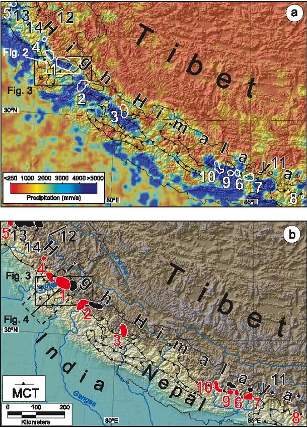
Dissertation of Rasmus C. Thiede

juxtaposition of low-grade metamorphic, sedimentary rocks in the hanging wall and high-
                                                                                40
grade metamorphic gneisses in the footwall. However, the distribution of new         Ar/39Ar white
mica data indicate a regional cooling event during middle Miocene time. New apatite fission
track (AFT) data demonstrate that subsequently more of the footwall was extruded along the
LPDZ in a brittle stage between 10 and 2 Ma with a minimum displacement of ~9 km.
Additionally, AFT-data indicate a regional accelerated cooling and exhumation episode
starting at ~4 Ma.

   Thus, tectonic processes can affect the entire orogenic system, while potential feedbacks
between erosion and tectonics appear to be limited to the windward sides of an orogenic
systems.

                                     Kurzfassung

   Welche Rolle Wechselwirkungen zwischen der Verteilung des Niederschlags, Erosion und
Tektonik während der Entwicklung des Himalayas über geologische Zeiträume gespielt haben
bzw. heute spielen, ist umstritten. Dabei ist von besonderem Interesse, ob Erosion
ausschliesslich in Folge tiefkrustaler Hebungsprozesse entsteht und gesteuert wird, oder ob
Regionen besonders effektiver Erosion, bedingt durch isostatische Kompensation, die
Lokation tektonischer Deformation innerhalb aktiver Orogene beeinflussen können.
                                                                                        40
   Entlang der südlichen Himalayafront ermöglichen neue thermochronologische                 Ar/39Ar-
Hellglimmer- und Apatite-Spaltspur-Alter die Bestimmung der Exhumationspfade entlang
eines 120-km-langen NE-SW-gerichteten Profils, dass quer durch die gesamte Sutlej-Region
                                                                         40
des nordwestlichen, indischen Himalayas verläuft. Dabei deuten die            Ar/39Ar-Daten in
übereinstimmung mit früheren Studien darauf hin, dass zuerst das Kristallin des Hohen
Himalayas und anschliessend, südwärts propagierend, das Kristallin des Niederen Himalayas
während des Miozäns exhumiert worden ist. Im Gegensatz dazu weisen die neuen Apatit-
Spaltspur-Alter auf eine gleichmässige und zeitgleiche Exhumation beider kristallinen Decken
entlang des Sutlejflusses. Dieser 80x40 km weite Bereich formt einen elliptischen, nordost-
südwest orientierten Sektor erhöhter Exhumationsraten während des Pliozäns und Quartärs.
Innerhalb des Fehlerbereichs der Spaltspurmethode zeigen die Alter eine gute Korrelation mit
der Höhe, zeigen aber gleichzeitig keine Abhängigkeit zu bedeutenden tektonischen
Störungen, wie die „Main Central Thrust“ oder dem „Southern Tibetan Fault System“. Unter
der vereinfachten Annahme konstanter Exhumationsraten deuten zwei verschiedene
Höhenprofile auf Exhumationraten in der Grössenordnung von ~1,4 ±0,2 und ~1,1 ±0,4 mm/a
bei einer durchschnittlichen Abkühlrate von ~50-60 °C/m.y. während des Pliozäns bzw.
Quartärs hin. Der anhand von Spaltspuraltern bestimmte Sektor verstärkter Exhumation
korreliert mit dem Gebiet, das während des Holozäns hohen Niederschlags-, Erosion- bzw.
Sedimenttransportraten ausgesetzt ist. Daher vermuten wir, dass die Verteilung von jungen
Spaltspuraltern den regionalen Grad der Effiziens von Oberflächenprozessen und fluviatiler
Erosion wiederspiegelt. Dies deutet auf einen Zusammenhang zwischen Erosion und der

                                          - II -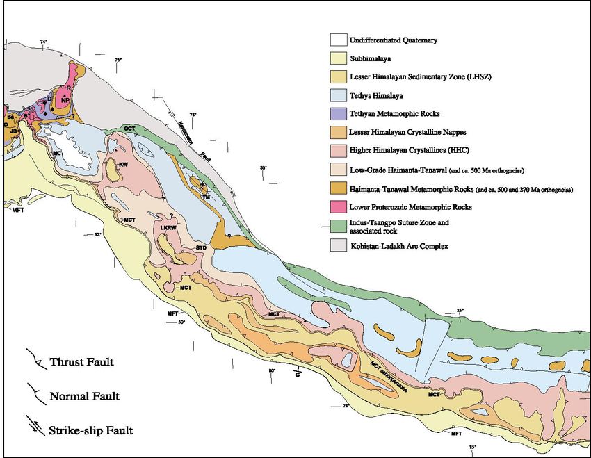
Abstract & Kurzfassung

Lokalisierung von Hebung und Exhumation entlang der südlichen Front des Himalayas hin,
und zeigt gleichzeitig, dass die Exhumation nicht einfach über die gesamte Front
gleichmässig verteilt ist.

   Trotz der Wechselwirkungen zwischen Exhumation und Erosion, die möglicherweise die
Entwicklung der südlichen Himalayafront beeinflussen, beobachten wir auch tiefkrustale
tektonische Exhumation in ariden Gebieten nördlich des Hohen Himalayas, die vermutlich im
Zusammenhang mit plateauinternenen Deformationsprozessen steht. So haben sich zum
Beispiel mehrere metaplutonische Gneissdomkomplexe zwischen dem Hohen Himalaya im
Süden und der Indus-Tsangpo Suturzone im Norden seit der Indien-Asien Kollision vor ca. 50
Millionen Jahren entwickelt. Obwohl die Dome sich grossräumig in einem kommpressiven
Spannungsfeld befinden, werden sie lokal entlang von Extensionsstrukturen exhumiert. Bis
heute sind die Ursachen für die Entstehung dieser Prozesse umstritten.

   Entlang    der    Indisch-Tibetischen    Grenze        erstreckt   sich   der   fast   vollkommen
unbeschriebene Leo-Pargil-Gneissdomkomplex (31-34°N/77-78°E) innerhalb des Tethyschen
Himalayas. Neue Geländekartierungen, strukturelle und geochronologische Daten der
westliche Flanke des Leo Pargil Domes dokumentieren, dass dieser sich entlang zeitlich
verbundener Abschiebungssysteme in einem extensionalen Regime entwickelt hat. Im
Gelände wird der Dome von einem mächtigen Störungssystem begrenzt, die “Leo Pargil
Detachment Zone” (LPDZ). Durch den tektonischen Versatz entlang der LPDZ liegen heute
niedriggradig metamorphe Sedimentgesteine im Hangenden neben hochgradigen Gneisen in
Liegenden.     Unabhängig     von   der     Probenlokation       entlang     des   aufgeschlossenen
                                           40      39
Störungssystemes ergeben alle neuen             Ar/ Ar-Hellglimmeralter um die 15 Ma und deuten
auf ein regional wichtiges Abkühlungsereignis hin. Im Gegensatz dazu deuten die neuen
Apatit-Spaltspuralter (AFT) auf eine kontinuierliche Exhumation der hochmetamorphen
Einheiten im Liegenden der LPDZ unter sprödtektonischen Bedingungen zwischen 10 und 2
Ma hin, bei einem minimalen Versatz von ungefähr 9 km. Desweiteren deuten die Apatit-
Spaltspur-Daten auf überregionale beschleunigte Abkülhlungs- bzw Exhumationsphase seit 4
Ma.

Daraus kann gefolgert werden, dass die tektonischen Prozesse die Entwicklung des
gesamten Gebirges beflussen können, während potenzielle Wechselwirkungen zwischen
Erosion und Tektonik auf die luvwärtigen Gebirgsflanken beschränkt zu bleiben scheinen.

                                                - III -
Dissertation of Rasmus C. Thiede

                                                               Table of Contents
Abstract..........................................................................................................................................................I
Kurzfassung..................................................................................................................................................II
Table of Contents ....................................................................................................................................... IV
Table of Figures........................................................................................................................................... V
Preface ....................................................................................................................................................... VI
Acknowledgements ................................................................................................................................... VII
   1.         Introduction.......................................................................................................................................1
   2.         The Himalaya-Tibetan orogen .........................................................................................................7
        2.1           Indus-Yalu suture zone ............................................................................................................8
        2.2           The Tethyan Himalaya .............................................................................................................8
        2.3           The Himalayan crystalline core................................................................................................9
        2.4           The Lesser Himalaya ...............................................................................................................9
        2.5           Sub-Himalayan zone..............................................................................................................10
   3.         Erosion and Rock Uplift in Orogenesis ..........................................................................................11
   4.         Dating Methods ..............................................................................................................................14
        4.1           40
                        Argon/39Argon......................................................................................................................14
        4.2           Apatite Fission Track (AFT) ...................................................................................................15
        4.3           Uranium/Thorium-Helium (U/Th-He)......................................................................................17
   5.         Climatic Control on Rapid Exhumation Along the Southern Himalayan Front..............................20
        5.1           Abstract ..................................................................................................................................20
        5.2           Introduction.............................................................................................................................21
        5.3           The Himalaya .........................................................................................................................26
        5.4           Apatite Fission Track Analysis ...............................................................................................28
        5.5           Interpretation ..........................................................................................................................30
        5.6           Discussion ..............................................................................................................................31
        5.7           Conclusions............................................................................................................................36
        5.8           Acknowledgements ................................................................................................................37
   6.         From tectonically to erosionally controlled development of the Himalayan fold-and-thrust belt…
              ………………………………………………………………………………………………..38
        6.1           Abstract ..................................................................................................................................38
        6.2           Introduction.............................................................................................................................38
        6.3           Geologic setting of the northwestern Himalaya.....................................................................41
        6.4           Thermochronologic Data........................................................................................................41
        6.5           From diachronous to synchronous cooling of the Himalayan crystalline core......................45
        6.6           Geodynamic Implications and Conclusions...........................................................................45
        6.7           Acknowledgment....................................................................................................................46
        6.8           Appendix ................................................................................................................................46
              6.8.1          Thermochonology ..........................................................................................................46
   7.         Mid Miocene to Recent E-W Extension in the Tethyan Himalaya, Leo Pargil Dome, NW-India
              ………………………………………………………………………………………………….48
        7.1           Abstract ..................................................................................................................................48
        7.2           Introduction.............................................................................................................................49

                                                                          - IV -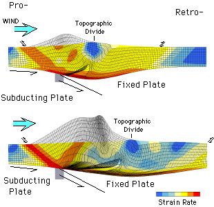
Table of Contents
7.2.1 The Himalayan-Tibetan orogen .....................................................................................52
7.2.2 Karakorum Fault system................................................................................................53
7.2.3 Mid to late Miocene normal and strike-slip-faulting .......................................................53
7.3 Methods..................................................................................................................................54
7.3.1 Low-Temperature Thermochronology ...........................................................................54
7.4 The Leo Pargil Dome .............................................................................................................59
7.4.1 Rock types and structures of the LPDZ-footwall ...........................................................60
7.4.2 Hanging wall rocks of the Leo Pargil detachment fault .................................................62
7.4.3 Kaurik-Chango normal fault zone ..................................................................................63
7.5 Age constraints ......................................................................................................................64
7.5.1 Lower Spiti valley traverse.............................................................................................65
7.5.2 40
Ar/39Ar-Thermochronology ..............................................................................................66
7.6 Discussion ..............................................................................................................................68
7.7 Acknowledgments ..................................................................................................................71
8. Conclusions ....................................................................................................................................72
9. References .....................................................................................................................................75
Table of Figures
Fig. 1. Coupled finite element model for deformation and erosion (after Willett, 1999)..............................1
Fig. 2. Nasa satellite image of the Himalaya. ..............................................................................................4
Fig. 3 Tectonic overview map of the Himalaya (after DiPietro and Pogue, 2004 and ref. therein).............7
Fig. 4. Calculated cooling age pattern of the U/Th-He and apatite fission track. ......................................16
Fig. 5: Photomicrograph of etched apatite crystals showing randomly distributed fission tracks .............16
Fig. 6. Photomicrographs of apatite crystals by Ehlers and Farley (2003).. .............................................18
Fig. 7. The influence of α ejection on the apatite He ages after Ehlers and Farley (2003).. ....................18
Fig. 8: GTOPO30 (USGS) map of Himalayas showing selected areas of young cooling ages................23
Fig. 9: a) Distribution of new apatite fission track ages across the Himalayan Crystalline Core. .............25
Fig. 10: Compiled AFT cooling ages across the crystalline core of the Himalaya (NW India)..................27
Fig. 11: a) NE-SW profiles showing the topography, precipitation, geology, exhumation, and
metamorphism across the High Himalaya.. .......................................................................................33
Figure 12: Compiled AFT cooling ages across the Himalayan crystalline core ........................................40
Figure 13. Spectra and inverse isochron diagrams of the 40Ar/39Ar measurements. ................................42
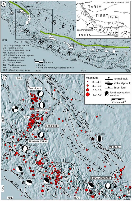
Fig. 14: Distibution of Northern Himalaya gneiss domes and major faultsystems of the Himalaya and
Southern Tibet superposed on shaded relief (GTOPO 30 USGS). B shows major faults and
seismicity of the NW-Himalaya and Southern Tibet ........................................................................50
Fig. 15: Geologic map of the western flank of the Leo-Pargil dome. ........................................................55
Fig. 16: a) View of the Leo Pargil dome to the E of the Kaurik-Chango normal fault zone. .....................56
Fig. 17. E-W transect across the western flank of the Leo Pargil dome. ..................................................57
Fig. 18: a) View of the Leo Pargil detachment zone..................................................................................60
Fig. 19: Quartzitic mylonite at the base of the LPDZ hanging wall ..........................................................61
Fig. 20: WNW-ESE geologic cross section near Sumdo...........................................................................62
Fig. 21. Time-temperature modeling results obtained with AFT-Solve and track-length population ........65
Fig. 22. Apatite fission track ages plotted versus horizontal distance perpendicular to the Kaurik-Chango
normal fault (A) and versus elevation (B). .........................................................................................66
- V -
Dissertation of Rasmus C. Thiede

Figure 23. 40Ar/39Ar age isochron and spectra diagrams for muscovite and biotite from rocks in the
     footwall of the Leo-Pargil detachment system...................................................................................67

                                                    Table of Tables
Table 1. Summary of published cooling ages from the southern Himalayan front. ..................................24
Table 2: Apatite fission track data from the Sutlej Region, see Fig. 9.......................................................26
Table 3: Apatite fission track data , see Fig. 12D for location. ..................................................................44
Table 4: Apatite fission track data from the Leopargil Region, see fig. 15 for location. ............................58

                                                           Preface

    When I first visited India in 1997 as a field assistant to a field campaign of my Austrian
friends and colleagues from Vienna, I immediately fell in love with both India and the
Himalaya. We worked for six weeks in the remote and highly elevated Spiti and Lahaul, the
northern districts of Himachal Pradesh, north of the High Himalaya. Working in the beautiful
Pin Valley was the highlight of our trip, and at the end I was particularly impressed by the
friendliness of local spiti-people who lived under the simplest of conditions, for hundreds of
years in this breathtaking, mountainous landscape. My experiences and adventures in both
the Himalaya and India, and having the opportunity to meet these people both in the low and
highlands of India, have left a deep impression and fascination for this region of our wonderful
planet. I will treasure these memories for the rest of my life. However, at that time I had never
dreamed of having the opportunity to return to India, and work in the Himalayas for my PhD.

    On our return journey we had to stay in Delhi for several days. In one of the many
bookshops around the Connaught Place I found a 700 hundred page thick biography of
Mahatma Gandhi, reprinted in India and written in English. The people, who know me, know
that I am still to a degree, struggling with the English language. However, I realized that there
is no way to get around English and so I decided that I would do my best to learn it. This book
has accompanied me during my entire graduate studies. My plan was to have finished
reading this book, which I did during my last field season in 2002, before the end of my PhD.

                                                           - VI -
Preface & Acknowledgement
Acknowledgements
I thank my close friend and colleague Bodo Bookhagen for the great time we had together
when carrying out this project. Thanks for the endless discussions, support and enormous
motivation he gave me to do all my work and to go through all highs and lows of the last three
years.
I am especially grateful to Manfred Strecker, my thesis advisor for all his sustained support
and encouragement to help us carry out all parts of our PhD, sharing his great knowledge and
enthusiasm in all kinds of fields of geology.
I thank Ramon Arrowsmith for his support and friendship. Thanks for inviting me not only
to work at ASU but also for his great hospitality and for shearing his house with me for six
months. Thanks for providing these opportunities and allowing me to have a deep detailed
look into his country during difficult times.
I would like to thank Edward Sobel for his patient teaching of the fission track method,
Anke Friedrich for discussion and support, Mike McWilliams for introducing Ar/Ar-Method and
Ken Farley for U/Th-He.
I owe a great deal to conversations and discussions with Arvid Jain, Sandeep Singh from
the IIT Roorkee, India, and all my other Indian friends. My thanks go also to Tashi Tsering
and Ram Singh Slathia, the greatest Indian mountain guides, who made our field time
extremely effective and successful.
Thanks to Bernhard Grasemann, “Jambo” (Christoph) Janda, Christian Hager, Erich
Draganitz for introducing us to the spectacular geology of the Himalaya and joining fieldwork.
I offer my gratitude to Miriam Dühnforth, Estelle Mortimer, Barbara Carrapa, Lindsey
Schoenbohm, Peter Blisniuk, Monica Vasques-Parra, Britta Bookhagen, Michel Knigge, Elina
Zwickert and Angela Landgraf, Esther Hintersberger, Nadja Insel, Jörn Hauer, for help during
fieldwork; to Birgit Fabian, Christine Fischer, Antje Müller and Volkmar, Annette, Silvia and all
the other friends.
I am very grateful to my parents Sigrid und Jörn, all my brothers Hannes, Fridtjof and
Morten, and the rest of my family for their sustained support and help during all phases of this
work.
Finally, I thank the German Research Foundation (DFG) for the financial support (Grant
#STR-11/4) for this project.
- VII -Dissertation of Rasmus C. Thiede
- VIII -Chapter 1: Introduction
1. INTRODUCTION
It had long been established that erosion responds to any deformational change. However,
one of the most important findings over the past two decades has been recognition of a
dynamic coupling between climatically-driven erosion and tectonic processes, which perhaps
can take a first order role during orogen evolution (Beaumont et al., 1992; Beaumont et al.,
1996b; e.g., Koons, 1989; Koons, 1990; Masek et al., 1994; Willett et al., 1993). As a
consequence of collisional tectonics, topography grows and forms orographic barriers, which
then possibly enhance and/or divert global atmospheric circulation and precipitation patterns
(e.g., Dahlen and Suppe, 1988; Hoffman and Grotzinger, 1993; Molnar and England, 1990;
Willett, 1999). Recent field studies in New Zealand’s Southern Alps (Tippet and Hovius,
2000), Taiwan (e.g., Dadson et al., 2003; Willett et al., 2003), the Olympic and Cascade
Mountains in North America (e.g., Brandon et al., 1998; Reiners et al., 2003), the Tien Shan
(Pavlis et al., 1997; Strecker et al., 2003), and the Himalayas (Burbank et al., 2003; Hodges
et al., 2004; Thiede et al., 2004; Wobus et al., 2003; Zeitler et al., 2001a) have documented a
correlation between regions affected by high erosion and exhumation rates. In addition,
analog and numerical simulations using coupled tectonic and surface process models (e.g.,
Beaumont et al., 1992; Beaumont et al., 2001; Hoth et al., revised; Koons, 1989; Koons,
1990; Koons et al., 2002; Whipple and Meade, 2004; Willett, 1999) have demonstrated that
the mechanics of orogens can be powerfully influenced by surface processes. Thereby the
location of erosion with respect to the convergence geometry acts as a first-order parameter
controlling pro-wedge and/or retro-wedge evolution (Beaumont et al., 1992; Willett et al.,
1993; Willett, 1999).
(a) (b)
Fig. 1. Coupled finite element model for deformation and erosion of an orogenic mountain range (after
Willett, 1999). (a) Pro-wedge erosion: precipitation and erosion are focused on the orogenic wedge above the
subducting plate (the pro-wedge). (b) Retrowedge erosion; precipitation and erosion are focused on the
orogenic wedge above the overriding plate (the retro-wedge). Colors show distribution of strain within the
overriding plate; red high strain, blue low strain, grey eroded upper plate.
- 1 -Dissertation of Rasmus C. Thiede
Accordingly, any asymmetry of erosion would have a pronounced influence on the
distribution of deformation and exhumations rates within the wedge (Hoth et al., revised;
Whipple and Meade, 2004). These models have indicated that erosion can control the
distribution and propagation of deformation as well as exhumation within orogenic wedges
(Hoth et al., revised; Whipple and Meade, 2004).
The linkage and feedback between erosion and tectonic setting depends on the efficiency
of erosion (Whipple and Meade, 2004), which is a function of the amount and distribution of
precipitation regulating the fluvial discharge and the tectonic setting producing and sustaining
high topography, steep relief, and longitudinal river profiles over geologic time. On a
continental scale the amount and distribution of precipitation is determined by the relationship
and interaction between orientation of the orogen, the global atmospheric circulation pattern,
and source area of the moisture such as oceans. Regionally, the distribution of topography
and elevation strongly influence the precipitation pattern (Barros and Lettenmaier, 1993;
Barros and Lettenmaier, 1994; Bookhagen et al., in review) and generally erosion processes
are concentrated on the windward slopes of a mountainous region (Willett, 1999). Thus in
conclusion, this wide range of possible preconditions and settings illustrates the high
variability of the efficiency of erosion and tectonic interaction, and the wide range of possible
effects on the evolution of an orogenic system.
Dahlen and Suppe (1988) demonstrated that erosion rate can control the width of a steady
state orogenic wedge, and that deformation patterns are largely influenced by surface
erosion. Analytic solutions for the steady state orogen demonstrate that width, orogen-scale
strain partitioning, and rock-uplift rates are controlled by the mass balance within an orogenic
wedge at flux steady state (Willett and Brandon, 2002). This solution combines the geometric
constraints of the critical taper theory and erosion consistent with this topography to find the
wedge width required to satisfy the mass balance conditions. As an oversimplification for their
models, they assume that erosion is homogenously distributed across the range. However,
several studies have demonstrated that bedrock channels play a key role in determining the
erosion pattern because they dictate much of the relief structure of mountainous regions,
communicate signals of tectonic, climate and eustatic changes across landscapes, and set
regional rates of denudation (Burbank et al., 1996b; Whipple and Tucker, 1999). This implies
that erosion depends on local circumstances rather then regional conditions.
Many geomorphologists assume that erosion rates is controlled by the stream-power
model of bedrock-channel incision (e.g., Hack, 1957; Howard et al., 1994; Howard and Kerby,
1983; Whipple and Tucker, 2002), however the stream-power model should be considered as
a simple, empirical, and incomplete approximation to the behavior of a complex suite of
processes controlling erosion (Hancock et al., 1998; Sklar and Dietrich, 1998; Whipple et al.,
2000; Whipple and Tucker, 2002).
Therefore, if over geologic time a mountain front is affected by sustained high erosion
rates, an orogen can develop towards a flux and topographic steady state where the accretion
- 2 -Chapter 1: Introduction
influx is balanced by the erosional removal of material, thus controlling the orogen width, the
distribution of rock-uplift and exhumation rates, as well as the strain partitioning within the
orogen (Beaumont et al., 1996a; Beaumont et al., 1992; Dahlen and Suppe, 1988; Hoth et al.,
revised; Whipple and Meade, 2004; Willett, 1999).
Climatic, topographic and thermochronologic data from New Zealand’s Southern Alps,
Taiwan’s Central Range, the Olympics and Cascade mountains in North and the Andes in
South America suggest the existence of a link between the distribution of erosion and rock-
uplift rates (Brandon et al., 1998; Koons, 1995; Montgomery et al., 2001; Willett and Brandon,
2002; Willett et al., 2001). Indeed, for example, the dramatic along-strike variability in orogen
width, depth of exhumation, and rock uplift rate that characterize the Andes has been
attributed to along-strike differences in climate (Dahlen and Suppe, 1988; Hilley and Strecker,
2004; Horton, 1999; Masek et al., 1994; Montgomery et al., 2001). Orogen-scale rock uplift
rates are dictated by the erosion rate rather than vice versa, as commonly assumed (Whipple
and Tucker, 1999; Willgoose et al., 1991).
The Himalayan orogen today is the highest, and probably one of the most dynamic
orogens on Earth. It provides outstanding opportunities to improve and test hypothesizes
describing the interaction and feedback between erosion and tectonics. Since the beginning
of continental collision between India and Eurasia, approximately 50 m.y. ago, India has
continued to move northwards relative to a stable Eurasia (e.g., Lefort, 1975; Molnar and
Tapponier, 1975). A convergence rate of approximately 50 mm/yr has resulted in
approximately 2500 km of convergence since the onset of collision (Klootwijk et al., 1985;
Patriat and Achache, 1984), causing continental deformation throughout central and south-
east Asia and forming the Himalayan orogenic wedge along the southern termination of the
Tibetan Plateau.
- 3 -Dissertation of Rasmus C. Thiede
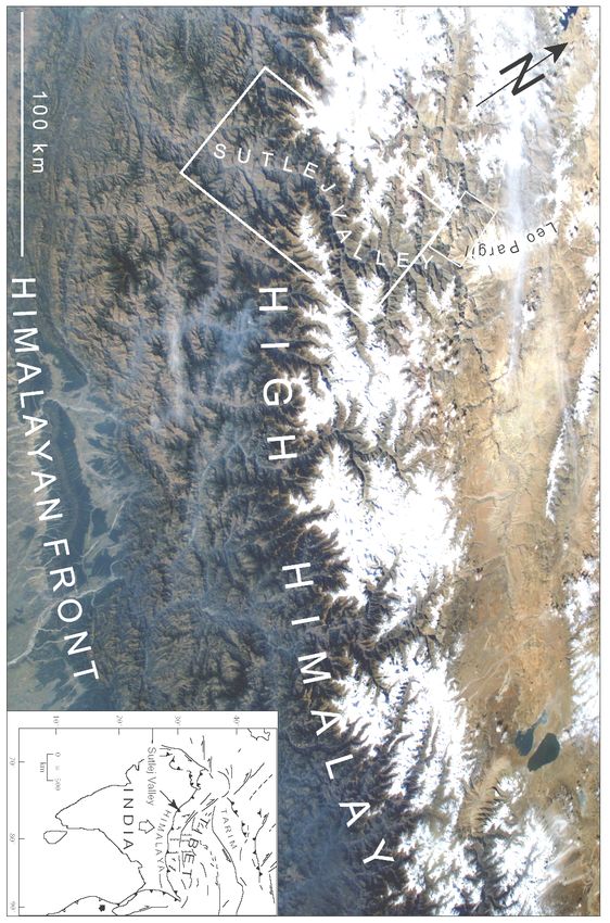
Fig. 2. (a) Terra satellite image of the Himalaya looking towards the N from the Nasa (Astronaut Photography
of Earth ISS007_ISS007-E-16052). To the south humid and vegetated southern Himalayan front (dark colors)
and the norht, arid and unvegetated sectors (light colors) to the north of the Himalayan orographic barrier.
White boxes show study arias.
- 4 -Chapter 1: Introduction
As a consequence of extended continual deformation and formation of Tibetan Plateau,
the atmospheric global circulation pattern was modified, and the Asian monsoon was
established in the late Miocene (Dettman et al., 2003; Dettman et al., 2001). However, vast
sedimentary basins have been filled since the Miocene, such as the Himalayan foreland basin
(Burbank et al., 1996a), the Bengal and Indus fan, respectively, (Clift et al., 2002; Einsele et
al., 1996; Metivier et al., 1999). Thus, the Himalaya must have formed an important
orographic barrier, which has been affected by sustained high precipitation, erosion, and
sediment-flux rates since that time. Previously, any erosional impact on the evolution of the
Himalayan orogen had been neglected, and researchers assumed that erosion responds
primarily to deformational change, such as the establishment of new thrust systems (e.g.,
Meigs et al., 1995). However, more recent Himalayan orogen-scale studies assume a close
feedback between erosion and exhumation although the effects of erosion on the geodynamic
evolution of the southern Himalayan front remain highly controversial (Burbank et al., 2003;
Hodges et al., 2004; Thiede et al., 2004; Vannay et al., 2004; Wobus et al., 2003; Zeitler et
al., 2001a). This controversy between the role of tectonics, erosion, exhumation and climate
constitutes the fundamental motivation for undertaking this thesis. Raising the following open
questions formed the framework to my work.
1. Do we find constraints to role out any erosional impact on the geodynamic evolution of
the Himalaya?
2. Are erosion rates homogeneously distributed throughout the entire southern Himalayan
front, or if not, what kind of consequences on the kinematic evolution of the orogen are
expected?
3. How well can deformation compensate a regionally focused distribution of erosion?
4. How and where is the erosion in an orogen most efficient and concentrated?
5. Is rock uplift rate more strongly controlled by erosional efficiency or by accretionary flux?
6. It has remained unclear whether the details of the erosion processes (e.g., climatic
variablity controlling erosion processes on different time scales between 100 and 105
years) are important to the geodynamic evolution of the orogen?
7. How localized can erosion be while still having an effect on the uplift rates, or how
localized can exhumation be compensate for localized erosion, on a 100, 101, or 102 km
scale?
8. What is the primary control on the evolution of the orogen: the architecture of the
orogenic wedge or the distribution of precipitation and erosion?
In order to address these questions I used low-temperature thermochronology such as
40
apatite fission track (AFT), Ar/39Ar also U/Th-He to constrain the average long-term cooling
rates of a rock column relative to the thermal isogrades. Thereby I used the circumstance that
- 5 -Dissertation of Rasmus C. Thiede
the different geochronometers have different closure temperatures (Dodson, 1973) to place
constraints on the temporal movement of the rocks passing specific temperatures on their
cooling pass through the upper crust. Using low-temperature thermochronology provides the
opportunity to date the youngest rock-exhumation and thus potentially cooling affected by
surface processes such as river incision. Even if these methods do not provide any direct
measurement or constraints on regional surface uplift rates, they provide age data that may
be related to relative rock-uplift and exhumation via the concept of closure temperatures
(Dodson, 1973). In my study rock-uplift and exhumation rates were analyzed across a 120-
km-long SW-NE transect normal to the strike of the NW-Himalayan orogen in India. As a
second study, the poorly known Leopargil metamorphic gneiss dome and its structural
evolution and exhumation was documented with help of new geologic mapping, collected
40 39
structural data, and AFT and Ar/ Ar-analysis constraining the timing of exhumation. My
results and conclusions are subdivided into three publications presented here in the form of
three chapters.
First, I investigated whether along the southern front of the High Himalaya a correlation
between areas of rapid rock-uplift and exhumation and recent focused precipitation exists. As
discussed above, the recent global atmospheric circulation pattern was established during the
late Miocene (Dettman et al., 2003; Dettman et al., 2001), and I therefore assumed a
sustained distribution of precipitation and erosion over geologic time. As a consequence of
sustained focused erosion affecting the Himalaya, the orogenic wedge is compensating the
erosional removal by high rock-uplift and exhumation rates indicating that erosion guides the
exhumation along the southern Himalayan front (chapter 5).
Second, the compilation of my own and published thermochronology data and exhumation
paths reveals important implications for the geodynamic evolution of the Himalayan orogenic
wedge, and suggests a transition from a growing and propagating to a semi-stagnating
orogenic wedge (chapter 6).
The third study describes the geodynamic evolution and exhumation of the Leopargil
metamorphic gneiss dome. There, I was able to demonstrate that the Leopargil dome
developed as a consequence of sustained E-W extension since middle Miocene time. Our
results have important implications for testing models that are trying to explain the observed
deformation pattern of the southern Tibetan Plateau (chapter 7).
- 6 -Chapter 2: The Himalayan Tibetan Orogen
2. THE HIMALAYA-TIBETAN OROGEN
The Himalayan fold and thrust-belt is situated between the Indian shield to the south and
the Indus-Tsangpo suture zone to the north (Fig. 2). Since the onset of collision between
Eurasia and India, four major north-dipping thrust systems have primarily controlled the
evolution of the Himalayan orogenic wedge: the Southern Tibetan Fault System (STFS), Main
Central Thrust (MCT), Main Boundary Thrust (MBT), and the Main Frontal Thrust (MFT; Fig.
3). Balanced cross-sections and seismicity data indicate that the MFT and MBT fault systems
are rooted in a low angle, basal detachment, referred to as the Main Himalayan Thrust (MHT),
which has detached all major Himalayan tectonostratigraphic domains from the
underthrusting Indian plate and incorporated them into the orogen (Brunel, 1986; DeCelles et
al., 2001; Molnar and Lyon-Caen, 1989; Schelling, 1992; Schelling and Arita, 1991;
Srivastava and Mitra, 1994). Whether or not the Main Central Thrust and Southern Tibetan
Fault system also root into this basal detachment system, as previously assumed, has been
called into question (Searle and Godin, 2003; Searle et al., 2003).
Fig. 3 Simplified tectonic map of the central and western Himalaya (after DiPietro and Pogue, 2004 and ref.
therein). Major faults from south to north are Main Frontal Thrust (MFT), Main Boundary Thrust (MBT), Main
Central Thrust (MCT), Southern Tibetan Faults System (STFS), Great Counter Thrust System (GCT). Other
faults and location from east to west are Indus Syntaxis (IS), Oghi Fault (O), Banna Fault (Ba), Jhelum-
Balakot Fault (JB), Batal Fault (B), Diamir Fault (D), Raikot Fault (R), Nanga Parbat (NP), Jammu Thrust (JT),
Tso Morari region (TM), Kishtwar Window (KW), Larji-Kulu-Rampur-Window (LKRW).
- 7 -Dissertation of Rasmus C. Thiede
The crustal faults bound the Himlayan tectonostratigraphic domains that are exposed
along the entire length of Himalayan chain (Fig. 3): (a) Indus-Yarlung suture zone (b) Tethyan
Himalaya (c) the Himalayan crystalline core, (d) Lesser or Lower Himalaya (LH), (e) the Sub-
Himalaya (SubH).
2.1 Indus-Yalu suture zone
The Indus-Yalu suture zone forms the geologic boundary between rocks related to the
Indian plate to the south and the Eurasian plate to the north, and contains ophiolites and
associated rocks of the Neo-Tethys Ocean. Where the suture zone is preserved, it is bounded
by two Cenozoic thrusts. Along the northern side, the north-dipping Gangdese thrust
(Harrison et al., 1992; Yin et al., 1994) is juxtaposes the Gangdese batholith over suture-zone
rocks or the Xigaze forearc strata. Between 30 Ma and 24 Ma the displacement along the
Gangdese thrust caused extensive denudation of the Gangdese batholith in its hanging wall,
and underthrusting of the Xigaze forearc strata in its footwall (Yin et al., 1999; Yin et al.,
1994). Along the southern side, the younger south-dipping Great Counter Thrust is
juxtaposing the Tethyan Himalaya over the melange complex associated with the suture zone
(Heim and Gansser, 1939; Ratschbacher et al., 1994). The thrust was active at least during
the Miocene, although its timing is still poorly constrained (Quidelleur et al., 1997; Yin et al.,
1999).
2.2 The Tethyan Himalaya
To the south follows the Tethyan Himalaya situated between the Southern Tibetan Fault
System and the Great Counter Thrust. The Tethyan Himalaya consists of late Precambrian to
lower Paleozoic sedimentary and metasedimentary rocks (Burchfiel et al., 1992; Gansser,
1964; Steck et al., 1993) and a thick Permian to Eocene continental-margin sequences (e.g.,
Brookfield, 1993; Steck, 2003 and ref. therein). The entire sequence is commonly referred to
as the Tethyan Sedimentary Sequence. These sediments were generally affected by only
very low-grade metamorphic conditions as a consequence of thin-skinned tectonics forming
the Tethyan fold-and-thrust belt early, Eo-Himalayan stages of shortening (e.g., Ratschbacher
et al., 1994; Wiesmayr and Grasemann, 2002). The age of deformation generally decreases
from north to south, from the late Eocene to the early Oligocene. At least three major SW
directed nappe structures developed in the NW-Himalaya due to upper crustal deformation
during underthrusting (i.e., the Tso Morari, Tetraogal, and Mata Nappes) (Steck et al., 1998).
The appearance of schists and gneisses in the Tethyan Himalaya are interpreted to be
associated with tectonic displacement and exhumation on syn-collisional extensional
structures such as the Gurla Mandhata (Murphy et al., 2002), Kangmar Dome (Chen et al.,
1990; Lee et al., 2000), and the Leo Pargil Dome (this study), which postdate the Tethyan
fold-and-thrust belt. Gneiss domes have been interpreted as representing the footwall ramp of
the Main Central Thrust (Wu et al., 1998). Along the Sutlej section, the base of the Tethyan
Himalaya consists mainly of metapelites and metapsammites derived from a thick and
homogeneous sequence of upper Proterozoic to lower Cambrian siltstones and sandstones
- 8 -Chapter 2: The Himalayan Tibetan Orogen
that are intruded by the Kinnaur Kailash Granite, which yielded Rb-Sr ages of 453 ± 9 Ma and
477 ± 29 Ma (Kwatra et al., 1999).
2.3 The Himalayan crystalline core
The Himalayan crystalline core is exposed between the Southern Tibetan Fault System
and the Munsiari Thrust, a thrust system in the footwall of the Main Central Thrust. In the NW-
Himalaya the Himalayan crystalline core is composed of two distinct lithotectonic gneiss units
that are characterized by different cooling histories (Srivastava and Mitra, 1994; Valdiya,
1980b; Vannay and Grasemann, 1998, 2001b) (Fig. 3). The upper unit corresponds to the
High Himalaya Crystalline Sequence (HHCS), a thick, NE-dipping sequence of highly
deformed, amphibolite facies to migmatitic ortho- and para-gneisses. The HHCS is bounded
at its base by the MCT (Catlos et al., 2001; Coleman, 1998; Hubbard and Harrison, 1989) and
at its top by the STDS (Burchfiel et al., 1992; Burg et al., 1984a; Dezes et al., 1999). Toward
the foreland, the MCT becomes a shallow-dipping thrust, separating the HHCS from the low-
to medium-grade metamorphic sediments of the Lesser Himalaya. However, in some
Himalayan sections, a gradual metamorphic transition is observed between the HHCS and
the base of the Tethyan Himalaya (Frank et al., 1995), and these units are characterized by
comparable Sr, Nd and O isotopic signatures (Ahmad et al., 2000; Robinson et al., 2001).
Thus it has been interpreted that the HHCS para- and orthogneisses mostly represent
metamorphic equivalents of the Upper Proterozoic to Cambrian sediments that form the base
of the Tethyan Himalaya. These units are intruded by Cambro-Ordovician granitic plutons.
Beneath the MCT, the lower unit of the Himalayan crystalline core is predominantly composed
of amphibolite facies augen- and paragneisses that are related to the Lesser Himalayan
Crystalline Sequence (LHCS). The base of the LHCS is bounded by the Munsiari Thrust
40
(Valdiya, 1980b; Vannay and Grasemann, 1998). Ar/39Ar-data constrain a late Miocene to
present kinematic evolution and exhumation along the Munsiari Thrust (Copeland and
Harrison, 1990; Metcalfe, 1993; Vannay et al., 2004).
2.4 The Lesser Himalaya
The Lesser Himalaya is bounded by the Main Boundary Thrust at the base and by the
Main Central Thrust at the top, and consists mainly of Precambrian clastic sediments and
medium-grade metasedimentary rocks, granitic gneisses, and granites (Brookfield 1993).
Crystalline nappes forming complex synformal klippes that have been thrusted southward
over less metamorphosed Lesser Himalayan sequence rocks have been associated with
erosional outliers of the High Himalayan Crystalline (Gansser, 1964; Stöcklin, 1980; Schelling,
1992) or the Lesser Himalayan Crystalline (Valdiya, 1980b). The contact to the Subhimalaya
is marked by north-dipping, cataclastic faults, which are associated with the Main Boundary
thrust system (DeCelles et al., 2001; Huyghe et al., 2001; Srivastava and Mitra, 1994). On the
basis of sedimentation patterns in the Subhimalayan zone, Meigs et al. (1995) suggested that
the MBTS may have developed as early as 11-9 Ma. Along the Sutlej Valley the Lesser
Himalaya sequence mainly consists of massive quartz-arenites intruded by basalts dated at
- 9 -Dissertation of Rasmus C. Thiede
1800 ± 13 Ma (Miller et al., 2000).
2.5 Sub-Himalayan zone
The Sub-Himalayan zone is defined as a 10- to 25-km-wide belt of Neogene and
Quaternary molasse sediments exposed between the Main Boundary Thrust and the Main
Frontal Thrust system (e.g.,Burbank et al., 1996a; DeCelles et al., 1998b; Yeats et al., 1992).
The Subhimalaya forms the southern toe of the Himalayan orogenic wedge. In general, two
stratigraphic sequences have been described: (1) the uppermost Paleocene or lower Eocene
to lower Miocene siltstones and sandstones of the Rawalpindi Group, and the (2) lower
Miocene to Pleistocene, upward coarsening succession of fluvial siltstones, sandstones and
conglomerates of the Siwalik Group (Burbank et al., 1996a). Paleocurrent data and sediment
petrographic analyses indicate that these rocks were derived from the southern front of the
developing Himalayan fold-and-thrust belt and deposited within the flexural foredeep on the
Himalayan foreland basin (DeCelles et al., 1998a; DeCelles et al., 1998b). The Main Frontal
thrust system is interpreted to form the surface expression of a low-angle, basal thrust with no
basement involvement, along which the Indian plate is subducted beneath the Himalaya and
southern Tibet (Molnar, 1984; Yeats and Lillie, 1991). There is no direct geologic evidence
related to the initiation age of slip on the Main Frontal thrust system, although it is usually
assumed to be a Pliocene-Holocene structure (Molnar, 1984).
- 10 -Chapter 3: Erosion and Rock Uplift in Orogenisis
3. EROSION AND ROCK UPLIFT IN OROGENESIS
At the orogen-scale, erosion and rock-uplift are intimately linked. Analog and numerical
models simple orogenic systems reveal the nature of this linkage (Beaumont et al., 2001;
Hoth et al., revised; Whipple and Meade, 2004; Willett, 1999). These models assume that an
orogen is of constant width, isostatically compensated, deformed by homogeneous pure
shear deformation, and has a fixed accretionary influx rate. Without erosion, the near-surface
rock uplift rate is determined by the isostatic compensation of crustal thickening (Whipple and
Meade, 2004). The orogenic wedge will develop by internal shortening, where rocks in the
hinterland are uplifted to an elevation at which the gravitational potential energy reaches a
critical level (Dahlen, 1990; Dahlen and Suppe, 1988). To accommodate further shortening
beyond this critical point, the deformation will propagate toward the foreland, and as a
consequence the orogenic wedge also grows and propagates foreward.
In models where erosion increases with topographic slope angle or relief, the system
evolves to a steady state when the topographic slope has increased such that erosional efflux
matches the accretionary influx. Under these conditions, all accreted material is removed via
the surface rather than being stored in the crustal root, and steady-state rock uplift rate
increases by a factor of ~6 (Molnar and England, 1990). As a possible consequence
deformation is localized on the same structures for a long duration, preventing the
propagation of deformation. In this case rock uplift is primarily a response to erosion. Thus the
relative efficiency of erosion on the orogen exerts a fundamental control on steady state
wedge width, topographic relief, and patterns of internal deformation within the wedge.
Dynamic coupling between erosional efficiency and rock-uplift rate can only occur where the
intensity of spatial distribution of erosion can induce a concentration of strain, either through a
narrowing of the orogen or through the development of discrete shear zones that
accommodate focused erosion by thrust advection of material, as seen in some coupled
thermomechanical surface process models (Beaumont et al., 1996a; Willett, 1999). Thereby
the critical taper theory (Dahlen, 1990; Dahlen and Suppe, 1988; Dahlen et al., 1984; Davis et
al., 1983) provides the framework for considering how erosional efficiency may influence
orogen width, rock uplift rate, and deformation within the wedge, allowing an exploration of
the dynamic coupling between climate-driven erosion and tectonics.
However, the role of the controlling parameters that place constraints on the distribution of
erosion over geologic time scale remains controversial. For example, how strongly is the
distribution of erosion influenced by the distribution of precipitation across an orogen? Most
geomorphologists believe that river incision rates are constrained by the relationships of the
stream-power-law (Hack, 1957; Howard, 1998; Howard et al., 1994). Thereby the average
fluvial discharge is controlled both by the precipitation pattern, by the size of the catchment
area, and average gradient and width of the longitudinal river profiles. However, the
topography and climate can strongly influence the distribution of precipitation and potentially
- 11 -Dissertation of Rasmus C. Thiede
cause high discharge rates to occur in comparatively small catchment areas (Barros and
Lettenmaier, 1994). In addition, fluvial runoff and sediment-flux rates are positively correlated
(Bookhagen et al., in review). Over geologic timescales the distribution and amount of
precipitation are subjected to climatically controlled fluctuations. During phases of enhanced
precipitation increased sediment flux and higher frequency of flood events are expected to
create favorable conditions for deep-seated river incision and erosion. Enhanced discharge
and sediment flux provides increased erosive tools, which strengthens the fluvial bedrock
incision by exceeding the critical boundary threshold of the boundary shear stress (e.g., Sklar
and Dietrich, 2001; Snyder et al., 2003; Tucker and Slingerland, 1997). Modeling and field
studies illustrate that increased discharge and sediment flux results in lateral undercutting and
oversteepening of hillslopes (e.g., Hancock and Anderson, 2002). Thus, annual to millennial
climate variations can have a strong influence on variations in erosion and sediment flux
rates, because enhanced precipitation increases groundwater pore pressure and therefore
lowers hillslope stabilities, and may thus trigger large landslides and debris flows (Bookhagen
et al., in press). These relationships indicate a direct and close link between precipitation and
erosion affecting the evolution of tectonically active orogens.
Any tectonic uplift within an orogen leads to a steepening of topography and
disequilibrated longitudinal river gradients (Burbank et al., 1996b; Leland et al., 1998). This
forces fluvial erosive processes continually to incise by trying to adjust to a longitudinal
equilibrium line, which causes massive denudation combined with high sediment flux rates.
Numerous isotopic studies of river, delta and Bengal submarine fan sediments indicate that
rivers draining the Himalaya contribute a significantly larger share of the dissolved and
particulate loads than rivers draining the Indian shield (Galy and France-Lanord, 2001; Galy
et al., 1999). A second major pattern to emerge is the dominant role of summer monsoon
precipitation in controlling water discharge and sediment supply with approximately 80 - 95%
of the total material being delivered in only the 4 months of the Indian summer monsoon
(Barros et al., 2000). This causes a strong seasonal runoff variation of the large river systems
leaving the Himalaya in which peaked flows are capable of transporting significantly more
sediment than the annual mean discharge might suggest (Galy et al., 1996).
Several studies confirm that the monsoonal precipitation pattern currently affecting the
southern Himalayan front was established sometime between 9 and 12 Ma (Dettman et al.,
2003; Dettman et al., 2001; Prell and Kutzbach, 1992). In any case, once the Tibetan plateau
had attained a threshold elevation, it caused a major reorganization of atmospheric circulation
pattern at approximately 12 Ma, and a shift to a monsoonal circulation system similar to that
of today (Dettman et al., 2003; Kutzbach et al., 1993; Molnar et al., 1993; Ruddiman and
Kutzbach, 1989). The timing of this reorganization (12 Ma) may represent the time at which
the Tibetan plateau achieved sufficient elevation to block the penetration of moisture from the
Indian Ocean and from the south Pacific into western China (Dettman et al., 2003; Dettman et
al., 2001; Garzione et al., 2000a). This is consistent with the recent paleo-elevation estimates
for the Tibetan plateau, which indicate that the elevation of Southern Tibet has been similar to
- 12 -Sie können auch lesen