OFFICIAL ROUTE 2020 - cloudfront.net
←
→
Transkription von Seiteninhalten
Wenn Ihr Browser die Seite nicht korrekt rendert, bitte, lesen Sie den Inhalt der Seite unten
2020
      OFFICIAL ROUTE 2020

TotA2020_Route_informations_28ott19.indd 1    25/10/19 16:22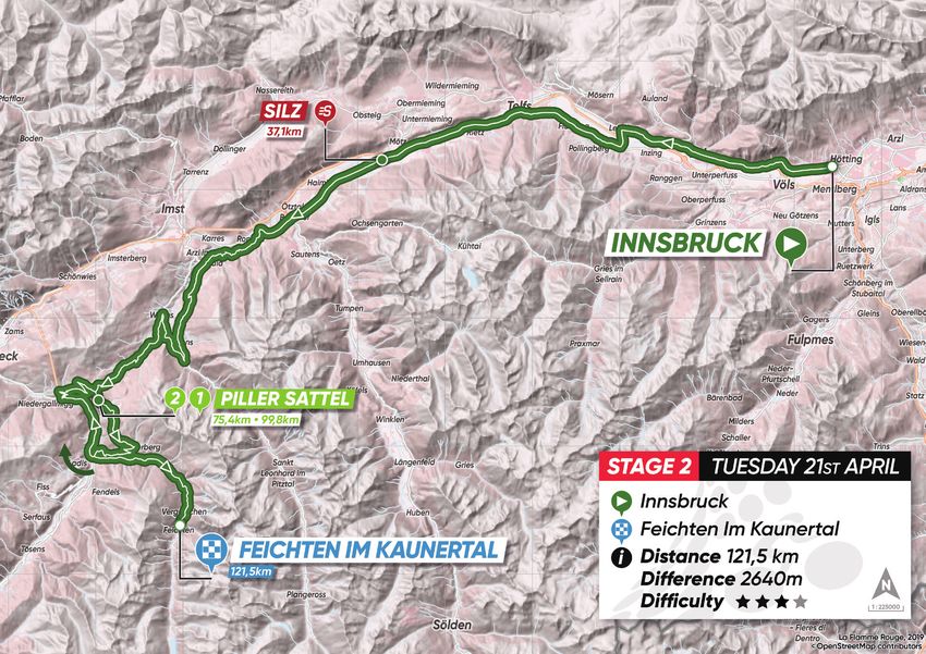
2020
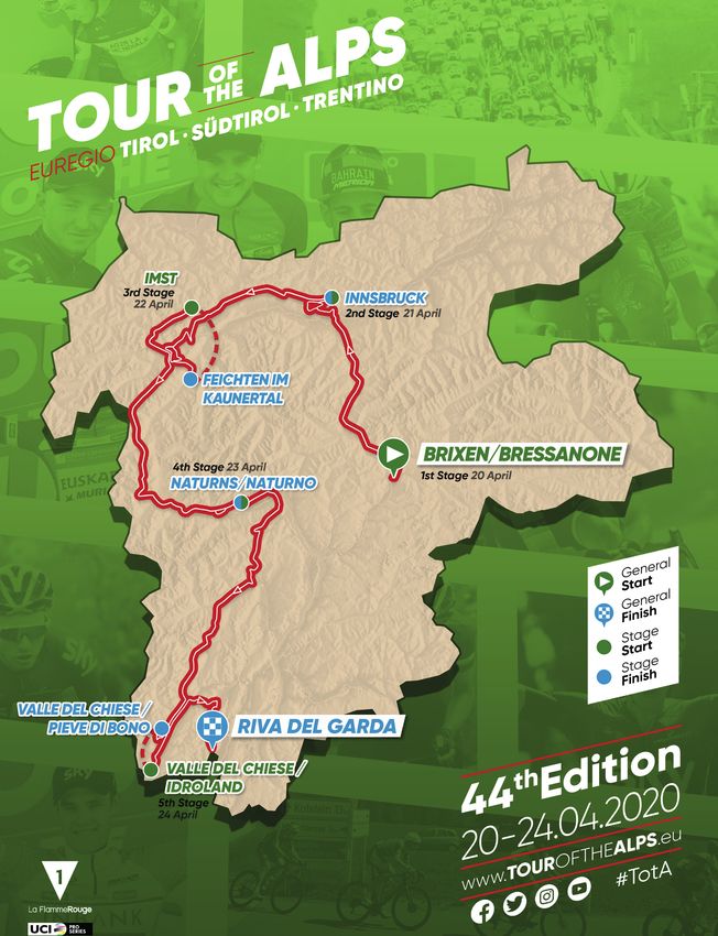
DESCRIPTION / DESCRIZIONE / BESCHREIBUNG 20.– 24.04.2020
TEN
KEI
TER
SCH COLTÀ
HÖ ETRIA
DIF CULTY
RIG
ME
DIS NZA
DIS NCE
ALT UDE
Z
WIE
PPE
TAN
UM
HEN
TAP E
ETA A
IM
TA
TA
A
G
IT
E
P
FI
FI
DAT
DAT
DAT
STA
ALT
DIS
DIF
Monday 20 April
01 Lunedì 20 Aprile Brixen/Bressanone → km 142,8 mt 1.950 ★★★★★
Montag 20 April Innsbruck
Tuesday 21 April
02 Martedì 21 Aprile Innsbruck → Feichten im km 121,5 mt 2.640 ★★★★★
Dienstag 21 April Kaunertal
Wednesday 22 April
03 Mercoledì 22 Aprile Imst → km 163,9 mt 2.290 ★★★★★
Mittwoch 22 April Naturns /Naturno
Thursday 23 April
04 Giovedì 23 Aprile Naturns/Naturno → Valle km 168,6 mt 3.880 ★★★★★
Donnerstag 23 April del Chiese/Pieve di Bono
Friday 24 April Valle del Chiese/Idroland
05 Venerdì 24 Aprile → km 120,9 mt 2.230 ★★★★★
Freitag 24 April Riva del Garda
TotA2020_Route_informations_28ott19.indd 2 25/10/19 16:22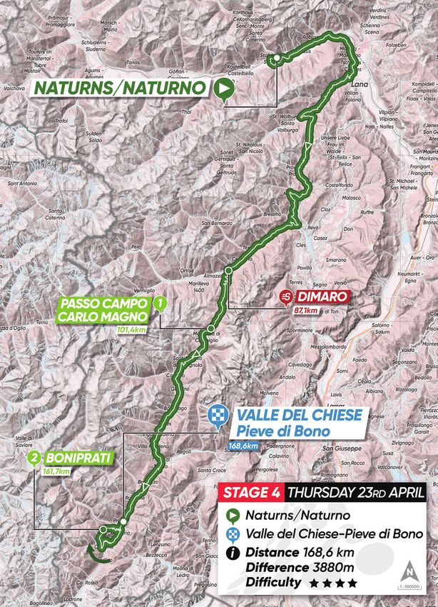
2020
        STAGE 1 / 1a TAPPA / ETAPPE 1
        Monday 20 April / Lunedì 20 Aprile / Montag 20 April

        Brixen/ Bressanone                   →   Innsbruck / km 142,8
        ROUTE / PERCORSO / KARTE
                                                              KOM / G.P.M. /
                                                              BERGWERTUNG:
                                                              Brenner Pass/Passo del Brennero
                                                              (mt. 1371 / km 52 / 2° cat.);
                                                              Axams
                                                              (mt. 887 / km 107 / 3° cat.)

                                                              INTERMEDIATE SPRINT /
                                                              TV / ZWISCHENSPRINT:
                                                              Sterzing/Vipiteno (km 39)

                 PROFILE / ALTIMETRIA / HÖHENDIAGRAMM

TotA2020_Route_informations_28ott19.indd 3                                                      25/10/19 16:22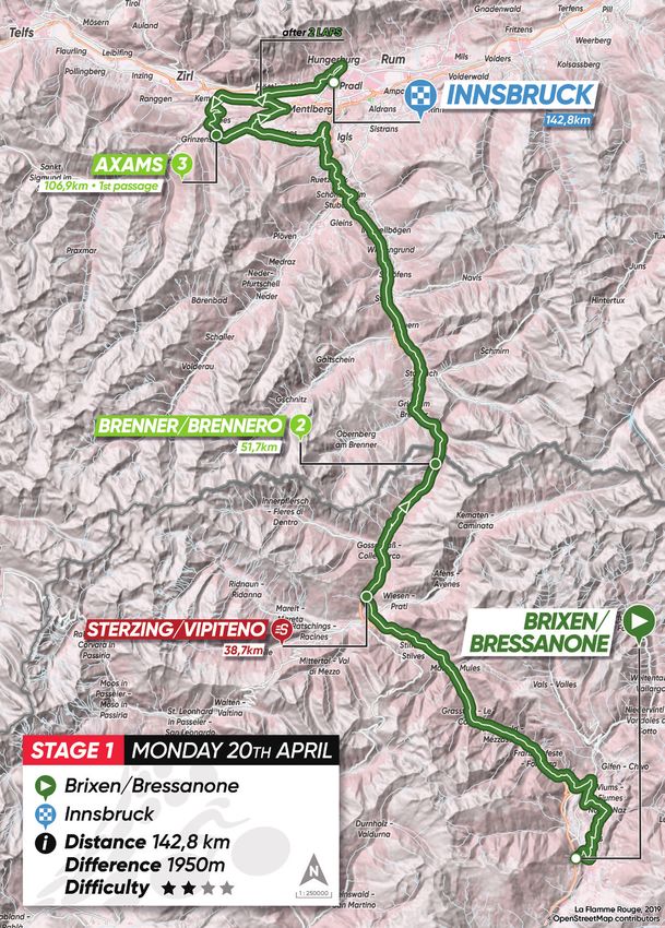
2020
        STAGE 1 / 1a TAPPA / ETAPPE 1
        Monday 20 April / Lunedì 20 Aprile / Montag 20 April

      STAGE 1 DESCRIPTION                      DESCRIZIONE TAPPA 1                     BESCHREIBUNG ETAPPE 1
      The Tour of the Alps 2020 starts off     La prima tappa del Tour of the Alps     Die erste Etappe der Tour of the Alps
      with a climb.                            inizia subito in salita.                2020 geht von Beginn an bergauf.

      The course encloses soft slope which     Sono pendenze lievi che sembrano        Bei den Anstiegen im ersten
      seem designed on purpose for the         disegnate apposta per qualche           Etappenteil handelt es sich um
      bravest long-distance attackers,         coraggioso fuggitivo della prima        kleinere Rampen, die – zumindest
      until the road enters Sterzing/          ora, almeno fino a quando la            bis Sterzing/Vipiteno – zu einem
      Vipiteno. There, after ascending         strada raggiunge Vipiteno. Lì, dopo     prädestinierten Pflaster für Ausreißer
      the Eisack/Isarco valleys, the road      aver risalito dolcemente le vallate     verkommen könnten. Im Wipptal
      climbs firmly towards the turns of the   dell’Isarco, l’ascesa si inerpica più   angekommen, geht es zunächst den
      Brenner Pass/Passo del Brennero,         arcigna lungo i tornanti del Passo      Tälern des Eisacktales entlang, ehe
      where the first categorized climb of     del Brennero, teatro del primo          die anspruchsvollen Serpentinen
      the 2020 Tour of the Alps is placed.     traguardo valido come GPM.              hoch zum Brennerpass warten.
                                                                                       Nachdem an der italienisch-
      After crossing the Italian-Austrian      Valicato il confine di stato italo-     österreichischen Grenze die ersten
      border, a quick dive will lead to the    austriaco, una veloce picchiata         Punkte der GPM-Wertung vergeben
      outskirts of Innsbruck, where riders     condurrà alle porte di Innsbruck,       werden, führt eine schnelle Abfahrt
      will continue the race with two laps     dove i corridori si troveranno ad       vor die Tore Innsbrucks.
      of a wide circuit characterized by the   affrontare un ampio circuito di due
      Axams ascent, the same climb dealt       giri caratterizzato dalla salita di     In der Hauptstadt Nordtirols müssen
      by the riders in the 2019 Innsbruck      Axams, la stessa asperità affrontata    die Fahrer einen Rundkurs über zwei
      World Championships’ time trials.        durante la cronometro a squadre         Runden absolvieren, wobei dort der
                                               dei campionati del mondo di             Aufstieg nach Axams besonders
      The last time atop the hill, located     Innsbruck 2018.                         ins Auge sticht. Dieser war bereits
      with 18km to the finish line, could                                              beim Mannschaftszeitfahren der
      become an excellent springboard.         L’ultimo scollinamento, posto a 18km    Weltmeisterschaft von Innsbruck
                                               dal traguardo, potrebbe rilevarsi un    2018 Teil der Strecke und brachte
                                               ottimo trampolino di lancio.            dort gar einige Teilnehmer an ihre
                                                                                       Grenzen.

                                                                                       Aber auch der letzte Anstieg
                                                                                       18 Kilometer vor Schluss hat es
                                                                                       ordentlich in sich.

TotA2020_Route_informations_28ott19.indd 4                                                                              25/10/19 16:22
2020
        STAGE 2 / 2a TAPPA / ETAPPE 2
        Tuesday 21 April / Martedì 21 Aprile / Dienstag 21 April

        Innsbruck                     →      Feichten im Kaunertal / km 121,5
        KOM / G.P.M. / BERGWERTUNG: Piller Sattel (mt. 1559 / km 75 / 2° cat.);
         Piller Sattel (mt. 1559 / km 100 / 1° cat.)
        INTERMEDIATE SPRINT / TV / ZWISCHENSPRINT: Silz (km 37)
        ROUTE / PERCORSO / KARTE

                 PROFILE / ALTIMETRIA / HÖHENDIAGRAMM

TotA2020_Route_informations_28ott19.indd 5                                         25/10/19 16:22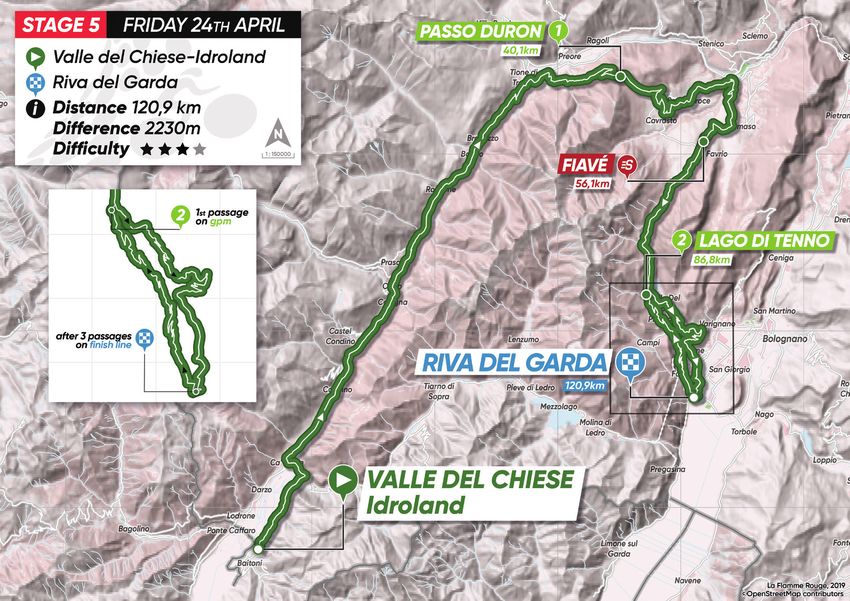
2020
        STAGE 2 / 2a TAPPA / ETAPPE 2
        Tuesday 21 April / Martedì 21 Aprile / Dienstag 21 April

      STAGE 2 DESCRIPTION                         DESCRIZIONE TAPPA 2                        BESCHREIBUNG ETAPPE 2
      2500 meters of altitude, all                2500 metri di dislivello tutti             Bei der zweiten Etappe kann man
      concentrated in the second half of          concentrati nella seconda parte di         getrost von einem „zweigeteilten“
      the stage, as the first 50 kilometers       tappa, preceduti da una cinquantina        Teilstück sprechen: Auf den ersten
      of it are mostly flat, easing up the        di chilometri sostanzialmente              50, meist flachen Kilometern haben
      warmup of the riders.                       pianeggianti e rettilinei che serviranno   die Fahrer die Möglichkeit, ihre Beine
                                                  a rodare le gambe.                         auf Temperatur zu bringen, ehe
      The first ascent of the day will lead                                                  auf dem zweiten Etappenteil nicht
      to Arzl im Pitztal, the village of former   La prima asperità di giornata ci           weniger als 2.500 Höhenmeter zu
      Austrian ski champion Benni Raich.          condurrà ad Arzl im Pitztal, il paese      bewältigen sind.
                                                  del fuoriclasse dello sci Benni Raich.
      After a short descent, the road starts                                                 Das erste unebene Stück führt in
      to climb toward the top of the Piller       Successivamente, dopo una breve            den Heimatort des österreichischen
      Sattel, where the first GPM will be         discesa, si ricomincerà a salire verso     Skistars Benjamin Raich, der
      placed. The second ascent to the            la vetta del Piller Sattel, dove sarà      Ortschaft Arzl im Pitztal. Nach einer
      Piller Sattel, taking in the toughest       posto anche il primo traguardo             kurzen Abfahrt folgt der Anstieg zum
      slope moving up from Fließ, will be         GPM. La seconda ascesa al Piller           Piller Sattel, wo es wichtige Punkte
      the main difficulty of the day.             Sattel, stavolta dal versante più          für die GPM-Wertung zu holen gibt.
                                                  impegnativo che parte da Fließ,
      Just 21 kilometers will be left to the      sarà proprio il piatto forte del giorno.   Danach wartet mit dem zweiten
      finish line as the riders reach the                                                    Anstieg zum Piller Sattel – diesmal
      top of this mountain, evenly split          Una volta scollinati, al traguardo         über die weit anspruchsvollere
      between downhill and uphill.                mancheranno circa 21 chilometri, da        Route ab Fließ – der Höhepunkt der
                                                  spartirsi quasi equamente tra discesa      zweiten Etappe.
      The last 11km will lead to the finish       e salita.
      line in Feichten, with the most                                                        Auf den letzten rund 21 Kilometern
      challenging section coming between          Gli ultimi 11 condurranno al traguardo     geht es abwechselnd bergauf und
      6 and 3 kilometers to go, when the          di Feichten. Il tratto più impegnativo     bergab, wobei der schwierigste
      gradient hits even beyond 12%.              dai -6 ai -3, quando la strada si          Teil sechs bis drei Kilometer vor
                                                  inerpicherà sotto le ruote dei             Schluss ansteht: Die Fahrer müssen
                                                  corridori per pendenze superiori           eine Rampe mit einer maximalen
                                                  anche al 12%.                              Steigung von über zwölf Prozent
                                                                                             hinter sich bringen, ehe sie in
                                                                                             Feichten im Kaunertal die Ziellinie
                                                                                             überqueren.

TotA2020_Route_informations_28ott19.indd 6                                                                                    25/10/19 16:22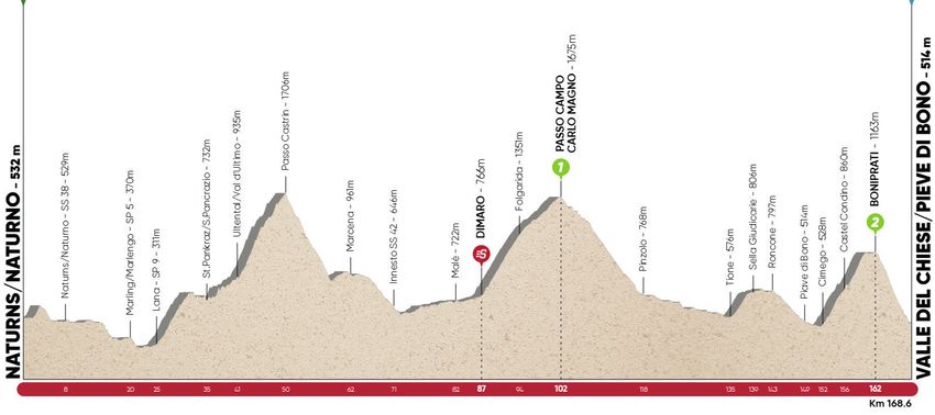
2020
        STAGE 3 / 3a TAPPA / ETAPPE 3
        Wednesday 22 April / Mercoledì 22 Aprile / Mittwoch 22 April

        Imst           →        Naturns /Naturno / km 163,9
        ROUTE / PERCORSO / KARTE
                                                              KOM / G.P.M. /
                                                              BERGWERTUNG:
                                                              Reschen/Resia
                                                              (mt. 1504 / km 76 / 2° cat.);
                                                              Tarsch/Tarres
                                                              (mt. 797 / km 146 / 1 cat.)

                                                              INTERMEDIATE SPRINT /
                                                              TV / ZWISCHENSPRINT:
                                                              Pfunds (km 56)

                 PROFILE / ALTIMETRIA / HÖHENDIAGRAMM

TotA2020_Route_informations_28ott19.indd 7                                                     25/10/19 16:22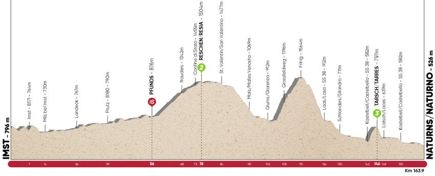
2020
        STAGE 3 / 3a TAPPA / ETAPPE 3
        Wednesday 22 April / Mercoledì 22 Aprile / Mittwoch 22 April

      STAGE 3 DESCRIPTION                       DESCRIZIONE TAPPA 3                       BESCHREIBUNG ETAPPE 3
      A short initial circuit inside Imst       Un breve circuito iniziale all’interno    Die dritte Etappe beginnt mit einer
      introduces the first part of the stage,   di Imst introduce una prima parte         Rundfahrt durch das Stadtinnere
      characterized by wide streets with        di tappa caratterizzata da strade         von Imst, ehe es für das Feld auf
      soft slopes, though the wind could        ampie che salgono dolcemente,             breiten Straßen leicht bergauf in
      also represent a factor.                  dove però il vento potrebbe               Richtung Südtirol geht.
                                                diventare un protagonista.
      The route becomes more difficult                                                    Auf     diesem     Streckenabschnitt
      after 60km, even if the ascent to         Il percorso si fa più esigente dopo       könnte der Wind vielen Fahrern einen
      the first KOM of Reschenpass/Passo        60km, anche se l’ascesa verso             Strich durch die Rechnung machen.
      Resia is not likely to make any major     il primo GPM di Passo Resia è             Nach etwa 60 Kilometern wartet der
      selection: wide, straight roads and       tutt’altro che selettiva: strada larga,   Anstieg zum Reschenpass/Passo
      tunnels. More challenging, even if        qualche galleria e lunghi rettilinei.     di Resia, wo die nächsten Punkte
      not marked by the GPM goal, will be       Più impegnativi, anche se non             für die GPM-Wertung vergeben
      the 10 kilometers of roads climbing       contraddistinti dal traguardo GPM,        werden. Da die Rampe hoch zum
      up the Vinschgau/Val Venosta              saranno i 10 chilometri di stradine       Pass durch einige Tunnel sowie lange
      which will lead the peloton to the        che si inerpicheranno su per la Val       Geraden entlang führt, muss sie
      Frinig area.                              Venosta per portare il gruppo nella       nicht besonders gefürchtet werden.
                                                zona di Frinig.                           Weitaus selektiver, wenngleich nicht
      Back on the main road through a                                                     mit einer GPM-Wertung versehen,
      very technical descent followed by        Rientrati sulla statale attraverso una    sind die zehn Kilometer, die in den
      the climb of Tarsch/Tarres, one of        discesa molto tecnica, resterà da         Vinschgau/Val Venosta Richtung
      the most dreaded.                         superare l’asperità di Tarres.            Frinig führen.

      It is a top and demanding ascent          Un’ascesa breve ed esigente               Nach einer technisch anspruchsvollen
      that will end at 18 kilometers from       posta a 18 chilometri dal traguardo       Abfahrt stehen ein paar ungemütliche
      the finish line in Naturns/Naturno,       di Naturno, che potrebbe                  Kilometer nach Tarsch/Tarres auf
      and this oculd eventually make it         rappresentare il terreno ideale per       dem Programm, ehe es 18 Kilometer
      an ideal springboard for any solo or      un colpo di mano solitario o per          vor der Ziellinie in Naturns/Naturno
      team action.                              un’azione di squadra.                     zum letzten Mal bergauf geht.

                                                                                          Diese abschließende Rampe scheint
                                                                                          wie gemacht für den Coup eines
                                                                                          Ausreißers oder eine taktische
                                                                                          Meisterleistung einer ganzen
                                                                                          Mannschaft zu sein.

TotA2020_Route_informations_28ott19.indd 8                                                                               25/10/19 16:22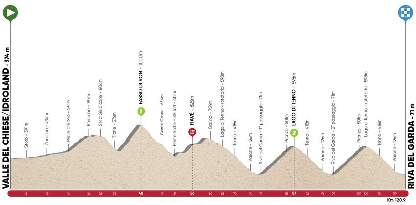
2020
        STAGE 4 / 4a TAPPA / ETAPPE 4
        Thursday 23 April / Giovedì 23 Aprile / Donnerstag 23 April

        Naturns/Naturno                      →   Valle del Chiese/Pieve di Bono / km 168,6
        ROUTE / PERCORSO / KARTE
                                                                 KOM / G.P.M. /
                                                                 BERGWERTUNG:
                                                                 Passo Campo Carlo Magno
                                                                 (mt. 1675 / km 102 / 1° cat.);
                                                                 Boniprati
                                                                 (mt. 1163 / km 162 / 2° cat.)

                                                                 INTERMEDIATE SPRINT /
                                                                 TV / ZWISCHENSPRINT:
                                                                 Dimaro (km 87)

                 PROFILE / ALTIMETRIA / HÖHENDIAGRAMM

TotA2020_Route_informations_28ott19.indd 9                                                         25/10/19 16:22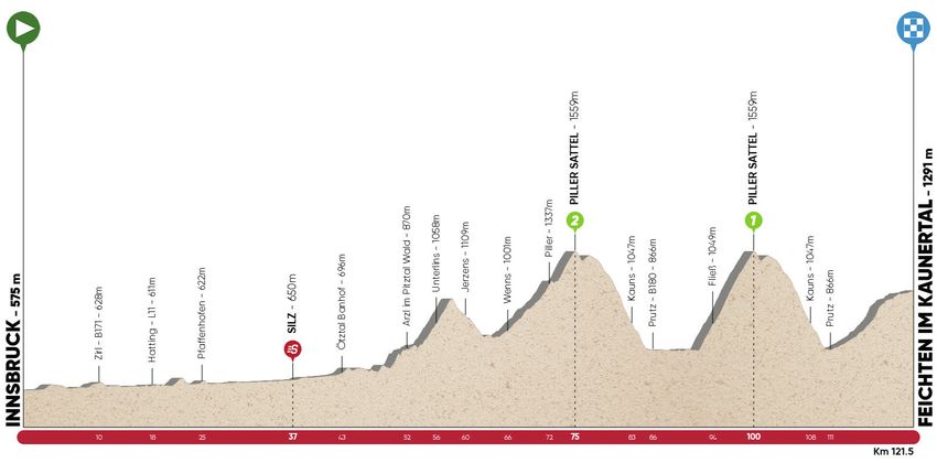
2020
        STAGE 4 / 4a TAPPA / ETAPPE 4
        Thursday 23 April / Giovedì 23 Aprile / Donnerstag 23 April

      STAGE 4 DESCRIPTION                       DESCRIZIONE TAPPA 4                       BESCHREIBUNG ETAPPE 4
      The longest stage also presents           La tappa più lunga è anche                Die vierte Etappe ist nicht nur das
      the greatest overall elevation gain;      quella con il dislivello complessivo      längste Teilstück der Tour of the Alps
      for this reason the fourth stage can      maggiore; per questo la quarta            2020, sondern auch jenes mit dem
      rightly be defined a key stage.           frazione potrebbe prestarsi a dei         größten Höhenunterschied.
                                                rivolgimenti in classifica generale.
      The circuit leading out of Naturns/                                                 Deshalb ist es durchaus möglich,
      Naturno starts with a straight uphill,    Il circuito che porta fuori Naturno       dass es auf dieser Etappe zu
      the first KOM of the day is located       è subito in salita e il primo GPM         einer Vorentscheidung in Hinblick
      slightly later, when the group will be    di giornata arriva poco più tardi,        auf die Gesamtwertung kommt.
      crossing the 1706-meters-long Passo       quando il gruppo si troverà a valicare    Auch wenn die ersten Punkte
      Castrin tunnel, the highest spot of       i 1706 del tunnel di Passo Castrin,       für die GPM-Wertung erst am
      the 2020 Tour of the Alps. The long       tetto del Tour of the Alps 2020. La       Hofmahdjoch/Passo Castrin zu
      descent will carry the riders to Val di   lunga discesa ci porterà nella Val        holen sind, kommen die Fahrer
      Non, leaning towards Dimaro. After        di Non in direzione Dimaro, per poi       vom Start in Naturns weg sofort
      the flat-out downhill, the road will      risalire con decisione verso Passo        ins Schwitzen. Durch den Passo-
      begin to rise again towards Passo         Campo Carlo Magno: 1000 metri di          Castrin-Tunnel, dem höchsten Punkt
      Campo Carlo Magno: almost 1000            dislivello in quasi 14 km. L’asperità     der Rundfahrt, geht es das Nonstal/
      meters gain allocated over 14 km.         successiva si incontrerà nei pressi di    Valle di Non hinab nach Dimaro, ehe
      The following climb will be the Selle     Tione e si tratta dello strappo non       der selektive Anstieg in Richtung
      Giudicarie, near Tione.                   banale di Selle Giudicarie.               Kaiser Karl der Große Pass/Passo
                                                                                          Campo Carlo Magno, eine knapp
      However, the strongest athletes           Probabile, però, che gli uomini di        14 Kilometer lange Rampe über
      will probably decide to play the          classifica decidano di giocarsi le loro   rund 1.000 Höhenmeter, wartet. Zeit
      deciding card on the brand-new            carte affrontando l’inedita salita        zum Verschnaufen gibt es für das
      ascent of Castel Condino towards          di Castel Condino verso Boniprati.        Feld kaum – direkt im Anschluss
      Boniprati: 10 km of vertical ascent       10 km di strada verticale che si          steht nämlich der Anstieg von der
      ending 7km far from the Pieve di          concludono a 7km dal traguardo di         Ortschaft Tione hin zur Gemeinde
      Bono finish line.                         Pieve di Bono.                            Sella Giudicarie auf dem Programm.

                                                                                          Im Etappenfinish sticht schließlich
                                                                                          die zehn Kilometer lange Rampe
                                                                                          von Castel Condino nach Boniprati
                                                                                          besonders hervor – spätestens
                                                                                          dieser Anstieg wird die Spreu dann
                                                                                          endgültig vom Weizen trennen.

TotA2020_Route_informations_28ott19.indd 10                                                                                25/10/19 16:22
2020
STAGE 5 / 5a TAPPA / ETAPPE 5
Friday 24 April / Venerdì 24 Aprile / Freitag 24 April
Valle del Chiese/Idroland → Riva del Garda / km 120,9
KOM / G.P.M. / BERGWERTUNG: Passo di Duron (mt. 1000 / km 40 / 1° cat.);
Lago di Tenno (mt. 598, km 87 / 2° cat.)
INTERMEDIATE SPRINT / TV / ZWISCHENSPRINT: Fiavè (km 56)
ROUTE / PERCORSO / KARTE
PROFILE / ALTIMETRIA / HÖHENDIAGRAMM
TotA2020_Route_informations_28ott19.indd 11 25/10/19 16:222020
STAGE 5 / 5a TAPPA / ETAPPE 5
Friday 24 April / Venerdì 24 Aprile / Freitag 24 April
STAGE 5 DESCRIPTION DESCRIZIONE TAPPA 5 BESCHREIBUNG ETAPPE 5
Despite the limited mileage, the Nonostante il chilometraggio limitato, Auch wenn die letzte Etappe nicht
route of the last stage could bring il percorso dell’ultima tappa potrebbe besonders lang ist, so bietet sie
some surprising attacks. prestarsi ad alcuni attacchi a dennoch das ideale Terrain für
sorpresa. einige Überraschungsangriffe.
In fact, apart from the first 20 km,
completely flat, the remaining Se si escludono i primi 20 km Lässt man die ersten 20, völlig
distance of the stage is studded completamente pianeggianti, infatti, flachen Startkilometer außen vor,
with climbs of different length il resto della frazione è costellato so bleibt den Fahrern bei vielen
and gradient. The first hill will be da salite e strappi di varia natura Rhythmuswechseln kaum Zeit
the panoramic ascent of Selle e difficoltà. La prima asperità zum Verschnaufen. Zum ersten
Giudicarie. After the climb, before sarà l’ascesa panoramica di Selle Mal bergauf geht es nach Sella
reaching the final circuit of Riva Giudicarie. Ad essa, prima di entrare Giudicarie, ehe weitere Rampen
del Garda, the riders be facing the nel circuito finale di Riva del Garda, zum Passo Duron (6,4 Kilometer
ascents to Passo Duron (6.4 km to si aggiungeranno la salita di Passo lang mit einer maximalen Steigung
7.9%) and Valico del Ballino. Duron (6,4 km al 7,9%) e il Valico von 7,9 Prozent) und dem Passo del
del Ballino. Ballino warten.
From there we will move towards the
Tenno Lake to reach Riva’s finish line Da lì ci si dirigerà verso il Lago di Von Ballino aus geht es weiter in
for the first time. Tenno per raggiungere il traguardo Richtung Tennosee/Lago di Tenno,
di Riva per la prima volta. wo zum ersten Mal der TotA-Zielort
At this point only 40 kilometers will Riva del Garda anvisiert wird.
be remaining in the 2020 Tour of A quel punto ci troveremo di fronte
the Alps: two laps of the final circuit gli ultimi 40 chilometri del Tour of the Auf den letzten 40 Kilometern
including the Pranzo climb. Alps 2020. Un circuito di due giri che der Tour of the Alps 2020 müssen
sarà caratterizzato dalla salita di zwei Runden absolviert werden,
From the last time atop, only 12 km Pranzo (8,5 km al 6%). bei denen der 8,5 Kilometer lange
will be missing to the finish in Via Anstieg zur Ortschaft Pranzo
San Francesco, most of which to be Dall’ultimo scollinamento mancheranno (maximale Steigung: 6 Prozent)
covered on a fast descent. solamente 12 km al traguardo di besonders hervorsticht.
Via San Francesco, la maggior parte
dei quali in veloce discesa. Die zwölf Schlusskilometer verlaufen
mehrheitlich bergab und enden in
der Via San Francesco – dort darf
sich dann ein neues Siegergesicht
über den Gewinn der prestigereichen
Rundfahrt freuen.
TotA2020_Route_informations_28ott19.indd 12 25/10/19 16:22Sie können auch lesen