Wandernadel Pass Hiking Pin Pass
←
→
Transkription von Seiteninhalten
Wenn Ihr Browser die Seite nicht korrekt rendert, bitte, lesen Sie den Inhalt der Seite unten
Wandernadel Pass
Hiking Pin Pass
Region St. Johann in Tirol: kitzalps.cc
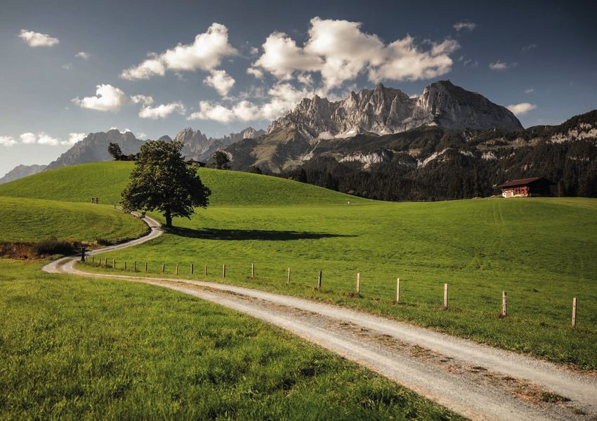
Lieber Wanderer,                                                                Dear hikers,
Ein Glücksmoment hat viele Ausdrucksformen: ein Durchatmen, ein                 Moments of happiness come in all shapes and sizes: a deep and slow
Lächeln, ein Flow-Gefühl, eine Neuronen-Explosion im Mittelhirn ... in          breath, a friendly smile, feeling the flow, a neuron explosion in the
jedem Fall ist es sehr angenehm. Einer der größten Glücksauslöser heißt         midbrain … in any case, they feel good and are absolutely crucial to our
„Urlaub“ – jene Zeit, in der die Menschen zu sich finden, das Leben zu          wellbeing. One of the most common “happiness triggers” is vacation: it
genießen versuchen, Neues entdecken wollen oder zum Beliebten                   is the time away from daily life, the time to reconnect and to enjoy new
zurückkehren.                                                                   sights or revisit old favorites.

Als Tourismusort haben wir uns diesen Wünschen verpflichtet. Unsere Re-         We take your vacation seriously. St. Johann in Tirol region has four towns
gion St. Johann in Tirol hat 4 Orte und viele Talente, um Sie auf vielfältige   and countless opportunities to make you feel happy. And whatever it is
Weise zu erfreuen. Am Ende soll Ihr persönliches Glück stehen. Was immer        that makes you happy here, we have a word for it:
Sie aber hier bei uns happy macht, wir haben ein Wort dafür:                    #myYapadu
#meinYapadu
                                      2                                                                               3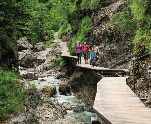
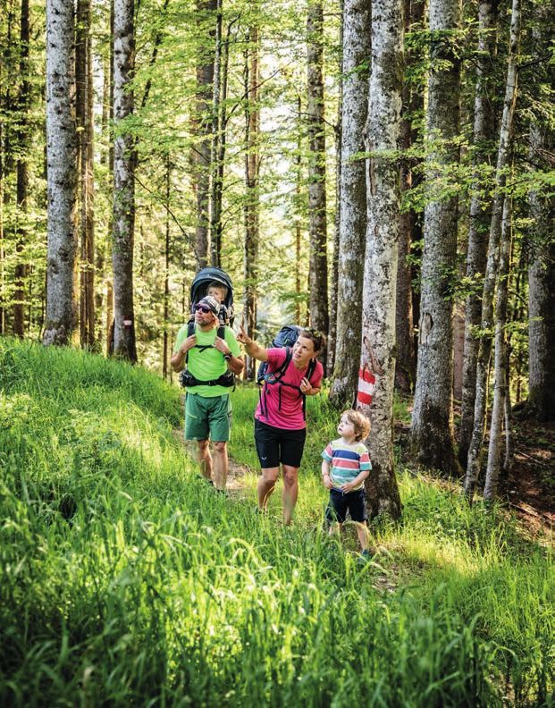
SummitLynx                   Digitale
Das digitale Tourenbuch
  The digital tour book      Wandernadel
                             Mit der App SummitLynx können alle Bergfreunde
                             Wandernadeln innerhalb unserer Region mit ihrem GPS-fähigen
                             Handy sammeln und diese Erfolge zusätzlich auch auf Facebook teilen.
                             Die App ist GRATIS und bietet zudem das traditionelle Gipfelbuch in
                             digitaler Form an.

                             Digital Hiking Pin
                             The SummitLynx app allows you to collect digital hiking pins with your
                             smartphone, and share them with your friends on Facebook. The free app
                             also includes a digital summit log with a proof of location concept that
                             utilizes the GPS chip in your phone.

                             Alle Infos und Download auf:
                             For more information visit:
                             www.kitzalps.cc/wanderapp

 www.kitzalps.cc/wanderapp
            4                                                       5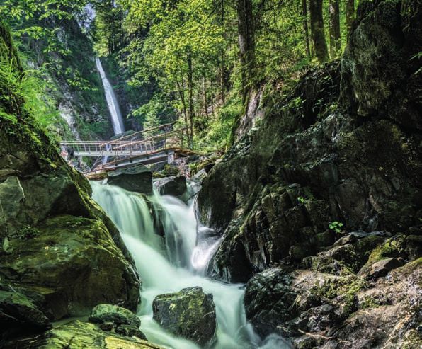
Wanderabzeichen
                      Hiking Pin
            So erhalten Sie Ihr Wanderabzeichen:
                    How to get your hiking pin:

      300                      400                      150
                                                                              Grießbachklamm
    Punkte/Points            Punkte/Points            Punkte/Points

  Silber/Silver                 Gold                   Bronze
                                                                      1

Mit gestempeltem Wanderpass erhalten Sie mit Ihrer Gästekarte                 Stempelstelle im Ruhebereich neben dem Wanderweg
in den Infobüros St. Johann in Tirol, Oberndorf oder Kirchdorf Ihr            Ausgangspunkt: Parkplatz Grießbachklamm in Erpfendorf
                    kostenloses Wanderabzeichen.                              Schwierigkeit: mittelschwieriger Bergweg
  Bring your stamped hiking pass and guest card to our tourist
                                                                       25
                                                                      Pu
                                                                       nkte

 offices in St. Johann in Tirol, Oberndorf or Kirchdorf to collect            Stamp pad in the rest area beside the hiking trail
                        your free hiking pin.                                 Starting Point: parking place Grießbachklamm in Erpfendorf
              = kindertauglicher Wanderweg / child-friendly hike              Difficulty: moderately difficult mountain trail

                                  6                                                                         7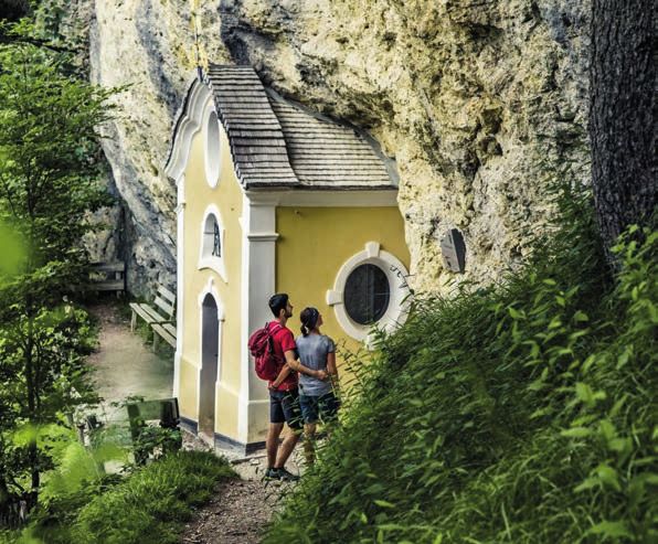
2       Gmailkapelle                                        3       Schmiedkreuz
        Höhe 965 m, Stempelstelle neben der Kapelle                 Höhe 750 m, Stempelstelle am Kreuz
        Ausgangspunkt: Rummlerhof in St. Johann in Tirol            Ausgangspunkt: Clemens-Holzmeister-Kirche Erpfendorf
        Schwierigkeit: mittelschwieriger Bergweg                    Schwierigkeit: leichter Bergweg
 25                                                          25
                                                            Pu
Pu
 nkte                                                        nkte

        Altitude 965m; stamp pad next to the chapel                 Altitude 750m; stamp pad on the cross
        Starting Point: Rummlerhof in St. Johann in Tirol           Starting Point: Parish church Erpfendorf
        Difficulty: moderately difficult mountain trail             Difficulty: easy mountain trail

                                     8                                                           9
4       Eifersbacher Wasserfall                           5       Schlosserbergsee
        Am Steg zum Wasserfall                                    Höhe 1100 m, Stempelstelle beim Stein am See
        Ausgangspunkt: Zentrum in St. Johann in Tirol             Ausgangspunkt: Harschbichlbahn in St. Johann in Tirol
        Schwierigkeit: mittelschwieriger Bergweg                  Schwierigkeit: mittelschwieriger Bergweg
 25                                                        25
                                                          Pu
Pu
 nkte                                                      nkte

        Stamp pad at the bridge before the waterfall              Altitude 1100m; stamp pad at the rock by the lake
        Starting Point: center of St. Johann in Tirol             Starting Point: Harschbichlbahn in St. Johann in Tirol
        Difficulty: moderately difficult mountain trail           Difficulty: moderately difficult mountain trail

                                    10                                                         11
6       Penzing                                           7       Grutten
        Höhe 1550 m, Stempelstelle am Kreuz                       Höhe 900 m, Stempelstelle beim Wegweiser
        Ausgangspunkt: Wiesenschwang in Oberndorf                 Ausgangspunkt: Informationsbüro Oberndorf
        Schwierigkeit: mittelschwieriger Bergweg                  Schwierigkeit: leichter Bergweg
 25                                                        25
                                                          Pu
Pu
 nkte                                                      nkte

        Altitude 1550m; stamp pad on the cross                    Altitude 900m; stamp pad at the trail sign
        Starting Point: Wiesenschwang in Oberndorf                Starting Point: Oberndorf Tourist Office
        Difficulty: moderately difficult mountain trail           Difficulty: easy mountain trail

                                    12                                                        13
14
Etappe 1
                                                                                Start: St. Johann in Tirol, Infobüro -         1.060 m   1.265 m
                                                                                Einsiedelei Maria Blut - Gmailkapelle -
                                                                                Schatterkopf - Bacheralm
                                                                                                                               19 km       7h
                                                                                Ziel: Kirchdorf, Griesner Alm

                                                                                Etappe 2
                                                                                Start: Kirchdorf, Griesner Alm - Stripsen-
                                                                                                                               1.150 m   1.810 m
                                                                                jochhaus - Tavonarokreuz - Stripsenkopf
                                                                                - Feldberg - Fischbachalm
                                                                                                                               12 km      7,5 h
                                                                                Ziel: Kirchdorf, Griesner Alm
„Du bist die Krone über einem begnadet schönen Fleck Tiroler Erde“, mit
diesen Worten hat Fritz Schmitt den Koasa, in seinem Buch „Das Buch vom         Etappe 3
Wilden Kaiser“ einst beschrieben. Dieser Krone – dem Koasa - ist dieser         Start: Kirchdorf, Griesner Alm - Stuben-
                                                                                                                               710 m     1.255 m
Weitwanderweg gewidmet. Die einzelnen Touren wurden so angelegt, dass           alm - Sprissleralm - Teufelsgasse - Teufels-
jede Route durch einen besonderen Naturschauplatz unserer Region führt.         kanzel - Flugwacht/Prostkogel
                                                                                                                               21 km      7,5 h
Jeden Tag erwartet Sie ein Highlight, ob es der Niederkaiserkamm, das           Ziel: Erpfendorf, Vital-Hotel Berghof
malerische Kaiserbachtal, die mystische Teufelsgasse, die bekannte
Grießbachklamm oder der Eifersbacher Wasserfall ist.                            Etappe 4
                                                                                Start: Erpfendorf, Vital-Hotel Berghof -
                                                                                                                               900 m     1.500 m
‘You are the crown above an exceptionally beautiful nook in Tirol’, it was      Grießbachklamm - Angerlalm - Obingalm
with these words that Fritz Schmitt once described the Koasa. This long         - Bruggwirtsalm - Baumooskogl
                                                                                                                               20 km      7,5 h
distance hiking trail is dedicated to this ‘crown’ – the Koasa. Individual      Ziel: St. Johann in Tirol, Hotel Kaiserfels
tours have been set up in such as way that each route proceeds through a
special natural site in our region. A highlight awaits you every day, whether   Etappe 5
it is the Niederkaiser ridge, the picturesque Kaiserbach valley, the mysteri-   Start: St. Johann in Tirol, Hotel Kaiserfels
                                                                                                                               970 m     1.570 m
ous Teufelsgasse, the Grießbachklamm gorge or the Eifersbacher waterfall.       - Eifersbacher Wasserfall - Harschbichl-
                                                                                alm - Stanglalm
            Höhenmeter/Altitude                 Streckenlänge/track length                                                     14 km       7h
            Höchster Punkt/highest point        Dauer/Duration                  Ziel: Oberndorf, Hotel Penzinghof
                                           16                                                                        17
8       Huberhöhe Erpfendorf                                          9       Baumooskogel
        Höhe 1146 m, Stempelstelle am Kreuz                                   Stempelstelle im Ruhebereich neben dem Wanderweg
                                                                     50
        Ausgangspunkt: Parkplatz Grießbachklamm in Erpfendorf        Punkte   Ausgangspunkt: Parkplatz Haberberg in Kirchdorf
        Schwierigkeit: mittelschwieriger Bergweg                              Schwierigkeit: mittelschwieriger Bergweg
 50
Pu
 nkte
        Altitude 1146m; stamp pad on the cross                                Stamp pad in the rest area beside the hiking trail
        Starting Point: parking place Grießbachklamm in Erpfendorf            Starting Point: parking place Haberberg in Kirchdorf
        Difficulty: moderately difficult mountain trail                       Difficulty: moderately difficult mountain trail

                                    18                                                                     19
10 Prostkogel 11 Tavonarokreuz
Höhe 1244 m, Stempelstelle am Kreuz Höhe 1580 m, Stempelstelle am Tavonarokreuz
50
Ausgangspunkt: Parkplatz Hinterberg in Kirchdorf/Gasteig Punkte
Ausgangspunkt: Parkplatz Kaiserbachtal oder
Schwierigkeit: mittelschwieriger Bergweg Parkplatz Griesner Alm in Kirchdorf
50
Pu Schwierigkeit: mittelschwieriger Bergweg
nkte
Altitude 1244m; stamp pad on the cross Altitude 1580m; stamp pad on the cross
Starting Point: parking place Hinterberg in Kirchdorf/Gasteig Starting Point: parking place Kaiserbachtal or
Difficulty: moderately difficult mountain trail parking place Griesner Alm in Kirchdorf
Difficulty: moderately difficult mountain trail
20 2112 Niederkaiserkamm 13 Horn-Gipfel-Höhenweg
50 Höhe 1200 m, Stempelstelle beim Kreuz Ursulablick 50
Punkte
Höchster Punkt 1996 m, Stempelstelle entlang vom Ludwig
Punkte
Ausgangspunkt: Kramerhof in Kirchdorf/Gasteig oder Scheiber Steig
Rummlerhof in St. Johann in Tirol Ausgangspunkt: Bergstation Harschbichlbahn in
Schwierigkeit: mittelschwieriger Bergweg St. Johann in Tirol
Altitude 1200m; stamp near the cross Ursulablick Schwierigkeit: mittelschwieriger Bergweg
Starting Point: Kramerhof in Kirchdorf/Gasteig Highest Point 1996m; stamp pad on Ludwig-Scheiber Trail
Rummlerhof in St. Johann in Tirol Starting Point: gondola station Harschbichl in St. Johann in Tirol
Difficulty: moderately difficult mountain trail Difficulty: moderately difficult mountain trail
22 2314 Fritz-Pflaum-Hütte 15 Maukspitze
Höhe 1866 m, Stempelstelle an der Hütte 100 Höhe 2231 m, Stempelstelle am Gipfelkreuz
100 Punkte
Punkte Ausgangspunkt: Parkplatz Kaiserbachtal oder Ausgangspunkt: Kramerhof in Kirchdorf/Gasteig oder
Parkplatz Griesner Alm in Kirchdorf Rummlerhof in St. Johann in Tirol
Schwierigkeit: mittelschwieriger Bergweg Schwierigkeit: Hochalpine Tour – schwierig
Altitude 1866m; stamp pad at the hut Altitude 2231m; stamp pad on the cross
Starting Point: parking place Kaiserbachtal or Starting Point: Kramerhof in Kirchdorf/Gasteig or
parking place Griesner Alm in Kirchdorf Rummlerhof in St. Johann in Tirol
Difficulty: moderately difficult mountain trail Difficulty: difficult; high alpine hike
24 25Österreichs Almen 1 Kontakt zum Weide-
vieh vermeiden, Tiere
nicht füttern, siche-
ren Abstand halten!
Mind the Cows Avoid contact with
grazing animals. Do
10 WICHTIGE VERHALTENSREGELN not feed the animals,
maintain a safe
10 IMPORTANT HIKING RULES distance at all times!
2 Ruhig verhalten,
Weidevieh nicht er-
schrecken!
Try not to be loud.
Do not startle cattle!
3 Mutterkühe beschüt-
zen ihre Kälber. Be-
gegnung von Mutter-
kühen und Hunden
vermeiden!
Mother cows protect
their calves. Avoid
cows with calves,
especially if you have
a dog with you!
4 Hunde immer unter
Kontrolle und an der
kurzen Leine führen.
Ist ein Angriff abzuse-
hen: Sofort ableinen!
Always keep dogs un-
der control and on a
short leash. If a cow
is going to attack: Let
your dog off the lead!
www.sichere-almen.at
26 275 Wanderwege auf Al-
men und Weiden 9
Zäune sind zu beach-
ten! Falls es ein Tor
nicht verlassen! gibt, dieses nutzen,
danach wieder gut
Do not stray from the schließen und Weide
path! zügig queren!
Respect fences! If
there is a gate, please
use it and close it af-
terwards, then cross
the meadow swiftly!
6 Wenn Weidevieh den
Weg versperrt, mit 10 Begegnen Sie den hier
möglichst großem
Abstand umgehen!
arbeitenden Menschen,
If cattle block your
path give them the der Natur und den
widest berth you can!
Tieren mit Respekt!
7 Bei Herannahen von
Weidevieh: Ruhig Treat the people who
bleiben, nicht den Rü-
cken zukehren, den
Tieren ausweichen!
work here, the countryside
If a cow approaches
and the animals
you: Stay calm, don’t
turn your back on the
with respect!
animal and give it a
wide berth!
8 Schon bei ersten An-
zeichen von Unruhe
Danke
der Tiere Weidefläche
zügig verlassen!
At the first sign of the
Thanks
animals seeming un-
settled, remain calm
and leave the area
quickly!
28 29Stempel/Stamp Stempel/Stamp Stempel/Stamp Stempel/Stamp Stempel/Stamp Stempel/Stamp Stempel/Stamp Stempel/Stamp
Eifersbacher Huberhöhe
Grießbachklamm Gmailkapelle Schmiedkreuz Schlosserbergsee Penzing Grutten
Wasserfall Erpfendorf
25 25 25 25 25 25 25 50
1 Punkte 2 Punkte 3 Punkte 4 Punkte 5 Punkte 6 Punkte 7 Punkte 8 Punkte
Stempel/Stamp
Baumooskogel
9
50
Punkte
Stempel/Stamp Stempel/Stamp Stempel/Stamp Stempel/Stamp Stempel/Stamp Stempel/Stamp Summe/
Total
Horn-Gipfel- Fritz-Pflaum-
Gold
Prostkogel Tavonarokreuz Niederkaiserkamm Maukspitze
Höhenweg Hütte
Silber/Silver
50 50 50 50 100 100 Bronze
10 Punkte 11 Punkte 12 Punkte 13 Punkte 14 Punkte 15 PunkteHerausgeber: Region St. Johann in Tirol 6380 St. Johann in Tirol, Poststraße 2 www. kitzalps.cc Fotos: Franz Gerdl, Sportalpen, Daniel Gollner, Andreas Unterberger, Thomas Plattner, Mirja Geh, Erwin Haiden Martina Foidl, Gernot Riedel
Sie können auch lesen