BOTTENHORN Manual EDGT - Bahrometrix
←
→
Transkription von Seiteninhalten
Wenn Ihr Browser die Seite nicht korrekt rendert, bitte, lesen Sie den Inhalt der Seite unten
EDGTBOTTENHORNP3D

                             Manual
                                english/deutsch

_______________________________________ 1 _____________________________________
                               © 2020 Bahrometrix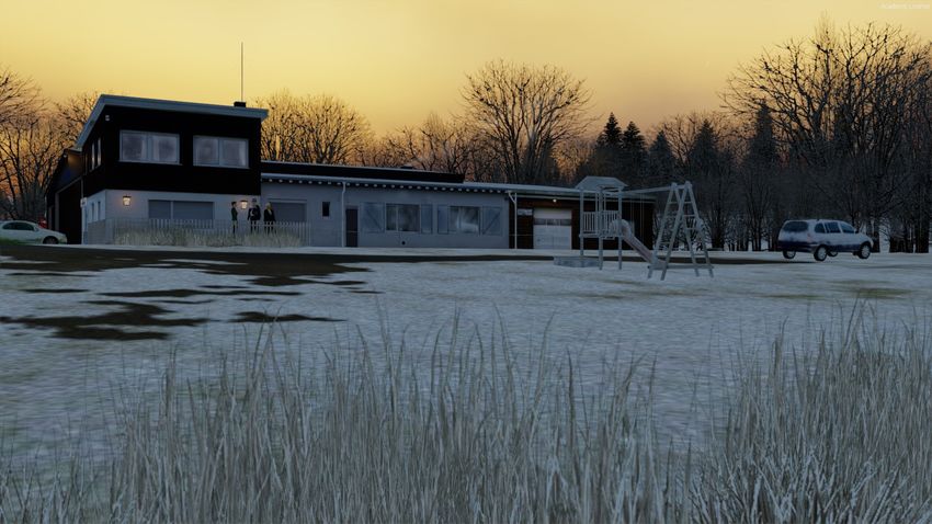
EDGT   BOTTENHORNP3D

Inhalt
Vorwort                                  3

Installation                             4

Scenery Configurator LITE                5

Dynamische Windobjekte                   6

Avatar Gerhard                           7

Technische Informationen                 8

Sonderlandeplatz EDGT Bottenhorn         9

Ortschaft Bottenhorn                     10

Danksagungen / Mitwirkende               11

Lizenzvereinbarung                       11

 _______________________________________ 2 _____________________________________
                                © 2020 Bahrometrix
EDGT   BOTTENHORNP3D

Vorwort

Vielen Dank, dass Sie sich für den Flugplatz EDGT Bottenhorn entschieden haben.

Dies ist der nächste Flugplatz aus der Reihe "Soar-Series". Der Schwerpunkt dieser Reihe
liegt auf Segelflug.- und Sonderlandeplätze. Diese Flugplätze zeichen sich dadurch aus,
dass sie neben einer Graspiste auch ein natürliches Gefälle haben können. Auf den
Plätzen der "Soar Series" können neben Segelflugzeuge auch Ultra-Light's, Motorsegler,
Schleppflugzeuge, Gyrokopter, Hubschrauber, Para-Glider und Ballonflug erlaubt sein.

Somit richtet sich das Szenerie-Angebot an die VFR-Fliegerei.

Durch die Kombination des Orthophotos mit den Geodaten von OpenStreetMap, ergibt
sich daraus eine attraktive Orthoszenerie mit akkuratem und dicht gesetzten Autogen.
Gerade für die Freunde der VFR Fliegerei liegt hier ein großer Reiz, es steht dem
nächsten Abstecher in diese Gegend also nichts mehr im Wege.

Viel Spaß mit EDGT Bottenhorn
Bahrometrix Team

 _______________________________________ 3 _____________________________________
                                © 2020 Bahrometrix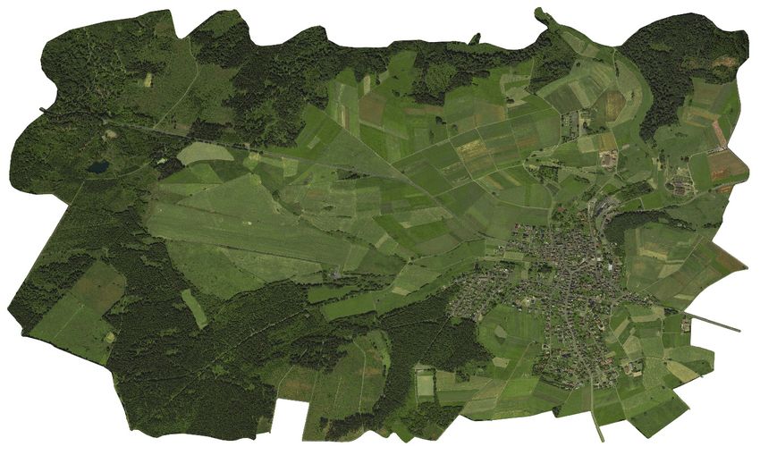
EDGT   BOTTENHORNP3D

Installation
Noch vor der eigentlichen Installation müssen in FTX Germany South drei Dateien
deaktiviert werden:

...\ORBX\FTX_EU\FTX_EU_GES_05_SCENERY\scenery

- ADE_FTX_GES_EDGT.bgl
- ADE_FTX_GES_EDGT_CVX.bgl
- FTX_GES_EDGT_objects.bgl

Hinweis
Wer FTX Germany South nicht installiert hat, kann diesen Schritt zum Deaktivierung der
BGL-Dateien überspringen und mit der eigentlichen Installation fortfahren.

Die Datei P3DV5_Bahrometrix_EDGT_Bottenhorn_V111.exe ausführen und den
Installationsanweisungen folgen. Während der Installation kann man den Installationsort
frei wählen - man muss die Szenerie also nicht in den P3Dv4 hinein installieren. Zum
Abschluss der Installation wird EDGT Bottenhorn automatisch als Add-On Package im
Flugsimulator angemeldet.

Deinstallation:
Die Deinstallation kann über die Verknüpfung im Windows Startmenü oder über die
Systemsteuerung\Programme durchgeführt werden. Bitte vergessen Sie danach nicht die
drei ORBX Dateien wieder zu aktivieren.

 _______________________________________ 4 _____________________________________
                                © 2020 Bahrometrix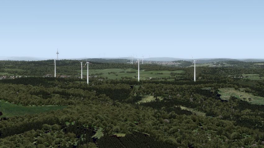
EDGT   BOTTENHORNP3D

Scenery Configurator LITE
Am Ende der Installation von Bottenhorn wird der Configurator ausgeführt. Mit ihm lassen
sich die verschiedenen Szeneriebestandteile komfortabel auf die individuellen Bedürfnisse
des Nutzers anpassen. Ein Speichern der Änderungen ist nicht notwendig, sie werden
direkt beim setzen der Option übernommen. Beenden können Sie den Konfigurator durch
einen Klick auf Schließen (X).

Der Scenery Configurator LITE stammt aus dem Hause 29Palms Scenery Design und wird
Freeware Entwicklern kostenlos zur Verfügung gestellt.

Kompatibilität
Die Kompatibilität/Anbindung zu folgenden Erweiterungen ist gegeben:
VFR Germany 2010, FTX GES, FTX Global/Vector, OpenLC, UTX, GEX

 _______________________________________ 5 _____________________________________
                                © 2020 Bahrometrix
EDGT   BOTTENHORNP3D

Dynamische Windobjekte
Der Flugsimulator Prepar3D stellt von Haus aus keine detaillierte und dynamische
Windobjekte wie Windenergieanlagen und Windfahnen zur Verfügung, daher müssen
diese Windobjekte außerhalb der Simulation berechnet werden.

Für diesen Zweck hat Entwickler Oliver Binder (LORBY-SI) die Software
Windpark_P3D_V5.exe exklusiv für Bahrometrix geschrieben. Es handelt sich dabei um
einen Windcontroller, der Windobjekte wie Windenergieanlagen, Lande-T, Windsäcke und
Windrichtungsanzeiger am Tower steuert. Durch die Steuerung der Windobjekte reagieren
diese Objekte dynamisch auf den Wind. Das heißt im Beispiel der Windenergieanlagen,
das sich diese bei Windrichtungsänderung in den Wind drehen und das sich die
Rotorblätter bei unterschiedlicher Windstärke unterschiedlich schnell drehen. Die
Windenergieanlagen wurden nach Datenblatt des Herstellers programmiert.

Oliver vertreibt unter dem Label LORBY-SI von ihm entwickelte Software für die
Flugsimulation. Zudem wird von ihm zahlreiche kostenlose Flugsimulator-Software zur
Verfügung gestellt.

 _______________________________________ 6 _____________________________________
                                © 2020 Bahrometrix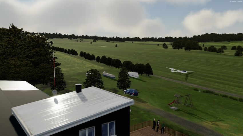
EDGT   BOTTENHORNP3D

Avatar Gerhard
Im Paket von EDGT Bottenhorn ist ein Avatar enthalten, sein Name ist Gerhard. Um ihn
nutzen und steuern zu können, können Sie ihn entweder direkt als Luftfahrzeug über das
Vehicle Menü auswählen und laden ...

… oder Sie können den Avatar auch von ihrem gewählten Luftfahrzeug „lösen“, die
Tastenkombination hierfür ist [Umsch]+[Strg]+[E]. Die Steuerung kann entweder über die
Tastatur oder über ein Gamepad geschehen:

 _______________________________________ 7 _____________________________________
                                © 2020 Bahrometrix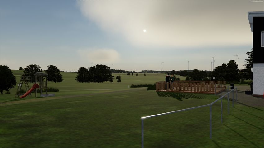
EDGT BOTTENHORNP3D
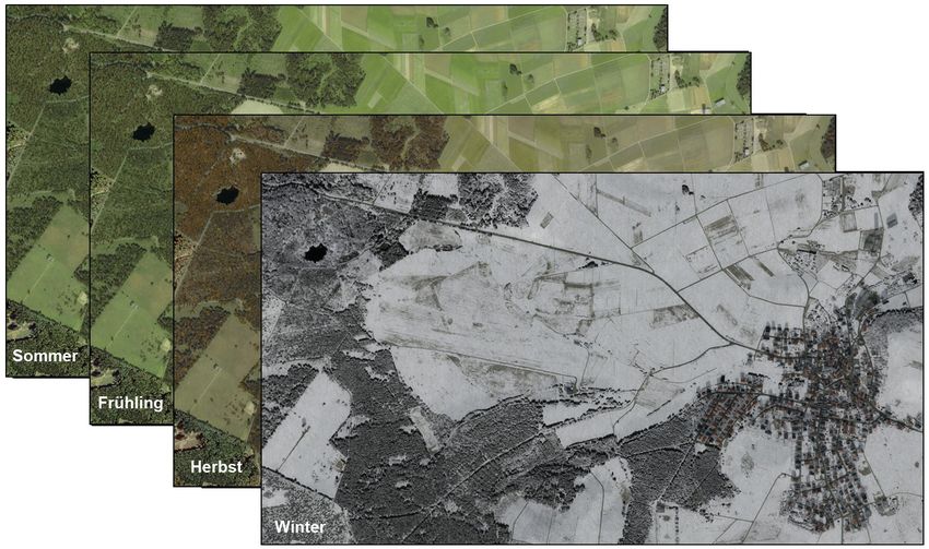
Technische Informationen
Gebietsabdeckung der Orthoszenerie: 10 km²
Luftbildauflösung der Orthoszenerie: 15 cm/px
Auf das Luftbild wurden flächendeckend Gebäude und Vegetation generiert.
Die jahreszeitlichen Variationen des Luftbild
_______________________________________ 8 _____________________________________
© 2020 Bahrometrix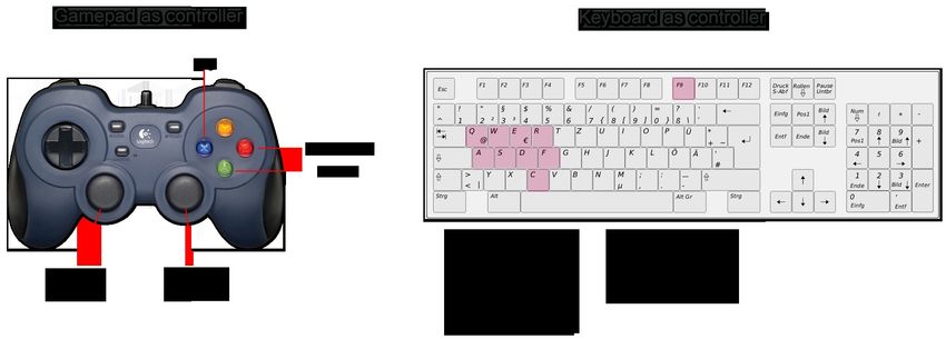
EDGT   BOTTENHORNP3D
                             Sonderlandeplatz EDGT Bottenhorn

              Für die Freunde des Segelflugs ist die LSG Bottenhorn e.V. auf dem Gelände ansässig.

Koordinaten:                            50. 47. 68 N
                                        08. 27. 81 E

Platzrundenhöhe:                        2800 ft MSL

Flugplatzhöhe:                          1657 ft / 505 m

Südplatzrunde:                          5 min. vor Einflug melden

Bahnausrichtung:                        11 / 29
                                        Besonderheiten:
                                        Take Off Runway 29 NICHT ERLAUBT !!!
                                        Landing Runway 11 NICHT ERLAUBT !!!

Bahnlänge:                              525 m

Bahnbelag:                              Gras

Frequenz:                               123.80 MHz

Rufzeichen:                             Bottenhorn INFO

Betriebszulassungen:                    Segelflugzeuge
                                        Motorflugzeuge bis 2 to.
                                        Motorsegler
                                        Ultraleichtflugzeuge
                                        Hubschrauber bis 7,5 to.
                                        Fallschirmspringen

Betriebszeiten:                         PPR

 _______________________________________ 9 _____________________________________
                                © 2020 Bahrometrix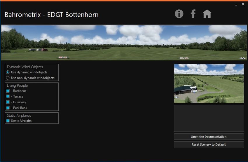
EDGT   BOTTENHORNP3D

Ortschaft Bottenhorn

Der Ortsteil Bottenhorn der Gemeinde Bad Endbach liegt im
Gladenbacher Bergland (östlicher Ausläufer des Westerwaldes, der
sich hier überschneidet mit dem Südausläufer des Rothaargebirges) in
einer wechselhaften Mittelgebirgslandschaft, im Naturpark Lahn-Dill-
Bergland, zwischen den Städten Marburg und Herborn, also mitten im
Hessischen Hinterland. Mit einer Ortskernhöhe von 485 m ü. NN ist
Bottenhorn nach Hülshof die zweithöchstgelegene Ortschaft des
Landkreises Marburg-Biedenkopf.

Naturräumlich wird das Plateau rund um Bottenhorn, das sich vom 552 m hohen
Daubhaus nördlich von Gladenbach bis zum Nordrand des Schelder Waldes (Angelburg
(Berg) 609 m ü. NN) zieht, als Bottenhorner Hochflächen (über 50 km² groß) bezeichnet.
Diese Hochflächen, entstanden im Tertiär, sind eine der ältesten Landoberflächen des
Rheinischen Schiefergebirges.

Bundesland:                     Hessen
Landkreis:                      Marburg-Biedenkopf
Gemeinde:                       Bad Endbach

Höhe:                           485 (485–541,2) m ü. NHN
Fläche:                         8,62 km²
Einwohner:                      1200
Bevölkerungsdichte:             139 Einwohner je km²
Postleitzahl:                   35080
Vorwahl:                        06464

Ortsvorsteher:                  Michael Rombach

_______________________________________ 10 _____________________________________
                               © 2020 Bahrometrix
EDGT BOTTENHORNP3D
Danksagungen / Mitwirkende
Entwickler und Herausgeber: Christian Bahr
Fotoaufnahmen: Ryan (airjuneau)
Handbuch Übersetzung: Ryan (airjuneau)
Animationcontroller
Oliver Binder, www.lorby-si.com
Scenery Configurator LITE
29Palms Scenery Design, www.29palms.de
Beta Test Team
Roland Pohl
Jörg Pagenkemper
Steffen Zuleger
Daniel Born
3-D Objekte
FreeLib-Webseite
Quellennachweise
Orthophoto: Amt für Bodenmanagement Marburg 2018
Geobasisdaten: © OpenStreetMap contributors
Texte Ortschaft Bottenhorn: Wikipedia
Lizenzvereinbarung
Die vorliegende Software ist Eigentum des Herstellers und durch nationale und internationale Urheberrechts-
Bestimmungen geschützt. Jeder, der in der Vergangenheit oder in Zukunft diffamiert und/oder Unwahrheiten
verbreitet und/oder verleumdet und/oder Fake News verbreitet, wer rassistische und/oder rechtsradikale
Inhalte verbreitet, dem wird das Nutzungsrecht an dieser Szenerie entzogen. Für diesen Fall bedarf es dann
einer schriftlichen Genehmigung des Urheberrechtsinhaber das Add-On Mülheim Ruhr X weiterhin
verwenden zu dürfen. Wer trotz Verstoss gegen die Nutzungsbedingungen das Add-On Mülheim Ruhr X
weiterhin und ohne Erlaubnis verwendet, begeht einen Verstoss gegen das internationale Urheberrecht und
gegen die Nutzungsbedingungen.
Ansonsten darf das Add-On ohne weitere Beschränkungen verwendet werden. Der Upload auf Server zum
Zweck der entgeltlichen oder unentgeltlichen Weiterverbreitung ist ohne schriftliche Zustimmung des
Rechteinhabers nicht gestattet. Es ist ebenso unzulässig, ohne vorige schriftliche Zustimmung des
Rechteinhabers die Software oder deren Bestandteile zu dekompilieren und für die Verwendung in anderen
Flugsimulations-Programmen neuerlich zu kompilieren.
Der Entwickler übernimmt keinerlei Haftung für Schäden an Soft- oder Hardware des Nutzers, die aus dem
Betrieb der vorliegenden Software entstehen.
_______________________________________ 11 _____________________________________
© 2020 BahrometrixEDGT BOTTENHORNP3D
Contents
Introduction 13
Installation 14
Scenery Configurator LITE 15
Dynamic Windobjects 16
Avatar Gerhard 17
Technical information 18
Airfield EDGT Bottenhorn 19
Village Bottenhorn 20
Credits / Team 21
License Agreement 21
_______________________________________ 12 _____________________________________
© 2020 BahrometrixEDGT BOTTENHORNP3D
Introduction
Thank you for choosing the EDGT Bottenhorn airfield.
This is the fourth airfield of the "Soar Series". The focus of the series are glider and special
airfields. These airfields are characterized by the fact, that they might have a natural slope
in addition to a grass runway. On the "Soar Series" airfields gliders, ultra-Light's, motor
gliders, towing aircraft, gyrocopters, helicopters, para-gliders and balloon flights may be
allowed.
Thus, this scenery is aimed for VFR aviation.
The combination of orthophotos with the geo data provided by OpenStreetMap creates an
attractive ortho-scene with accurate and dense autogen. It is a great pleasure for friends of
VFR flying, so take your change and visit.
Have fun with EDGT Bottenhorn
Bahrometrix Team
_______________________________________ 13 _____________________________________
© 2020 BahrometrixEDGT BOTTENHORNP3D
Installation
Before installing, deactivate the following files in FTX GES:
...\ORBX\FTX_EU\FTX_EU_GES_05_SCENERY\scenery
- ADE_FTX_GES_EDGT.bgl
- ADE_FTX_GES_EDGT_CVX.bgl
- FTX_GES_EDGT_objects.bgl
Note:
If you haven't got FTX Germany South installed, you can skip the deactivation of the BGL-
files and continue the actual installation. Run the file
P3Dv5_Bahrometrix_EDGT_Bottenhorn_V111.exe and follow the installation instructions.
During the installation you can choose the folder location - so you don't have to install the
scenery into the P3D. At the end of the installation, EDGT Bottenhorn will be automatically
registered as add-on package into the flight simulator.
Uninstall:
To uninstall the scenery you can either use the shortcut at the start menu or the option in
the system control. Please do not forget to re-enable the three ORBX files.
_______________________________________ 14 _____________________________________
© 2020 BahrometrixEDGT BOTTENHORNP3D
Scenery Configurator LITE
After the installation of EDGT Bottenhorn you have to run the configurator to conveniently
adjust the individual needs of the user. It is not necessary to save the changes, they are
adopted directly when the option is set. You can quit the configurator by clicking on Close (X).
The Scenery Configurator Lite comes from 29Palms Scenery Design and was made
available to all freeware developers for free.
Compatibility:
The compatibility is given to: FTX GES, FTX Global, FTX Vector, FTX OpenLC, UTX,
GEX, VFR Germany 2010
_______________________________________ 15 _____________________________________
© 2020 BahrometrixEDGT BOTTENHORNP3D
Dynamic windobjects
The flight simulator Prepar3D does not provide detailed and dynamic wind objects such as
wind turbines and wind vanes, so these wind objects need to be calculated outside the
simulation.
For this purpose, developer Oliver Binder has written the software Windpark_P3D_V5.exe
exclusively for Bahrometrix. It is a wind controller that controls wind objects such as wind
turbines, landing T, wind socks and wind direction indicators on the tower. By controlling
the wind objects, these objects react dynamically to the wind. That means in the example
of the wind turbines, which turn these with wind direction change in the wind and which
rotate the rotor blades with different wind strength different speed. The wind turbines were
programmed according to the data sheet of the manufacturer.
Under the label LORBY-SI, Oliver distributes developed software for the flight simulation.
In addition, he provides numerous free flight simulator software.
_______________________________________ 16 _____________________________________
© 2020 BahrometrixEDGT BOTTENHORNP3D
Avatar Gerhard
The EDGT Bottenhorn Package contains two new avatars, "Gerhard" and "Bambi" (deer).
To be able to use and control them, you can either choose and load him in the vehicle
menu ...
… or you can also detach them from your chosen vehicle. Press the shortcut key [Shift]+
[Control]+[E]. You can control him via a keyboard or a gamepad:
_______________________________________ 17 _____________________________________
© 2020 BahrometrixEDGT BOTTENHORNP3D
Technical information
Area cover of the orthoscenery: 10 km²
Aerial image resolution: 15 cm/px
The aerial image is covered with autogen buildings and trees
The seasonal variation of the aerial image
_______________________________________ 18 _____________________________________
© 2020 BahrometrixEDGT BOTTENHORNP3D
Airfield EDGT Bottenhorn
For the friends of gliding the LSG Bottenhorn e.V. is based on the airfield.
Coordinates: 50. 47. 68 N
08. 27. 81 E
Pattern altitude: 2800 ft MSL
Elevation: 1657 ft / 505 m
South Traffic Pattern: inform 5 min. before landing
Runway direction: 11 / 29
Specifics:
Take Off Runway 29 NOT ALLOWED !!!
Landing Runway 11 NOT ALLOWED !!!
Runway length: 525 m
Surface: Grass
Frequency: 123.80 MHz
Callsign: Bottenhorn INFO
Type of Traffic permitted: gliders
airplanes 2t MTOW
powered gliders
ultralights
helicopter 7,5t MTOW
skydiving
Operating Time: PPR
_______________________________________ 19 _____________________________________
© 2020 BahrometrixEDGT BOTTENHORNP3D
Village Bottenhorn
The village Bottenhorn in the community Bad Endbach is located in the
mountainous area of Gladenbach (eastern foothills of the Westerwald,
which overlaps here with the southern foothills of the Rothaargebirge)
and in the varying mountain landscape of the nature park Lahn-Dill
Bergland between the cities Marburg and Herborn. Right in the middle
of the Hessian Hinterland. With a height of 485 m above sea level is
Bottenhorn next to Hülshof the second highest town of the county
Marburg-Biedenkopf.
The plateau around Bottenhorn, which rises from the 552 m high Daubhaus north of
Gladenbach to the northern edge of the Schelder forrest (Angelburg 609 m above sea
level), referred to as Bottenhorner High (over 50 square kilometers in size).These
plateaus, created in the Tertiary, are one of the oldest land surfaces of the Rheinischen
Schiefergebirges.
Federal State: Hesse
County: Marburg-Biedenkopf
Community: Bad Endbach
Elevation: 485 (485–541,2) AMSL
Area: 8,62 km²
Population: 1200
Population Density: 139 Einwohner je km²
Postal code: 35080
Dialing code: 06464
Mayor: Michael Rombach
_______________________________________ 20 _____________________________________
© 2020 BahrometrixEDGT BOTTENHORNP3D
Credits / Team
Lead Developer and Publisher: Christian Bahr
Photos: Ryan (airjuneau)
Translation Manual: Ryan (airjuneau)
Animationcontroller
Oliver Binder, www.lorby-si.com
Scenery Configurator LITE
29Palms Scenery Design, www.29palms.de
Beta Test Team
Roland Pohl
Jörg Pagenkemper
Steffen Zuleger
Daniel Born
3-D Obects
FreeLib-Website
Source
Orthophoto: Amt für Bodenmanagement Marburg 2018
Spatial Geodata: © OpenStreetMap contributors
Text Village Bottenhorn: Wikipedia
License Agreement:
The software on hand is property of the manufacturer and by national and international copyright regulations
protectedly. Anyone who defames in the past or future and / or disseminates untruths and / or slanders and /
or disseminates fake news, who disseminates racist and / or right-wing extremist content is deprived of the
right to use this scenery. In this case, written permission from the copyright holder is required to continue
using the Mülheim Ruhr X add-on. Anyone who continues to use the Mülheim Ruhr X add-on without
permission despite violating the terms of use commits a violation of copyright and the terms of use.
Every other use, it is direct or indirect or completely or in parts, requires the express written consent of the
right holder. The upload on servers to an end of the against payment propagation free of charge is not
allowed without a written consent of the right holder. It is just as inadmissible to decompile the software or its
components without a previous written consent of the right holder and to compile in other flight simulation
programmes for the use lately.
The developer assumes no liability for damages to soft or hardware of the user which result from the
operation of the software on hand. All rights reserved.
_______________________________________ 21 _____________________________________
© 2020 BahrometrixSie können auch lesen