Hassi Berkane and Late Iberomaurusian Land Use in the Eastern Rif, Morocco
←
→
Transkription von Seiteninhalten
Wenn Ihr Browser die Seite nicht korrekt rendert, bitte, lesen Sie den Inhalt der Seite unten
doi: 10.7485/QU66_10                                                                                      Quartär 66 (2019) : 201-223

Hassi Berkane and Late Iberomaurusian Land Use
in the Eastern Rif, Morocco
Hassi Berkane und die Landnutzung im späten Ibéromaurusien im östlichen Rif,
Marokko

Taylor Otto1,2,*, Helmut Brückner3 & Gerd-Christian Weniger1,2
1
  CRC 806 Project C1, Institute of Prehistory, University of Cologne, Weyertal 125, 50923 Cologne, Germany;
  email: otto@neanderthal.de
2
  Neanderthal Museum, Talstraße 300, 40822 Mettmann, Germany
3
  Institute of Geography, University of Cologne, 50923 Cologne, Germany

Abstract - Previous studies have shown that climate events have the potential to significantly impact hunter-gatherer land
use patterns in the Western Mediterranean. Especially Heinrich Event 1 (18-15.6 ka calBP) affected the long-term stability of
Magdalenian groups on the South of the Iberian Peninsula, while it did not impact the contemporaneous Iberomaurusian
groups in Morocco to the same degree. It remains unclear which role the mass exploitation of land snails, beginning in
Greenland Interstadial 1 (from ca. 15.6 ka calBP), played in the establishment of these land use patterns. To examine this
further, studies on a regional scale are needed.
     Survey projects in the Eastern Rif of Morocco led to the discovery of multiple new Late Iberomaurusan sites, one of these
being Hassi Berkane, discovered in 2013 and surveyed intensively in 2014. This paper presents the results of these works and
ties Hassi Berkane into the Late Iberomaurusian landscape of the Eastern Rif. Together with other sites, such as Ifri el Baroud
and Ifri n’Ammar, we were able to analyze settlement orientation and mobility patterns. These show that the Late Iberomau-
rusian groups chose site locations mainly based on fresh water sources and were mobile in daily activities, but not particularly
mobile outside of ranges accessible in a day’s walk. This impression of a fairly immobile society can be linked to previous land
use models which point to considerable settlement stability for Moroccan hunter-gatherers during GI1 and the Younger Dryas
(ca. 15-11.7 ka calBP).

Zusammenfassung - Das Spätglazial im westlichen Mittelmeergebiet ist durch starke Klimaschwankungen sowie Schwankungen
in der Populationsdichte und damit verbundenen Änderungen der Siedlungssysteme gekennzeichnet. Im Süden der Iberischen
Halbinsel hatte vor allem das Heinrich Event 1 negativen Einfluss auf die Landnutzungsmuster der paläolithischen Gemein-
schaften, während die zeitgleichen Jäger-Sammler-Gruppen in Marokko davon weitgehend unberührt blieben. In der vorlie-
genden regionalen Studie werden Landnutzungs- und Mobilitätsstrategien des Späten Ibéromaurusien in Nordostmarokko unter-
sucht. Ausgangspunkt ist die Entdeckung der Fundstelle Hassi Berkane mit Siedlungsspuren vom Jungpaläolithikum bis zum
Neolithikum.
     Das Felsschutzdach Hassi Berkane liegt östlich des gleichnamigen Dorfes im marokkanischen Rif auf einem Hang oberhalb
eines ehemaligen spanischen Forts aus dem Beginn des 20. Jahrhunderts (Abb. 2). Zwischen Fort und Felsschutzdach befindet sich
eine Süßwasserquelle, die das Zentrum der Fundstelle bildet. In Gräben um das Fort waren bereits bei der Entdeckung der
Fundstelle Siedlungsschichten sichtbar. Dabei handelt es sich um Reste einer „Escargotière“, die durch große Mengen terrestrischer
Schneckenschalen, Steinwerkzeuge und Aschenlagen charakterisiert ist. Aufgrund der Begehung kann die gesamte Siedlungs-
fläche auf ca. 2 000 m2 geschätzt werden, mit der Quelle im Zentrum. Die offenen Gräben wurden 2014 an mehreren Stellen
gesäubert und es wurden zwei Bohrungen durchgeführt (Abb. 3). Aus den Bohrkernen und einem der Profile wurden Sinter- und
14
   C-Proben entnommen. Die radiometrischen Datierungen stellen die Besiedlung in das Späte Ibéromaurusien, das Epipaläoli-
thikum und das Späte Neolithikum (Abb. 4). Unter dem Humushorizont a liegt das mehrfach gegliederte Sediment der Escargo-
tière, das sich in die Schichten b (z.B. b1/2), c, d und e gliedert. Die Sequenz wird durch den anstehenden Hangschutt f abgeschlossen.
Artefakte stammen vorwiegend aus dem Schichtkomplex b sowie aus der Schicht f.
     Insgesamt wurden aus den Bohrkernen, dem Profil OW-W sowie von der Oberfläche 314 Funde geborgen; hiervon sind 224
Steinartefakte, 68 unbestimmbare Tierknochen und 16 Fragmente von Straußeneischalen. Sechs Keramikscherben von der
Oberfläche stammen wahrscheinlich von der modernen Nutzung des Platzes. Das meiste Material stammt aus Schicht b der Escar-
gotière; nur wenige undiagnostische Artefakte stammen aus der Basisschicht f. Die Artefakte von der Oberfläche können keiner
der drei Siedlungsphasen eindeutig zugeordnet werden. Lithische Rohmaterialien wurden vorwiegend aus Schottern der Moulouya
in ca. 10 km Entfernung gesammelt. Nur ein Artefakt stammt womöglich von der etwa 64 km entfernten Rohmaterialquelle Ain
Zora. Ein menschlicher Zahn wurde ohne sicheren stratigraphischen Zusammenhang geborgen (Abb. 7).

*corresponding author

                                                                                                                                  201
Quartär 66 (2019)                                                                                                      T. Otto et al.

     Hassi Berkane gehört zu einer Serie von Fundplätzen mit Inventaren des späten Ibéromaurusien wie Ifri el Baorud, Ifri n’Ammar,
Hassi Ouenzga plein air und Ifri Armas. Die Verteilung der Fundstellen wurde mit Kerndichteschätzungen untersucht und ihre
Einzugsgebiete mit der Site Catchment Analyse. Die Einzugsgebiete gliedern sich in ein tägliches Schweifgebiet (daily range), das
innerhalb eines Tages genutzt werden kann, und in ein Rohmaterialbeschaffungsgebiet (procurement range). Die Kerndichte-
schätzung zeigt keine klaren Fundstellencluster, sondern eine eher gleichmäßige Verteilung über die Landschaft (Abb. 8). Gemäß
der Analyse der täglichen Einzugsgebiete orientierte sich die Lage der Fundstellen stärker an Süßwasserquellen orientierte als an
den lithischen Rohmaterialquellen. Allerdings liegen letztere im täglichen Schweifgebiet oder nur knapp darüber (Abb. 11). Dies
deutet darauf hin, dass die Gruppen vor allem in ihren täglichen Bewegungen recht mobil waren, über die täglichen Schweifge-
biete hinaus aber nur eine geringe Mobilität erkennen lassen. Sie bewegten sich lediglich in einem kleinen Gebiet innerhalb des
östlichen Rifs (Abb. 13). Dieser Trend zu hoher lokaler Mobilität bei gleichzeitig geringer regionaler oder überregionaler Mobilität
kann als Indiz für günstige Habitatbedingungen verstanden werden und unterstützt damit Ergebnisse früherer Arbeiten aus der
Region.

Keywords - Iberomaurusian, Morocco, Land use, GIS, Heinrich Event 1
              Ibéromaurusien, Marokko, Landnutzung, GIS, Heinrich Event 1

Introduction                                                         a lithic industry that is is based on microlithic backed
                                                                     bladelets and points, which often make up the bulk of
The Late Glacial in the westernmost Mediterranean is                 the assemblages (Bouzouggar et al. 2008; Potì 2017).
marked by strong fluctuations in climate, population                 Many instances of burials, traces of pigment use,
densities and land use strategies (Barton et al. 2018;               ornaments, and few examples of rock and mobile art
Weniger et al. 2019). These fluctuations are inherently              attest to a particularly rich Late Iberomaurusian
linked, climate having the potential to significantly                culture (Moser 2003; Nami 2007; Bouzouggar et al.
influence hunter-gatherer behavior (Stein Mandryk                    2008; Mariotti et al. 2009, Olszewski et al. 2011; Potì
1993). Especially Heinrich Event 1 (HE1) (18-15.6 ka                 2017). Especially the subsistence spectrum is inter-
calBP) (Sánchez Goñi & Harrison 2010) impacted site                  esting: the Iberomaurusian groups hunted different
distribution, site numbers and social networks in the                species of large herbivores (among others large
Western Mediterranean, especially in the South of the                quantities of barbary sheep) (Potì 2017) and collected
Iberian Peninsula (Weniger et al. 2019). This climate                wild plants (Humphrey et al. 2014), but also consumed
event did not have the same effect on the contempo-                  large quantities of edible terrestrial snails and left
raneous neighbors in Morocco, however; the Late                      their shells behind, forming often massive shell
Glacial groups here show signs of settlement stability               middens (escargotières) in the sites (Lubbel 2004;
throughout the period of extreme climate fluctuations                Hutterer et al. 2011; Linstädter 2014). Such sites are
between HE1 and the Younger Dryas (YD) (18-11.7 ka                   spread along North Africa, from the Atlantic coast of
calBP) (Weniger et al. 2019). The approach in Weniger                Morocco to the northeastern Littoral of Libya.
et al. (2019) focused on examining supra-regional                    Although the sites concentrate on the coastal regions,
trends in Palaeolithic settlement systems; until now,                they are also found farther inland (Potì 2017). The
regional analyses are rare (Barton et al. 2018). Such                earliest evidence of the Iberomaurusian was identified
studies have the potential to identify more local devel-             in Tamar Hat, in Algeria, dating to ca. 25 ka calBP
opments and allow us to incorporate additional, site-                (Hogue & Barton 2016). In Morocco, first evidences
specific data and identify new patterns. In this paper,              are slightly younger. The techno-complex can be
we focus on a small region in Northeastern Morocco,                  divided into two phases, an Early Iberomaurusian,
the Eastern Rif (Fig. 1), and present Late Iberomau-                 dating to Greenland Stadials 2.1a-b-c (ca. 23-15 ka
rusian sites dated to Greenland Interstadial 1 (GI1)                 calBP), and a Late Iberomaurusian, corresponding to
and the Younger Dryas (ca. 15-11.7 calBP, following                  Greenland Interstadial 1 and the Younger Dryas
Rasmussen et al. 2014). Recent studies in the region                 (ca. 15-11.7 ka calBP) (Linstädter et al. 2012a; Potì et al.
led to the discovery of a new site, Hassi Berkane, which             2019a; Potì et al. 2019b; Weniger et al. 2019). Traces
will be presented first. This new site adds to the                   from the earlier phase are rare in the Maghreb, and
archaeological record of the Late Iberomaurusian and                 only represented by few sites, such as Ifri el Baroud
gives us new data with which we can analyze land use                 (Potì et al. 2019b) and Taforalt (Barton et al. 2013).
on a regional scale.                                                 More sites are known from the later phase, where we
                                                                     also see an increase in settlement activity and the
The Iberomaurusian in the Eastern Rif                                aforementioned regular formation of shell middens
                                                                     comprised of terrestrial molluscs (Taylor et al. 2011;
(Morocco)
                                                                     Linstädter et al. 2012a; Weniger et al. 2019). The
                                                                     Iberomaurusian ends with the end of the Pleistocene,
The Upper Palaeolithic of Morocco is described as the                transitioning into the Holocene Epipalaeolithic
Iberomaurusian. Sites from this techno-complex share                 (Linstädter et al. 2012a).

202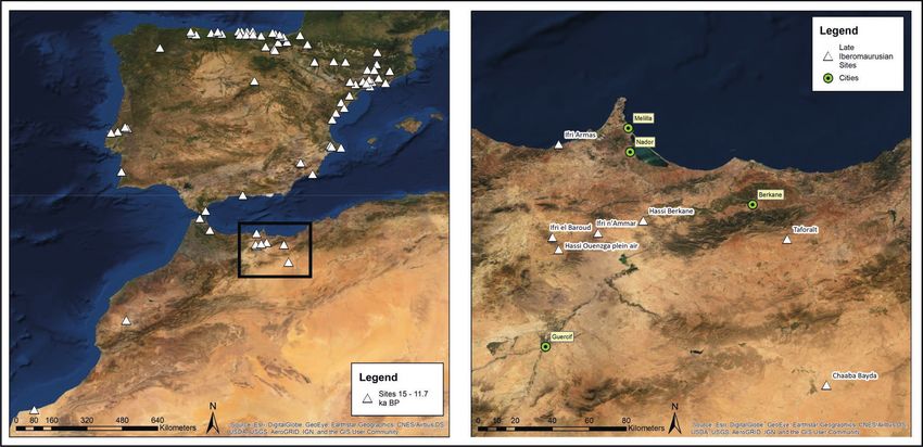
Hassi Berkane and Late Iberomaurusian Land Use in the Eastern Rif, Morocco Quartär 66 (2019)
Fig. 1. Palaeolithic sites in the westernmost Mediterranean (Iberian Peninsula and Morocco) dated to Greenland Interstadial 1 (GI1) and
Greenland Stadial 1 (GS1) (15-11.7 ka calBP).
Abb. 1. Paläolithische Fundstellen im Westlichsten Mittelmeerraum (Marokko, Spanien, Portugal) aus dem Grönland Interstadial 1 (GI1) und
Grönland Stadial 1 (GS1) (15-11.7 ka calBP).
Until now, it is still unclear how the exploitation of the Early as well as the Late Iberomaurusian (22.7-12.9
land snails influenced the mobility and settlement ka calBP), and documents the sedimentological
pattern of the Late Iberomaurusian hunter-gatherers. transition from fine-grained, sandy cave sediments of
A simple assumption would be that we can identify a the early phase (layers C and D) to the shell midden of
link between the mobility patterns of a society and the later phase (layers B1 and B2), the latter of which
the mobility level of an important faunal resource corresponds to Greenland Interstadial 1. The
(Linstädter 2014). This must, however, be examined in sequence and lithic material from this site is presented
detail. To shed light on this issue, we must first charac- in detail in Potì (2017) and Potì et al. (2019a, b). The
terize the mobility and settlement patterns of Late authors could document a shift in technology from the
Iberomaurusian groups in the Maghreb. Early to the Late Iberomaurusian along with a change
The Eastern Rif in Morocco was the focus of a of the raw material procurement strategy
20-year long fieldwork and survey campaign, (Potì et al. 2019b).
conducted by the University of Cologne within the The neighboring site Ifri n’Ammar has yielded a
framework of the CRC 806 – “Our way to Europe”, the particularly long stratigraphical sequence, spanning
Kommission für die Archäologie Außereuropäischer into the Middle Palaeolithic. In addition to a substantial
Kulturen (KAAK) of the German Archaeological lithic collection, presented and analyzed (Moser 2003),
Institute (DAI), and the Institut National des Sciences multiple human burials and other facets of a particu-
de l’Archéologie et du Patrimoine (INSAP), which had larly rich culture were identified from the Late Ibero-
begun in 1995 (Mikdad & Eiwanger 2000). This project maurusian layers, which also broadly date to Greenland
led to the discovery of over one hundred sites from Interstadial 1. The shell midden in Hassi Ouenzga
the Pleistocene to the Holocene including several Late plein air can be attributed to the same time frame.
Iberomaurusian sites: Ifri n’Ammar (Moser 2003), Ifri This site is located in the direct vicinity of the Epipalae
Armas (Lorenz 2010), Hassi Ouenzga plein air olithic and Neolithic site Hassi Ouenzga abri
(Linstädter et al. 2012a), Ifri el Baroud (Potì et al. (Linstädter 2004); the assemblage and stratigraphy
2019a), and finally Hassi Berkane, all in the direct were analyzed by Jörg Holzkämper as part of a
neighborhood of previously discovered contempora- research stipend from the German Archaeological
neous sites Chaaba Bayda (Wengler & Vernet 1992) Institute (DAI) (J. Holzkämper, unpubl. data).
and Taforalt (Barton et al. 2013). The newly described The final site from the region, Ifri Armas, is also
site, Hassi Berkane, was discovered in 2013 during better known for its younger material from the
surveying and revisited in 2014 and 2015 for detailed Epipalaeolithic and Neolithic (Lorenz 2010). However,
prospection; results from these analyses will be a directly dated human bone along with other radio-
presented in this paper. metrically dated material adds it to the list of Late
Ifri el Baroud was excavated in 1995–1996 and Iberomaurusian sites of the Eastern Rif. Unfortunately,
again in 2015 (Potì et al. 2019b). The sequence spans the stratigraphy of this site is highly mixed, and,
203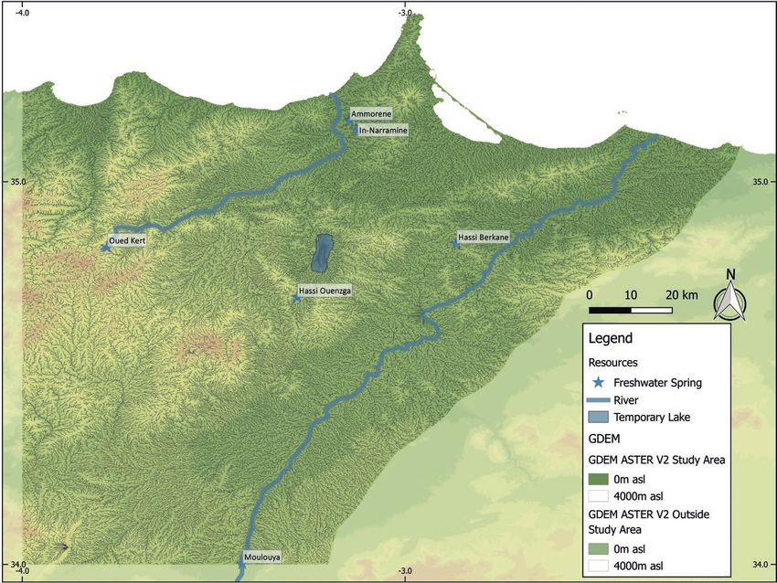
Quartär 66 (2019)                                                                                        T. Otto et al.

although the dates show human presence during               Spectrometry, University of Cologne), U-series dating
Greenland Interstadial 1 and the Younger Dryas, we          by the Institute of Geosciences, Johannes Gutenberg-
cannot be sure of the nature of the site’s use as no        Universität Mainz (Denis Scholz). 14C ages were
intact Late Iberomaurusian assemblage could be              calibrated with CalPal using the CalPal-2007 Hulu
singled out from the material.                              calibration curve (Weninger & Jöris 2008), the
    Each of these sites yielded radiometric ages which      summed probability distribution of radicarbon ages
calibrate to the time frame between 15 and 11.7 ka          for Hassi Berkane along with the other Eastern Rif sites
calBP, a microlithic, bladelet-based lithic industry, and   was done in R, using the package rcarbon (Bevan &
ashy, snail-shell rich sediments. These cultural and        Crema 2020) and the Intcal13 curve (Reimer et al.
chronological similarities allow the grouping of all of     2013).
these sites into one Late Iberomaurisian techno-                 The contextualization of Hassi Berkane along with
complex, for which we assume broad cultural similar-        the other Late Iberomaurusian sites in the Eastern Rif
ities. Although individual local and temporal fluctua-      was done by linking them to each other as well as to
tions need to be accounted for and may not be repre-        the landscape using three proxies: site location,
sented in the following analyses, we think it appro-        resource location in the landscape, and resource use
priate to group these sites together in order to            in the sites. With such an approach, we aim to under-
contextualize them in the landscape and obtain first        stand the cultural dynamics behind site location and
estimates of Late Iberomaurusian land use behavior.         site formation, by analyzing why prehistoric groups
    The goal of this paper is to characterize mobility      chose to settle in which locations (population distri-
and settlement pattern for the Late Iberomaurusian,         bution and settlement orientation) and how they
as a prerequisite for the discussion on the role of         moved through the landscape (mobility).
terrestrial molluscs in the hunter-gatherer subsistence          Population distribution is represented in archaeo-
spectrum. We therefore focus on the small region in         logical contexts by site distribution (Renfrew & Bahn
Northwestern Morocco with data from sites obtained          1996). This is not always straightforward, as the
during the course of one long-term research project,        archaeological record is always selective of that which
allowing a certain degree of comparability between          it represents, due to preservation, research history or
the site archives. We aim to provide a first sketch of      other biases (Hodder & Orton 1976; Straus et al.
possible regional land use, settlement and mobility         2000). A basic assumption behind site distribution
behavioral patterns which can be used as a basis for        analysis is that the locations of archaeological sites
further analyses.                                           follow some logic, initially unknown to us (Hodder &
                                                            Orton 1976). We aim to understand this logic by
Methods                                                     looking for patterns in the distribution and inter-
                                                            preting them.
We applied a number of methodological approaches                 Another underlying assumption discussed by
to analyzing land use and mobility patterns of the Late     Hodder & Orton (1976) is that site distribution is
Iberomaurusian in the Eastern Rif. To integrate Hassi       inherently linked to resource distribution. We term
Berkane into the setting of Late Iberomaususian sites       this concept settlement orientation. If a clustered site
we carried out special field work and lab analyses.         pattern is recognized in the Kernel Density Estimation,
During the survey we cleaned open profiles in multiple      we can hypothesize that this pattern represents local
areas, took two sediment drill cores, and collected         foci on certain resources in the landscape resources.
artifacts from the surface of the whole settlement          The question of which resources a site is oriented
area. The statigraphy of the drill cores was described      towards can be answered using Site Catchment
in detail and, when possible, Munsell sediment soil         Analysis. A site’s catchment is defined as “that area
color codes were given (Munsell 2000). From the drill       from which a site (or more properly, the inhabitants of a
cores and the profiles, organic material and flowstone      site) derived its resources” (Roper 1979: 120), and can
samples were taken in order to determine the                be divided into different zones. The zone from which
chronology of the site.                                     inhabitants of a site undertake their daily activities,
    The typology and technology of the lithic assem-        such as foraging and hunting, can be defined as the
blages was described following Tixier 1963 and raw          foraging radius or daily range, an “…area searched
material was classified macroscopically based on            and exploited by work parties who leave the camp to
samples and references in Linstädter & Müller-              exploit the environment and return home in a single
Siegmund (2012) and Götz (2016). As the chrono-             day” (Binford 1982: 7). Identifying the size of this
cultural attribution of sites with microlithic, bladelet-   range and mapping the resources accessible in this
based assemblages in the Eastern Rif cannot suffi-          area around a site can tell us – possibly – which
ciently be carried out with lithic analysis alone,          resources the site’s location was oriented towards.
especially with such a small assemblage as is present in         Two types of resources were utilized for this
Hassi Berkane (Linstädter et al. 2012a), radiometric        analysis: lithic raw material and fresh water. Spatial
dating of the layers was needed. 14C dating was carried     analysis on the basis of faunal data is outside the scope
out in the CologneAMS (Centre for Accelerator Mass          if this paper, which is to be seen as a preliminary land

204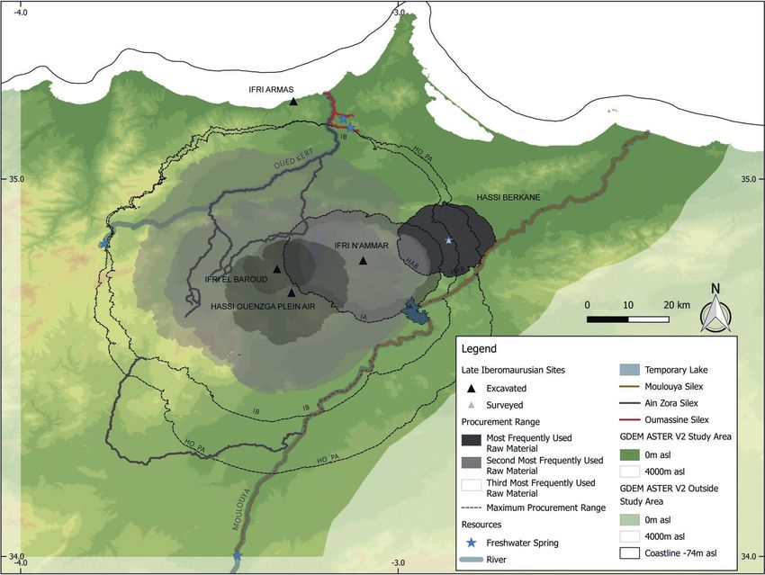
Hassi Berkane and Late Iberomaurusian Land Use in the Eastern Rif, Morocco                                Quartär 66 (2019)

use characterization that can be expanded with the              the procurement ranges of each lithic raw material was
inclusion of such additional data. Lithic resources were        colored and shaded according to the frequency with
mapped according to previous project results                    which the material was found in the site.
(Linstädter & Müller-Siegmund 2012; Götz 2016).                     Examining the resources available in the daily
These survey activities showed that cherts from                 range allows us to identify potential driving factors
different primary sources are transported far into the          behind site location, while analyzing the procurement
region along wadi channels, and, therefore, using only          ranges helps us to discuss hunter-gatherer mobility
the surveyed chert locations for the analysis appeared          potential. These analyses, paired with the result of the
not to sufficiently reflect the situation on the ground.        Kernel Density Estimation, allow us to obtain insight
For this reason, we modeled potential fluvial transport         into the Late Iberomaurusian land use strategies of the
routes of these materials downstream from survey                Moroccan Eastern Rif. All analyses were performed in
points, by calculating a stream network model with              ArcGIS 10.3.
ArcGIS 10.3 using the Flow Accumulation function
(Esri, Flow Accumulation) on the basis of the Digital           Hassi Berkane
Elevation Model ASTER GDEM V2 (JPL 2009). Values
were isolated out of the flow accumulation map if they          The rock shelter site of Hassi Berkane (2.87 W,
exceeded 100, an arbitrary threshold selected to                34.84 N) is named for the small village in Northeastern
ensure a particularly high resolution of the model.             Morocco, located between the Western foothills of
     Mobility for resource procurement can extend               the Beni Snassen mountains and the Eastern outskirts
outside of the area in the immediate vicinity of a site,        of the Rif mountain range (Er-Rif) (Fig. 1). The site itself
however. Exploitation outside of this range can be              is situated to the East of the small town, on a hillside
conceptualized as logistical procurement (Binford               above an abandoned Spanish fort built at the
1980), and the corresponding area utilized – the logis-         beginning of the 20th century (Fig. 2). Some 50 m to
tical radius – is “the zone which is exploited by task          the south of the fort are the rock shelter and fresh-
groups who stay away from the residential camp at               water spring which form the center of the site. An up
least one night before returning” (Binford 1982: 7). We         to 2 m thick, ashy, snail-shell rich archaeological layer
can visualize such areas where resource procurement             (escargotière) is visible in ditches around the fort’s
was undertaken outside of the daily range using lithic          outer walls as well as superficially beneath the rock
raw materials (Maier et al. 2016), by linking the artifacts     shelter, allowing a gross estimate of the prehistoric
found in the sites back to their sources in the landscape.      settlement activity in a 2 000 m2 area around the
This analysis is based solely on lithic raw materials, and      freshwater spring. In addition to settlement traces
not typology or technology; accordingly, even small             found in this area, the team also found sporadic traces
assemblages can be used for such an analysis, although          of human occupation (lithic material) on the large
resulting possible biases must kept in mind during the          hillside to the North of Hassi Berkane proper (this new
interpretation of the results. We utilize Binford’s             hillside named Hassi Berkane North), attesting to rare
(1982) concept of embedded procurement to                       anthropogenic use of a currently undetermined
demarcate areas used not only for lithic resource               nature.
collection, but also assume that other procurement
activities, such as hunting, were undertaken in these           Stratigraphy
ranges. The resulting maps reflect mobility potential,          Six onsite profiles were documented: two in the ditch
and show broadly circular ranges, encompassing areas            along the outer wall of the fort (Western and Eastern
not only in the direction of the lithic raw material            “Outer Wall” profiles, OW-W and OW-E), two in the
source itself, but in all directions, to serve as a clearer     drainage ditch leading away from the fort (Northern
visualization of distances from a site that were poten-         and Southern “Drainage Ditch” profiles, DD-N and
tially utilized by hunter-gatherer groups.                      DD-S), and the two drill cores (HBE1 and HBE2), one
     For the analysis of the site or population distri-         taken from underneath the rock shelter (HBE1) and
bution, we applied Kernel Density Estimation (Baxter            the other in the center of the site (HBE2) (Figs. 2 & 3).
et al. 1997), using the automatic bandwidth calculation         Each profile and drill core was photographed, while
by ArcGIS 10.3. To model the different ranges around            one profile (OW-W) and both drill cores were
each site, we applied the method of Site Catchment              additionally described in more detail. The locations
Analysis presented by Becker et al. (2017) using                of all finds, samples and structures in the cores were
Tobler’s hiking function. These cost-distance maps              measured with DGPS.
were divided into a daily range of 4h walking time, to              All profiles show the same general stratigraphical
ensure travel, procurement and return in one day                sequence. Underneath a brown surface layer a (which
(Kelly 1995), and the procurement range (more                   is missing in some profiles) lies the highly heteroge-
neutrally renamed from logistical range), defined by            neous escargotière b, divided into multiple sub-layers
the source locations of lithic raw material identified in       based on color, composition or delimitations by layers
the sites. The 4h daily ranges were color coded                 of large stones. In all profiles, a lighter brown layer f
according to the resources available in the range, and          was documented underneath the midden.

                                                                                                                       205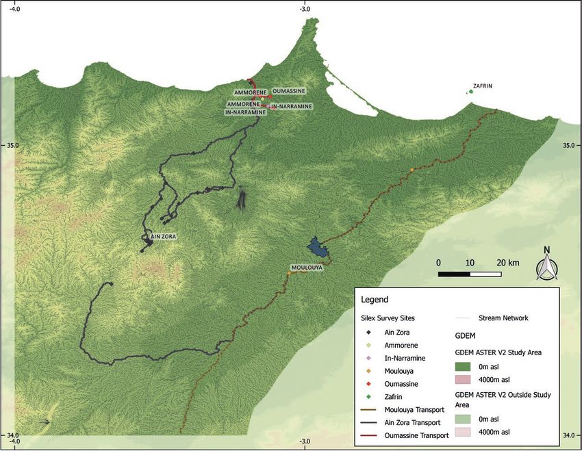
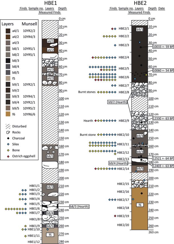
Quartär 66 (2019)                                                                                                                     T. Otto et al.

  Fig. 2. Situation in Hassi Berkane. a: digitized profiles; b: profile photos; c: situation of the site with location of the profiles (OW-E:
  profile Outer Wall East; OW-W: profile Outer Wall West; DD-N: profile Drainage Ditch North; DD-S: profile Drainage Ditch South;
  HBE1: drill core HBE1; HBE2: drill core HBE2).
  Abb. 2. Situation in Hassi Berkane. a: digitalisierte Profile; b: Profilfotos; c: Situation der Fundstelle mit Lokalisierung der Profile (OW-E:
  Profil Outer Wall East; OW-W: Profil Outer Wall West; DD-N: Profil Drainage Ditch North; DD-S: Profil Drainage Ditch South; HBE1:
  Bohrkern HBE1; HBE2: Bohrkern HBE2).

206
Hassi Berkane and Late Iberomaurusian Land Use in the Eastern Rif, Morocco Quartär 66 (2019)
Archaeological finds stem from the midden layers as As the lithic tradition of the Iberomaurusian
well as from the underlying sediments. All profiles show continues into the Holocene Epipalaeolithic, it is
signs of running water, mainly in the form of sinter, most difficult to date a post-Middle Palaeolithic site in this
likely linkable to the freshwater spring at the site. This is region on the basis of lithic typology and technology
most prominent in the profile OW-W, where the alone, especially when the assemblage collected is as
sediments are cemented by precipitated CaCO3. small as it is in Hassi Berkane (Linstädter et al. 2012a).
The surface layer a is likely post-Neolithic or even For this reason, the chrono-cultural attribution of the
modern, yielding no artifacts. Layer complex b repre- assemblages is based solely on 14C-dated samples
sents the core of the site, made up of fine, gray, ashy from the drill core HBE2 and the U/Th dating of the
sediment, many stones and especially terrestrial aforementioned flowstone from OW-W (Fig. 4). The
gastropod shells. The main bulk of artifacts with age estimates document the use of the site during the
recorded stratigraphical information was found in this Late Iberomaurusian, Epipalaeolithic as well as the
layer. The large amount of snail shells is frequently Neolithic. The thin sinter layer in OW-W, situated
interpreted as remnants of prehistoric meals, marking between two layers of escargotière, yielded a date of
an intensive, possibly residential settlement of the site 5.4 ± 0.43 ka, indicating that portions of the shell
(Taylor et al. 2011; Barton & Bouzouggar 2013; midden in the front of the site, toward the fort, likely
Hutterer et al. 2014). Multiple hearths were identified formed in the Late Neolithic. The dates from the drill
in both drill cores, marked by clusterings of charcoal core in the center of the site (HBE2) attest to a
and burnt stones. two-phase occupation: one at the beginning of the
Layers c and d are local phenomena only recorded Late Iberomaurusian, shortly after 15 ka calBP, and one
in the profile OW-W, possibly linked to increased at the beginning of the Epipalaeolithic (Linstädter et
hydrological activity. c is a compact reddish discol al. 2012a).
oration in the escargotière, and d is a thin sinter layer To examine the contemporaneity of the Hassi
underlying c. From here, samples were taken for U/Th Berkane settlement with that of other sites in the
dating. Underneath these two layers, an escargotière is region, we calculated summed probability distribu-
visible again. This portion of the midden is particu- tions of each site’s Iberomaurusian radiocarbon dates
larly cemented, and this cemented layer continues to (Appendix, Tab. 2 & Fig. 5). The Late Iberomaurusian
the East and is visible in the neighboring profile OW-E. dates from Hassi Berkane clearly overlap with those
This cementation includes the lower portions of the from Ifri el Baroud, Ifri n’Ammar and Hassi Ouenzga
escargotière as well as the upper portions of the plein air. The early Epipalaeolithic ages from the site,
underlying layer f, the bottom of which is visible in all which calibrate to the very beginnings of the Holocene,
profiles, marking the lower limit of the sequence. are slightly younger than the youngest ages from Hassi
Layer f is not completely sterile, as few artifacts were Ouenzga plein air and contemporaneous with one
found in drill core HBE2. In the open profiles OW-E isolated early Holocene date from Ifri n’Ammar
and OW-W, the loose portion of the layer is eroded (Erl-4394). This shows that they can be considered
and only larger stones cemented with the upper broadly contemporaneous in the sense of an archaeo-
portion of the sequence remain. logical techno-complex.
More archaeological material was found in HBE2
than in HBE1 (Fig. 3 & Appendix, Tab. 1). In both cores, Archaeological material
there is a clear focus of the distribution on the escar- A total of 314 artifacts were collected from the surface
gotière layers. In HBE1, we can see a concentration of or extracted from the profiles. The main portion of
faunal remains on the presumed hearth structure artifacts are lithics, making up 224 of the total pieces
b8/3, with other material found more evenly, but in accounted for; they derive from the surface, the drill
lower amounts, throughout the midden sequence. In cores as well as from the profile OW-W. In addition to
the other drill core, many artifacts were found in the these, the next largest find group is faunal remains,
hearth structure b9/2, but the second probable hearth comprising of 68 bone fragments and 16 ostrich
b9/4 yielded no artifacts; The bulk of the remains and eggshell pieces. Six pieces of ceramics were found on
lithics were recovered from the middens themselves, the surface as well, likely originating from modern use
mostly from the lower part of b9/1 and around the of the site.
small layer of stones in b9/3. Lithics were also recovered The techno-typological analysis of the lithics is
from the layers f5 and f6. In f5, two pieces were found based on Tixier 1963. The assemblage is comprised of
in the transition zone from the escargotière to the 24 pieces from HBE1, 91 from HBE2, nine from the
underlying sediment, while four pieces can sufficiently profile OW-W, and 100 from the surface (85 from the
be attributed to the pre-Late Iberomaurusian layer in area between the rock shelter and the fort, and 15
HBE2. These are the only remains attesting to an from the area above the rock shelter).
earlier settlement of the site; unfortunately, the pieces 36 artifacts stem from the younger part of the
are not diagnostic. It is possible that these represent HBE2 sequence, from layer b9/1, and date to the
an Early Iberomaurusian occupation, but without earliest Epipalaeolithic (Appendix, Tab. 1). This assem-
radiometric ages, this remains unclear. blage is comprised of 11 bladelets, of which one is
207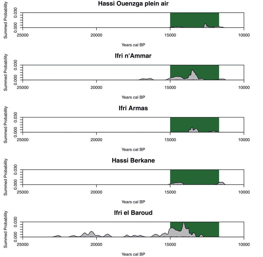
Quartär 66 (2019)                             T. Otto et al.

Fig. 3. Drill cores taken in Hassi Berkane.
Abb. 3. Bohrkerne aus Hassi Berkane.

208
Hassi Berkane and Late Iberomaurusian Land Use in the Eastern Rif, Morocco                                                        Quartär 66 (2019)

        Layer               Lab code 14C                  14
                                                               C Age              ±              14
                                                                                                      C Cal BP             ±            Material
     HAB-b9/1               COL3534.1.1                    10 033                59                   11 540             150            Charcoal
     HAB-b9/1               COL3535.1.1                   10 060                 54                   11 580             150            Charcoal
     HAB-b9/3               COL3536.1.1                    12 330                63                   14 370             180            Charcoal
     HAB-b9/3               COL3537.1.1                    12 521                64                   14 750             210            Charcoal
     HAB-b9/4               COL3538.1.1                   12 403                 63                   14 490             200            Charcoal
        Layer              Lab code U/Th            Age uncorrected               ±            Age corrected               ±            Material
       HAB-d                HAB-10-KK/6                    6 290                 170                  5 400              430           Flowstone

Fig. 4. Dating results from Hassi Berkane. AMS-14C dating was carried out by the CologneAMS (Centre for Accelerator Mass Spectrometry,
University of Cologne), U-series dating by the Institute of Geosciences, Johannes Gutenberg-Universität Mainz (Denis Scholz). 14C ages were
calibrated with CalPal and the CalPal-2007 Hulu calibration curve (Weninger & Jöris 2008).
Abb. 4. Datierungsergebnisse aus Hassi Berkane. AMS-14C-Datierung erfolgte im CologneAMS (Centre for Accelerator Mass Spectrometry,
Universität zu Köln), U/Th-Datierung im Institut für Geowissenschaften, Johannes Gutenberg-Universität Mainz (Denis Scholz). 14C-Alter wurden
kalibiert mit CalPal und der Calpal-2007 Hulu Kalibrationskurve (Weninger & Jöris 2008).

Fig. 5. Summed proability distributions of Iberomaurusian 14C-ages from the Eastern Rif. Calibrated with rcarbon (Bevan & Crema 2020) and the
Intcal13 calibration curve (Reimer et al. 2013). Marked in green is the age of the Late Iberomaurusian from Potì et al. (2019b).
Abb. 5. Kumulierte Wahrscheinlichkeitsverteilung der kalibrierten 14C-Alter des Ibéromaurusiens im östlichen Rif. Kalibriert mit rcarbon (Bevan & Crema,
2020) und der Intcal13 Kalibrationskurve (Reimer et al. 2013). Grün hervorgehoben ist das Alter des Späten Ibéromaurusiens nach Potì et al. (2019b).

                                                                                                                                                   209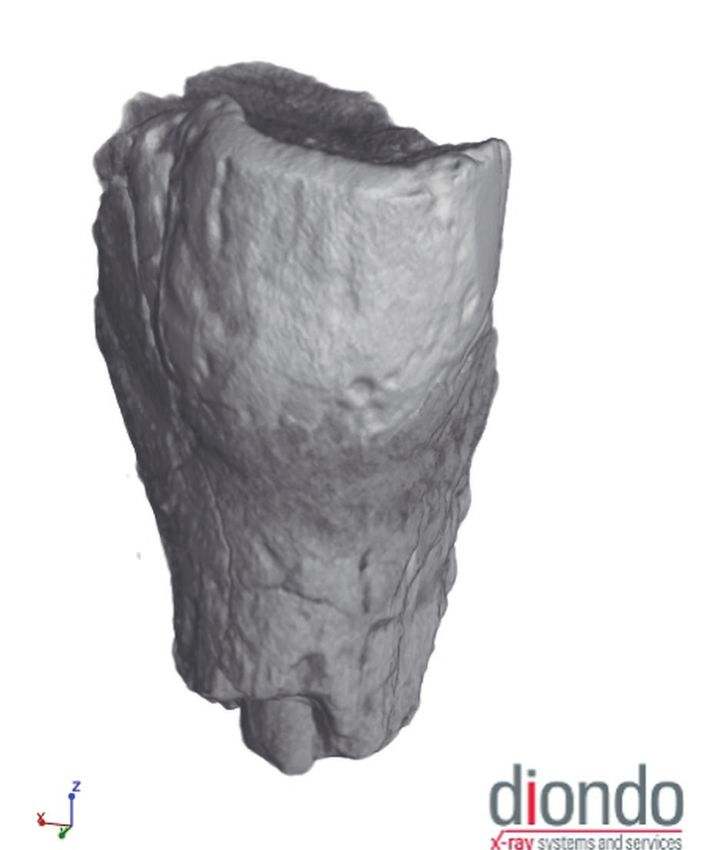
Quartär 66 (2019)                                                                                             T. Otto et al.

retouched into a segment (Tixier type 82; Fig. 6: 8), 12            A total of 144 pieces had remains of cortex, and 75
unretouched flakes, and 13 undiagnostic chips or                of these are either blades, bladelets, flakes or cores.
chunks. From the older, Iberomaurusian part of the              44 of these stem from the surface collections and four
sequence, 10 bladelets, two blades, six flakes, and 18          from the profile OW-W. The remaining 27 pieces
chunks were recovered. The bladelets were retouched             come from the drill-cores (two from HBE1, 25 from
into one La Mouillah point (Tixier type 62; Fig. 6: 2),         HBE2); of these, 11 date to the Epipalaeolithic
one pointed backed bladelet (Tixier type 51), one               occupation layer b9/1, and seven from the Late Ibero-
denticulated bladelet (Tixier type 77; Fig. 6: 5), and          maurusian layers b9/2 (n = 2), b9/3 (n = 2) and b9/5
one curved backed bladelet (Tixier type 56; Fig. 6: 3).         (n = 3). Seven of all 75 knapped pieces with cortex
One microburin was also found (Tixier type 102;                 were retouched into tools (two Ouchtata bladelets
Fig. 6: 7). Recovered without stratigraphic position            (Tixier type 71), two scrapers (type 1), one La Mouillah
were one bladelet, two flakes, and 10 chips or chunks.          point (type 62), one denticulated bladelet (type 77),
All lithics from these layers in HBE2 were made from            one backed bladelet (type 67), one final piece is a
Moulouya cherts, except three, for which the raw                microburin (type 102)) .
material attribution was not clear.                                 The materials for the lithic production were
     Other lithics from the escargotière without clearly        collected almost exclusively from the Moulouya river,
associated dates stem from HBE1 and the profile                 a secondary outcrop ca. 10 km away from the site that
OW-W. Three bladelets, one blade, and seven chunks              yields two different types of chert, both washed down
were found from the b8 sequence in HBE1: one                    the river from a currently unknown primary resource
Ouchtata bladelet (Tixier type 71; Fig. 6: 11) and one          (Nami 2007; Linstädter & Müller-Siegmund 2012). The
chunk from the transition zone between b8/5 and f5,             first variant is a coarse-grained, white-grayish material
along with four blades, one flake and six chips or              with a light brown to almost orange cortex (“Moulouya
chunks potentially from the b8 sequence or the a4               white”). The more common “Moulouya brown” is not
sequence. From the western Outer Wall profile                   only brown, but reddish, yellowish, even gray to black
OW-W, nine lithics were recorded: two blades, two               (Linstädter et al. 2012b; Götz 2016). All pieces have a
bladelets, one flake and four chunks. The flake was             rounded cortex attesting to their fluvial transport and
retouched into a simple scraper (Tixier type 1;                 are often battered. This material was also used in
Fig. 6: 13) and one bladelet into a denticulated bladelet       great quantities in neighboring sites such as Ifri
(Tixier type 77; Fig. 6: 4).                                    n’Ammar (Moser 2003) and Ifri el Baroud
     From the pre-Iberomaurusian layer f, only a few            (Potì et al. 2019b).
lithics were found, namely from HBE2 (layer f6). These              Only one artifact likely stems from a different
are two undiagnostic flakes and four chips/chunks.              source, from a primary outcrop near the town of Ain
     The material found on the surface of the site likely       Zora, 64 km away from the site (Nami 2007; Götz
stems from the escargotière, as small holes had been dug        2016). The black-brown material with a chalky cortex
in multiple places around the site, but lack associated         is not only available at the outcrop itself, but also
dates. From these areas, more blades were found than in         transported along wadis to the north into the Pleine du
the drill cores; the material from HBE1 and HBE2 is in          Guerrouaou as well as to the south, where it merges
general much smaller than the surface finds. One of the         with the Moulouya river channel. It is therefore
23 blades was retouched into a blade with Ouchtata              possible that this piece was also collected with the
retouch (Tixier type 71; Fig. 6: 10), while one of the six      others from the Moulouya and that the raw material
bladelets was retouched into a backed bladelet (Tixier          procurement was exclusively local.
type 67; Fig. 6: 1); here, another microburin was found             Few artifacts were made from limestone; the
(Fig. 6: 6). In this surface collection, 18 flakes were also    source of this material is currently unknown.
found, one as a simple scraper on flake (Tixier type 1;             In addition to the lithic artifacts, faunal remains
Fig. 6: 14). From the upper part of the site, on the hillside   were recorded throughout the drill cores (Fig. 3).
above the rock shelter, four bladelets were found (one          Malacofaunal remains were present in the sediments,
of which is a dihedral burin (Tixier type 27; Fig. 6: 9),       but not collected. Unfortunately, all remains are highly
along with four unretouched flakes and one chunk. Here          fragmented and undiagnostic, with the exception of
and in the area underneath the rock shelter, three cores        ostrich eggshells. Nine eggshell fragments were found
were found (Fig. 6: 15-17). These are small unidirectional      in stratigraphic position in HBE2, along with seven
bladelet cores and attest to on-site lithic production          further pieces from the same drill core without
following the scheme described by (Tixier 1963). No             recorded stratigraphic position (from layers b9/1 to
cores were found in the drill core sequences.                   b9/5). Found along with these, also lacking strati-
     Many artifacts show traces of thermal influence. 32        graphic information, was a human tooth, which could
of all 124 artifacts from the drill cores and the profile       originate from the Epipalaeolithic layer b9/1 or the
OW-W were heated and were found throughout the                  Late Iberomaurusian layers b9/2 to b9/5. The tooth
complete sequence. These traces are possibly linked to          was destroyed during 14C dating, but a CT-scan was
the omnipresence of fire documented in the form of              generated prior to dating (Fig. 7). Dating was, unfortu-
hearths and ash in the whole escargotière.                      nately, not possible due to the lack of sufficient organic

210
Hassi Berkane and Late Iberomaurusian Land Use in the Eastern Rif, Morocco Quartär 66 (2019)
Fig. 6. Lithic artifacts from Hassi Berkane. 1: Backed bladelet; 2: La Mouillah point; 3: Curved backed bladelet; 4-5: Denticulated
bladelet; 6-7: Microburin; 8: Segment; 9: Dihedral burin; 10-11: Ouchtata bladelet; 12: Pointed backed bladelet; 13-14: Simple scraper
on flake; 15-17: Bladelet core.
Abb. 6. Steinartefakte aus Hassi Berkane. 1: Rückengestumpfte stumpfwinklige Lamelle; 2: La Mouillah Spitze; 3: Rückengestumpfte
gebogene Lamelle; 4-5: Gezähnte Lamelle; 6-7: Kerbrest; 8: Segment; 9: Gemischter Mehrfachstichel; 10-11: Ouchtata Lamelle; 12: Spitze
Lamelle mit geradliniger Rückenstumpfung und retuschierter Basis; 13-14: Einfacher Kratzer an Abschlag; 15-17: Lamellenkern.
211Quartär 66 (2019) T. Otto et al.
material. This find is notable, as human remains are a Early Iberomaurusian, to Greenland Interstadial 1,
common appearance in Late Iberomaurusian assem- where prehistoric groups began the mass exploitation
blages of the Eastern Rif (Mikdad & Eiwanger 2000; of terrestrial gastropods (transition ca. 16-15 ka calBP)
Ben-Ncer 2004; Lorenz 2010; Humphrey et al. 2012). (Linstädter et al. 2012a; Potì et al. 2019b). Therefore,
Due to the minimally invasive nature of the field Hassi Berkane has the potential to tell us more about
work at Hassi Berkane, the assemblage size remains the very beginnings of this enigmatic phase, and may
small. However, the data available allows us to tenta- help us identify driving factors behind this subsistence
tively deduce that the inhabitants of Hassi Berkane shift.
utilized a bladelet-based industry typical of the Late
Upper Palaeolithic and Epipalaeolithic societies in the Analysis of land use and mobility of the
Eastern Rif (Tixier 1963). They likely collected their
Late Iberomaurusian in the Eastern Rif
raw materials from within a day’s walk from camp and
probably processed them directly at the site, as
multiple stages of tool production were identified In order to gain insight into land use and mobility
(cores, blanks, retouched tools) and many cortical patterns, we must contextualize this new site in the
pieces were found. Stark similarities between Late landscape, along with the other previously discovered
Iberomaurusian and Epipalaeoltihic lithic assemblages sites Ifri el Baroud, Ifri n’Ammar, Hassi Ouenzga plein
in the Eastern Rif (Linstädter et al. 2012a) along with air and Ifri Armas. This is done by analyzing site distri-
the lack of material clearly associated with the Late bution, settlement orientation in regard to resource
Neolithic date in Hassi Berkane make it impossible to locations, and mobility using lithic raw material data
attribute the material from the surface collections to from the assemblages, as described above. The first
one of the three identified occupation phases of this analysis, the Kernel Density Estimation, has a fairly
site. The chrono-cultural attribution can only be straightforward result. In figure 8, only low density
undertaken on the basis of radiometric age analyses values were recorded. The few sites are distributed
(Figs. 4 & 5). fairly evenly in the interior of the study area of the
Hassi Berkane represents an important site in the Eastern Rif, and no clear clusters can be identified.
Late Iberomaurusian and Epipalaeolithic settlement For the site catchment analyses, we first needed to
systems of the Eastern Rif. Interestingly, the Upper localize potential resources in the study area. We
Palaeolithic dates here show that settlement began focused on lithic and freshwater resources for the
just after the transition from the late phase of Heinrich current analysis, as the impact of faunal resources on
Event 1 (Fletcher et al. 2010), corresponding to the Iberomaurusian land use patterns is being analyzed in
an ongoing PhD dissertation. We incorporated the
two previously described lithic raw materials form the
Moulouya and from Ain Zora, and a third lithic variant,
called “Oumassine chert”. This reddish-yellow material
can also be collected in wadi channels in the Melilla
region in the North of the study area. Three additional
materials were mapped: “Zafrin radiolarite” and
“Ammorene” and “In-Narramine quartzites” (Jebb
2009; Gibaja et al. 2012). As these materials were not
recorded in Late Iberomaurusian assemblages, they
are not discussed further.
To model the potential fluvial distribution of the
cherts, we calculated the stream network model
(Fig. 9). Ain Zora chert potentially travels to the North
and to the South of the study area. The northern route
takes the material through the Pleine du Guerrouaou,
where Ifri el Baroud and Hassi Ouenzga plein air are
located, and along the river Oued Kert. The southern
transport route flows into the Moulouya, where it
would be mixed with the other colorful Moulouya
chert variants.
The flow accumulation model also helped identify
potential fresh water sources (Fig. 10). We marked the
rivers Oued Kert and Moulouya as potential water
Fig. 7. CT-scan of a human tooth from the drill core HBE2 from sources. Although it is unclear to which degree these
Hassi Berkane. were perennial rivers during the Late Iberomaurusian,
Abb. 7. CT-Scan eines menschlichen Zahns aus dem Bohrkern HBE2 there are some indicators that water was available in
von Hassi Berkane. these general areas in prehistoric times (Jebb 2009;
212Hassi Berkane and Late Iberomaurusian Land Use in the Eastern Rif, Morocco Quartär 66 (2019)
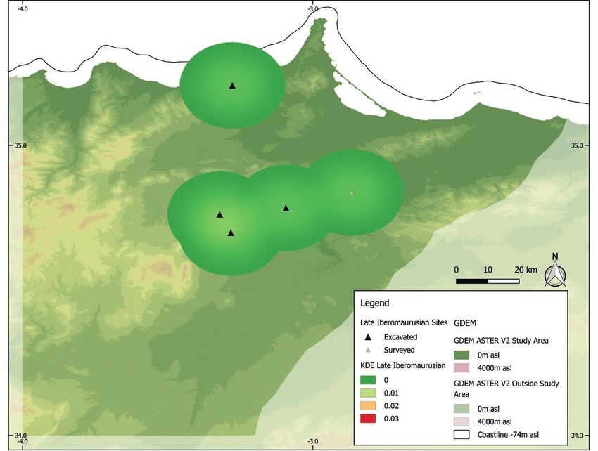
Fig. 8. Kernel Density Estimation of Late Iberomaurusian sites in the Eastern Rif. Digital Elevation Model from JPL 2009. Coastline at 74 m below
present sea level from Zickel et al. (2016).
Abb. 8. Kerndichteschätzung von Fundstellen des späten Ibéromaurusien im östlichen Rif. Digitales Geländemodell von JPL 2009. -74 m Isobathe von
Zickel et al. (2016).
Rixhon et al. 2017). In addition to these, we marked other two only slightly beyond. Interestingly, the sites
freshwater springs, such as the one at Hassi Berkane; are never situated immediately at the resources, but
another freshwater spring is located at the site of Hassi always some distance away. This is in contrast to later
Ouenzga, and two others are in the North of the study phases, as the Epipalaeolithic and Neolithic inhab-
area, at the sites Ammorene and In-Narramine (Jebb itants of the region opted to sit directly at their
2009). Finally, in the stream network model, we resources (Linstädter et al. 2012b; Otto 2018). These
observed a basin structure in the center of the study increased distances to lithic resources in the daily
area, in the Pleine du Guerrouaou; it is unclear if this range is notable, as well as the strong orientation
structure represents a stable lake that was available as towards fresh water. This result shows that fresh water
a water source throughout the Late Glacial, but the was likely a driving force behind settlement location
general topography of the area would encourage the choice, and that the Late Iberomaurusian groups were
collection of fresh-water reservoirs, and it is possible likely fairly mobile in their daily foraging activities.
that a resulting hydrological structure had the Daily foraging is only one type of mobility,
potential to influence prehistoric settlement patterns. however. The previous result tells us that the groups
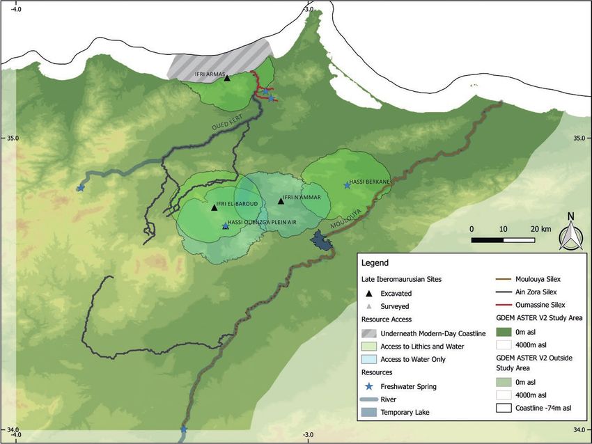
We began the site catchment analyses by overlaying chose settlement areas that were rather far away from
these resource locations with the 4h catchments we the closest resources, but not necessarily how far they
had calculated for each site (Fig. 11). We then color- were moving overall to collect their resources. To
coded each of these ranges according to the resources analyze this, we used data from the individual assem-
available in them, marking ranges with access to both blages. In each site, we counted the frequency with
freshwater and lithic resources in green, and resources which each lithic raw material was used during the Late
with only access to water in blue. It is notable that all Iberomaurusian and took this as a proxy for mobility
sites have access to water in their daily ranges. Lithic frequency (Fig. 12). Data from Ifri Armas could not be
resources are, in three of five cases, located near the used, as the complete sequence is mixed and it was not
edges of the daily ranges (but still inside), and in the possible to isolate the Late Iberomaurusian assemblage.
213Quartär 66 (2019) T. Otto et al.
Fig. 9. Location of surveyed and modeled lithic outcrops in the Eastern Rif. Digital Elevation Model from JPL 2009.
Abb. 9. Prospektierte und modellierte lithische Rohmaterialquellen im östlichen Rif. Digitales Geländemodell von JPL 2009.
For Ifri n’Ammar, we could only account for presence or darker-shaded areas, in the broadly triangular region
absence of Moulouya and Ain Zora cherts, as this data between Oued Kert, Ain Zora and the Moulouya. The
was not reported quantitatively in Moser (2003). From results from Ifri el Baroud show that Ain Zora chert,
Hassi Berkane, we only selected the stratified material available closest to the sites, was used most often, as well
dated to the Late Iberomaurusian. Only this site shows a as a notable amount of Moulouya cherts, located farther
clear preference for one type of raw material; Ifri el away. The inhabitants of Hassi Ouenzga plein air used
Baroud (Potì 2017) and Hassi Ouenzga plein air (J. both types with almost the same frequency, showing
Holzkämper, unpubl. data) used both Moulouya and that travels to the Moulouya were undertaken just as
Ain Zora cherts evenly, with some traces of Oumassine often as to the more local source. Hassi Berkane (HAB)
material. has the smallest procurement range, which is only slightly
By inputting this data into the site catchment analysis, smaller than its daily range; as the assemblage is relatively
we obtained a map of procurement ranges for each small, this can only be treated as a preliminary result.
Iberomaurusian site (Fig. 13). The size of each range The combined result of all analyses for the Late
corresponds to the closest collection point of each raw Iberomaurusian land use shows that the hunter-gatherer
material, and the shade and transparency of each range groups only very rarely moved toward the coast, likely
corresponds to the frequency with which the material linked to the use of Ifri Armas, and that most mobility
was used. The darker, more opaque areas were utilized was restricted to the hinterland, in a region large enough
more frequently than the lighter, translucent ones. The to be traversed in roughly a two-day’s walk. In contrast,
maximum procurement ranges of Ifri el Baroud (IB) and they were fairly mobile in their daily foraging activities,
Hassi Ouenzga plein air (HO_PA) are particularly large, as sites are never situated directly at the resources they
but these represent only trace quantities of Oumassine used. The general land use pattern can be characterized
chert found in the assemblages. Most of the raw material as a homogeneous, somewhat mobile exploitation of a
procurement from these sites is restricted to the small, suitable habitat.
214Hassi Berkane and Late Iberomaurusian Land Use in the Eastern Rif, Morocco Quartär 66 (2019)
Fig. 10. Location of surveyed and modeled fresh water sources in the Eastern Rif. Digital Elevation Model from JPL 2009.
Abb. 10. Prospektierte und modellierte Süßwasserquellen im östlichen Rif. Digitales Geländemodell von JPL 2009.
Discussion settlement of the South of the Iberian Peninsula:
Heinrich Event 1 seems to have significantly impacted
Hassi Berkane is unique in the observation that the hunter-gatherer groups in Southern Iberia, so that
assemblage yielded mainly lithics from the Moulouya they were not able to bounce back during GI1, when
river, as opposed to materials from both the Moulouya the climate got better. In Morocco, on the other hand,
and Ain Zora. Due to the small sample size, it is difficult we see an increase in sites and the mass consumption
to interpret this observation further. In general, the of terrestrial gastropods during GI1. Such observa-
resource use pattern at this site is similar to that from tions by various authors agree to a large extent that a
neighboring sites, with a focus on more local raw change in land use becomes visible in the late Ibero-
materials and only rare long-distance movements. maurusian, which may be associated with environ-
This aligns nicely to the pattern previously observed mental change or reflect a particular new form of
by Potì et al. (2019b), who highlight the shift toward resource exploitation. An increase in habitat suitability
the exploitation of local raw materials (Ain Zora) in the can go hand-in-hand with a decrease in mobility and
Late Iberomaurusian as opposed to the utilization of an increase in resource predictability (Dyson-Hudson
the more distant Moulouya cherts in the Early & Smith 1978; Stein Mandryk 1993). Therefore, the
Iberomaurusian. links between climate, mobility, dietary breadth, and
Other authors hypothesize that habitat suitability resource predictability need to be examined further,
and sedentary behavior might have increased during in order to better understand the dynamics behind
the Late Iberomaurusian after Heinrich Event 1 the Late Iberomaurusian land use patterns. Especially
(Humphrey et al. 2014; Morales 2018). Barton et al. the predictability of utilized faunal resources – not
(2013) link this to an increase in precipitation and only terrestrial gastropods, but also large and small
dietary breadth, reflected by (not only) the game – needs to be incorporated into the discussion.
exploitat ion of land snails (Taylor et al. 2011). Weniger We can hypothesize that there is a connection
et al. (2019) show that the Moroccan settlement of the between the land use pattern a group employed and
Late Glacial is more stable than the contemporary the faunal resources they exploited, such as a link
215Quartär 66 (2019) T. Otto et al.
Fig. 11. Daily range of Late Iberomaurusian sites in the Eastern Rif. Digital Elevation Model from JPL 2009. Coastline at 74 m below present
sea level from Zickel et al. (2016).
Abb. 11. Tägliches Schweifgebiet von Fundstellen des späten Ibéromaurusien im östlichen Rif. Digitales Geländemodell von JPL 2009. 74 m
Isobathe von Zickel et al. (2016).
between a fairly immobile society and a staple resource those in the Eastern Rif. Examining these dynamics more
that also is not assumed to be fairly mobile (Linstädter closely may help us identify driving factors behind the
2014). A particularly challenging question is whether inclusion of snails into the subsistence pattern as well as
the increased habitat suitability implied by these results its impact on land use patterns and long-term settlement
derives from climate conditions or from a conscious stability. The Iberomaurusian in Morocco therefore
resource selection which included gastropods, which is offers one of the rare opportunities in the Palaeolithic
not observed for contemporaneous groups in Southern record to understand the interrelationships of cultural
Iberia, who were living in similar climate conditions to and environmental change more deeply.
Ain Zora Moulouya Oumassine Silex unspec. Other
Ifri n’Ammar + + - + +
Ifri el Baroud 4 428 (48.4 %) 3 951 (43.2 %) 14 (0.2 %) 71 (0.8 %) 693 (7.6 %)
Hassi Berkane - 36 (94.7 %) - 2 (5.3 %) -
Hassi Ouenzga plein air C3/C4 553 (50.8 %) 531 (48.8 %) 1 (0.1 %) - 4 (0.4 %)
Hassi Ouenzga plein air C5 94 (46.3 %) 107 (52.7 %) 1 (0.5 %) 1 (0.5 %) -
Fig. 12. Lithic raw materials used in Late Iberomaurusian sites in the Eastern Rif.
Abb. 12. In Fundstellen des späten Ibéromaurusien im östlichen Rif verwendete lithische Rohmaterialien
216Sie können auch lesen