OLYMP Expeditionswetter - Vorhersage - ZAMG
←
→
Transkription von Seiteninhalten
Wenn Ihr Browser die Seite nicht korrekt rendert, bitte, lesen Sie den Inhalt der Seite unten
ZENTRALANSTALT für METEOROLOGIE und GEODYNAMIK
KUNDENSERVICE Tirol & Vorarlberg – Wetterdienst Innsbruck
Fürstenweg 180, A-6020 Innsbruck
+43 512 285598 · expeditionswetter@zamg.ac.at

                                                · · · English version below · · ·

                             Expeditionswetter – Vorhersage
                                                              für
                                                       OLYMP

                         Individuelle Informationen zur Prognose für OLYMP
        geogr. Breite 40,09° (N...positive Werte, S...negative Werte)
        geogr. Länge 22,36° (O...positive Werte, W...negative Werte)
        Seehöhen für Temperatur- und Feuchte-Prognosen 1500 m, 2200 m, 3000 m
        Seehöhe für Wind-Prognosen 3000 m
        Zeitverschiebung Lokalzeit in Griechenland ist UTC +2 h.
        Weblink Alle Infos und Prognosen finden sich hier:
             LINK
        Zeitpunkt . . . der täglichen Aktualisierung des Weblinks und Bereitstellung der Prognosen:
             ca. 10:00 Uhr Lokalzeit in Griechenland.
        Ende des Bestellzeitraums 2018-03-20 (Jahr-Monat-Tag)

                                           Allgemeine Informationen
        - Oben genannter Link wird täglich aktualisiert. Dort finden sich alle im Rahmen des ZAMG Expeditions-
             wetter-Services zusammenstellten Informationen. Die SMS werden täglich erstellt, aus diversen
             Gründen kann es beim Versand aber zu Problemen kommen, auf die die ZAMG keinen Einfluss
             hat. Die Expeditionen werden in diesen Fällen ersucht, den manuellen Versand der SMS selbst
             zu organisieren: Eine Verbindungsperson mit Internetzugang kopiert hierzu täglich die beiden
             SMS Texte (als Textdateien im obigen Link zu finden) und fügt diese im Messaging-Dienst des
             Satphone-Providers ein, z.B. messaging.iridium.com oder inmarsat.com/sms.

        - Koordinaten und Höhen können von den tatsächlichen Werten des Expeditionsziels geringfügig abwei-
             chen. Der Grund dafür ist eine bewusste, bestmögliche Anpassung der Daten des Wettermodells
             an die Wirklichkeit.
        - Alle Zeiten im SMS und im Meteogramm (x-Achse) beziehen sich auf oben genannte Lokalzeit.
              Zeitverschiebungen werden auf ganze Stunden gerundet.

        - Rückfragen und optionale telefonische Wetterberatungen sind während des Bestellzeitraums unter
              +43 512 285598 - DW wird bei Bestellung bekanntgegeben - möglich. Die optionalen telefo-
              nischen Beratungen sind im Basispreis nicht inbegriffen. Kosten und Ablauf siehe Bestellformular.

        © ZAMG                                                                                 www.zamg.ac.at
ZENTRALANSTALT für METEOROLOGIE und GEODYNAMIK
KUNDENSERVICE Tirol & Vorarlberg – Wetterdienst Innsbruck
Fürstenweg 180, A-6020 Innsbruck
+43 512 285598 · expeditionswetter@zamg.ac.at
BENUTZERANLEITUNG
6-Tages – SMS-Vorhersage
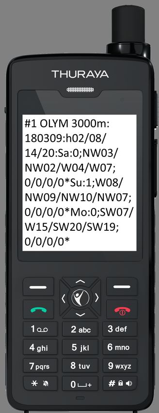
#1 Mit #1 beginnt das erste SMS, welches die
Tage eins bis drei beeinhaltet. Das zwei-
te SMS #2 enthält dann die Tage vier bis
sechs.
OLYM 3000m: Kürzel des Expeditionsziels und
die Seehöhe auf die sich die folgenden
Temperatur- und Wind-Prognosen beziehen.
180309: Prognose vom 09.03.2018
h02/08/14/20: Die folgenden Werte gelten an
den jeweiligen Tagen für diese vier Uhrzeiten
(02:00, 08:00, 14:00 und 20:00 Uhr), und
zwar in Lokalzeit des Expeditionsziels!
Sa: Englische Bezeichnung des Wochentags für
den die Prognose gilt, hier: Sa = Saturday
= Samstag.
0; Erwartete Tagesmittel-Temperatur in °C auf
Höhe des Expeditionsziels (= höchste der
oben genannten drei Prognose-Seehöhen),
hier: 3000 m.
NW03/NW02/W04/W07; Prognostizierte
mittlere Windrichtung und Windgeschwin-
digkeit auf Höhe des Expeditionsziels in m/s
zu den obigen vier Zeiten des jeweiligen
Tages. Im Beispiel ist für Samstag 02:00
Uhr nachts Nordwestwind mit 3 m/s und
um 14:00 Uhr nachmittags Westwind mit
4 m/s vorhergesagt. (Ost wird mit E wie
East“ abgekürzt, 0 bedeutet null“.)
” ”
0/0/0/0 Prognostizierte Niederschlagsmengen in
Liter/m2 bzw. Millimeter (mm) während der
6 Stunden vor dem jeweiligen Zeitpunkt. In
diesem Beispiel ist an allen drei Tagen kein
Niederschlag zu erwarten.
* beendet den Prognosetag.
© ZAMG www.zamg.ac.at
ZENTRALANSTALT für METEOROLOGIE und GEODYNAMIK
KUNDENSERVICE Tirol & Vorarlberg – Wetterdienst Innsbruck
Fürstenweg 180, A-6020 Innsbruck
+43 512 285598 · expeditionswetter@zamg.ac.at
ZAMG − Weatherforecast for
Olymp (Lat=40.09°,Lon=22.36°)
All time values correspond to localtime in Griechenland.
(Forecast Date and Time: Friday, 2018−03−09 00 UTC)
BENUTZERANLEITUNG
daylight
12 7-Tages – Meteogramme
10 1500 m
8 2200 m
3000 m
Temperature [C]
6
4 Tag und Uhrzeit . . . sind immer in
2 Lokalzeit des Expeditionsziels.
0
−2
Gelb unterlegt ist die Zeit mit
−4 Tageslicht.
−6
−8
Temperature Vorhersage der Luft-
−10 temperatur in °C für 3 relevan-
Fri Fri Sat Sat Sun Sun Mon Mon Tue Tue Wed Wed Thu Thu Fri te Höhen in der freien Atmo-
00h 12h 00h 12h 00h 12h 00h 12h 00h 12h 00h 12h 00h 12h 00h
sphäre.
100
1500 m Relative Humidity Vorhersage der
2200 m relative Luftfeuchtigkeit in %
Relative Humidity [%]
80 3000 m
für 3 relevante Höhen in der
60 freien Atmosphäre. Über 80-
90%: Wolken/Nebel in die-
40 ser Höhe wahrscheinlich; unter
50% bedeutet trockene Luft.
20
Windpfeile Vorhersage der Wind-
0 richtung, z.B. ↓ = Wind aus
Fri Fri Sat Sat Sun Sun Mon Mon Tue Tue Wed Wed Thu Thu Fri
00h 12h 00h 12h 00h 12h 00h 12h 00h 12h 00h 12h 00h 12h 00h Nord, → = Wind aus West.
Mean Windspeed Vorhersage der
mittleren Windgeschwindig-
Mean Windspeed [km/h]
80 keit in km/h in der freien
70 3000 m Atmosphäre auf angegebener
60
50 Seehöhe. Die lokale Wind-
40 geschwindigkeit wird aber
30 stark durch die Topographie
20
10 modifiziert.
0
Fri Fri Sat Sat Sun Sun Mon Mon Tue Tue Wed Wed Thu Thu Fri Precipitation Vorhersage der Nie-
00h 12h 00h 12h 00h 12h 00h 12h 00h 12h 00h 12h 00h 12h 00h derschlagsmenge in mm; bei
20 8 Schnee: 10 mm entsprechen je
Precipitation 7
Cloudiness [Octas]
Precipitation [mm]
15 Cloudiness 6
nach Temperatur und Wind 5
5 bis 30 cm Neuschnee.
10 4
Cloudiness Vorhersage des Bewöl-
3
5 2 kungsgrads in Achteln: 0 =
1 wolkenlos, 8 = bedeckt. Keine
0 0 Aussage über das Höhenlevel
Fri Fri Sat Sat Sun Sun Mon Mon Tue Tue Wed Wed Thu Thu Fri
00h 12h 00h 12h 00h 12h 00h 12h 00h 12h 00h 12h 00h 12h 00h der Wolken — dafür ist die re-
Copyright ZAMG − no redistribution allowed lative Feuchte ein Indikator.
© ZAMG www.zamg.ac.atZENTRALANSTALT für METEOROLOGIE und GEODYNAMIK
KUNDENSERVICE Tirol & Vorarlberg – Wetterdienst Innsbruck
Fürstenweg 180, A-6020 Innsbruck
+43 512 285598 · expeditionswetter@zamg.ac.at
INTERPRETATIONSHILFE
für
SMS und Meteogramme
Windgeschwindigkeit Die angegebenen Prognosen der mittleren Windgeschwindigkeit entsprechen
Werten für die freie Atmosphäre, und zwar in etwa auf der Höhe des Gipfels bzw. Expeditionsziels.
Für freistehende Berge oder ebene Bereiche (→ Polar- oder Wüsten-Expeditionen) stimmen die
Prognose-Werte meist sehr gut mit der Wirklichkeit überein. Für weniger markante Berge inmitten
von Gebirgen, Tallagen oder Pässe (→ Trekkingtouren) sind die Prognosen weniger genau. Böen
können 1.5- bis 2-fache Stärke des mittleren Windes erreichen.
Umrechnung von m/s in km/h Im Meteogramm sind die Windgeschwindigkeiten in km/h angege-
ben, im SMS aus Platzgründen in m/s. Es gilt 1 m/s = 3.6 km/h. Als Faustregel können die
Werte des SMS ×4 genommen werden und man bekommt eine Abschätzung für die Windge-
schwindigkeit in km/h.
Niederschlagsmenge Die Niederschlagsmenge wird im Meteogramm und im SMS in Millimeter (mm)
angegeben. 1 mm entspricht einem Liter pro Quadratmeter (l/m2 ). Es handelt sich immer um
Prognosen der 6-stündigen Niederschlagsmenge, also der Regen- oder Schneemenge, die in den
6 Stunden vor der angegebenen Zeit zu erwarten ist.
Schneefallgrenze Im Meteogramm können die Temperaturen in den verschiedenen Seehöhen eine
grobe Abschätzung der Schneefallgrenze ermöglichen. Darüber fällt der vorhergesagte Nieder-
schlag als Schnee oder Graupel. Im SMS steht die Tagesmitteltemperatur auf Höhe des Gipfels
oder Expeditionsziels zur Verfügung. Die Schneefallgrenze kann daher auch ohne Meteogramm
mithilfe des SMS zumindest ungefähr abgeschätzt werden.
Schneemenge Zur Abschätzung der 6-stündigen Neuschneehöhe dient folgende Faustregel: 10 mm
Niederschlag gibt ca. 5 cm (nassen) bis ca. 30 cm (trockenen, sehr lockeren) Neuschnee.
Wolken Der im Meteogramm angezeigte Bewölkungsgrad sagt nichts über das Höhenniveau der Wol-
ken aus. Er entspricht einer Summe aus tiefen Wolken“ (z.B. Nebelhauben um die Berge oder
”
Hochnebel in Tälern), mittelhohen Wolken“ (z.B. diffuse Schichtwolken über den Gipfeln oder
”
Nebel um höhere Berge) und hohen Wolken“ (z.B. Cirrus–Schleierwolken weit über den Gip-
”
feln). Die Prognose der relativen Feuchte kann ein Indikator für die Höhenniveaus der Wolken
sein: Sind z.B. 7-8 Achtel Bewölkung vorhergesagt (stark bewölkt bis bedeckt) und trotzdem ist
die relative Feuchte in allen angegebenen Höhen gering (unter 40-50%), dann könnte das ein
Hinweis sein, dass es sich nur um Wolken über den Gipfeln handelt. In diesem Beispiel gäbe es
demnach eventuell diffuses Licht, aber eher keinen Nebel.
Wettercharakter im SMS Im SMS fehlt aus Platzgründen die Angabe des Bewölkungsgrads. Die
6-stündige Niederschlagsmenge kann jedoch häufig gut zur Vorhersage des Wettercharakters
verwendet werden. Insbesondere wenn man im Laufe der Expedition (z.B. schon am Weg ins Ba-
sislager) die vorhergesagte Niederschlagsmenge mit dem tatsächlichen Wettercharakter vergleicht
und sozusagen lernt, wie sich das Wettermodell verhält.
Ein Beispiel: Niederschlagsmengen von 0 mm können wolkenlosen Himmel bedeuten, geringe
Mengen von 0.1 bis 0.5 mm zusehends trübere Verhältnisse, und erst ab einer höheren 6-stündigen
Niederschlagsmenge regnet, schneit oder graupelt es tatsächlich mit nennenswerter Intensität.
© ZAMG www.zamg.ac.atZENTRALANSTALT für METEOROLOGIE und GEODYNAMIK
KUNDENSERVICE Tirol & Vorarlberg – Wetterdienst Innsbruck
Fürstenweg 180, A-6020 Innsbruck
+43 512 285598 · expeditionswetter@zamg.ac.at
· · · deutsche Version siehe oben · · ·
Expeditionweather – Forecast
for
OLYMP
Individual informations on the forecast for OLYMP
latitude 40,09° (N...positive values, S...negative values)
longitude 22,36° (E...positive values, W...negative values)
altitudes for temperature and humidity forecasts 1500 m, 2200 m, 3000 m
altitude for wind forecasts 3000 m
time difference Local time in Greece is UTC +2 h.
weblink All infos and forecasts can be found here:
LINK
daily update . . . of weblink and provision of daily forecast:
ca. 10:00 local time in Greece.
end of the service 2018-03-20 (year-month-day)
General informations
- Above-mentioned weblink is updated daily. It provides all ZAMG expeditionweather informations and
forecasts. The SMS are created daily. Still, various problems can occur during the transmission
to satellite phones, which are beyond ZAMG’s scope. In these cases expeditions are requested
to organize SMS transmission on their own: A contact person with access to internet copies the
SMS texts (text-files at mentioned link) and paste them at the messaging service of the satphone
provider, e.g. messaging.iridium.com oder inmarsat.com/sms.
- Coordinates and altitude levels might differ slightly from actual values of expedition goal due to
difference between the weather model and the real world.
- All time values of the SMS and the meteogram (x-axis) correspond to local time mentioned above.
Time difference is rounded to full hours.
- Any queries and optional telephonic weather briefings can be made under +43 512 285598 - DDI
is announced when order is confirmed. The optional briefings per phone are not included in
the base order. Details on costs and procedures can be found on the order sheet.
© ZAMG www.zamg.ac.atZENTRALANSTALT für METEOROLOGIE und GEODYNAMIK
KUNDENSERVICE Tirol & Vorarlberg – Wetterdienst Innsbruck
Fürstenweg 180, A-6020 Innsbruck
+43 512 285598 · expeditionswetter@zamg.ac.at
USER GUIDE
6-day – SMS-Forecast
#1 beginning with #1 the first SMS contains the
first three days, #2 is the head of the second
SMS containing day four to six.
OLYM 3000m: Abbreviation for the expedition
goal and altitude for which the following
temperature und wind forecasts are valid.
180309: Forecast issued on March, 09th 2018
h02/08/14/20: The following forecast values are
valid at these four times of the respective
days (02:00, 08:00, 14:00, and 20:00). All
time values are in local time at the expedi-
tion goal!
Sa: Weekday for which the forecast is valid, here:
Sa = Saturday.
0; Expected daily mean temperature in °C at the
altitude of the expedition goal (= highest of
the above-mentioned forecast altitudes, he-
re: 3000 m).
NW03/NW02/W04/W07; Forecasted mean
wind speed and wind direction at the al-
titude of the expedition goal in m/s at the
above-mentioned four times of the respecti-
ve day. In this example, a 3 m/s wind from
Northwest is predicted on Saturday 02:00
(a.m.). At 14:00 (2:00 p.m.) winds from
West at 4 m/s are expected.
0/0/0/0 Expected precipitation in liter/m2 or
millimeter (mm), respectively, during the
preceding 6 hours of the respective time of
day. In this example no precitipation is fore-
casted.
* ends the forecast day.
© ZAMG www.zamg.ac.atZENTRALANSTALT für METEOROLOGIE und GEODYNAMIK
KUNDENSERVICE Tirol & Vorarlberg – Wetterdienst Innsbruck
Fürstenweg 180, A-6020 Innsbruck
+43 512 285598 · expeditionswetter@zamg.ac.at
ZAMG − Weatherforecast for
USER GUIDE
Olymp (Lat=40.09°,Lon=22.36°) 7-day – Meteograms
All time values correspond to localtime in Griechenland.
(Forecast Date and Time: Friday, 2018−03−09 00 UTC)
daylight
12 Days and times . . . are always in
10 1500 m
2200 m local time at the expedition
8
3000 m goal. Yellow shaded areas fra-
Temperature [C]
6
4 me the time window with day-
2 light.
0
−2 Temperature Forecast of the air
−4 temperature of the free atmo-
−6 sphere in °C at 3 relevant alti-
−8
−10 tudes.
Fri Fri Sat Sat Sun Sun Mon Mon Tue Tue Wed Wed Thu Thu Fri
00h 12h 00h 12h 00h 12h 00h 12h 00h 12h 00h 12h 00h 12h 00h Relative Humidity Forecast of rela-
tive humidity of the free at-
100
1500 m
mosphere in % at 3 rele-
2200 m vant altitudes. Above 80-90%
Relative Humidity [%]
80 3000 m
clouds/fog is likely at this
60 height; below 50% means dry
air.
40
Wind arrows Forecast of wind di-
20
rection, e.g. ↓ = wind from
North, → = wind from West.
0 Mean Windspeed Forecast of the
Fri Fri Sat Sat Sun Sun Mon Mon Tue Tue Wed Wed Thu Thu Fri
00h 12h 00h 12h 00h 12h 00h 12h 00h 12h 00h 12h 00h 12h 00h mean wind speed in free at-
mosphere in km/h at the gi-
ven altitude. Local wind speed
is strongly modified by topo-
Mean Windspeed [km/h]
80
70 3000 m graphy (windward or leeward
60 side, canalization effects,. . . ).
50
40 Gusts can be 1.5- to 2-
30 times stronger than mean wind
20
10 speed.
0
Fri Fri Sat Sat Sun Sun Mon Mon Tue Tue Wed Wed Thu Thu Fri Precipitation Forecast of precipita-
00h 12h 00h 12h 00h 12h 00h 12h 00h 12h 00h 12h 00h 12h 00h tion in mm; in case of snow:
20 8 10 mm correspond to of fresh
Precipitation 7
Cloudiness [Octas]
Precipitation [mm]
Cloudiness snow, depending on tempera-
15 6
5 ture and wind 5-30 cm.
10 4 Cloudiness Forecast in eights: 0 =
3
5 2
clear sky, 8 = overcast. No in-
1 formation about height level of
0 0 clouds – relative humidity can
Fri Fri Sat Sat Sun Sun Mon Mon Tue Tue Wed Wed Thu Thu Fri
00h 12h 00h 12h 00h 12h 00h 12h 00h 12h 00h 12h 00h 12h 00h be an indicator of cloud heigth
Copyright ZAMG − no redistribution allowed
level.
© ZAMG www.zamg.ac.atZENTRALANSTALT für METEOROLOGIE und GEODYNAMIK
KUNDENSERVICE Tirol & Vorarlberg – Wetterdienst Innsbruck
Fürstenweg 180, A-6020 Innsbruck
+43 512 285598 · expeditionswetter@zamg.ac.at
AID TO INTERPRETATION
for
SMS and Meteograms
Windspeed The forecasts of mean windspeed represent the values in the free atmosphere at summit
height or the height of the expedition’s target. These prognostic values match very good with
reality for freestanding mountains or great plains (→ polar- or desert-expeditions). For less ex-
posed mountains centered in mountain ranges, as well as for valleys or passes the forecasts are
less precise. Gusts can be 1.5 to 2-times higher than mean windspeeds.
Conversion from m/s to km/h In meteograms the windspeed is specified in km/h. In SMS forecasts
ist is provided in m/s due to reasons of space. 1 m/s = 3.6 km/h. As a rough estimation the
values from the SMS can be taken ×4 to get the approximate windspeed in km/h.
Precipitation The precipitation amount is given in millimeters (mm). 1 mm is equal to 1 liter per
squaremeter (l/m2 ). It is always a prognosis of the 6-hourly precipitation amount, i.d. the rain
or snowfall amount to be estimated during the 6 hours before the given time.
Snowfall limit In the meteogram the temperatures in different altitudes allow an evaluation of the
snowfall limit. In the SMS the temperature at summit height is given. This way the snowfall limit
can be roughly evaluated also with the information out of the SMS without meteogram.
Snow height As a rule of thumb to estimate the 6-hourly fresh snow height: 10 mm precipitation
mean about 5 cm (wet) to 30 cm (dry, very loose) fresh snow.
Clouds The cloudage given in the meteogram doesn’t contain any information about the height level
of the clouds. It is equal to a sum of “low clouds” (e.g. fog around mountains or clouds in valleys),
“middle clouds” (e.g. diffuse stratus clouds above summits or as fog around higher mountains)
and “high clouds” (cirrus clouds way above the summits). The forecast of relative humidity can
be an indicator for the height levels of clouds: If 7/8 cloudage is forecasted but the relative
humidity in all levels is low, it could be high clouds above the summit only. Diffuse light can be
expected but no fog.
Weather charakter in SMS Due to reasons of space no forecast for cloudage is given in SMS. But
the precipitation forecast can be taken to evaluate the estimated weather character. Comparing
the forecasted precipitation amount with the real weather character during the expedition (e.g.
while reaching base camp) can be very useful to learn about the behaviour of the weather model.
An example: Precipitation amounts of 0 mm can stand for clear sky, small amounts between
0.1 and 0.5 mm can mean more and more cloudy conditions and only with higher 6-hourly
precipitation amounts it rains or snows with considerable intensity.
© ZAMG www.zamg.ac.atSie können auch lesen