Polarstern EXPEDITION PROGRAMME PS128 - PS128 Cape Town - Cape Town 6 January 2022 - 28 February 2022 - EPIC
←
→
Transkription von Seiteninhalten
Wenn Ihr Browser die Seite nicht korrekt rendert, bitte, lesen Sie den Inhalt der Seite unten
EXPEDITION PROGRAMME PS128

Polarstern
PS128
Cape Town – Cape Town
6 January 2022 – 28 February 2022

Coordinator:			Ingo Schewe

Chief Scientist:		Ralf Tiedemann
Bremerhaven, November 2021

Alfred-Wegener-Institut
Helmholtz-Zentrum
für Polar- und Meeresforschung
Am Handelshafen 12
D-27570 Bremerhaven

Telefon:    +49 471 4831-0
Telefax:    +49 471 4831-1149
E-Mail:		   info@awi.de

Website:			http://www.awi.de
Email Coordinator:		    ingo.schewe@awi.de
Email Chief Scientists: ralf.tiedemann@awi.de
The Expedition Programme Polarstern is issued by the Alfred
Wegener Institute, Helmholtz Centre for Polar and Marine
Research (AWI) in Bremerhaven, Germany.

The Programme provides information about the planned goals and
scientific work programmes of expeditions of the German
research vessel Polarstern.
The papers contained in the Expedition Programme Polarstern do
not necessarily reflect the opinion of the AWI.

Editorial editing and layout
Susan Amir Sawadkuhi

Alfred-Wegener-Institut
Helmholtz-Zentrum für Polar- und Meeresforschung
Am Handelshafen 12
27570 Bremerhaven
Germany

www.awi.de
www.awi.de/en/reports
PS128

      6 January – 28 February 2022
         Cape Town – Cape Town

                  EASI-1
East Antarctic Ice Sheet Instabilities (1) –
     Ice-Ocean-Climate Interactions

             Chief scientist
             Ralf Tiedemann

                Coordinator
               Ingo Schewe
Contents
1. Überblick und Fahrtverlauf 2
Summary and Itinerary 4
2. Marine Geology and Paleoceanograph 5
3. Bathymetry of the East Antarctic Sea 10
4. Marine Geophysics/Parasound 12
4.1 The continental-marine seismic link
of Dronning Maud Land: Reconstructing
the long-term evolution of the Ekström ice streams 12
4.2 Parasound: Sub-bottom profiling
in the Indian Ocean sector of the Southern Ocean
and along the Antarctic continental margin 14
5. Marine Geochemistry: Water Column, Bottom Water and
Sedimentary Porewater Analyses 16
6. Continental Geology and Geodesy 21
6.1. Late Quaternary deglaciation and climate history
of Thala Hills, Enderby Land 21
6.2. Interaction between mass changes
of the Antarctic ice sheet and solid Earth in East Antarctica 24
Appendix
A.1 Beteiligte Institute / Participating Institutes 28
A.2 Fahrtteilnehmer / Participants 31
A.3 Schiffsbesatzung / Ship’s Crew 33
11. ÜBERBLICK UND FAHRTVERLAUF
Ralf Tiedemann1, Juliane Müller1 1
DE.AWI
Die Polarstern-Expedition PS128 unter dem Titel „East Antarctic Ice Sheet Instability (EASI-1)“
ist die erste von drei geplanten Expeditionen, die sich mit der erdgeschichtlichen Instabilität des
ostantarktischen Eisschildes (EAIS) und seinen Wechselwirkungen mit Zirkulationsänderungen
im Südpolarmeer befasst. Die Reaktion des EAIS auf die anthropogene Erwärmung ist mit
großen Unsicherheiten für die Vorhersage des zukünftigen Meeresspiegelanstiegs behaftet,
weil die Eis-Ozean-Klima-Rückkopplungen kaum verstanden sind. Ihre Rekonstruktion,
insbesondere für Zeiten in denen es wärmer war als heute, soll helfen, die Grundlagen für die
Vorhersage zukünftiger Änderungen zu verbessern. Unsere Arbeiten konzentrieren sich auf
den antarktischen Kontinentalabhang und die Küstenregion zwischen dem Weddellmeer und
der Kooperationssee. Ziel ist die Gewinnung von marinen und terrestrischen Sedimentkernen
und die Erfassung von ozeanographischen, marin-geophysikalischen und kontinental-
geodätischen Daten. Damit wollen wir neue Erkenntnisse über die Änderungen in folgenden
Bereichen gewinnen: Bildung von Antarktischem Bodenwasser vor Cape Darnley, ozeanischer
Wärmetransport unter das Eisschelf der Neumayer-Station III, Verhalten der Eisaufsetzlinie,
Meereisbedeckung, Schmelzwassereintrag und ozeanische Stratifizierung. Die Gewinnung
langer Sedimentkerne und -oberflächen wird von bathymetrischen Kartierungen, sediment-
echografischen und hydrografischen Untersuchungen (inkl. Wasser- und Planktonproben)
begleitet. Die über Vibroseismik vermessenen Sedimentstrukturen unterhalb des Ekström-
Schelfeises werden über den Kontinentalschelf mit marin-seismischen Profilen kartiert, um die
präglazialen und glazialen Sedimentationsprozesse zu quantifizieren.
Die Expedition trägt zu den Zielen der Programmorientierten Förderung (PoF) der Helmholtz-
Gemeinschaft, dem Forschungsprogramm "Erde im Wandel – Unsere Zukunft sichern" bei.
Die Ziele unserer Expedition stehen im engem Zusammenhang mit diesem Programm,
insbesondere mit dem Thema "Ozean und Kryosphäre im Klima". Dieses Thema wird die
Ursachen, Mechanismen und Folgen von "Meeresspiegelveränderungen", "Erwärmung des
Klimas" und "Klimavariabilität und -extreme" auf der Grundlage eines kombinierten Ansatzes
von Beobachtungen, Rekonstruktionen (modern und paläo) und Erdsystemmodellierung
untersuchen.
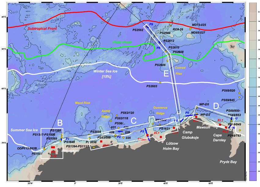
Der Fahrtabschnitt PS128 wird am 6. Januar 2022 in Kapstadt starten und am 28. Februar
2022 in Kapstadt enden. Bereits auf dem Transit Richtung Antarktis befindet sich das erste
Untersuchungsgebiet (E) zwischen DelCano Rücken / Conrad Rücken und dem Antarktischen
Kontinentalhang vor Enderbyland (Abb. 1). Am 13/14. Januar wird unsere Landgruppe für
ihre 2-wöchigen Feldarbeiten in der Region der Molodeshny Oase an der belarussischen
Station Gora Vechernyaya abgesetzt (Camp Glubokoje). Währenddessen werden die
marinen Arbeiten am Kontinentalhang vor Cape Darnley in enger Abstimmung mit unseren
australischen Kooperationspartnern durchgeführt (Untersuchungsgebiet D), die zur gleichen
Zeit mit dem Forschungsschiff Investigator vor Ort sind. Ende Januar wird die Landgruppe
wiederaufgenommen und die marinen Arbeiten im Untersuchungsgebiet C (Gunnerus Rücken,
Riiser-Larsen-See, Lasarew-See) fortgesetzt. Je nach Wetterlage und Meereisbedingungen
sind kurze Landexpeditionen möglich. Einen letzten Forschungsschwerpunkt der Expedition
2Expedition Programme PS128
bilden geophysikalische und geologische Arbeiten auf dem Schelf und am Kontinentalabhang
im Bereich der Neumayer-Station III (Arbeitsgebiet B). Nach Abschluss der Arbeiten wird
Kapstadt auf dem kürzesten Weg angefahren.
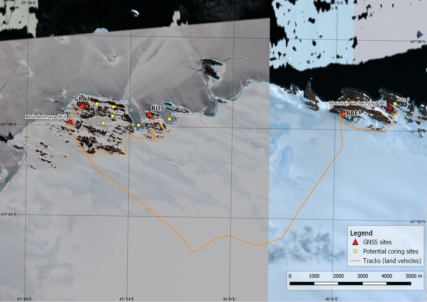
Abb. 1: Die Untersuchungsgebiete E-B der Polarstern-Expedition PS128:
Rote Kästchen kennzeichnen Zielgebiete auf dem Schelf. Gelbe Kreise markieren eine Auswahl
von ehemaligen Kernlokationen. Die weiße Linie zeigt die gemittelte Position der 15 % Sommer-
Meereisausdehnung. Die blauen Linien P1 bis P6 zeigen Beispiele für Parasound-Profile.
Lützow Holm Bay, Camp Glubokoje und Mawson markieren Ziele für Landexpeditionen.
Fig. 1: Study areas E–B of Polarstern expedition PS128:
Red boxes indicate target areas on the shelf. Yellow circles mark selection of
former sediment cores. The white line shows the averaged position of the 15 % summer sea ice
extent. The blue Lines P1 to P6 show examples of parasound profiles.
Lützow Holm Bay, Camp Glubokoje and Mawson mark terrestrial activities.
3Expedition Programme PS128
SUMMARY AND ITINERARY
Ralf Tiedemann1, Juliane Müller1 1
DE.AWI
Expedition EASI-1 (East Antarctic Ice Sheet Instability) represents the first of three proposed
expeditions that will examine the history of East Antarctic Ice Sheet Instability and its interaction
with changes in Southern Ocean (SO) circulation. The behavior of the East Antarctic Ice Sheet
(EAIS) under projected anthropogenic warming is a key uncertainty in predicting future sea
level rise due to the influence of strong ice-ocean feedbacks, which are poorly understood.
Reconstructing and disentangling these feedbacks during past warmer-than-present climate
states is considered to provide an enhanced basis for improved prediction of future changes in
the ice-ocean-climate system. Our goal is to acquire marine and terrestrial sediment records,
in combination with oceanographic, marine-geophysical, and continental-geodetic data. Our
work will focus on the Antarctic continental margin between the Weddell and Cooper Seas.
The main focus of EASI-1 is to enhance our knowledge about changes in: Antarctic bottom
water formation at Cape Darnley, ocean heat transport to the ice-shelf cavity below Neumayer
Station III, grounding-line behaviour, sea ice cover, meltwater supply, and oceanic stratification.
Recovery of long sediment records and surface sediments will be accompanied by bathymetric,
sediment echosounding, and hydrographic surveys (including water and plankton sampling).
In addition, we plan to conduct a seismic survey across the continental shelf to the sedimentary
structures below Ekström Ice Shelf (EIS), known from vibroseis surveys, to quantify the pre-
glacial and glacial sedimentation processes.
The expedition contributes to the goals of the Helmholtz Association's Programme-oriented
Funding (PoF), the research programme "Changing Earth – Sustaining our Future". The goals
of our expedition are closely related to this programme, in particular to the topic "Ocean and
Cryosphere in Climate". Within this topic, the causes, mechanisms and consequences of "sea
level rise", "climate warming" and "climate variability and extremes" will be investigated based
on a combined approach of observations, reconstructions (modern and palaeo) and Earth
system modelling.
Cruise leg PS128 will begin in Cape Town on 6 January 2022 and end in Cape Town on
28 February 2022. Already in transit to Antarctica the first study area (E) is to be found between
DelCano Ridge / Conrad Ridge and the Antarctic continental slope off Enderbyland. On
13/14 January our land group will be dropped off at the Belarusian station Gora Vechernyaya
(Camp Glubokoye) for their two-week field work in the Molodeshny Oasis region. Meanwhile, the
marine work on the continental slope off Cape Darnley is being carried out in close coordination
with our Australian cooperation partners (study area D), who are on site at the same time with
their research vessel Investigator. At the end of January, the land party will be picked up and the
marine work will be continued in study area C (Gunnerus Ridge, Riiser-Larsen Sea, Lasarev
Sea). Depending on weather and sea ice conditions, short land expeditions are also possible.
A final research focus of the expedition is geophysical and geological work on the shelf and
continental slope in the area of Neumayer Station III (working area B). After completion of the
work, Cape Town will be approached by the shortest route.
42. MARINE GEOLOGY AND PALEOCEANOGRAPH
Ralf Tiedemann1, Juliane Müller1, 1
DE.AWI,
Johann Klages1, Pascal Daub1, 2
DE.GEOMAR,
Wee Wei Khoo1, Norbert Lensch1, 3
UK.UNI-SOUTHAMPTON-SOES,
Dirk Nürnberg2, Lester Lembke-Jene1, 4
DE.CAU-GEOWISS,
Taina Pinho1, Vincent Rigalleau1, 5
JP.KOCHI-U.AC,
Lisa Schönborn1, Valea Schumacher1, 6
UK.BAS,
Thomas Arney3, Henning Bauch1, 7
AU.GA.GOV,
Bernhard Diekmann1, Gesine Mollenhauer1, 8
AU.UQ.EDU.SEES,
Thorsten Bauersachs4, Matthieu Civel-Mazens5, 9
AU.ANU.EDU,
Lea Fuchs11, Alina Ivanova11, Hinner Preckel11, 10
NZ.GNS.CRI,
Ebbe Nürnberg12, Patricia Sonnemann13 11
DE.UNI-Bremen,
12
DE.UNI-GREIFSWALD,
Not on board: Frank Lamy1, Oliver Esper1, 13
AT.UIBK.AC
Claus-Dieter Hillenbrand6, Alix Post7,
Helen Bostock8, Leanne Armand9,
Guiseppe Cortese10
Grant No. AWI_PS128_01
Objectives and scientific programme
The overall goal is to enhance our understanding on the late Paleogene to Quaternary processes
as well as the orbital to submillennial-scale evolution of ice-ocean-climate interactions during
deglacial warming and climate intervals that were warmer than today. Therefore, we plan
to probe marine sediment archives along the continental margin of Dronning Maud Land,
Enderby Land and Mac. Robertson Land. Particular attention will be paid to processes that
are related to basal ice shelf melting, including Warm Deep Water (WDW) intrusions into the
ice shelf cavities and feedback mechanisms (e.g. freshening, sea ice cover) that control the
formation and extent of Antarctic Bottom Water (AABW). Key hypotheses we will address in
this context are:
• Marine ice-based portions of the Antarctic ice sheet collapsed during warmer
than‑present times at a temperature anomaly threshold of 2 – 3° C.
• The marine-based East Antarctic ice portions are similarly unstable as the West Antarctic
Ice Sheet.
• The frequency, duration and extent of cross-continental shelf intrusions of warm
Deep Water control the instability of ice sheets during past interglacials.
• Antarctic sea ice varied asynchronously with Arctic sea ice extent over centennial to
millennial times scales and synchronously on orbital times scales.
5Expedition Programme PS128
• Sea ice retreat favours the destabilization of ice shelves, accelerating continental ice
mass loss.
• Changes in ice sheet melt and freshwater input affect Southern Ocean circulation
and ecosystem processes, e.g. through fundamental changes in formation rates and
physical and biogeochemical characteristics of abyssal AABW.
An important backbone to validate these hypotheses is the development of high resolution
age models. Precise timeframes are required to allow for comparisons with other existing
high-resolution climate proxy records derived from sediment and ice cores. We will apply a
variety of stratigraphic methods, including marine oxygen isotope stratigraphy, 14C-dating
techniques, 230Thex, 231Paex/230Thex methods, cross-correlation of proxy records with other
well-dated records, paleomagnetics and tephrachronology. Other options (yet to be tested)
include correlating proxy records from sediment and ice cores, that indicate changes in sea
ice variability (e.g. Abram et al. 2013) by assuming synchronous variability. This could anchor
the sediment stratigraphy to e.g. the ice core chronology of the EPICA DML ice core (EPICA
Community Members, 2006).
The sediment archive at the continental margin off Neumayer Station III provides large quantities
of well-preserved planktonic and benthic foraminifers (Grobe and Mackensen 1992) and
thus, the opportunity to reconstruct glacial/interglacial temperature variations on centennial/
millennial to orbital timescales from the surface into the deep water. Temperatures will be
reconstructed by means of Mg/Ca paleothermometry on planktic and benthic foraminifers
(Nürnberg et al. 2000), the organic biomarker-based indices TEXL86 and RI-OH’ (Ho et al. 2014;
Lamping et al., 2021; Park et al., 2019) and diatom/radiolarian transfer functions (Gersonde
et al. 2005; Civil-Mazens et al. in prep.). Sea ice reconstructions will be based on analyses
and intercomparisons of specific biomarker lipids (highly branched isoprenoids) and diatom
assemblages. These studies will allow to assess the role of “Warm Deep Water” in ice-shelf
melting and the response of the SO and sea ice to meltwater-induced freshening.
The sediment archives proximal and distal to the Cape Darnley Polynya offer an excellent
opportunity to assess past changes in Cape Darnley Bottom Water/AABW formation, which
is of global significance. A multi-proxy approach is required to reconstruct and understand
the system (Borchers et al. 2016; Vorrath et al. 2019; Rickli et al. 2014). We will reconstruct
changes in sea ice production, biogenic productivity, Nd isotopes and Rare Earth Elements
indicative of the provenance of current-derived and ice-transported material as well as past
regional changes in overturning circulation.
Our studies also aim to significantly improve our understanding of past EAIS extent, its flow
and retreat patterns, and the related bed processes that controlled ice flow primarily since the
last glacial to the Holocene (Klages et al. 2016; 2017). We will integrate and link bathymetric,
seismic, marine geological, and modelling competence to map and document temporal
changes in grounding line dynamics since the LGM.
Work at sea
Bathymetric and hydroacoustic surveys are used to identify (1.) core locations ideally containing
undisturbed sediment sequences, (2.) sites with high sediment accumulation, (3.) sites that
comprise the last 500 ka in the upper 20 m of the sediment archive and (4.) grounding lines,
moraines and scour marks.
The standard coring programme includes the operation of the multicorer (MUC) and the piston/
gravity/box corer (PC/GC/BC). In area E (Fig. 1), we plan to retrieve new records and revisit
former (key-) core locations to obtain fresh and additional material for measuring biomarkers
6Expedition Programme PS128
as well as established and new proxies. For example, at Conrad Rise we will re-visit coring
locations (Fig. 1), where our sample material is depleted or not suitable for biomarker studies.
Sediment records from the deep-sea basin (away from turbidites, area E) will be used to
reconstruct changes in AABW dynamics. In area D, the work program is almost identical to
that in area B, as we plan transects of sediment records from the Cape Darnley Polynya on the
shelf and across the continental margin into the deep sea basin. In close proximity to the EIS,
we will complement previous sub-ice shelf coring campaigns to define the extent and timing of
grounded ice beneath and offshore the EIS. This work to constrain the past extent and retreat
pattern of grounded ice and its timing since the LGM will continue in area C by combining
information from multibeam and sediment echosounders with appropriate coring locations (KC
and GC) on selected shelf sectors. In addition, we will collect sediment cores along a selected
transect from the shelf towards more distal sites to obtain fresh/undegraded material (e.g. for
biomarker studies) to reconstruct changes in ice cover and sea (sub)surface temperatures. In
area B, we will perform an extensive sediment coring programme, targeting on sites distributed
in water depth from 500 – 4,000 m to reconstruct the vertical water mass architecture and
the different physical and chemical signatures of water masses. At foraminifer-bearing key
stations, we will use the Kasten Corer (KC) and/or triple coring (PC/GC) to ensure that sufficient
foraminifers are available for the application of certain paleoceanographic proxies and 14C
datings.
Gravity cores will be cut into 1 m sections and stored at 4° C. Prior to storage, all core sections
will be analyzed for physical properties of the entire core using a Multi-Sensor-Core-Logger
(MSCL-S, Geotek Ltd.). The MSCL device provides data at 1 cm depth intervals of wet-bulk
density, porosity, p-wave velocity and magnetic susceptibility. Full processing of MSCL raw
data will be carried out at sea, so that high resolution records of physical properties are
available during the cruise. Selected sediment cores will be split onboard. Core images,
descriptions of sediment properties and smear slide investigations of these cores allow an
initial characterization of the sediments. However, some of the sediment cores remain unsplit
until arrival at the home laboratories because the expected number of sediment cores is
too high. Sampling of the Multi Corer sediment records (1 cm slices) into combusted glass
vials (biomarker) and Whirlpack sampling bags will take place onboard. Samples designated
for biomarker studies and ancient DNA analyses at home laboratories at AWI and Christian
Albrechts University in Kiel will to be stored frozen (–20° C). Water samples will be filtered on
board, acidified and subsequently co-precipitated.
Expected Results
In general, our expedition will provide new data and samples from key regions along the
East Antarctic continental margin that will enhance our understanding of processes related to
interactions in the ice-ocean-bedrock-climate system. This should improve our assessment
of future ice sheet instability and associated changes in Southern Ocean circulation and
ventilation.
On board, the combination of bathymetric and subsurface sediment features (parasound) in
combination with core descriptions will already provide information on sedimentary structures
and their morphological history in relation to former ice coverage, sub-ice hydrological conditions
(sub-glacial lakes, meltwater channels), ice-flow dynamics and possible past natural collapses
of ice shelves.
Sample and data management
The entire international community involved in the planned expedition will have immediate
and preferential access to the cruise report, to shipboard data and samples retrieved. The
7Expedition Programme PS128
availability of expedition data and samples may remain restricted to others not directly involved
in the project. After a moratorium period that protects the interests of the project partners, the
scientific community will have open access to data and samples.
In principle, AWI’s research data policy follows the principles for the responsible handling of
research data, which are based on the recommendations of the Helmholtz Association for
guidelines on the management of research data, on the Guidelines of the European Commission
on Data Management according to the FAIR principles and the guidelines of the Deutsche
Forschungsgemeinschaft on handling research data.
AWI aims to publish at least the primary scientific data as soon as possible. The open-access
cruise report will be published shortly after the cruise in the AWI series “Reports on Polar
and Marine Research”. It will contain detailed descriptions of the fieldwork conducted and
initial results obtained along with lists of samples and data collected during the cruise. All
data must be archived in a publicly accessible, citable long-term repository two years after
collection. The archived data may be under moratorium for a maximum of two additional
years. In addition, appropriate moratorium periods must be applied for and recorded in the
data management plan. After the embargo periods have expired, the data must be made public
immediately and actively using the FAIR principles. All data will be stored in international data
bases (e.g., PANGAEA, DOD, SCAR SDLS), preferably in the World Data Center PANGAEA
Data Publisher for Earth & Environmental Science (https://www.pangaea.de) operated as an
open-access library by the AWI and the Center for Marine Environmental Sciences, University
of Bremen (MARUM) within two years after the end of the cruise at the latest. By default, the
CC-BY license will be applied.
Sediment samples and cores collected during Polarstern expeditions are usually archived in
the AWI Core Repository, which is operated by the marine geology department since 1983.
Cores are stored in sealed D-tubes at 4° C and an air humidity limited at 35 %. The repository is
open to the scientific community for sampling subject to ongoing work at AWI including national
and international collaborations.
Any other data will be submitted to an appropriate long-term archive that provides unique
and stable identifiers for the datasets and allows open online access to the data .In all
publications, based on this cruise, the Grant No. AWI_PS128_01 will be quoted and the
following Polarstern article will be cited: Alfred-Wegener-Institut Helmholtz-Zentrum für Polar-
und Meeresforschung (2017) Polar Research and Supply Vessel POLARSTERN Operated by
the Alfred-Wegener-Institute. Journal of large-scale research facilities, 3, A119. http://dx.doi.
org/10.17815/jlsrf-3-163.
References
Abram NJ, et al. (2013) A review of sea ice proxy information from polarice cores. QSR, 79, 168–183.
Borchers A, et al. (2016) Holocene ice dynamics and bottom-water formation associated with Cape
Darnley polynya activity recorded in Burton Basin, East Antarctica. Marine Geophysical Research,
37(1), 49-70. https://doi.org/10.1007/s11001-015-9254-z.
EPICA Community Members (2006) One-to-one coupling of glacial climate variability in Greenland and
Antarctica. Nature 444, 195-198.
Gersonde R, et al. (2005) Sea-surface temperature and sea ice distribution of the Southern Ocean at
the EPILOG Last Glacial Maximum – A circum-Antarctic view based on siliceous microfossil records.
Quaternary Science Reviews 24 (7-9), 869-896.
8Expedition Programme PS128
Grobe H, & Mackensen A (1992) Late Quaternary climatic cycles as recorded in sediments from the
Antarctic continental margin. In J P Kennett, & D A Warkne (Eds.), The Antarctic Paleoenvironment:
A Perspective on Global Change, 349–376. Washington: AGU. https://doi.org/10.1029/AR056p0349.
Ho SL, et al. (2014) Appraisal of TEX86 and thermometries in subpolar and polar regions. Geochimica
et Cosmochimica Acta, 131, 213-226. https://doi.org/10.1016/j.gca.2014.01.001.
Klages J P, et al. (2016). A glacial landform assemblage from an inter-ice stream setting in the eastern
Amundsen Sea Embayment, West Antarctica. Geological Society London Memoirs 46, 349-352.
Klages JP, et al. (2017) Limited grounding-line advance onto the West Antarctic continental shelf in
the easternmost Amundsen Sea Embayment during the last glacial period. PLOS ONE 12(7),
(e0181593). https://doi.org/10.1371/journal.pone.0181593.
Lamping et al., (2021) Evaluation of lipid biomarkers as proxies for sea ice and ocean temperatures
along the Antarctic continental margin. Climate of the Past, https://doi.org/10.5194/cp-2021-19.
Nürnberg D et al. (2000) Paleo-sea surface temperature calculations in the equatorial east Atlantic
from Mg/Ca ratios in planktic foraminifera: A comparison to sea surface temperature estimates from
U37K‘, oxygen isotopes, and foraminiferal transfer function. Paleoceanography, 15(1), 124-134,
https://doi.org/10.1029/1999PA000370.
Park E, et al. (2019) Seasonality of archaeal lipid flux and GDGT-based thermometry in sinking particles
of high-latitude oceans: Fram Strait (79°N) and Antarctic Polar Front (50°S). Biogeosciences 16,
2247-2268.
Rickli J, Gutjahr M, Vance D, Fischer-Gödde M, Hillenbrand CD, Kuhn G (2014) Neodymium and
hafnium boundary contributions to seawater along the West Antarctic continental margin. Earth and
Planetary Science Letters 394, 99-110.
Vorrath ME, Müller J, Esper O, Mollenhauer G, Haas C, Schefuß E, Fahl K (2019) Highly branched
isoprenoids for Southern Ocean sea ice reconstructions: a pilot study from the Western Antarctic
Peninsula. Biogeosciences, 16, 2961-2981.
93. BATHYMETRY OF THE EAST ANTARCTIC SEA
Yvonne Schulze Tenberge1, Maybrit Gießler1, 1
DE.AWI
Ellen Unland1
not on board: Boris Dorschel1
Grant No. AWI_PS128_02
Objectives
Accurate knowledge of the seafloor topography, hence high-resolution bathymetry data, is a
basic key information and necessary to understand many marine processes. It is of particular
importance for the interpretation of scientific data in a spatial context. Bathymetry, hence
geomorphology, is furthermore a fundamental parameter for understanding the general
geological setting of an area and geological processes such as erosion, sediment transport
and deposition. Even information about tectonic processes can be inferred from bathymetry.
While world bathymetric maps give the impression of a detailed knowledge of worldwide
seafloor topography, most of the world’s ocean floor remains unmapped by hydroacoustic
systems. In these areas, bathymetry is modelled using satellite altimetry with a corresponding
low resolution. Satellite-altimetry derived bathymetry therefore lack the resolution necessary
to resolve small- to meso-scale geomorphological features (e.g. sediment waves, glaciogenic
features and small seamounts). Ship-borne multibeam data provide bathymetric information at
a resolution sufficient to resolve these features and enable site selection for the other scientific
working groups on board.
Glacigenic landforms preserved at the seafloor can form the basis for the reconstruction of
the dynamic history of the East Antarctic Ice Sheet. In particular, these landforms can shed
light on its retreat since its maximum extent during the Last Glacial Maximum. Understanding
the processes that led to this ice sheet retreat in the past can provide important information
for predicting future responses of the East Antarctic Ice Sheet to changing climate conditions
and oceanographic settings. Glacigenic landforms can only be determined in high-resolution
bathymetric data sets. However, for the study areas of the EASI1 expedition in the Indian
Ocean sector of the Southern Ocean, these data are sparse. It is therefore planned to acquire
detailed bathymetric data of these areas with the ship's hydroacoustic instruments.
Furthermore, the collection of underway data during PS128 will contribute to the bathymetry
data archive at the AWI and thus to bathymetric world datasets such as GEBCO (General
Bathymetric Chart of the Ocean).
Work at sea
The bathymetric data will be recorded with the Atlas Hydrosweep DS3 hull-mounted multibeam
echosounder. The main task of the bathymetry group is to plan and run bathymetric surveys
in the study areas and during the transit. The raw bathymetric data will be corrected for sound
velocity changes in the water column, further processed and cleaned for erroneous soundings
10Expedition Programme PS128
and artefacts. Detailed seabed maps derived from the data will provide information on the
general and local topographic setting in the study areas. The high-resolution seabed data
recorded during the survey will be made available for site selection and cruise planning. During
the survey, the acoustic measurements will be carried out by three operators working 24/7 hour
shifts (except for periods of stationary work).
Preliminary (expected) results
Expected results will consist of high-resolution seabed maps along the cruise track and from
the target research sites. The bathymetric data will be analysed to obtain geomorphological
information of the research area. The expected results aim towards a better understanding of
the geological processes in the research area.
Data management
Geophysical and oceanographic data collected during the expedition will be archived, published
and disseminated according to international standards by the World Data Center PANGAEA
Data Publisher for Earth & Environmental Science (https://www.pangaea.de) within two years
after the end of the cruise at the latest. By default, the CC-BY license will be applied.
Furthermore, the data will be included in regional data compilations such as IBCSO (International
Bathymetric Chart of the Southern Ocean) and provided to the Nippon Foundation – GEBCO
Seabed 2030 Project.
In all publications, based on this cruise, the Grant No. AWI_PS128_02 will be quoted and the
following Polarstern article will be cited:
Alfred-Wegener-Institut Helmholtz-Zentrum für Polar- und Meeresforschung (2017) Polar
Research and Supply Vessel POLARSTERN Operated by the Alfred-Wegener-Institute.
Journal of large-scale research facilities, 3, A119. http://dx.doi.org/10.17815/jlsrf-3-163.
114. MARINE GEOPHYSICS/PARASOUND
Karsten Gohl1, Estella Weigelt1, 1
DE.AWI,
Christoph Gaedicke , Thorsten Eggers ,
2 1 2
DE.BGR,
Adalbert Pfeiffer1, Jakob Hamann1, 3
AR.MARYBIO
Alejandro Cammareri3, Juan Manuel Salazar1
Grant No. AWI_PS128_04
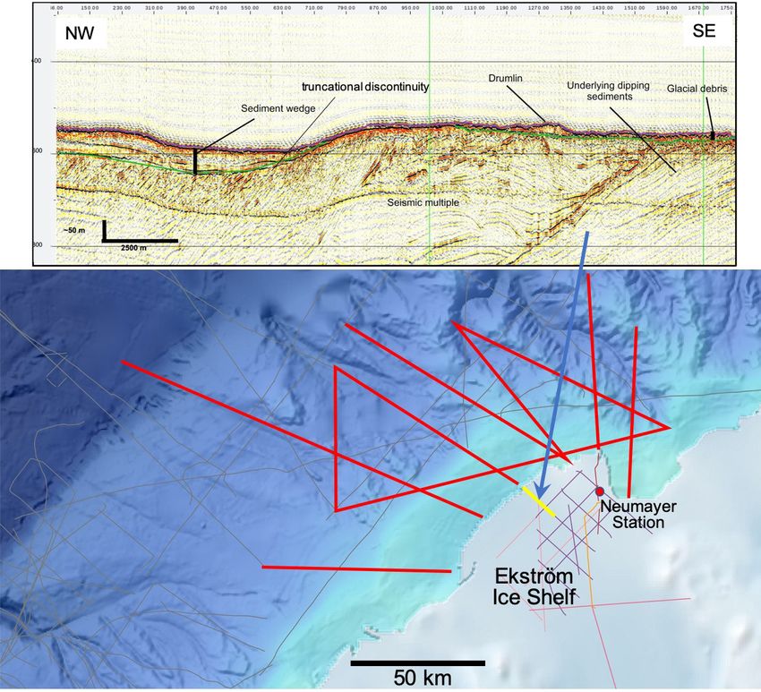
4.1 The continental-marine seismic link of Dronning Maud Land:
Reconstructing the long-term evolution of the Ekström ice streams
Objectives
The ice stream system feeding into the Ekström Ice Shelf represents one of the numerous
small outlet glacier systems of East Antarctica. Considering that the behaviour of the EAIS
with increasing global temperature is hardly known, a thorough assessment of the glacial
dynamics of such a small outlet glacier system can provide important constraints on large
proportions of the EAIS. A joint project between the Bundesanstalt für Geowissenschaften und
Rohstoffe (BGR) and the AWI studies the potential of the sedimentary archive below the EIS
for reconstructing Antarctic ice history and paleoclimate from warm Greenhouse climates to
the latest Ice House era. A network of seismic profiles, including vibroseis lines (Fig. 2), has
been acquired in the last 5 years and reveals a sequence of northward dipping, pre-glacial
sediments overlain by glacial deposits showing near-seafloor and deeper buried features
of glacial transport processes such as truncational discontinuities, grounding zone wedges
and overdeepened sub-basins (Kristoffersen et al. 2014; Smith et al., 2019). As these glacial
deposits are likely to continue offshore across the entire continental shelf, we aim to connect
the seismic ice shelf network to the inner and outer continental shelf with additional seismic
profiles in order to map the entire shelf sequences. Some seismic units and horizons can be
dated via seismic correlation to the distal ODP Leg 113 drill sites near the Explora Escarpment
of the eastern Weddell Sea and on Maud Rise. This will allow a complete seismo-stratigraphic
analysis from early glacial periods to Quaternary glacial/deglacial cycles and a quantification
of glacially induced variations in sediment transport during relevant warm times and colder
periods within this Dronning Maud Land sector, which may be representative of many small
glacier outlet regions of East Antarctica. Accordingly, the main goal is to decipher the sediment
transport processes for deriving ice-sheet dynamics during major past warm periods from the
Ekström Ice Shelf region.
12Expedition Programme PS128
Fig. 4.1 Map showing existing (thin lines) as well as planned seismic profiles (thick red lines) on the
continental shelf off the Ekström Ice Shelf (EIS) of Dronning Maud Land. The EIS was surveyed with
vibroseis profiles (thin coloured lines) of which one example is shown above (marked as yellow line).
Work at sea
For the extension and connection of the seismic networks in area B, about 800 km (432 nm)
of seismic profiling will be acquired on the continental shelf off the EIS (5 days including
deployment / retrieval of seismic equipment and circumventing massive sea ice) by using a
600 m digital seismic streamer and seismic airgun sources. The exact profile locations will
depend on sea ice conditions at the time of the expedition. If we identify a potential IODP
drilling location, we will be prepared to perform the required seismic and bathymetric surveys.
Preliminary (expected) results
It can be expected that the offshore seismic profiles will provide images of glacially transported
and deposited sediment sequences on the continental shelf off the EIS region. In connection
to pre-existing seismic profiles on the continental rise and deep sea with links to ODP Leg
113 drill sites as well as to the pre-existing vibroseis lines on the EIS, we expect to decipher
dominant phases of past EAIS advances and retreats in this DML sector.
13Expedition Programme PS128
Data management
Meta data and a short report will be submitted to DOD and PANGAEA. A full cruise report
will be made available from PANGAEA within 6 months after the cruise. Seismic data will
be submitted to the SCAR Antarctic Seismic Data Library System (SDLS) from which they
will be made available to other users 4 years after data acquisition. Access for the science
community will also be provided according to international standards by the World Data Center
PANGAEA Data Publisher for Earth & Environmental Science (https://www.pangaea.de) within
three years after the end of the cruise (moratorium period) at the latest. By default, the CC-BY
license will be applied.
In all publications, based on this cruise, the Grant No. AWI_PS128_04 will be quoted and the
following Polarstern article will be cited:
Alfred-Wegener-Institut Helmholtz-Zentrum für Polar- und Meeresforschung (2017) Polar
Research and Supply Vessel POLARSTERN Operated by the Alfred-Wegener-Institute.
Journal of large-scale research facilities, 3, A119. http://dx.doi.org/10.17815/jlsrf-3-163.
References
Kristoffersen Y, et al. (2014) Reassembling Gondwana: A new high-quality constraint from vibroseis
exploration of the sub-ice shelf geology of the East Antarctic continental margin. J. Geophys. Res.
Solid Earth, 119, 9171-9182, https://doi.org/10.1002/2014JB011479.
Smith EC, Hattermann T, Kuhn G, Gaedicke C, Berger S, Drews R, et al. (2020) Detailed seismic
bathymetry beneath Ekström Ice Shelf, Antarctica: Implications for glacial history and ice-ocean
interaction. Geophysical Research Letters, 47, https://doi.org/10.1029/2019GL086187
4.2 Parasound: Sub-bottom profiling in the Indian Ocean sector of the
Southern Ocean and along the Antarctic continental margin
Objectives
Accurate knowledge of the upper sedimentary strata via sub-bottom profiling data is necessary
to study glacial-marine sedimentation processes of the younger past. The data provide basic
information about the upper meters of subsoil for understanding geological processes such
as erosion, sediment transport and deposition, or even tectonic processes. Glacially formed
structures (e.g. moraines) preserved in the sub-bottom can help reconstruct the dynamic
history of East Antarctic Ice Sheet, and can shed light on its retreat since its maximum extent
during the Last Glacial Maximum. Understanding the processes that led to ice sheet retreat in
the past can, in turn, provide important information for predicting future responses of the East
Antarctic Ice Sheet to changing climate and oceanographic settings.
Imaging the upper few tens of meters, the sediment echography presents an important link
between bathymetry (mapping the surface morphology) and reflection seismics (imaging the
deep structures down to several km depth). Further, the integration of these three data sets is
of particular importance for the interpretation of geological data in a spatial context.
The survey by sediment echography “Parasound” is essential to identify (1) core locations
ideally containing undisturbed sediment sequences, (2) sites with high sediment supply.
14Expedition Programme PS128
Work at sea
Sediment echograph data will be recorded using the Atlas Teledyne Parasound P70 hull-
mounted sub-bottom profiling system. The main task of the sediment echography group is to
run surveys in the study areas and during transit, to provide information for station planning
and sediment sampling sites. Profiling will be carried out in a 24-hour/7-day shift mode, and the
data recorded will be promptly made available for site selection and cruise planning.
The detailed sub-bottom maps derived from the sediment-echography data will provide
information on glacial-geomorphological features (e.g. grounding zone wedges), erosional
structures, and depositional features (e.g. slumps, slides, fans). For the selection of coring
locations, the data enable to identify areas of high and low sedimentation rates, outcrops, and
to avoid areas of sediment redeposition and erosion.
Preliminary (expected) results
Expected results will consist of high-resolution seabed maps along the cruise track and from
the target research sites. The sub-bottom data will be analyzed to provide geomorphological
information about the uppermost sedimentary sequences of the research area. Expected
results aim towards a better understanding of the geological processes in the research area.
Data management
Sub-bottom profiling data collected during the expedition will be archived published and
disseminated according to international standards by the World Data Center PANGAEA Data
Publisher for Earth & Environmental Science (https://www.pangaea.de) in accordance to the
AWI research data guideline and directive (https://hdl.handle.net/10013/epic.be2ebee5-fb98-
4144-9e74-aa1d38378c5e). The data will be made available upon request after a phase of
restricted access of 4 years after data acquisition at the latest. By default, the CC-BY license
will be applied.
In all publications, based on this cruise, the Grant No. AWI_PS128_04 will be quoted and the
following Polarstern article will be cited:
Alfred-Wegener-Institut Helmholtz-Zentrum für Polar- und Meeresforschung (2017) Polar
Research and Supply Vessel POLARSTERN Operated by the Alfred-Wegener-Institute.
Journal of large-scale research facilities, 3, A119. http://dx.doi.org/10.17815/jlsrf-3-163.
155. MARINE GEOCHEMISTRY: WATER COLUMN, BOTTOM
WATER AND SEDIMENTARY POREWATER ANALYSES
Marcus Gutjahr1, Huang Huang2, 1
DE.GEOMAR,
Frerk Pöppelmeier3, Xia Jinqi2, 2
CN.SYSU,
Gastón Kreps4,5, Gesine Mollenhauer5 3
CH.UNIBE,
4
AR.UBA
5
DE.AWI
Grant No. AWI_PS128_05
Objectives
The Atlantic and Indian Ocean sector of the Southern Ocean (SO) is a hydrologically highly
dynamic basin. It is dominated by the eastward flowing and vertically well mixed Antarctic
Circumpolar Current (ACC). Its deeper portions are occupied by Antarctic Bottom Water,
dominantly but likely not exclusively sourced from the Weddell Sea. South of the ACC, the
presence of the westward flowing Antarctic Slope Current (Williams et al. 2010) forms a thermal
buffer zone around the East Antarctic Ice Sheet (EAIS) with near-freezing temperatures,
preventing substantial submarine basal melting at present. The formation of new Antarctic
Bottom Water (AABW) in front of the marine-based EAIS is a further important process in
Antarctic waters. While the most important Antarctic Deep Water formation areas have long
been known to lie in the southern Weddell and Ross Sea (e.g. Orsi et al. 1999; Purkey et al.
2018), other locations of AABW formations have been identified more recently such as the
Cape Darnley region (Meijers et al. 2010; Williams et al. 2016; Williams et al. 2010). Generally
speaking, AABW has warmed, declined in volume and freshened in recent decades, which
likely will have consequences for the global sea level rise and heat budgets (Purkey et al.
2018). In this context, the water column work to be realized here will serve as an important
assessment of the current state of regional AABW formation along the EAIS.
A major target for PS128 is the study of neodymium (Nd) isotope systematics within the water
column. Neodymium belongs to the group of Rare Earth Elements (REE) and is systematically
incorporated into continental and oceanic crust with unique isotopic signatures. Neodymium
isotopes are also an increasingly employed tool to investigate the origin and flow path of water
masses in the oceans today and in the past. This trace metal is supplied to the oceans through
physico-chemical weathering on land and on the seafloor in shallow marine and continental
rise settings. A recent modelling study reports that the relative contributions of Nd to seawater
are ~60 % via boundary/benthic additions (i.e., from sediments to bottom water), ~32 % from
riverine inputs, and ~9 % from partial dissolution of dust in the water column (Pöppelmeier
et al., 2020). The Nd isotope signature thus reflects the isotopic signal of the material dissolving
on land, in the water column (dust), or on the seafloor. As a consequence, water masses in
contact with the ocean margin often change their isotopic composition successively along
their flow path, whereas in the open ocean Nd isotopic compositions remains constant unless
a parcel of water is mixed with another parcel of water with a different isotopic composition.
Neodymium can therefore be categorized as behaving semi-conservative in seawater with a
mean global residence time of about 690 years (Pöppelmeier et al. 2020). Earlier work by the
PIs in the southern and northwestern Weddell Sea during PS111 (2018) and PS118 (2019)
16Expedition Programme PS128
has already provided insights into the Nd isotopic and concentration behaviour in these areas,
also highlighting localised hotspots of Nd addition to bottom waters on the shelf and Antarctic
continental rise, most clearly resolvable along the northern Antarctic Peninsula. The Work
to be realised during PS128 will extend this new database to East Antarctic areas that are
hitherto largely unsampled for this emerging geochemical isotope water mass tracer.
Global climate is critically sensitive to physical and biogeochemical dynamics in the subpolar
Southern Ocean, since it is here that deep, carbon-rich layers of the world ocean outcrop
and exchange carbon with the atmosphere (e.g., MacGilchrist et al. 2019). It is also here that
much of anthropogenic carbon is taken up by the ocean (and enhanced glacial ocean carbon
storage in the deep Southern Ocean is well established (e.g., Brovkin et al. 2012)). Changes in
Southern Ocean carbon uptake and its export to depth are thus strongly impacting the global
carbon cycle. The role of the Southern Ocean in anthropogenic carbon uptake has long been
identified (Caldeira and Duffy, 2000), and it has been suspected that climate warming reduces
the efficiency of this anthrogenic carbon uptake. More recently, the strength of this carbon sink
has been described to have re-invigorated (Landschützer et al. 2015).
The distribution of deep ocean Δ14C data of dissolved inorganic carbon (DIC) are often used
to illustrate the rate of deep ocean circulation, as radiocarbon is an invaluable tool to trace
exchange processes in the carbon cycle and to estimate time in closed reservoirs. For instance,
Δ14C of DIC can be used to map the uptake of atmospheric CO2 into the ocean, or reflect
input of aged carbon from the sea floor originating, e.g., from geologic sources. Despite their
usefulness, high-resolution profiles of Δ14C of DIC in the water column are scarce, in particular
for the Southern Ocean. The current state of knowledge is based on a large international effort,
the World Ocean Circulation Experiment conducted in the early 2000s.
The second largest carbon pool in the ocean consists of dissolved organic carbon (DOC),
whose cycling is linked to the cycles of DIC and its particulate organic matter. DOC has been
reported to be up to several thousand years old in deep waters, and the mechanisms of aging
remain unresolved yet. It has been reported that DOC radiocarbon content decreases along
with that of DIC, suggesting that transport of deep waters is the primary control of 14C in DIC
and DOC in the Southern Ocean (Druffel et al. 2021). As with DIC, high-resolution profiles of
DO14C in the water column remain scarce.
As a first objective, the marine geochemistry team onboard PS128 will monitor the modern
hydrological configuration, also including standard physical oceanographic parameters
and oxygen concentrations. This is not only important for understanding the current state
of SO's overturning dynamics, but will also serve as reference for any paleoceanographic
reconstructions that will be realized using PS128 sediments (Chapter 2). Given the geochemical
behaviour of Nd and DIC will be as outlined above, we will also specifically target the ocean
floor by collecting multi core water (MUC water) that contains information about the Nd isotopic
composition and DI14C at the ocean floor. In contrast to the standard CTD rosette seawater
sampling that is usually targeting maximum depths at least five metres above the seafloor, we
can hence directly target ocean water at the sediment – bottom water interface, a key locality
for a variety of essential trace metals and micronutrients, including Nd.
The CTD and MUC water sampling work will further be complemented by the extraction of local
marine porewaters that we will separate from multi cores at selected sites that will be obtained
in close cooperation with the Marine Geology group (Chapter 2). Last but not least, the water
column and benthic porewater work will be further extended by the sampling of continental ice
containing Antarctic rock debris that PI M. Gutjahr is carrying out in cooperation with the land
geology group onboard PS128 (Chapter 6).
17Expedition Programme PS128
Work at Sea
Water column samples for Nd isotopic and REE analyses will be collected by means of a
CTD rosette. For selected water depths seawater oxygen concentrations obtained using the
oxygen sensor attached to the CTD rosette will be calibrated against discrete water samples
onboard using standard procedures (Winkler titration). The locations of the water sampling
stations will be coordinated with Marine Geology stations to obtain a comprehensive picture
from the sediments, across the sediment-bottom water interface into the open water column.
Station time permitting, we will sample the open SO water column towards our transect to
Antarctic coastal waters, carry out spatially finer resolved water sampling in the Cape Darnley
area, but also target near-Antarctic waters in regular intervals on our transect west along the
East Antarctic continental margin. We will pay particular attention to potential regional hotspots
of AABW formation. Seawater samples will also be aliquoted for carbonate chemistry and
radiocarbon (D14C; to be realised by Gesine Mollenhauer). Additional samples will be taken for
measurements of DO14C.
We will further separate sedimentary porewaters obtained from MUC sampling via centrifugation
processed following trace metal clean sampling protocols in an oxygen-free atmosphere (using
argon in glove bags) allowing reliable determination of contamination-prone trace metals and
their isotopic compositions as well as DI14C. Sampling of the MUCs (2 cm slices) will also be
realised to analyse key geochemical porewater properties (alkalinity, sulphate, nitrate, various
trace metal concentrations).
The water samples will be filtered on board, acidified and, in the case of samples for trace metal
analyses, subsequently co-precipitated using Fe chloride. The samples then will be transferred
into appropriate storage vials (1L HDPE flasks, head-space vials, or 50 mL centrifuge vials
during the cruise). All sedimentary porewater samples will also be sampled, centrifuged and
filtered already onboard. Samples designated for nutrient and IC analyses at home laboratories
at GEOMAR Kiel need to be stored frozen (–20° C), while porewater samples used for trace
metal analyses will be further acidified to pH ~2 and taken home at ~4° C. Samples for DIC
analyses will be poisoned with Hg2Cl2 and stored at 4° C. After collection, the basal ice samples
will be stored in dedicated trace metal clean containers at –20° C and transported to GEOMAR
Kiel for further processing in the clean lab facilities.
Expected results
Neodymium in seawater behaves semi-conservatively, hence as long as water masses are
not in contact with the ocean margin they only change their Nd isotopic composition (eNd) as
a function of water mass mixing. For sites within the northern open water stations of PS128
we will therefore trace ƐNd of ACC water masses and Weddell Sea Deep Water (e.g. Stichel
et al. 2012). Given the expected continuous addition of Nd on the East Antarctic continental
shelf and along its continental rise via the sediment-bottom water interface at the seafloor,
these regional additions will be isotopically close to regional continental crust compositions.
In the study area regional continental crust is largely of Precambrian age with African and
Indian crustal affinities (Boger 2011). Roy et al. (2007) reported the presence of a crustal
Nd isotopic gradient along the East Antarctic margin. Overall, we expect to observe isotopic
gradients both along a latitudinal and longitudinal transects, with least radiogenic (lowest) ƐNd
being observed in Archean sections alongshore Dronning Maud Land. Whether the transfer
of sediment-derived trace metals to bottom water in the study will also lead to substantially
elevated bottom water Nd concentrations such as seen earlier along the West Antarctic shelf
(Rickli et al., 2014) will depend on the intensity of local bottom water currents, which we will
measure via ADCP. Physical oceanographic parameters (temperature, salinity, density) and
18Expedition Programme PS128
oxygen concentrations will help quantifying the current ventilation state of this part of the East
Antarctic continental margin. These parameters will also be invaluable for the interpretation of
the radiocarbon data.
In contrast to Nd, radiocarbon decays with a half-life of 5,730 years, making 14C of dissolved
inorganic carbon (DIC) a suitable tracer for water mass overturning. However, exchange
occurs between water and underlying sediments as well, potentially adding pre-aged carbon
to the pool of DIC in bottom waters, while recently ventilated waters will carry a radiocarbon
signature impacted by exchange with the atmosphere. We expect to quantify the impact of
both processes as well as water mass mixing on the DIC 14C signature and trace how they
impact this parameter along water mass trajectories.
Dissolved organic carbon (DOC) in deep-sea waters, in contrast, is known to exhibit substantially
lower 14C values, but the processes responsible for the accumulation of this “old” carbon pool
are poorly understood. With our sampling campaign, we plan to contribute novel data on
DOC 14C in a poorly sampled area and put them in context with the processes impacting
DIC 14C.
Data management
Environmental data will be archived, published and disseminated according to international
standards by the World Data Center PANGAEA Data Publisher for Earth & Environmental
Science (https://www.pangaea.de) within two years after the end of the cruise at the latest. By
default, the CC-BY license will be applied.
Any other data will be submitted to an appropriate long-term archive that provides unique and
stable identifiers for the datasets and allows open online access to the data.
In all publications, based on this cruise, the Grant No. AWI_PS128_05 will be quoted and the
following Polarstern article will be cited:
Alfred-Wegener-Institut Helmholtz-Zentrum für Polar- und Meeresforschung (2017) Polar
Research and Supply Vessel POLARSTERN Operated by the Alfred-Wegener-Institute.
Journal of large-scale research facilities, 3, A119. http://dx.doi.org/10.17815/jlsrf-3-163.
References
Boger SD (2011) Antarctica – Before and after Gondwana. Gondwana Research, 19, 335-371.
Meijers AJS, Klocker A, Bindoff NL, Williams GD, Marsland SJ (2010) The circulation and water masses
of the Antarctic shelf and continental slope between 30 and 80° E. Deep Sea Research Part II: Topical
Studies in Oceanography, 57, 723-737.
Orsi AH, Johnson GC, Bullister JL (1999) Circulation, mixing, and production of Antarctic Bottom Water.
Progress in Oceanography, 43, 55-109.
Pöppelmeier F, Gutjahr M, Blaser P, Oppo DW, Jaccard SL, Regelous M, Huang KF, Süfke F, Lippold
J (2020) Water mass gradients of the mid-depth Southwest Atlantic during the past 25,000 years.
Earth and Planetary Science Letters, 531, 115963.
Purkey SG, Smethie WM, Gebbie G, Gordon AL, Sonnerup RE, Warner MJ, Bullister JL (2018) A synoptic
view of the ventilation and circulation of Antarctic Bottom Water from chlorofluorocarbons and natural
tracers. Annu Rev Mar Sci, 10, 503-527.
19Expedition Programme PS128
Rickli J, Gutjahr M, Vance D, Fischer-Gödde M, Hillenbrand CD, Kuhn G (2014) Neodymium and
hafnium boundary contributions to seawater along the West Antarctic continental margin. Earth and
Planetary Science Letters 394, 99-110. Williams GD, Herraiz-Borreguero L, Roquet F, Tamura T,
Ohshima KI, Fukamachi Y, Fraser AD, Gao L, Chen H, McMahon CR, Harcourt R, Hindell M (2016)
The suppression of Antarctic bottom water formation by melting ice shelves in Prydz Bay. Nature
Communications, 7, 12577.
Roy M, van de Flierdt T, Hemming SR, Goldstein SL (2007) 40Ar/39Ar ages of hornblende grains
and bulk Sm/Nd isotopes of circum-Antarctic glacio-marine sediments: Implications for sediment
provenance in the southern ocean. Chemical Geology, 244, 507-519.
Stichel T, Frank M, Rickli J, Haley BA (2012) The hafnium and neodymium isotope composition of
seawater in the Atlantic sector of the Southern Ocean. Earth and Planetary Science Letters, 317-318,
282-294.
Williams GD, Nicol S, Aoki S, Meijers AJS, Bindoff NL, Iijima Y, Marsland SJ, Klocker A (2010)
Surface oceanography of BROKE-West, along the Antarctic margin of the south-west Indian Ocean
(30–80°E). Deep Sea Research Part II: Topical Studies in Oceanography, 57, 738-757.
206. CONTINENTAL GEOLOGY AND GEODESY
Sonja Berg1, Bernd Wagner1, Ole 1
DE.UNI-Köln,
Bennike2, Niklas Leicher1, Maria 2
DK.GEUS,
Kappelsberger4, Karl Heidrich-Meisner4 3
AU.GEOSCIENCE,
Not on board: M. Melles1, D. White3, 4
DE.TU-Dresden
M. Scheinert4
Grant No. AWI_PS128_06
6.1. Late Quaternary deglaciation and climate history of Thala Hills,
Enderby Land
Objectives
The East Antarctic Ice Sheet (EAIS) has long been recognized as stable, due to its characteristic
of being mostly grounded on bedrock lying above sea level (as opposed to the mostly marine-
based West Antarctic Ice Sheet). However, in the past decade modelling approaches and
field evidence have revealed that processes related to basal ice shelf melting, including
intrusions of relatively warm Circumpolar Deep Water (CDW) into the ice shelf cavities, may
also have a destabilizing effect on some portions of the EAIS (e.g., Deconto & Pollard 2016;
Rintoul 2018). As opposed to afflicted regions such as Wilkes Land, minimal changes or
even mass-gain have been observed in Enderby Land (Rignot et al. 2019). In this respect,
paleoglaciological reconstructions from this part of the EAIS may provide information on ice
and bed characteristics that foster ice sheet stability. The maximum ice sheet extent during the
Last Glacial Maximum (LGM, 19 to 23 ka) as well as the subsequent retreat history are still
largely unconstrained for Enderby Land (Bentley et al. 2014). Exposure ages of glacial erratics
indicate ice sheet retreat starting in the early to mid-Holocene (ca. 9 to 5 ka) at the flanks of
two outlet glaciers in Enderby Land and eastern Dronning Maud Land (White & Fink 2014;
Kawamata et al. 2020), see eastern part of area C in Figure 6.1. This timing of postglacial ice
retreat differs from coastal areas in Mac.Robertson Land, see eastern part of area D in Figure
6.1, where post-LGM ice-sheet thinning occurred significantly earlier and was likely initiated
by rising eustatic sea level around 14 ka (Mackintosh et al. 2011). The different timing of ice
retreat points to different regional drivers of deglaciation, which may be coupled with regionally
specific oceanographic and topographic properties.
In order to better understand the drivers of ice sheet stability/instability in relation to region-
specific characteristics, such as bed topography, shelf geometry and oceanographic parameters,
detailed studies are needed on understudied regions like Enderby Land. Within the scope
of expedition PS128 (EASI-1) we want to obtain new field data and sediment samples from
unglaciated coastal areas in the study region to
1. constrain the timing of ice sheet retreat and subsequent fluctuations in presently un-
glaciated areas
2. reconstruct climatic conditions following local deglaciation
21Sie können auch lesen