RAD & BIKE GUIDE BIKE GUIDE - Tourismusverband Piesendorf ...
←
→
Transkription von Seiteninhalten
Wenn Ihr Browser die Seite nicht korrekt rendert, bitte, lesen Sie den Inhalt der Seite unten
RAD & BIKE GUIDE
BIKE GUIDE
FÜR BIKE ENTHUSIASTEN                      FOR BIKE ENTHUSIASTS

Dieser Bike Guide mit eingeklebter         This Bike Guide with a glued in Bike
Bike Karte wird dich erfreuen.             Map will delight you.
Jedes einzelne Tourblatt ist perforiert,   Each individual tour sheet is perforated,
trenne deine ausgewählte Tour einfach      simply separate your selected tour.
heraus. Mit einem Gewicht von weniger      With a weight of less than 5 grams, it
als 5 Gramm wird es deine Performance      will not affect your performance.
nicht belasten.

INHALTSVERZEICHNIS                         I TABLE OF CONTENS

Allgemeine Information                     I   General Information          I   04-07

Mountainbike Touren                        I   Mountain Bike Tours          I   09-40

Trekking & E-Bike Touren                   I   Trekking & E-Bike Tours      I   41-52

Freeride Trails                            I   Freeride Trails              I   53-60

Rennrad Touren                             I   Road Bike Tours              I   61-70

Weitere Touren                             I   Further Tours                I   71-77

Radverleih                                 I   Bike Rental                  I   78

E-Bike Ladestationen                       I   E-Bike Charging Stations     I   79

E-Bike Servicestationen                    I   E-Bike Service Stations      I   79

Hütten & Jausenstationen                   I   Mountain Huts                I   80-81

Bike Karte                                 I   Bike Map                     I   83
MTB-LEITSYSTEM I                        MTB-SIGNAGE SYSTEM

                          In Österreich ist das Befahren des Waldes (z.B. auf Forstwegen,
                          aber auch auf Almwegen) nach dem Forstgesetz verboten.
                          Nur auf besonders ausgewiesenen Wegen, auf welchen die
                          Wegerhalter das Radfahren freigegeben haben, ist dies
                          möglich.
                          In Piesendorf Niedernsill sind die MTB-Routen mit dem
                          „Salzburger MTB-Leitsystem“ gekennzeichnet.

                          In Austria, driving in the forest (e.g. on forest roads, but also on
                          alpine pastures) is prohibited under the forest act. This is only
                          possible on specially marked paths on which the trail owners
                          have given permission for cycling.
                          In Piesendorf Niedernsill the MTB routes are marked with the
                          „Salzburg MTB Guidance System“.

TOUREN APP Piesendorf Niedernsill erleben

                Dein TOP-Begleiter in Piesendorf Niedernsill.
                  In Sekundenschnelle kannst du Touren
                  und Informationen abrufen!
                Your TOP companion in Piesendorf Niedernsill.
                  In seconds you can get tours and information!

Jetzt kostenlos erhältlich im Apple & Google Play Store!                  Mehr als 100 Touren
Download now for free on the Apple & Google Play Store.                   More than 100 tours
                                                                          Bike Karte
                                                                          Bike map
                                                                          Offline Speicherung
                                                                          Offline storaging
                                                                          Hüttenführer
                                                                          Huts guide
                                                                          GPS-Ortung
                                                                          GPS tracking
SCHWIERIGKEITSGRADE I                     LEVELS OF DIFFICULTY

      Leicht                            Easy
        Familienfreundlich                family friendly
        Gute Fahrbahndecke                good road surface
        Eher kurz                         relatively short
        Nicht steil (0 - 5 % Gefälle)     not steep (0 - 5 % gradient)
        Keine besonderen Gefah-           no praticular dangers
        renbereiche

      Mittel                            Medium
        Erfordert sportliches             demand sporty biking skills

                                                                             5
        Radfahrkönnen                     road surface demands moun-
        Fahrbahnbeschaffenheit            tain bike equipment
        erfordert Mountainbike            medium distance
        Ausrüstung                        steeper in some places (5 - 12 %
        Mittellange Strecken              gradient)
        Teilweise steiler (5 - 12 %       blind corners, winding passages
        Gefälle)                          possible
        Unübersichtliche, kurven-
        reiche Streckenabschnitte
        möglich

      Schwer                            Difficult
        Schwierige und an-                difficult and demanding
        spruchsvolle Strecken             mountain bike routes
        Steil bzw. mit steilen            steep or steeper passages
        Abschnitten                       mountain bike equipment
        Mountainbike Ausrüs-              is obligatory
        tung ist obligatorisch            adapt speed etc. to situation
        Situationsangepasstes             and anticipate dangerous
        und vorausschauendes              situations
        Fahren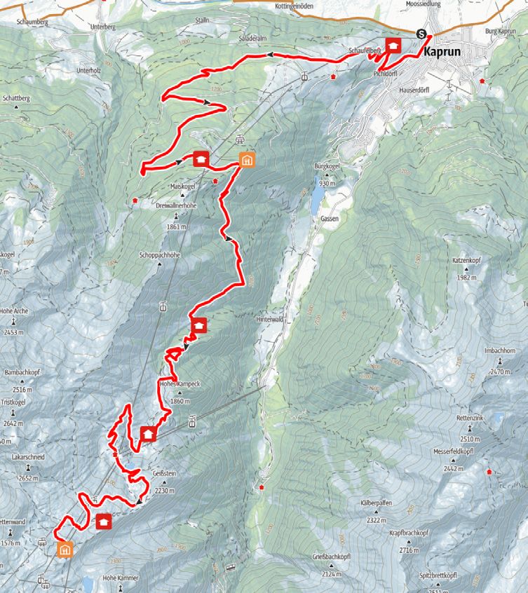
VERHALTENSREGELN

Verhaltensregeln für ein problemloses Miteinander
Das Biken ist nur auf markierten und freigegebenen Routen vom 1. Mai bis 15. No-
vember in der Zeit von 2 Std. nach Sonnenaufgang und 1 Std. vor Sonnenuntergang auf
eigene Gefahr gestattet.

   Fahre stets mit kontrollierter Geschwindigkeit und auf halbe Sicht, besonders bei
   Kurven, da jederzeit mit Hindernissen zu rechnen ist.
   Vermeide Lärm und unnötige Bremsspuren.
   Nimm Rücksicht auf Wanderer und Fußgänger und überhole nur im Schritttempo!
   Nimm Rücksicht auf den Schwierigkeitsgrad der Strecke und schätze deine Erfah-
   rungen und dein Können als Biker genau ein!
   Schütze deinen Kopf mit einem Helm und kontrolliere die Ausrüstung vor Antritt
   der Biketour (Bremsen, Licht, …)!
   Halte dich an Absperrungen und akzeptiere, dass dieser Weg primär der land- und
   forstwirtschaftlichen Nutzung dient!
   Schließe Weidegatter und Schranken!
   Hinterlasse keine Abfälle!

Respektiere deine Grenzen!
Die Naturlandschaft Salzburgs bietet Platz für Wildtiere, Pflanzen und Menschen.
Voraussetzung ist jedoch, dass du dich als Naturnutzer oder Naturnutzerin an gewisse
Regeln hältst:

   Beachte Ruhezonen: Sie sind Rückzugsgebiete für Wildtiere und seltene Pflanzen.
   Bleibe im Wald auf den markierten Routen und Wegen: So können die Wildtiere
   sich an Wanderer und Freizeitsportler gewöhnen.
   Meide Waldränder und schneefreie Flächen: Sie sind die Lieblingsplätze der
   Wildtiere.
   Führe Hunde an der Leine: Wildtiere flüchten vor freilaufenden Hunden.
RULES

Rules for a good cooperation
Mountain biking is only allowed on marked and open routes from 1st May
to 15th November and from 2 hours after sunrise and 1 hour before sunset at
your own risk.

   Cycle always with a controlled speed and with half visibility, especially when cornering,
   as obstacles are always to be expected.
   Avoid noise and unnecessary skid marks.
   Be considerate of hikers and only overtake at walking pace!
   Be considerate of the level of difficulty of the route and assess your experience and
   skills as a biker exactly!
   Protect your head with a helmet and check your equipment before you start the bike

                                                                                                 7
   tour (brakes, lights, …)!
   Stick to barriers and accept that this path is primarily for agricultural and forestry use!
   Close gates and barriers!
   Don’t leave any waste!

Respect your limits!
The natural landscape of Salzburg provides space form wild animals,
plants and people.
It is essential for this that you stick to certain rules:

   Respect the quit areas: the areas are a retreat for wild animals and rare plants.
   Stick to the marked routes and paths in the forest. This allow wild animals to
   get used to hikers and sportspeople.
   Avoid the edges of forests and snow-free spots: they are wild animals’ favorite
   places.
   Keep dogs on a lead: wild animals flee from dogs roaming off leads.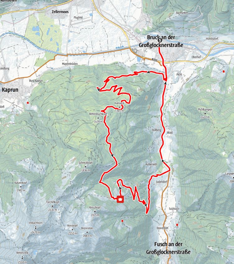
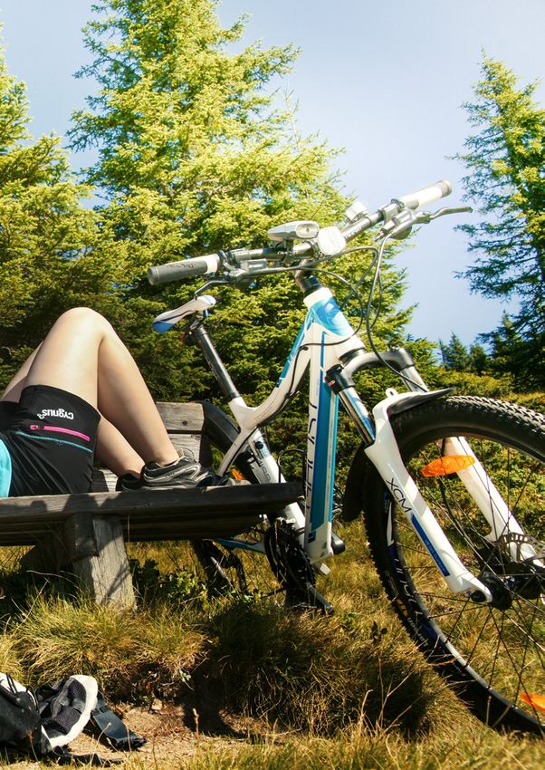
MOUNTAINBIKE TOUREN

     MOUNTAIN BIKE TOURS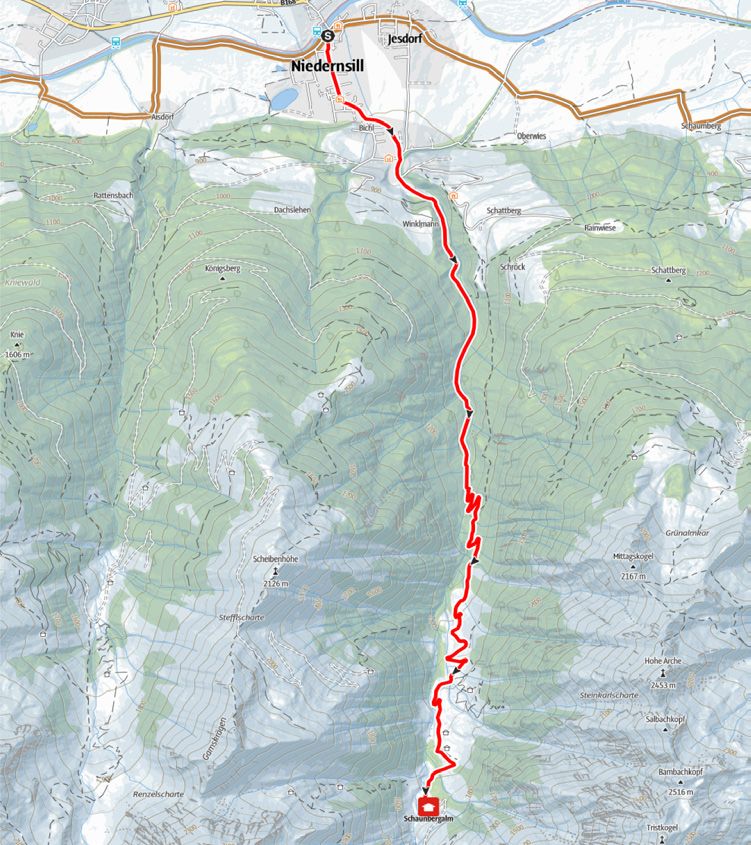
MOUNTAINBIKE TOUREN
  MOUNTAIN BIKE TOURS

  10 D   I Hochsonnbergrunde              | mittel   I medium    I 11
  9C     I Schaunbergalm Mühlbachtal      | mittel   I medium    I 13
  9D     I Klingler Törl - Hacklbergalm   | schwer I difficult   I 15
9A,10 A I Hochprackrunde                  | mittel   I medium    I 17
8C, 8G   I Sonnberg Rundtour              | mittel   I medium    I 19
9B, 10 E I Schattbergrunde                | mittel   I medium    I 21
  8H     I Uttendorfer Hochsonnbergalm    | mittel   I medium    I 23
  17A    I Hundstein                      | schwer I difficult   I 25
  17C    I Enzianhütte                    | mittel   I medium    I 27
  17 K   I Erlhofplatte                   | mittel   I medium    I 29
  11D    I Maiskogel                      | mittel   I medium    I 31
  11G    I Glocknerblick - Unterbergalm   | mittel   I medium    I 33
  11J    I Kitzsteinhorn                  | schwer I difficult   I 35
  12 E   I Erlhofalm                      | schwer I difficult   I 37
  12 F   I Bruckerberg Seeblickrunde      | mittel   I medium    I 39
10D I Hochsonnbergrunde

                                   Fahrtrichtung
                                   Driving direction

                               S   Start

                                   Berggasthof, Alm
                                   Mountain restaurant, Hut

                               N
                          11
10D I Hochsonnbergrunde
Vom Dorfplatz dem Radweg entlang der Bundesstraße bis From the village square follow the cycle path along the main
zur Walcher Kirche folgen. Nach der Kirche rechts abbiegen road to the church of Walchen. After the church turn right and
und bergauf über Skiliftstraße und Rohrerberg in Richtung ride uphill along the Skiliftstraße and Rohrerberg in direction of
Jausenstation Naglbauer. Bei der letzten Kehre vor der Jausen- Jausenstation Naglbauer. Keep right at the last bend before the
station rechts halten und weiter bis zum Mittereckbauer. Ab Jausenstation and continue to the farm Mittereck. From here the
hier beginnt der Forstweg, der Kehre um Kehre zur Hoch- forest road begins, which leads bend by bend to the Hochsonn-
sonnbergalm (10B) führt. Kurz vor der Alm rechts abzweigen bergalm (10B). Shortly before the Hochsonnbergalm turn right
und über den Höhenweg gehts bis zur Pinzgauer Hütte. Über and follow the high trail to the Pinzgauer Hütte. Return via the
Forstweg (10C) und Wengerberg retour zum Ausgangspunkt. forest path (10C) and Wengerberg back to the starting point.
Variante: Hochsonnbergalm (1.841 m) 10B -> siehe Seite 73 Variant: Hochsonnbergalm (1,841 m) 10B -> see page 73
Variante: Pinzgauer Hütte (1.700 m) 10C -> siehe Seite 73 Variant: Pinzgauer Hütte (1,700 m) 10C -> see page 73
Start: Piesendorf
Ziel: Piesendorf
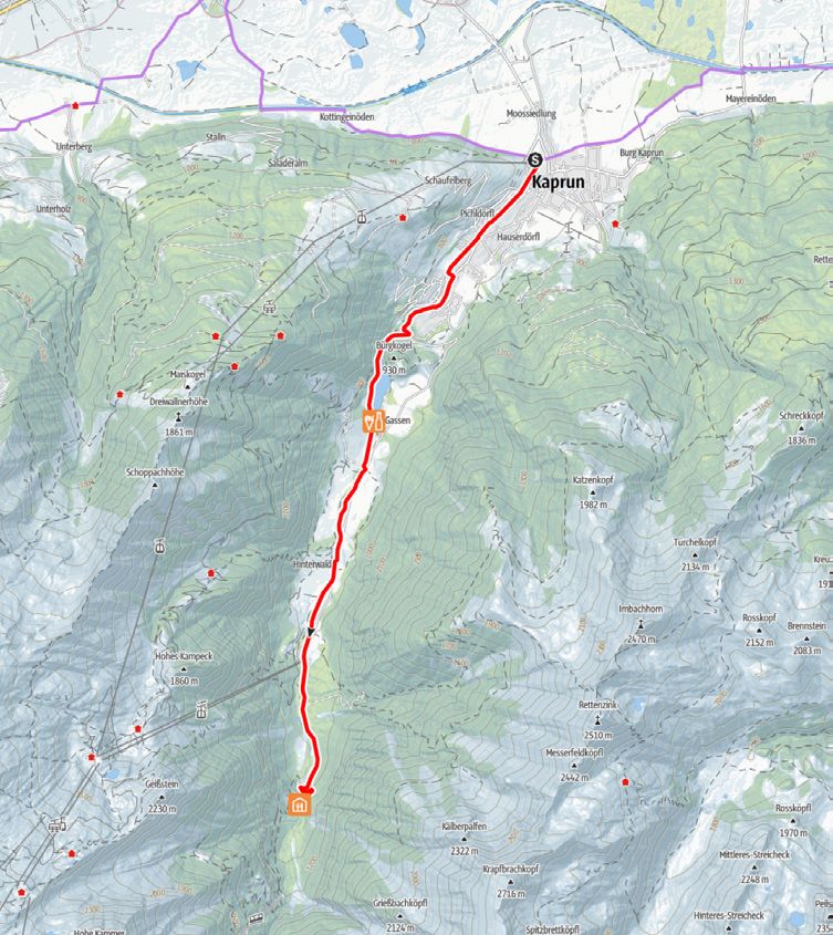
Destination: Piesendorf9C I Schaunbergalm Mühlbachtal
Fahrtrichtung
Driving direction
S Start
Berggasthof, Alm
Mountain restaurant, Hut
N
139C I Schaunbergalm Mühlbachtal
Vom Ausgangspunkt bergwärts über Dorfstraße, Schatt- From the starting point cycle upwards the Dorfstraße,
bergstraße und Winklmannweg bis zum Schranken. Weiter Schattbergstraße and Winklmannweg to the gate. From there
entlang der Forststraße bis zur Schaunbergalm auf 1.519 m. follow the forest road to the Schaunbergalm at 1,519 m.
Der Rückweg erfolgt über dieselbe Strecke. The way back is via the same route.
Start: Niedernsill
Ziel: Schaunbergalm (1.519 m)
Destination: Schaunbergalm9D I Klingler Törl - Hacklbergalm
Fahrtrichtung
Driving direction
S Start
Berggasthof, Alm
Mountain restaurant, Hut
N
159D I Klingler Törl - Hacklbergalm
Vom Ausgangspunkt über die Salzachbrücke in Richtung From the starting point, cross the Salzach bridge in the di-
Bundesstraße und durch die Unterführung in die Steindorfer rection of the main road and through the underpass into
Straße. Weiter über Gaisbichl bis Hochprack. Am Schranken Steindorfer Straße. Continue via Gaisbichl to Hochprack.
vorbei, bei der ersten Weggabelung links abbiegen und der Pass the gate, turn left at the first fork and follow the fo-
Forststraße bis kurz vor die Hochsonnberg Hütte folgen. rest road until shortly before the Hochsonnberg Hütte. Keep
Rechts halten und dem Klingler Törl Trail, übers Klingler Törl, right and follow the Klingler Törl Trail, over the Klingler
vorbei an den Hacklberger Seen bis zur Hacklbergalm folgen. Törl and past the Hacklberg lakes to the Hacklbergalm.
Für den Rückweg stehen 2 Varianten zur Auswahl: There are 2 options available for the way back:
Var. 1: über dieselbe Route zurück 1st option: via the same route back
Var. 2: als Rundtour - über Saalbach Hinterglemm, Maishofen 2nd option: as a round tour - via Saalbach Hinterglemm, Mais-
und Zell am See retour nach Niedernsill -> siehe Seite 73 hofen and Zell am See back to Niedernsill -> see page 73
Start: Niedernsill
Ziel: Hacklbergalm (1.746 m)
Destination: Hacklbergalm9A, 10 A I Hochprackrunde
Fahrtrichtung
Driving direction
S Start
Berggasthof, Alm
Mountain restaurant, Hut
N
179A, 10 A I Hochprackrunde
Vom Ausgangspunkt über die Salzachbrücke in Richtung From the starting point, cross the Salzach bridge in the
Bundesstraße und durch die Unterführung in die Steindorfer direction of the main road and through the underpass into
Straße. Weiter über Gaisbichl bis Hochprack. Am Schranken Steindorfer Straße. Continue via Gaisbichl to Hochprack. Pass
vorbei, bei der Weggabelung geradeaus und der Forststraße the gate, straight ahead at the junction and follow the forest
bis Röderlehen folgen. Von hier talwärts über Rohrerberg, path until Röderlehen. Form here downhill via Rohrerberg,
vorbei an der Jausenstation Naglbauer, nach Walchen und past the Jausenstation Naglbauer, to Walchen. Along the
übern Tauernradweg gehts wieder retour zum Startpunkt. Tauern Cycle Path return to the starting point in Niedernsill.
Die Rundtour kann auch in umgekehrter Richtung befahren The round tour can also be cycled in the opposite direction.
werden. Short Variant: via Gaisbichl - Gitschen - Naglbauer - Walchen
Verkürzte Variante: über Gaisbichl - Gitschen - Naglbauer - (see bike map)
Walchen (siehe Bike Karte)
Start: Niedernsill
Ziel: Niedernsill
Destination: Niedernsill8C, 8G I Sonnberg Rundtour
Fahrtrichtung
Driving direction
S Start
Berggasthof, Alm
Mountain restaurant, Hut
N
198C, 8G I Sonnberg Rundtour
Vom Ausgangspunkt dem gut beschilderten Tauernradweg From the starting point, follow the well-marked Tauern Cyc-
bis ins Dorfzentrum Uttendorf folgen. Vor der Dorfbrücke le Path to the centre of the village of Uttendorf. Turn right
(Scharler‘s Boutique Hotel) rechts abbiegen und bergwärts bis before the village bridge (at Scharler‘s Boutique Hotel) and
zur zweiten Weggabelung. Hier wieder rechts und über die continue uphill to the second fork in the road. Turn right
Sonnbergstraße in Richtung Pölsen. Nach der dritten Brücke again and follow the Sonnbergstraße in the direction of Pöl-
rechts abbiegen und bergab bis kurz nach einem Bauernhof. sen. After the third bridge turn right and downhill until
Hier von der asphaltierten Straße auf den Feldweg (rechts) shortly after the farm. Here change from the asphalt road
wechseln. Über diesen bis zum Bauernhof „Hacklberg“ und to the meadow path (right). Follow the path to „Hacklberg“
weiter talwärts auf der asphaltierten Straße bis Lengdorf. farm and continue downhill on the asphalt road to Lengdorf.
Die Rundtour kann auch in umgekehrter Richtung befahren The round tour can also be cycled in the opposite direction.
werden.
Start: Lengdorf
Ziel: Lengdorf
Destination: Lengdorf9B, 10 E I Schattbergrunde
Fahrtrichtung
Driving direction
S Start
Berggasthof, Alm
Mountain restaurant, Hut
N
219B, 10 E I Schattbergrunde
Vom Startpunkt bergwärts der Hummersdorfer Straße, From the starting point uphill on the Hummersdorfer Stra-
vorbei am Bauernhof „Bam“ bis zum Bauernhof „Unterholz“ ße, past the farm „Bam“ to the farm „Unterholz“. Follow
folgen. Über den beschilderten Mountainbike Weg bis zur the well-marked mountain bike path to the Jausenstation
Jausenstation Burgeck in Niedernsill. Weiter talwärts auf der Burgeck in Niedernsill. Further downhill on the Schattberg-
Schattbergstraße und Dorfstraße bis zum Tourismusver- straße and Dorfstraße to the tourist office. Continue via
band. Der Tauernradweg führt wieder retour zum Dietlgut. the Tauern Cycle Path back to the Jausenstation Dietlgut.
Die Rundtour kann auch in umgekehrter Richtung befahren The round tour can also be cycled in the opposite direction.
werden.
Start: Dietlgut (Hummersdorf)
Ziel: Dietlgut (Hummersdorf)
Destination: Dietlgut (Hummersdorf)8H I Uttendorfer Hochsonnbergalm
Fahrtrichtung
Driving direction
S Start
Berggasthof, Alm
Mountain restaurant, Hut
N
238 H I Uttendorfer Hochsonnbergalm
Vom Scharler‘s Boutique Hotel im Ortszentrum bergwärts der From Scharler‘s Boutique Hotel in the centre of the village
Dorfbachstraße bis zur zweiten Weggabelung folgen. Rechts follow the Dorfbachstraße upwards to the second junction.
abbiegen und über die Sonnbergstraße bis zur Brücke. Vor Turn right and ride along the Sonnbergstraße to the bridge.
der Brücke links abbiegen, vorbei am Keltendorf Stoanabichl Before the bridge turn left, pass the Celtic Museum Stoanabichl
und weiter bis zum Alpengasthof Liebenberg. Am Schranken and continue to Alpengasthof Liebenberg. Pass the barrier and
vorbei und der Forststraße bis zur Hochsonnbergalm folgen. follow the forest road to the Hochsonnbergalm at 1,925 m.
Der Rückweg erfolgt über dieselbe Route. The way back is via the same route.
Start: Uttendorf
Ziel: Hochsonnbergalm (1.925 m)
Destination: Hochsonnbergalm17A I Hundstein
Fahrtrichtung
Driving direction
S Start
Berggasthof, Alm
Mountain restaurant, Hut
N
2517A I Hundstein
Vom Startpunkt über Erlbergweg in Richtung Enzian- From the starting point cycle along Erlbergweg towards
hütte radeln. Nach ca. 4 km weiter auf dem Schotterweg, Enzianhütte. After about 4 km continue on the gravel path,
vorbei an der Enzianhütte bis zur Erlhofplatte. Hier links past the Enzianhütte to the Erlhofplatte. Keep left and follow
halten und der Beschilderung steil bergauf in Richtung the signs steeply upwards in the direction of Hundstein until
Hundstein bis nach einem Brunnen, wo der Forstweg merk- after a waterwell, where the forest road flattens out. After the
lich abflacht, folgen. Nach der Kurve, von der man den bend, from which you can see the summit, the single trail passage
Gipfel sieht, beginnt die Single Trail-Passage. Vorsicht: begins. Caution: technically very demanding! On this trail you
technisch sehr anspruchsvoll! Auf diesem umrundet man circle the mountain and come to the forest road which leads
den Berg und kommt zum Forstweg, der von Maria Alm up from Maria Alm. Follow the road uphill to the Statzerhaus.
hochführt. Diesem bergwärts bis zum Statzerhaus folgen.
Der Rückweg erfolgt über dieselbe Route. Eine Abfahrt nach The way back is via the same route. A descent to Maria Alm or
Maria Alm oder Bruck ist ebenfalls möglich. Bruck is also possible.
Start: Thumersbach
Ziel: Statzerhaus - Hundstein (2.117 m)
Destination: Statzerhaus - Hundstein17C I Enzianhütte
Fahrtrichtung
Driving direction
S Start
Berggasthof, Alm
Mountain restaurant, Hut
N
2717C I Enzianhütte
Von Thumersbach bergwärts der Talstraße bis zum Gasthof From Thumersbach follow the Talstraße upwards to the
Waldheim folgen. Kurz danach rechts abbiegen und bergauf Gasthof Waldheim. Shortly afterwards turn right and ride
bis zur fünften Kehre (Abzweigung Enzianhütte) radeln. Ab uphill to the fifth bend (junction Enzianhütte). From here take
hier über den markierten Weg bis zur Enzianhütte (1.300 m). the marked path to the Enzianhütte (1,300 m). Now follow
Talwärts über Erlbergweg und retour zum Ausgangspunkt. the Erlbergweg downhill and cycle back to the starting point.
Die Rundtour kann auch in umgekehrter Richtung befahren The round tour can also be cycled in the opposite direction.
werden.
Start: Thumersbach
Ziel: Thumersbach
Destination: Thumersbach17K I Erlhofplatte
Fahrtrichtung
Driving direction
S Start
Berggasthof, Alm
Mountain restaurant, Hut
N
2917K I Erlhofplatte
Vom Ausgangspunkt in Richtung Gasthof Lukashansl und From the starting point ride in the direction of Gasthof
gleich nach der Brücke rechts abbiegen. Kurz danach links Lukashansl, immediately after the bridge turn right. Shortly
weiter, die Tour steigt in Richtung Taxhof und Erlhofplatte after, turn left and continue upwards towards Taxhof
an. Der Beschilderung 12A bis zur Abzweigung Hundstein and Erlhofplatte. Follow the signs 12A to the Hundstein
folgen. Vom höchsten Punkt der Tour talwärts, vorbei am junction. Downhill from the highest point of the tour,
Bauernhof „Ronachbauer“ bis zur Enzianhütte und weiter pass the farm „Ronachbauer“ to the Enzianhütte and
talwärts nach Thumersbach. Entlang vom Zeller See in further down to Thumersbach. Along the lake Zell in
südliche Richtung wieder retour zum Startpunkt in Bruck. southern direction cycle back to the starting point in Bruck.
Die Rundtour kann auch in umgekehrte Richtung befahren The round tour can also be cycled in the opposite direction.
werden.
Start: Bruck
Ziel: Bruck
Destination: Bruck11D I Maiskogel
Fahrtrichtung
Driving direction
S Start
Berggasthof, Alm
Mountain restaurant, Hut
N
3111D I Maiskogel
Von der MK Maiskogelbahn dem Radweg durch den Tunnel From the MK Maiskogel cable car, follow the cycle path
bis zur Abzweigung Schaufelbergstraße folgen. Rechts through the tunnel to the junction of the Schaufelberg-
abbiegen und bergwärts, vorbei an der Jausenstation Unter- straße. Turn right and cycle upwards past the Jausen-
aigen in Richtung Stangerbauer. Kurz davor wieder rechts station Unteraigen in the direction of Stangerbauer. Shortly
abbiegen und über den Maiskogelweg, vorbei an der Mittel- before, turn right again and cycle along Maiskogelweg, past
station der Gondelbahn weiter bis zur Maiskogel Alm Ranch. the mid-station of the cable car to the Maiskogel Alm Ranch.
Der Rückweg erfolgt über dieselbe Route. The way back is via the same route.
Start: MK Maiskogelbahn
Ziel: Maiskogel Alm Ranch (1.544 m)
Destination: Maiskogel Alm Ranch11G I Glocknerblick - Unterbergalm
Fahrtrichtung
Driving direction
S Start
Berggasthof, Alm
Mountain restaurant, Hut
N
3311G I Glocknerblick - Unterbergalm
Von der MK Maiskogelbahn dem Radweg durch den Tunnel From the MK Maiskogel cable car, follow the cycle path
bis zur Abzweigung Schaufelbergstraße folgen. Rechts abbie- through the tunnel to the junction of the Schaufelberg-
gen und bergwärts, vorbei an der Jausenstation Unteraigen in straße. Turn right and cycle upwards past the Jausenstation
Richtung Stangerbauer. Bei der letzten Kehre an der rechten Unteraigen in the direction of Stangerbauer. At the last bend
Seite den Schranken passieren und dem gut markierten Weg on the right side pass the barrier and follow the well-marked
bis zur Saulochalm folgen. Ca. 50 m nach der Alm entweder path to the Saulochalm. About 50 m after the hut turn
rechts weiter zur Unterbergalm (1.562 m - ca. 1,5 km) oder links right to the Unterbergalm (1,562 m - approx. 1.5 km) or turn
weiter zum Alpengasthaus Glocknerblick (1.659 m - ca. 1 km). left to Alpengasthaus Glocknerblick (1,659 m - approx. 1 km).
Der Rückweg erfolgt über dieselbe Route oder über Weg Nr. The way back is via the same route or via the path no. 11D, past
11D, vorbei an der Maiskogel Alm Ranch. the Maiskogel Alm Ranch.
Start: MK Maiskogelbahn
Ziel: Glocknerblick, Unterbergalm
Destination: Glocknerblick, Unterbergalm11J I Kitzsteinhorn
Fahrtrichtung
Driving direction
S Start
Berggasthof, Alm
Mountain restaurant, Hut
N
3511J I Kitzsteinhorn
Von der MK Maiskogelbahn dem Radweg durch den From the MK Maiskogel cable car, follow the cycle path through
Tunnel bis zur Abzweigung Schaufelbergstraße folgen. the tunnel to the junction of the Schaufelbergstraße. Turn right
Rechts abbiegen und bergwärts, vorbei an der Jausensta- and cycle upwards past the Jausenstation Unteraigen in the
tion Unteraigen in Richtung Stangerbauer. Bei der letzten direction of Stangerbauer. At the last bend on the right pass
Kehre an der rechten Seite den Schranken passieren und the barrier and follow the well-marked path to the mountain
dem gut markierten Weg bis zur Bergstation der Gondel- station of the cable car. Continue to the Maiskogel Alm Ranch,
bahn folgen. Weiter zur Maiskogel Alm Ranch, von hier kurz from here begins a short downhill to the Ederalm at 1,420 m.
bergab zur urigen Ederalm auf 1.420 m. Danach steigt der Then the path leads upwards, pass the Salzburger Hütte and over
Weg, dieser führt vorbei an der Salzburger Hütte und über Langwiedboden to the Alpincenter at 2,450 m above sea level.
Langwiedboden bergauf bis zum Alpincenter auf 2.450 m.
Der Rückweg erfolgt über dieselbe Strecke. Talfahrt mit der The way back is via the same route. A descent with the cable car
Gondelbahn ebenso möglich! is also possible.
Start: MK Maiskogelbahn
Ziel: Alpincenter Kitzsteinhorn (2.450 m)
Destination: Alpincenter Kitzsteinhorn12 E I Erlhofalm
Fahrtrichtung
Driving direction
S Start
Berggasthof, Alm
Mountain restaurant, Hut
N
3712 E I Erlhofalm
Von Bruck dem gut beschilderten Tauernradweg in From Bruck follow the well-marked Tauern Cycle Path
Richtung Taxenbach folgen. Nach ca. 3 km bei Nieder- in the direction of Taxenbach. After about 3 kilometres
hof rechts abbiegen. Ab hier Kehre um Kehre und ent- turn right at Niederhof. From here, the path continues up-
lang der Beschilderung stets bergauf bis zur Erlhofalm. hill, bend after bend and along the signs to the Erlhofalm.
Der Rückweg erfolgt über dieselbe Route. The way back is via the same route.
Start: Bruck
Ziel: Erlhofalm (1.653 m)
Destination: Erlhofalm
Nicht bewirtschaftet I not managed12 F I Bruckerberg Seeblickrunde
Fahrtrichtung
Driving direction
S Start
Berggasthof, Alm
Mountain restaurant, Hut
N
3912 F I Bruckerberg Seeblickrunde
Vom Startpunkt für ca. 1 km der Glocknerstraße Rich- From the starting point follow the Glocknerstraße for about
tung Fusch folgen. Bei Straßenkilometer 1,3 (zwischen den 1 km in the direction of Fusch. At road kilometre 1.3 (between the
Häusern) rechts abbiegen und bergwärts entlang der Be- houses) turn right and cycle upwards along the mountain bike
schilderung Richtung Bruckerberg. Nach wenigen Metern signs towards Bruckerberg. After a few metres the gravel road
beginnt die Schotterstraße, über diese bei gleichmäßiger begins, over this road you cycle on a steady ascent to the
Steigung bis zum höchsten Punkt der Tour. Von der Ab- highest point of the tour. From the Reiteralm turn-off, it‘s a
zweigung Reiteralm kurz bergab, den Wachtbergbach über- short descent and over the Wachtbergbach (stream), then you
queren und nochmals gut 100 hm bergauf. Über den kurzen cycle another 100 m uphill. From here downhill over the short,
technisch nicht ganz einfachen Single Trail weiter talwärts technically not very easy single trail to the Ponyhofalm and on
zur Ponyhofalm und über den Güterweg nach Juden- to Judendorf. Along the cycle path back to the starting point.
dorf. Dem Radweg talauswärts zum Ausgangspunkt folgen.
Start: Bruck
Ziel: Bruck
Destination: BruckTREKKING & E-BIKE TOUREN
TREKKING & E-BIKE TOURS
5
12 F I Bruckerberg SeeblickrundeTREKKING & E-BIKE TOUREN TREKKING & E-BIKE TOURS E3 I Tauernradweg Salzachtal | leicht I easy I 43 E4 I Tauernradweg Saalachtal | leicht I easy I 45 8D I Panoramastraße Stubachtal | mittel I medium I 47 11C I Kesselfall | leicht I easy I 49 E1 I Zeller Seerunde | leicht I easy I 51
E3 I Tauernradweg Salzachtal

                                        Fahrtrichtung
                                        Driving direction

                                    S   Start

                                        Berggasthof, Alm
                                        Mountain restaurant, Hut

                                    N
                               43
E3 I Tauernradweg Salzachtal
Ausgangspunkt der Tour sind die Krimmler Wasserfälle, Starting point of the tour are the Krimml Waterfalls, because
denn das ist eine einfachere Variante, da die Tour bergab this is an easier variant, as the tour runs downhill. From
verläuft. Von hier dem gut beschilderten Tauernradweg here follow the well-marked Tauern Cycle Path along the
entlang der Salzach, durch die vielen Ortschaften des Salzach, through the many villages of the Oberpinzgau such
Oberpinzgaues wie z.B. Bramberg, Mittersill, Niedernsill, as Bramberg, Mittersill, Niedernsill, Piesendorf to Bruck
Piesendorf bis Bruck an der Glocknerstraße folgen. Die Tour an der Glocknerstraße. The tour continues via Taxenbach,
führt weiter über Taxenbach, Werfen, Golling bis nach Salz- Werfen, Golling to Salzburg. On the cycle path you will pass
burg. Auf dem Radweg kommt man an vielen beeindrucken- many impressive sights which invites you to marvel at them.
den Sehenswürdigkeiten vorbei, die zum Bestaunen einladen.
Den Tauernradweg kann man in Etappen und von jedem Ort The Tauern Cycle Path can be cycled in stages and from any
aus fahren. Eine Weiterfahrt nach Passau ist möglich! village. It is also possible to continue on to Passau.
Start: Krimml
Ziel: Salzburg
Destination: SalzburgE4 I Tauernradweg Saalachtal
Fahrtrichtung
Driving direction
S Start
Berggasthof, Alm
Mountain restaurant, Hut
N
45
5E4 I Tauernradweg Saalachtal
Die Tour startet in Niedernsill und führt entlang am gut The tour starts in Niedernsill and leads along the
markierten Tauernradweg über Kaprun bis Bruck an der well-marked Tauern Cycle Path via Kaprun to Bruck an der
Glocknerstraße und von hier Richtung Schüttdorf, durch die Glocknerstraße and from here towards Schüttdorf, through
Porsche Allee und an der Seepromenade bis zum Yachthafen the Porsche Allee and along the lakeside promenade to the
am Zeller See. Links abbiegen und dem Straßenverlauf, marina at lake Zell. Turn left and follow the road, past
vorbei am Schloß Prielau, durch Maishofen und über Gerling the Prielau Castle, through Maishofen and via Gerling to
bis Saalfelden folgen. Ab hier verläuft der Tauernradweg ent- Saalfelden. From here the cycle path runs along the Saalach
lang der Saalach durch die Orte Weißbach, St. Martin, Lofer, river through the villages of Weißbach, St. Martin, Lofer,
über das „Kleine Deutsche Eck“ und Großgmain bis Salzburg. via the „Kleines Deutsche Eck“ and Großgmain to Salzburg.
Den Tauernradweg kann man in Etappen und von jedem Ort The Tauern Cycle Path can be cycled in stages and from any
aus fahren. Eine Weiterfahrt nach Passau ist möglich! village. It is also possible to continue on to Passau.
Start: Niedernsill
Ziel: Salzburg
Destination: Salzburg8D I Panoramastraße Stubachtal
Fahrtrichtung
Driving direction
S Start
Berggasthof, Alm
Mountain restaurant, Hut
N
47
58D I Panoramastraße Stubachtal
Vom Ausgangspunkt entlang der Stubachstraße ins From the starting point follow the Stubachstraße into the
Stubachtal bis zur Schneiderau folgen. Ab hier beginnt Stubachtal until you reach the Schneiderau. From here
der anspruchsvollere Teil der Tour. Kehre um Kehre the more demanding part of the tour begins. Bend after
gehts über die Panoramastraße bis zum Enzingerboden. bend you follow the panorama road to the Enzingerboden.
Der Rückweg erfolgt über dieselbe Route. The way back is via the same route.
Hinweis! Die Panoramastraße Stubachtal ist auch eine sehr Notice! The panorama road Stubachtal is also a very popular
beliebte Tour für Rennradfahrer. tour for racing cyclist.
Start: Uttendorf
Ziel: Enzingerboden (1.468 m)
Destination: Enzingerboden11C I Kesselfall
Fahrtrichtung
Driving direction
S Start
Berggasthof, Alm
Mountain restaurant, Hut
N
49
511C I Kesselfall
Von der Talstation der MK Maiskogelbahn dem Radweg From the valley station of the MK Maiskogel cable car fol-
durch den Tunnel, entlang vom Wiesenweg bis zur Pichel- low the cycle path through the tunnel, along the Wiesenweg
brücke und weiter zur Nindlbrücke folgen. Links in die to the Pichel bridge and further to the Nindl bridge. Turn left
Nikolaus Gassner Straße einbiegen, vorbei am Gasthof zur into Nikolaus Gassner Straße, past Gasthof zur Mühle and
Mühle und am Hotel Falkenstein. An der Kreuzung über die Hotel Falkenstein. At the crossroads along the Kesselfallstra-
Kesselfallstraße bis zur Villa Burg und in den Klammweg ße to Villa Burg and turn into Klammweg. Now cycle uphill,
abbiegen. Nun gehts bergauf, über die Belinsky-Brücke und over the Belinsky bridge and past the Sigmund-Thun gorge to
vorbei an der Sigmund-Thun-Klamm bis zum Klamm- the Klammsee. Follow the Uferstraße to the Au bridge. Cross
see. Über den Uferweg bis zur Aubrücke. Diese überque- the bridge and turn right onto the cycle path into the val-
ren und rechts dem taleinwärts führenden Radweg, an der ley, past the glacier cable car and onto Alpenhaus Kesselfall.
Gletscherbahn vorbei, bis zum Alpenhaus Kesselfall folgen.
Der Rückweg erfolgt über dieselbe Route. The way back is via the same route.
Start: MK Maiskogelbahn
Ziel: Alpengasthaus Kesselfall (1.034 m)
Destination: Alpengasthaus KesselfallE1 I Zeller Seerunde
Fahrtrichtung
Driving direction
S Start
Berggasthof, Alm
Mountain restaurant, Hut
N
51
5E1 I Zeller Seerunde
Vom Startpunkt dem gut beschilderten Tauernradweg bis From the starting point, follow the well-marked Tauern Cyc-
Bruck und links weiter bis zum Zeller See. Auf der Seepro- le Path to Bruck and turn left to the Lake Zell. Along the
menade und der Uferstraße ist es möglich, den Zeller See lake shore and the Uferstraße, it is possible to around the
komplett zu umrunden. Der Westteil der Promenade ver- Lake Zell. The western part of the promenade goes straight
läuft fast ausschließlich direkt neben dem Seeufer. Der öst- along the lake, the eastern part leads along the Seeuferstrasse.
liche Teil der Promenade führt entlang der Seeuferstraße.
Der Rückweg erfolgt wieder über den Tauernradweg. The way back is along the Tauern Cycle Path.
Tipp! Ein Abstecher zum Pfefferbauer über Radweg Nr. 17D Tip! A detour to the Pfefferbauer via cycle path no. 17D is very
ist sehr lohnenswert, um das einzigartige Berg- und Seeblick worthwhile to enjoy the unique mountain and lake panorama
Panorama auf den Zeller See und die Bergwelt zu genießen. of the Lake Zell and the surrounding mountain world.
Start: Niedernsill
Ziel: Niedernsill
Destination: NiedernsillFREERIDE TRAILS
FREERIDE TRAILS

F1   I Bachler Trail     | mittel   I medium    I 55
F2   I Wüstlau Trail     | schwer I difficult   I 57
F3   I Geißstein Trail   | mittel   I medium    I 59
F1 I Bachler Trail

                              Fahrtrichtung
                              Driving direction

                          S   Start

                              Berggasthof, Alm
                              Mountain restaurant, Hut
                          N

                     55
F1 I Bachler Trail
Der Startpunkt vom naturbelassenen Trail mit flowi- The starting point of this natural trail with flowing terrain and
gem Gelände und weiten Kurven wird nach einer kur- wide curves is reached after a short descent from Maiskogel or
zen Abfahrt vom Maiskogel oder über einen kurzen An- a short ascent from Langwiedboden. The trail continues via
stieg vom Langwiedboden erreicht. Ab hier gehts über Schneckenreith down to the picturesque Klammsee Reservoir.
Schneckenreith hinunter zum malerischen Klammsee.
Für diesen Trail wird ein Uphill-taugliches Bike empfohlen. A bike suitable for uphilling is recommended for this trail.
Start: Astenweg (Kehre 4)
Ziel: Klammsee
Destination: KlammseeF2 I Wüstlau Trail
Fahrtrichtung
Driving direction
S Start
Berggasthof, Alm
Mountain restaurant, Hut
N
57
5F2 I Wüstlau Trail
Vom Langwiedboden bis ins Tal hinunter führt der Wüstlau The Wüstlau Trail leads on 7.7 kilometres and an amazing
Trail mit sagenhaften 7,7 Kilometern Länge und über 1.000 more than 1,000 altitude metres from the Langwiedboden
Höhenmetern. Hier sind Ausdauer und Können gefragt, downhill into the valley. Stamina and skills are required here.
denn der extralange Trail führt über Almböden mit top- Freeriders must master alpine pasture ground, root-covered
geshapten Anliegern, durch wurzelige und steinige Wald- and rocky forest passages and one or the other hairpin
passagen und auch die eine oder andere Spitzkehre ist im bend in the steep section on this extra-long trail. Fast pass-
Steilstück zu bewältigen. Schnelle Passagen wechseln mit ages alternate with technical demanding sequences. In the
technisch anspruchsvollen Sequenzen. Im unteren Bereich lower area it follows the natural course of the hiking trail.
verläuft er über den natürlichen Verlauf des Wanderweges.
Start: Langwiedboden
Ziel: Wüstlau
Destination: WüstlauF3 I Geißstein Trail
Fahrtrichtung
Driving direction
S Start
Berggasthof, Alm
Mountain restaurant, Hut
N
59
5F3 I Geißstein Trail
Den Einstieg in den Trail erreicht man bequem mit der The start of this trail you reach comfortably by the cable car.
Gondelbahn. 467 Höhenmeter überwindet man auf diesem 467 altitude metres must be conquered on this 3-kilometre-long
über 3 Kilometer langen hochalpinen Trail mit Startpunkt high alpine trail with starting point at the Alpincenter 2,450 m
beim Alpincenter auf 2.450 m Seehöhe. Mit Geschwin- above sea level. The banked curves are taken at a racy pace and
digkeit geht es durch die Anlieger und der Trail ist mit smaller jumps cover the trail. The Geißstein Trail ends at the
kleineren Sprüngen gespickt. Am Langwiedboden endet der Langwiedboden - but merges directly with the Wüstlau Trail.
Geißstein Trail - mündet aber direkt in den Wüstlau Trail ein.
Start: Alpincenter Kitzsteinhorn
Ziel: Langwiedboden
Destination: LangwiedbodenRENNRAD TOUREN
ROAD BIKE TOURSRENNRAD TOUREN ROAD BIKE TOURS R1 I Großglockner Tour | schwer I difficult I 63 R2 I Kitzbüheler Runde | schwer I difficult I 65 R3 I Filzensattel Runde | mittel I medium I 67 R4 I Pillersee Runde | schwer I difficult I 69
R1 I Großglockner Tour

                                  Fahrtrichtung
                                  Driving direction

                              S   Start

                                  Berggasthof, Alm
                                  Mountain restaurant, Hut
                              N

                         63
R1 I Großglockner Tour
Vom Ausgangspunkt dem Tauernradweg bis Bruck From the starting point follow the well-marked Tauern Cyc-
folgen. Von hier weiter ins Fuschertal. In Fusch be- le Path to Bruck. From here continue into the Fuschertal.
ginnt der Hauptanstieg, vorbei am Wild- & Erlebnis- The main ascent begins in Fusch, past the wildlife & adven-
park Ferleiten bis zur Mautstelle. Nun gehts entlang der ture park Ferleiten to the toll station. Now you follow up-
aussichtsreichen Panoramastraße hinauf bis zum höchs- wards the panoramic road with its beautiful views to the
ten Punkt der Gebirgsstraße, die Edelweißspitze (2.571 m). highest point of the high alpine road, the Edelweißspitze (2,571 m).
Der Rückweg erfolgt über dieselbe Route. The way back is via the same route.
Für Konditionsstarke: Weiterfahrt übers Fuschertörl und For very fit racing bikers: It is possible to continue via Fuscher-
dem Hochtor bis zur Kaiser-Franz-Josefs-Höhe (2.369 m) törl and Hochtor to the Kaiser-Franz-Josefs-Höhe (2,369 m)
und/oder nach Heiligenblut (Kärnten) möglich! and/or to Heiligenblut (Kärnten).
Start: Niedernsill
Ziel: Niedernsill
Destination: NiedernsillR2 I Kitzbüheler Runde
Fahrtrichtung
Driving direction
S Start
Berggasthof, Alm
Mountain restaurant, Hut
N
65R2 I Kitzbüheler Runde
Vom Startpunkt dem Tauernradweg über Kaprun bis zum From the starting point follow the Tauern Cycle Path via
Brückenwirt folgen. Auf der Kaprunerstraße bis nach Schütt- Kaprun to Brückenwirt. Further along the Kaprunerstraße
dorf. Durch Schüttdorf durch und entlang der Seepromenade to Schüttdorf. Through Schüttdorf and along the lake shore
nach Maishofen und weiter nach Saalfelden. Von Saalfelden to Maishofen and on to Saalfelden. From Saalfelden via
über Leogang, Grießenpass, Hochfilzen, Fieberbrunn nach Leogang, Grießenpass, Hochfilzen, Fieberbrunn to St. Johann
St. Johann in Tirol. Über Oberndorf, Kitzbühel, Aurach, und in Tyrol. Over Oberndorf, Kitzbühel, Aurach and
Jochberg auf den Pass Thurn (1.285 m). Jetzt gehts bergab für Jochberg ascend the Pass Thurn (1,285 m). Now it runs down-
ca. 10 km nach Mittersill und retour zum Ausgangspunkt. hill for about 10 km to Mittersill and back to the starting point.
Die Runde kann auch in umgekehrter Richtung befahren The round tour can also be cycled in the opposite direction.
werden.
Start: Niedernsill
Ziel: Niedernsill
Destination: NiedernsillR3 I Filzensattel Runde
Fahrtrichtung
Driving direction
S Start
Berggasthof, Alm
Mountain restaurant, Hut
N
67R3 I Filzensattel Runde
Vom Startpunkt entlang dem Tauernradweg oder der Bundes- From the starting point follow the Tauern Cycle Path or the
straße (B168) bis Bruck folgen. Weiter in östliche Richtung major road (B168) until Bruck. Continue in eastern direction
(B311) über Taxenbach bis Lend. Hier beginnt der Anstieg (B311) via Taxenbach to Lend. Here the ascent to Filzensat-
zum Filzensattel, wobei man dem Lauf des Dientener Baches tel begins, how you take the course of the Dientener stream in
in nördliche Richtung folgt. Im Angesicht des Hochkönigs northern direction. In the view of the Hochkönig, you climb the
erklimmt man die Passhöhe auf 1.290 m. Über den Sattel pass at 1,290 m. The well-developed Hochkönigsstraße (B164)
führt die gut ausgebaute Hochkönigsstraße (B164) mit nur leads over the pass with only a few narrow passages. From
wenigen Engstellen. Von der Passhöhe gehts hinunter nach here you downhill to Hinterthal - Maria Alm and on to Saal-
Hinterthal - Maria Alm und weiter nach Saalfelden. Kurz felden. Shortly after Schinking turn left and via Gerling, Mais-
nach Schinking links abbiegen und über Gerling, Maisho- hofen, Zell am See and Kaprun return to your starting point.
fen, Zell am See und Kaprun retour zum Ausgangspunkt.
Die Runde kann man auch in umgekehrter Richtung fahren. The round tour can also be cycled in the opposite direction.
Start: Niedernsill
Ziel: Niedernsill
Destination: NiedernsillR4 I Pillersee Runde
Fahrtrichtung
Driving direction
S Start
Berggasthof, Alm
Mountain restaurant, Hut
N
69
5R4 I Pillersee Runde
Vom Startpunkt nach Zell am See und über Maishofen nach From the starting point you cycle to Zell am See and via Mais-
Saalfelden. Von hier weiter nach Leogang, über Hochfilzen, hofen to Saalfelden. From here on to Leogang, via Hochfilzen,
St. Ulrich, Waidring bis nach Lofer. (Radweg in Leogang recht St. Ulrich am Pillersee, Waidring to Lofer. (Cycle path in Leo-
verwinkelt - alternativ über die Bundesstraße. Von Hochfil- gang is quite windy - alternative you cycle via the main road.
zen bis Lofer geht es meist auf ruhigen Nebenstraßen zügig From Hochfilzen to Lofer, the route is mostly on quiet side ro-
voran - Radweg zum Teil nicht rennradtauglich!) Ab Lofer ads - cycle path partly not suitable for racing bikes!) From Lofer
entlang dem gut asphaltierten Tauernradweg bis Saalfelden, cycle along the well asphalted Tauern Cycle Path to Saalfelden
über Maishofen und Zell am See retour zum Ausgangspunkt. and via Maishofen and Zell am See back to the starting point.
Die Runde kann auch in umgekehrte Richtung befahren The round tour can also be cycled in the opposite direction.
werden.
Start: Niedernsill
Ziel: Niedernsill
Destination: NiedernsillWEITERE TOUREN
FURTHER TOURSWEITERE TOUREN
FURTHER TOURS
10 B I Hochsonnberg Alm | mittel I medium I 73
10 C | Pinzgauer Hütte | mittel I medium I 73
| Rundtour: Niedernsill Saalbach | schwer I difficult I 73
17 I I Mitterberg | mittel I medium I 74
11 I | Maiskogel - Bachler Trail | mittel I medium I 74
11M | Lechnerberg | mittel I medium I 74
11B | Schneckenberg | schwer I difficult I 75
K1, K2 I Weltcuprunde | schwer I difficult I 75
13B I Sulzbachtal | mittel I medium I 76
13C | Bad Fusch - Embach Hochalm | mittel I medium I 76
13 D | Trauneralm | mittel I medium I 76
12 B | Kohlschnait | mittel I medium I 77
12 D | Moosalm | mittel I medium I 77PIESENDORF NIEDERNSILL
10 B I Hochsonnberg Alm mittel I medium
Start: Walchen
Ziel | destination: Hochsonnberg Alm
Nach der Kirche rechts abbiegen, über After the church turn right, via Skiliftstraße
Skiliftstraße und Rohrerberg in Richtung and Rohrerberg towards to the Jausen-
Jausenstation Naglbauer. Bei der letzten station Naglbauer. At the last bend before
Kehre vor Naglbauer rechts abbiegen, Naglbauer turn right, further on to the
weiter bis zum Mittereckbauer. Bergwärts Mittereck farm. Follow upwards the forest
73
der Forststraße bis zum Zielpunkt folgen. path to the destination - Hochsonnberg Alm.
10 C I Pinzgauer Hütte mittel I medium
Start: Piesendorf
Ziel | destination: Pinzgauer Hütte
An der Kirche vorbei, rechts abbiegen. Pass the church, turn right. Via Wengerberg
Über Wengerberg bis zum Schranken, to the barrier. From here follow the forest
entlang der Forststraße bis zum Ziel. road to your destination - Pinzgauer Hütte.
Rundtour: Niedernsill Saalbach schwer I difficult
Start: Niedernsill
Ziel | destination: Niedernsill
Von Niedernsill via Gaisbichl, Hoch- From Niedernsill via Gaisbichl, Hochprack
prack bis zur Hochsonnberg Hütte und to the Hochsonnberg Hütte and on via
über Klingler Törl Trail bis Hacklbergalm. Klingler Törl Trail to Hacklbergalm.
3 Varianten zur Abfahrt nach Hinter- 3 options for the descent to Hinter-
glemm: Forstweg (76-mittel), Huber glemm: Forest path (76-medium), Huber
Hochalm (76-schwer) oder Bergstadl (04- Hochalm (76-difficult) or Bergstadl (04-
leicht). Von Hinterglemm über Glemmtal easy). From Hinterglemm via Glemmtal
Radweg nach Maishofen und entlang am Cycle Path to Maishofen and along the
Tauernradweg retour nach Niedernsill. Tauern Cycle Path back to Niedernsill.ZELL AM SEE-KAPRUN
17 I I Mitterberg mittel I medium
Start: Thumersbach
Ziel | destination: Gasthof Mitterberg
Abfahrt Ortsteil Thumersbach, bei der Depart centre of Thumersbach, turn up
Kapelle bergwärts abbiegen, bis zur Ab- the mountain at the chapel and ride to the
zweigung Mitterberg. Links abbiegen und Mitterberg turn off. Turn left and follow
der kurvigen Strecke bis zum Ziel folgen. upwards the curves to the destination.
11 I I Maiskogel - Bachler Trail mittel I medium
Start: MK Maiskogelbahn
Ziel | destination: MK Maiskogelbahn
Vom Start durch den Tunnel bis Abzwei- From the valley station through the tunnel to
gung Schaufelbergstraße. Dem Weg Rich- the Schaufelbergstraße junction. Follow the
tung Stangerbauer folgen, weiter bis zur road towards Stangerbauer and continue to
Maiskogel Alm Ranch. Über Astenweg, the Maiskogel Alm Ranch. Via Astenweg,
Bachler Trail, Schneckenbauer bis zur Bachler Trail, Schneckenbauer to the Au-
Aubrücke und via Tauernradweg retour. brücke and back via the Tauern cycle path.
11M I Lechnerberg mittel I medium
Start: MK Maiskogelbahn
Ziel | destination: MK Maiskogelbahn
Vom Start bis zum Kaufhaus Neumaier, hier From the start to Kaufhaus Neumaier, turn
links über die Brücke. Weiter bis Abzwei- left and cross the bridge. Continue to the
gung Peter Buchner Straße. Am Ende der junction Peter Buchner street. At the end of
P. B. Straße rechts in den Lechnerbergweg. P. B. street turn right into Lechnerbergweg.
Bergauf bis zur Radfahrverbotstafel. Links Cycle uphill until you reach the „no cycling
weiter, vorbei an Bergstation Lechner- sign“. Continue left, past the Lechnerberg-
berglift und über Holzzieherweg bis zum lift top station and via Holzzieherweg to
Lechnerberg Weg. Retour zum Startpunkt. the Lechnerberg road. Return to the start.ZELL AM SEE-KAPRUN
11B I Schneckenberg schwer I difficult
Start: MK Maiskogelbahn
Ziel | destination: Schneckenberg
Vom Start rechts in Sigmund Thun Straße Turn at the MK Maiskogel cable car right
abbiegen und geradeaus bis zur Brücke. in the Sigmund Thun street, straight ahe-
Die Brücke überqueren, entlang der Ni- ad to the bridge. Cross the bridge, via Ni-
kolaus Gassner Straße bis zur Kreuzung kolaus Gassner street to the Winklhofweg
Winklhofweg. Links und über Holzbrücke junction. Turn left and over the wooden
75
bis zum 1. Überstieg. Nach 50 m rechts bridge to the 1st climb. Turn right after
und geradeaus bis zur Kesselfallstraße. 50 m, follow straight ahead to Kesselfallstra-
Weiter bis zur Aubrücke am Klammsee. ße. Further to Aubrücke at Klammsee. Right
Rechts über die Brücke und bergauf bis over the bridge and upwards to the Jausen-
zur Jausenstation Schneckenreith. Vor station Schneckenreith. Before the house
dem Haus stark bergauf Richtung Schne- cycle upwards in the direction Schnecken-
ckenberg. Mehrere Serpentinen bergwärts berg. Several steep serpentine bends lead
bis zum Ende der Tour (Viehunterstand). to the end of the tour (last animal shelter).
11K1/ K2 I Weltcuprunde schwer I difficult
Start: Tourismusinformation Kaprun
Ziel | destination: Information Kaprun
Von Kaprun bergwärts dem gut beschil- From Kaprun ride upwards the well-mar-
derten Güterweg bzw. der Forststra- ked road and forest road via Maiskogel
ße übern Maiskogel bis zur Maiskogel to the Maiskogel Alm Ranch. From here
Alm Ranch folgen. Von hier talwärts am downhill on the Astenweg and Bachler
Astenweg und Bachler Trail (technisch Trail (technically demanding single trail)
anspruchsvoller Single Trail) bis zur to the Jausenstation Schneckenreith. Con-
Jausenstation Schneckenreith. Weiter ent- tinue along the Cross Country Course
lang auf dem Cross Country Kurs über over short but very steep climbs before you
kurze aber giftige Anstiege bis kurz bevor reach Kaprun Castle. Turn off into the
Burg Kaprun. Hier ins Kapruner Land- Kaprun landscape conservation area
schaftsschutzgebiet abbiegen und ent- and ride gently along the banks of the
lang der Salzach retour zum Startpunkt. Salzach river back to the starting point.BRUCK FUSCH
13 B I Sulzbachtal mittel I medium
Start: Tauernradweg Fusch
Ziel | destination: Kammerer Grundalm
Von der Abzweigung Tauernradweg From the Fusch/Sulzbachtal Tauern
Fusch/Sulzbachtal über die Fuscher Cycle Path junction, cross the Fuscher
Ache bis zum Sulzbachbauern. Von hier Ache stream and continue to Sulzbach-
bergwärts, nach ein paar hundert Meter bauern farm. From here uphill, after a few
rechts halten in Richtung Sulzbachtal. hundred metres keep right towards Sulz-
Nach ca. 8 km erreicht man die Kam- bachtal. After about 8 km you reach the
merer Grundalm (nicht bewirtschaftet). Kammerer Grundalm (not managed).
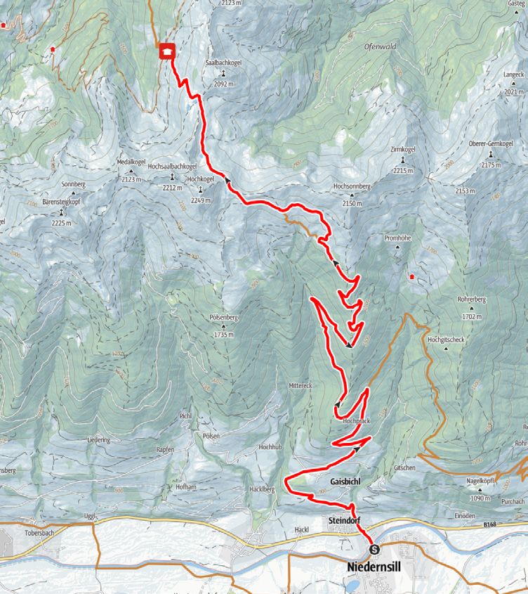
13C I Bad Fusch - Embach Hochalm mittel I medium
Start: Fusch
Ziel | destination: Embach Hochalm
In die Bad Fuscher Straße einbiegen und Turn into Bad Fuscher street and
bergwärts bis Bad Fusch. Dem Forstweg cycle up to Bad Fusch. Follow the forest
durch ein Gatter folgen, nach der Links- road through the gate, after the left bend
kurve nach ca. 500 m rechts abzwei- turn right after about 500 m. Countinue
gen. Weiter bis zur Embach Hochalm. upwards to the Embach Hochalm.
13D I Trauneralm mittel I medium
Start: Mautstelle Ferleiten
Ziel | destination: Trauneralm
Von der Mautstelle Ferleiten am Tau- From the Ferleiten toll station, pass the
ernhaus vorbei und dem leicht anstei- Tauernhaus and follow the slightly ascen-
genden Forstweg ins Käfertal folgen. ding forest road into the Käfertal. After
Nach ca. 4 km links abzweigen, über about 4 km, turn left, cross the bridge and
die Brücke und am steiler ansteigen- follow the steeper road upwards to the
den Weg bergwärts bis zur Trauneralm. Trauneralm at 1,530 m above sea level.BRUCK FUSCH
12B I Kohlschnait mittel I medium
Start: Bruck
Ziel | destination: Bruck
Von der Ortsmitte dem Tauernradweg From the village centre follow the Tauern
Richtung Taxenbach bis Niederhof fol- Cycle Path in the direction of Taxenbach to
gen. Rechts abbiegen und bergwärts bis Niederhof. Turn right and continue uphill to
zum Berggasthof Kohlschnait (890 m). the Berggasthof Kohlschnait (890 m). From
Von dort ca. 500 m weiter hinauf und there, further uphill for about 500 m and
77
bei der Weggabelung rechts abbiegen. Ab turn right at the junction. From here cycle
hier talwärts und retour zum Startpunkt. downhill and back to the starting point.
12 D I Moosalm mittel I medium
Start: Bruck
Ziel | destination: Moosalm
Von Bruck entlang am Tauernradweg bis From Bruck along the Tauern Cycle Path to
Gries. Salzach, Eisenbahn und Bundes- Gries. Cross the Salzach river, railway and
straße überqueren. Bei der Bäckerei Ho- main road. Pass the Hohenwarter bakery,
henwarter vorbei, in den Grieser Graben continue into the Grieser Graben valley and
und der Beschilderung bis zur bewirt- follow the mountain bike signs upwards to
schafteten Moosalm auf 1.533 m folgen. the managed Moosalm at 1,533 m. Optio-
Von dort optional weiter zum Hundstein nal: further to the Hundstein summit (17A)
(17A) oder zur Abfahrt nach Bruck (12A). as well as to the way down to Bruck (12A).BIKEVERLEIH I BIKE RENTAL Kaprun Zell am See Bründl Sports Adventure Service Outdoorsports Rent Center Maiskogel Salzachtal Bundesstraße 22 Kitzsteinhornplatz 1b 5700 Zell am See 5710 Kaprun Tel. +43 6542 73525 Tel. +43 6547 8388 870 adventure@salzburg.co.at maiskogeltal@bruendl.at adventureservice.at bruendl.at Zell am See Zell am See Sport 2000 - Carve In Sport Achleitner Postplatz 4 Postplatz 2 5700 Zell am See 5700 Zell am See Tel. +43 6542 5507 32 Tel. +43 6542 73581 info@ski-mobil.at office@sport-achleitner.at ski-mobil.at sport-achleitner.at Zell am See Zell am See Fahrrad-Center Intersport Scholz Kitzsteinhornstraße 1 Bahnhofstraße 13 5700 Zell am See 5700 Zell am See Tel. +43 6542 53151 Tel. +43 6542 72606 fahrrad-center@aon.at office@intersport-scholz.at fahrrad-center.at intersport-scholz.at Mittersill Intersport Breitfuss Grubing 50 5731 Hollersbach Tel. +43 6562 70081 talstation@sport-breitfuss.com sport-breitfuss.com
E-BIKE LADESTATIONEN I                             E-BIKE CHARGING STATIONS

Piesendorf-Niedernsill
Jausenstaion Dietlgut I Hummersdorferstraße 18, Tel. +43 664 1751 758
Pinzgauer Hütte I Schmittenhöhe, Tel. +43 6549 7861

Zell am See-Kaprun
Zell am See I Schlossplatz
Zell am See I Seegasse, Tel. +43 6245 74150
Zell am See I Strandbad Thumersbach I Pocherweg 28, Tel. +43 6542 7850
Zell am See I Strandbad Seespitz I Seespitzstraße 3, Tel. +43 6542 55152
Zell am See I Flugplatzstraße 24
Kaprun I Alpincenter Kitzsteinhorn, Tel. +43 6547 8621

                                                                                          79
Saalbach-Hinterglemm
Hacklbergalm I Schwarzachergraben 53, Tel. +43 676 8442 4660
Bründl Sports I Oberdorf 189, Tel. +43 6541 20220

BIKE SERVICESTATIONEN I                                 BIKE SERVICE STATIONS

Piesendorf                    Uttendorf                     Zell am See
Michi‘s Radlschrauberei       Sport Günther                 Intersport Scholz
Gewerbegebiet 539             Stubachstraße 16a             Bahnhofstraße 13
5721 Piesendorf               5723 Uttendorf                5700 Zell am See
Tel. +43 6549 20427           Tel. +43 6563 8045            Tel. +43 6542 72606
michi@radlschrauberei.at      p.guenther@sport2000.at       office@intersport-scholz.at
radlschrauberei.at            sport2000-guenther.at         intersport-scholz.at

Zell am See                   Kaprun
Fahrrad-Center                Bründl Sports Waidmannsheil
Kitzsteinhornstraße 1         Nikolaus-Gassner-Straße 1
5700 Zell am See              5710 Kaprun
Tel. +43 6542 53151           Tel. +43 6547 8388 60
fahrrad-center@aon.at         waidmannsheil@bruendl.at
fahrrad-center.at             bruendl.at
HÜTTEN & JAUSENSTATIONEN
Hochsonnbergalm Pinzgauer Hütte Schaunbergalm
1.841 m 1.704 m 1.519 m
5721 Piesendorf Nr. 145, 5721 Piesendorf Mühlbachtal
Tel. +43 664 2819 053 Tel. +43 6549 7861 5722 Niedernsill
Tel. +43 664 5455 568 info@pinzgauer-huette.at Tel. +43 6549 7362
pinzgauer-huette.at Tel. +43 6547 7604 (Alm)
Unterbergalm Jausenstation Burgeck Einödhof
1.570 m 919 m 769 m
5721 Piesendorf Schattbergstraße 26 Hummersdorf 26
Tel. +43 664 4427 666 5722 Niedernsill 5721 Piesendorf
m.unterbergalm@aon.at Tel. +43 6548 8340 Tel. +43 6549 7750
info@burgeck.at einoedhof@aon.at
burgeck.at einoedhof-piesendorf.at
Jausenstation Dietlgut Naglbauer Salzburger Hütte
769 m 1.046 m 1.879 m
Hummersdorferstraße 18 5721 Piesendorf, Rohrerberg 36 5710 Kaprun, Kitzsteinhorn
5721 Piesendorf Tel. +43 6549 7557 Tel. +43 6549 7349
Tel. +43 664 1751 758 urlaub@naglbauer.at info@klawunn.at
b.kapeller@gmx.at naglbauer.at salzburger-huette.at
Maiskogel Alm Ranch Glocknerblick Saulochalm
1.545 m 1.659 m 1.570 m
Maiskogelweg 25 Maiskogelweg 35 Maiskogelweg 30
5710 Kaprun 5710 Kaprun 5710 Kaprun
Tel. +43 676 5275 740 Tel. +43 664 8206 000 Tel. +43 699 1721 9108
info@maiskogelalm.at glocknerblick@sbg.at
maiskogelalm.at glocknerblick-kaprun.atSie können auch lesen