Schoettle-Areal Urban Transformation: Integrated Research and Design II - ILPOE, Uni Stuttgart
←
→
Transkription von Seiteninhalten
Wenn Ihr Browser die Seite nicht korrekt rendert, bitte, lesen Sie den Inhalt der Seite unten
Integrated Research and Design II
Summer term 2022
                                    Urban Transformation:
                                    Schoettle-Areal
Documentation / Dokumentation
Summer term 2022
Sommersemester 2022

Publishers / Herausgeber
Universität Stuttgart
M.Sc. Integrated Urbanism & Design (IUSD)
Institut für Landschaftsplanung und Ökologie (ILPÖ)

Institutes Directors / Institutsleiterinnen
Prof. Dr. Leonie Fischer (ILPÖ)
Prof. Dr. Astrid Ley (SI)

Academic Staff / Akademische Mitarbeiter*innen
M.Sc. Jesús Martínez Zárate (ILPÖ)
M.Sc. Friederike Thonke (SI)

Editorial and Design / Redaktion und Gestaltung
M.Sc. Jesús Martínez Zárate (ILPÖ)
M.Sc. Friederike Thonke (SI)
Jonas Czikl (ILPÖ)
Alfred Palacios (ILPÖ)

Guests / Gäste
Engelhardt, Anthea                           Projektkoordination KUGEL - Internationaler Bund e.V. (IB)
Strömer, Kalle                               Stadtplanungsamt Heidelberg - Abteilung Städtebau und Konversion
Runge, Anette                                Familienzentrum Stuttgart e.V. (MüZe Süd)
Bansbach, Barbara
Schulze, Dorothea                            Initiative Solidarische Nachbarschaft Schoettle-Areal
Britta, Wente
Schlegel, Sandra
Fadini, Thomas
Gantert, Marius                              TELEINTERNETCAFE Architektur und Urbanismus
Bauer, Markus                                Internationale Bauaustellung 2027 (IBA’27)
Srivastava, Rahul                            urbz
Echanove , Matias
Kramer, Wulf                                 Yalla Yalla! Studio for change
Bauer, Sascha                                Studio Cross Scale

Participants of the Panel Discussion / Teilnehmende an der Podiumsdiskussion
Pätzold, Peter                Bürgermeister der Landeshauptstadt Stuttgart. Referat Städtebau, Wohnen und Umwelt
Grieb, Raiko                  Bezirksvorsteher Bezirksbeirat Stuttgart Süd
Gerstenäcker, Christel        NaturFreunde in Heslach e.V.
Fadini, Thomas                Initiative Solidarische Nachbarschaft Schoettle-Areal
Hofer, Andreas                Intendant der IBA’27 GmbH

Image Sources / Bildquellen
Unless otherwise stated, photos and illustrations were taken by staff and students of
the institute / Soweit nicht anders angegeben stammen Fotos und Illustrationen von
Mitarbeiter*innen und Studierenden des Instituts

Stuttgart, February 2023
Acknowledgements

In the summer term of 2022, the M.Sc. programme            Im Sommersemester 2022 bearbeitete der M.Sc.
Integrated Urbanism & Sustainable Design (IUSD),           Studiengang Integrated Urbanism & Sustainable
jointly conducted by the Institute of Landscape            Design (IUSD), gemeinsam durchgeführt vom
Planning and Ecology (ILPÖ) and the Chair of               Institut für Landschaftsplanung und Ökologie (ILPÖ)
International Urbanism of the Institute of Urban           und dem Lehrstuhl Internationaler Städtebau am
Planning and Design (SI) at the University of Stuttgart,   Städtebau-Institut (SI) der Universität Stuttgart
worked on an integrated design project about urban         ein integriertes Entwurfsprojekt über urbane
transformation processes in Heslach, a district in the     Transformationsprozesse in Heslach, ein Stadtteil in
south of Stuttgart. The building complex at Böblinger      Stuttgart-Süd. Der Gebäudekomplex Böblinger Straße
Straße 68, the location of the Statistical State Office    68, seit 1974 Sitz des Statistischen Landesamtes,
since 1974, and the complex currently used by the          und der derzeit von der Universität Stuttgart
University of Stuttgart at Böblinger Straße 70-78, were    genutzte Komplex in der Böblinger Straße 70-78,
used a case study. These two complexes are now             wurden als Fallstudie verwendet. Diese beiden
commonly referred to as the ”Schoettle-Areal”.             Gebäudekomplexe werden heute gemeinsam als
                                                           „Schoettle-Areal“ bezeichnet.
With the objective of developing strategies and
solutions using co-creative design methods, the            Mit dem Ziel, Strategien und Lösungen durch co-
project asked: How can a new Schoettle-Areal drive         kreative Gestaltungsmethoden zu entwickeln, stellte
the transformation towards a socially just, culturally     das Projekt die Frage: Wie kann ein neues Schoettle-
diverse, and productive, yet ecologically responsible,     Areal die Transformation hin zu einem sozial
Stuttgart-Süd?                                             gerechten, kulturell vielfältigen und produktiven,
                                                           aber ökologisch verantwortungsvollen Stuttgart-Süd
To integrate the needs and demands of the                  vorantreiben?
neighbours and local actors, the project relied
on local initiatives and partners like the Initiative      Um die Bedürfnisse und Forderungen der
“Solidarische Nachbarschaft – Schoettle-Areal” that        Nachbar*innen und lokalen Akteur*innen zu
opened communication channels for the project,             integrieren, stützte sich das Projekt auf lokale
allowing staff and students to have insightful             Initiativen und Partner*innen wie die Initiative
exchanges that helped bridge the current local needs       „Solidarische Nachbarschaft – Schoettle-Areal“. So
with the long-term development objectives of a             gelang es, die Kommunikationskanäle für das Projekt
sustainable city.                                          zu öffnen, und Mitarbeiter*innen und Studierende
                                                           einen aufschlussreichen Austausch ermöglichte
The IUSD programme thanks all the organizations,           die dazu beigetragen haben, die aktuellen lokalen
institutions, local partners, and neighbours that          Bedürfnisse mit den langfristigen Entwicklungszielen
contributed their ideas, time, resources, and              einer nachhaltigen Stadt zu verbinden.
knowledge. We hope the visions and strategies
developed in this studio can help you lead a resilient     Das IUSD Programm dankt allen Organisationen,
urban transformation.                                      Institutionen, lokalen Partner*innen und
                                                           Nachbar*innen, die ihre Ideen, Zeit, Ressourcen und
                                                           ihr Wissen beigesteuert haben. Wir hoffen, dass die in
                                                           diesem Studio entwickelten Visionen und Strategien
                                                           ihnen helfen können, eine nachhaltige urbane
                                                           Transformation zu leiten.

                     Urban Transformation: Schoettle-Areal Summer term 2022                                  1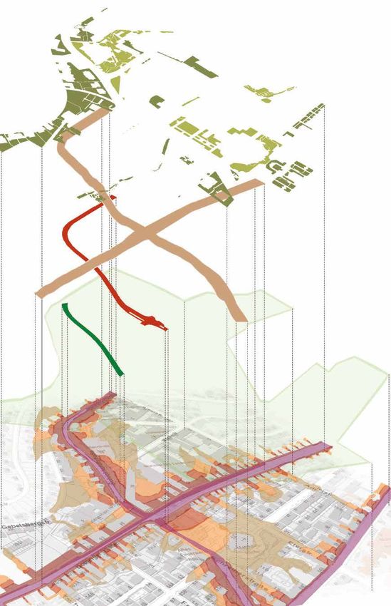
2 M.Sc. Integrated Urbanism & Sustainable Design (IUSD)
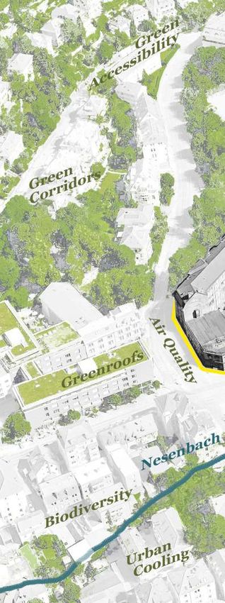
Table of Contents

      Introduction                                                              5

      Phase I. Site Analysis                                                    7

          Blue and Green Infrastructure                                         9
               Historical Development
               Mapping Blue and Green Infrastructure in Heslach
               Blue and Green Infrastructure in the Schoettle-Areal
               Users’ Perspectives
               Stakeholder Analysis
               Conclusion and Prospects

          Social, Cultural, and Economic Infrastructure                     17
               The Four Plazas
               Social, Cultural, and Economic Networks
               Evaluation of Spatial Usage
               Conclusion and Prospects

          Housing and Built Environment                                     25
               General Built Environment Context
               Building Typology and Function
               Housing
               Users’ Perspectives
               Conclusion and Prospects

      Phase II. Strategic Planning and Spatial Interactions                 31

          Connecting through Greenery                                       33

          Zuhause                                                           41

          Local Economies                                                   51

          Seedling for Social Interactions                                  59

          Wasser für Alle                                                   67

      Impressions from the Studio                                           79

                   Urban Transformation: Schoettle-Areal Summer term 2022   3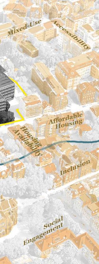
Phase I.                                 Phase II.
    Site Analysis                            Strategic Planning                      Spatial Interactions
    Standort Analyse                         Strategische Planung                    Räumliche Interaktionen
    • Blue and green infrastructure          • Creating a socially just vision       • Co-design and production of
      Blaue und grüne Infrastruktur            together                                pop-up installations
    • Housing and built environment            Entwicklung einer gemeinsamen           Co-Design und Umsetzung von
      Wohnen und gebaute Umwelt                sozialgerechten Vision                  Pop-Up Installationen
    • Social, cultural, and economic         • Strategic development of individual
      infrastructure                           topics
      Soziale, kulturelle und                  Strategische Entwicklung einzelner
      ökonomische Infrastruktur                Themenbereiche

4                       M.Sc. Integrated Urbanism & Sustainable Design (IUSD)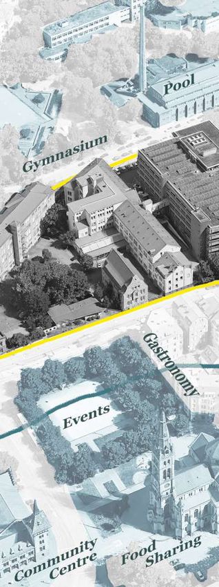
Introduction

The project “Urban Transformation: Schoettle-Areal”               Das Projekt „Urban Transformation: Schoettle-
addresses two major challenges of urban development. First,       Areal“ adressiert zwei große Herausforderungen der
the integration of green and blue spaces in cityscapes to         Stadtentwicklung: Erstens, die Integration von grünen
foster climate-resilient cities and societies. Second, the need   und blauen Strukturen in urbanen Landschaften, um
for flexible and affordable housing models due to increasing      klimaresiliente Städte und Gesellschaften zu fördern,
urbanization.                                                     zweitens, den Bedarf an flexiblen und bezahlbaren
                                                                  Wohnmodellen aufgrund der zunehmenden Urbanisierung
The pressure to act requires innovative and integrated            zu diskutieren.
approaches that comprise cultural, social, and economic
perspectives that also consider potential conflicts,              Der Handlungsdruck erfordert innovative und integrierte
thereby facilitating tangible short- and long-term urban          Ansätze, die kulturelle, gesellschaftliche und ökonomische
transformation for citizens and the city administration. With     Perspektiven umfassen, und gleichzeitig Konfliktpotenziale
its 15,000 square meter footprint, the Schoettle-Areal in         zu berücksichtigen, um so kurz- und langfristige urbane
Stuttgart-Süd offers an ideal opportunity to accommodate          Transformation für Bürger*innen und Stadtverwaltung zu
solutions for different needs, actors, and timeframes.            ermöglichen. Das Schoettle-Areal in Stuttgart-Süd bietet
                                                                  mit seinen 15.000 Quadratmetern eine ideale Möglichkeit,
According to the latest public statements, the Schoettle-Areal    Lösungen für unterschiedliche Bedürfnisse, Akteur*innen und
is planned to become vacant in phases, adding another layer       Zeiträume hervorzubringen.
of complexity to the planning: the statistical office plans to
move out at the end of 2023 while the university estimates        Das Schoettle-Areal soll nach jüngsten öffentlichen
2035 as a likely target for relocation of their laboratory and    Bekanntmachungen phasenweise frei werden, was die
offices.                                                          Planung noch komplexer macht: das Statistische Landesamt
                                                                  plant den Auszug Ende 2023, die Universität rechnet mit einer
The design studio first focused on analysing the local context    Verlegung der Labor- und Büroräume im Jahr 2035.
under ecological, cultural, economic, social, and planning
lenses (Phase I). The acquired knowledge was then used            Das Entwurfsstudio konzentrierte sich zunächst auf
to extract five topics of concern for the locals, for which       die Analyse des lokalen Kontexts unter ökologischen,
transformation processes were designed that tackled these         kulturellen, ökonomischen, sozialen und planerischen
issues while also addressing the challenges of sustainable        Gesichtspunkten (Phase I). Aus den gewonnenen
urban development (Phase II).                                     Erkenntnissen wurden anschließend fünf Themenfelder
                                                                  herausgearbeitet, die die Menschen vor Ort bewegen, und
This documentation summarizes the studio’s work in its            für die Transformationsprozesse konzipiert wurden, die diese
original version (English) and supplements it with individual     Themen angehen und gleichzeitig die Herausforderungen
introductions and summaries in German and English.                einer nachhaltigen Stadtentwicklung adressieren (Phase II).

                                                                  Diese Dokumentation fasst die Arbeiten des Studios in ihren
                                                                  Originalversionen zusammen (englisch) und ergänzt sie
                                                                  mit einzelnen Einleitungen und Zusammenfassungen auf
                                                                  deutsch und englisch.

                                             Urban Transformation: Schoettle-Areal Summer term 2022                        5
Phase I. Site Analysis

  6                      M.Sc. Integrated Urbanism & Sustainable Design (IUSD)
Phase I. Site Analysis

       The first phase focused on understanding the       In der ersten Phase ging es um das Verstehen
       surroundings of the Schoettle-Areal and the        der Umgebung des Schoettle-Areals und des
       neighbourhood of Heslach. Heslach’s social         Stadtteils Heslach. Untersucht wurde die
       and cultural relevance for Stuttgart-Süd was       soziale und kulturelle Relevanz Heslachs für
       examined, as well as how its location between      Stuttgart-Süd, und wie deren Lage zwischen
       the Hasenberg and the Nesenbachtal influences      dem Hasenberg und dem Nesenbachtal die
       the built environment, and how water and           bauliche Umwelt beeinflusst, und wie Wasser
       vegetation (green and blue infrastructure) are     und Vegetation (grüne und blaue Infrastruktur)
       integrated in the daily life of the community.     Bestandteil im Leben der Nachbarschaft ist.

       To analyse these aspects together with the local   Um diese Aspekte zusammen mit der lokalen
       community and to integrate their knowledge         Gemeinschaft zu analysieren und ihr Wissen
       with the findings of the design studio, various    in den Erkenntnissen des Entwurfsstudios zu
       methods and tools for spatial, social, and         integrieren, wurden verschiedene Methoden
       governance research were implemented. This         und Werkzeuge der räumlichen, sozialen und
       chapter documents these results.                   administrativen Forschung angewendet. Dieses
                                                          Kapitel dokumentiert diese Ergebnisse.

                         Urban Transformation: Schoettle-Areal Summer term 2022                       7
Phase I. Site Analysis
Green spaces
Private green
Public green
Traffic emissions
Very high traffic load
Particulate matter
Particulate matter ≥22
Nitrogen dioxide
≥36 µm/m3
≥32 µm/m3
The european limit value for the
concentration is 40 µm/m3
Noise levels dB(A)
≥50-55
≥55-60
≥60-65
≥65-70
≥70-75
Fig. 1 - Meso-scale:
Traffic, Pollution and Noise Map
based on Landeshauptstadt Stuttgart 2017
8 M.Sc. Integrated Urbanism & Sustainable Design (IUSD)Blue and Green Infrastructure
A. Shrivastava, G.A. Rivera Echavarría, M.J. Palacio Ramirez,
V. Krimmer, A. Altom Babiker Mohammed, V. Kumar and D. Loli Teza
Urban blue and green infrastructure (BGI) Urbane blaue und grüne Infrastruktur (BGI)
refers to the renaturation, integration, and bezieht sich auf die Renaturierung, Integration
implementation of waterbodies and vegetation und Implementierung von Gewässern und
in urban areas. Urban BGI is recognized as a Vegetation im urbanen Raum. Urban BGI
method to help mitigate the effects of climate ist eine Methode, um die Auswirkungen
change and the urban heat island (UHI) effect, des Klimawandels und des urbane
as well as support personal well-being. Wärmeinseleffekts (UHI) abzumildern und das
Wohlbefinden der Menschen zu fördern.
While settlement density has increased in
recent decades, the number of waterbodies Während die Siedlungsdichte in den letzten
in Stuttgart Süd has decreased by 2.7% in the Jahrzehnten zugenommen hat, ist die Anzahl
last 10 years. Currently, only 0.2% of the district der Gewässer in Stuttgart-Süd in den letzten
footprint are waterbodies. The area of open 10 Jahren um 2,7 % zurückgegangen. Derzeit
space per inhabitant has also decreased by 5.2% beträgt die Gewässerfläche nur noch 0,2 %
(Landeshauptstadt Stuttgart 2020). des gesamten Stadtteils. Auch die Freifläche
pro Einwohner*in hat sich um 5,2 % reduziert
This analysis focuses on the mapping of (Landeshauptstadt Stuttgart 2020).
waterbodies and vegetation as well as their
perception by local users in the vicinity of the Im Mittelpunkt der Analyse steht die Kartierung
Schoettle-Areal. von Gewässern und Vegetation sowie deren
Wahrnehmung durch lokale Nutzer*innen im
Umfeld des Schoettle-Areals.
Urban Transformation: Schoettle-Areal Summer term 2022 9Phase I. Site Analysis
*UHHQDQG%OXH 7HPSRUDOPDSSLQJ
LQIUDVWUXFWXUH
Historical Development
Up until 1895 the majority of development in Stuttgart Süd was
concentrated in the valley area, the Nesenbachtal-- the current location of
8QGHUVWDQGLQJH[LVWLQJEOXHDQGJUHHQ $OWRPB.XPDUB7H]D
Böblinger- and Möhringer Straße. The south slope of the Hasenberg was
LQIUDVWUXFWXUHVWDNHKROGHULQYROYHGDQGXVHU¶V
used mostly for viticulture purposes, which was the main source of income
SHUFHSWLRQZLWKIRFXVLQWKH6KRHWWOH$UHDO
for the Heslachers until the turn of the century.
Methods used: temporal mapping, diȥerent mappings scales,
Bytypology mapping,
1950, housing ecosystem analysis,
development stakeholderhills
in the Hasenberg analysis,
saw a visible
semi-structured
increase of housesinterviews
and newand SWOT
streets, analysis. the privatization of green
increasing
spaces and street trees as private gardens. Furthermore, the Nesenbach, a
XH 7HPSRUDOPDSSLQJ
Neckar-tributary, was covered and converted into a storm drainage (Fig. 2).
0DFUROHYHO
Fortunately, endangered Stuttgat 1895
stone crayfish were able to survive at the inlets.
Source: Stadtarchiv Stuttgart
Stuttgat 1950
Source: Stadtarchi
In 1997, the city council passed the climate protection plan, ‘City nestled
between forest and vineyard’ in order to preserve its green infrastructure
on hills, slopes, and in the valley. Key green and blue infrastructure around
the Schoettle-Areal include urban parks like Hasenberg and Karlshöhe,
¶V public squares like Erwin-Schoettle-Platz, Bihlplatz, and Marienplatz,
the Heslacher-, Dornhalden- and Fangelsbachfriedhof, and several
playgrounds along the remains of the Nesenbach.
les,
sis,
The topography clearly defines the nature of green cover: The slopes
north of the Schoettle Areal have a greater green cover and an occasional
forested area, whereas the majority of surfaces in the lower valley areas are
sealed, and green areas are smaller and dispersed.
Stuttgat 1895 Stuttgat 1950
Source: Stadtarchiv Stuttgart Source: Stadtarchiv Stuttgart
Fig. 2 - Heslach in 1895 (top)
Mapping Blue and Green and 1950 (bottom).
Stadtarchiv Stuttgart
Infrastructure in Heslach
The size, typology, and interconnection of green elements, as well as their
relation to the surrounding built environment impact the environmental
quality of urban spaces. Interconnected green infrastructure typologies • The most common typologies are
have a higher potential of mitigating climate-related stressors like the private gardens of different sizes and
urban heat island effect (UHI) and water management challenges, for single-line street trees with a small
example by facilitating cool air corridors and supporting increased water vegetation bed.
percolation (Sponge city principle).
Green belt Strategy
Source: Department of City Planning and Housing of Stuttgart
Stuttgart 2021
Source: Google Maps • Slopes have a higher density of these
0HVROHYHO typologies as compared to the valley
Twelve types of blue-green infrastructure were identified in reference to areas.
the “UNaLab Nature-based Solutions Technical Handbook Factsheets” • Some streets do not have any green
(Eisenberg et al.
A total of 12 2022).blue-green
diȥerent Elements infrastructure
within these typologies such as noise
typologies were infrastructure typology. The predom-
barriers, seating,
identified and playgrounds
in reference also servefortoNature
to UNaLab handbook enhance the social quality
based inance of sealed surfaces reduces
in solutions
the area (Fig. 3). areas. Followings are some key observations:
for urban the quality of stay in the area and
discourages social interactions.
- The most common
A correlation betweentypologies are private
higher levels gardens
of pollution of diȥerent
(noise, air quality, and
sizes and single line street strees with a small vegetation bed;became clear. • While most of the typologies are
traffic) and areas with a high percentage of sealed surfaces located in public areas, the typology
- Slopes have higher density of these typologies as compared to
This observation was later confirmed by the input of users, who expressed of private gardens, which is the most
valley areas;
a desire
- Somefor moredousable
streets green
not have anyspaces in the valley typology;
green infrastructure areas and around the common typology and contains the
Schoettle-Areal. highest number of trees, remains
Stuttgart 2021 inaccessible to the general
Maps arepublic.
not to scale and horth is up
The green
Source: and blue elements scattered through the built environment
Google Maps
• Two water fountains were identified as
affect the accessibility of these spaces for local animals (Fig. 4). In a the only elements of blue infrastructure
neighbourhood like Heslach, the fragmented green spaces remain in the area, though they were not in
accessible for longer-range flying animals, while ground-based and short- operation at the time of observation.
were range fauna are limited to exist in small niches due to the human-made
sed barriers.
ations: T Single line trees with vegetation
Source: Danielli Loli Teza
T Single line trees without vegetation
Source: Danielli Loli Teza
erent
ed;
red to 10 M.Sc. Integrated Urbanism & Sustainable Design (IUSD)
gy;Blue and Green Infrastructure
Stuttgart 2021 Maps are not to scale an
f Stuttgart Source: Google Maps
Fig. 3 - Green and blue infrastructure
een infrastructure typologies were typologies.
Lab handbook for Nature based Authors’ work
lowings are some key observations:
Green corridor
es are private gardensGreen
of diȥerent
roof (intensive/extensive)
ees with a small vegetation bed;vegetation bed
Permeable
of these typologies asVertical
compared to
greening
Noise barrier
ny green infrastructureSlope protection
typology;
Boulevard
Group of trees
Private garden
Single-line trees with vegetation
Single-line trees without vegetation
Single street trees
T Single line trees without vegetation
Source: Danielli Loli Teza
B Boulevard
Source: Google street view
Private garden Typologies
Source: Aya Altom Source: Group work
Fig. 4 - Mesoelements of blue green
infrastructure and fauna accessibility.
Authors’ work
R Green roof Permable vegetation bed V Vertical greening Noise barrier S Slope protection
Source: Danielli Loli Teza Source: Danielli Loli Teza Source: Danielli Loli Teza Source: Danielli Loli Teza Source: Danielli Loli Teza
Urban Transformation: Schoettle-Areal Summer term 2022 11Phase I. Site Analysis
Blue and Green Infrastructure
in the Schoettle-Areal
The Schoettle Areal is located at the junction of two busy streets that
create a physical barrier between the nearby blocks on the south-west
with the Areal: The Schickard-/Schreiberstraße with heavy car traffic and
the Böblingerstraße with an U-Bahn station running several lines every
couple of minutes. To the north-east the connecting streets Mörike- and
Adlerstraße are quieter, serving mostly local traffic.
The Schoettle-Areal itself has a number of green typologies including:
single-line trees, vegetation beds, and groups of trees (arboretums) in the
parking area behind the university building in the Mörikestraße in close
proximity to several group of trees near the Schickhardt-Sporthalle (Fig. 5).
The buildings inside the areal physically divide the space, making it harder
for fauna to move between the different areas of the complex.
An inventory of the flora on site showed approximately 30 species, some Single line trees with vegetation
are widespread in Heslach, such as the Norway maple tree (Ahorn) and Single line trees without vegetation
Group of trees
English ivy (Efeu), and other less common species like the Horse chestnut
Private garden
(Rosskastanien) and Common snowberry (Schneebeeren). Green corridor
Green cover makes up only 7% of the areal with a predominance of sealed Fig. 5 - Green infrastructure in the
surfaces. An “i- Tree Canopy” analysis to the street block (Fig. 6) shows this Schoettle-Areal.
disparity between built elements (impervious roads and buildings) and Authors’ work
the green elements (grass, trees, and shrubs).
Current Land Cover
40%
3ac
Area Covered (ac)
30%
2ac
% Covered
20%
1ac
10%
0% 0ac
Fig. 6 - i-Tree canopy analysis of the
Grass/ Impervious Impervious Impervious Soil/ Tree/ Water current state of the Schoettle-Areal.
Herbaceous Building Other Road Bare Ground Shrub Authors’ work
12 M.Sc. Integrated Urbanism & Sustainable Design (IUSD)Blue and Green Infrastructure
Green space rating Users’ Perspectives
Surveys and interviews with residents, visitors, and employees in the area
Blue infrastructure helped understand their perception of green and blue elements, their
environmental needs, and where they see areas for improvement: Only
Awareness Use of Unaware of 10% of the interviewees rated the quantity of green spaces in the close
rainwater rainwater use surroundings as good. A common consensus was the need for more green
spaces for socializing, driven more by personal needs and immediate
improvement in quality of life than any concrete ecological background.
Users felt a lack of:
Furthermore, it was evident that the interviewees feel somewhat
disconnected from the scattered greenery in the immediate area. Even
Playgrounds Benches Lawns
(leisure) though both Hasenberg to the north and Weinsteige to the south are far
away for an everyday visit and difficult to access for people with reduced
mobility, the interviewees felt visually connected to the forested slopes.
Despite the common desire for more communal green spaces, a few users
fear the loss of parking space and prioritize the individual need for more
Green streets Grades Safe parks Water
of shading (visibility) features parking slots, seeing the status-quo as a necessary compromise.
Stakeholder Analysis
The owner of both plots comprising the Schoettle-Areal is the State of
Baden-Württemberg, making it a key decision maker holding political and
administrative power. The district (Bezirksbeirat) and city (Gemeinderat)
political levels are interested in the future development of the area
also making them relevant supporters or delayers. The latest official
statements (July 2022) presume an interest from the City of Stuttgart to
acquire the plot of the Statistical Office from the State.
On an administrative level, the Office for Housing and Planning – planning
division Süd (Amt für Stadplanung und Wohnen – ‘Planungsbezirke Süd)
holds the responsibility to plan new green areas. They are therefore
a relevant partner for implementation. Regarding maintenance, the
responsible parties are the Garden, Cemetery and Forestry Office (Garten-
Friedhofs- und Forstamt) at the city level, and the Wilhelma Zoo at the
state level.
The presence of some non-governmental initiatives at the neighbourhood
level like the ‘Naturfreunde Heslach’ imply an interest in the community
about public green spaces. Still, more public attention needs to be drawn
towards the value of BGI and a greener neighbourhood. The momentum
generated by the initiative ‘Solidarische Nachbarschaft Schoettle-Areal’
towards housing, can potentially introduce green initiatives driven by the
community to improve the green qualities of the area.
Close relationship
Organized cooperation
Direction of dominance
Posible clash
Unclear relationship
Fig. 7 - Analysis of relevant stakeholders and
their relationship to one another.
Authors’ work
Urban Transformation: Schoettle-Areal Summer term 2022 13Phase I. Site Analysis
Conclusion and Prospects
The green and blue spaces in and around the Die grünen und blauen Infrastrukturen im und
Schoettle-Areal are scarce and are likely to um das Schoettle-Areal sind knapp, und werden
decline even further. While the proximity to voraussichtlich noch weiter zurückgehen. Und
the green slopes of Hasenberg and Degerloch obwohl die Nähe zu den grünen Hanglagen
contribute to a visual connection with greenery, von Hasenberg und Degerloch zu einer
the analysis shows a scattered and minimal visuellen Verbindung mit Grün beiträgt, zeigt
green footprint in the close surroundings. We die Analyse nur eine verstreute und minimale
found the need to increase the amount of green grüne Umgebung. Wir haben deshalb die
elements and improve their connectivity to Notwendigkeit, die Menge an grünen Elementen
improve the resilience of Heslach. zu erhöhen und ihre Konnektivität zu verbessern,
um die Widerstandsfähigkeit von Heslach zu
The hilly topography represents a great asset for verbessern, im Entwurfsstudio definiert.
the macro-climate of Stuttgart, creating cool-
air corridors and supporting flora and fauna. Die hügelige Topografie stellt eine große
However, at a local scale the topography acts Bereicherung für das Stuttgarter Stadtklima
as a social divider, inhibiting the accessibility of dar; es schafft Kaltluftkorridore und unterstützt
these natural areas that are primarily available Flora und Fauna. Auf lokaler Ebene wirkt die
to a minority people living on the slopes of the Topografie jedoch als soziale Trennlinie und
Hasenberg (“Halbhöhenlage”). This leaves the behindert die Zugänglichkeit dieser Naturräume,
majority of the neighbourhood to deal with die hauptsächlich einer an den Hängen des
the impacts of the urban heat island (UHI) Hasenbergs lebenden Minderheit zur direkten
effect (Fig. 8), which is exacerbated by the Verfügung stehen („Halbhöhenlage“). Damit
large proportion of sealed areas and the lack wird der Großteil des Quartiers mit den
of vegetation in the Nesenbachtal – today the Auswirkungen des urbanen Wärmeinseleffekts
Böblinger- and the Möhringer Straße. (UHI) konfrontiert, der durch den hohen Anteil an
versiegelten Flächen und die fehlende Vegetation
The Schoettle-Areal is not significantly greener im Nesenbachtal – der heutigen Böblinger- und
than its immediate surroundings. However, its Möhringer Straße – noch verstärkt wird.
proximity to other green areas and its size make
it a relevant starting point for the development Das Schoettle-Areal ist nicht wesentlich grüner
of a connected green infrastructure network. als seine unmittelbare Umgebung. Seine Nähe zu
The stakeholder analysis helped reveal the anderen Grünflächen und seine Größe machen
various actors that should be included in the es jedoch zu einem relevanten Ausgangspunkt
expansion of this green network, with a special für die Entwicklung eines zusammenhängender
focus on local voices. grüner Infrastrukturen Netzwerks. Die
Stakeholder-Analyse trug dazu bei, die
verschiedenen Akteur*innen aufzuzeigen, die in
den Ausbau dieses grünen Netzwerks einbezogen
werden sollten. Ein besonderer Fokus wurde auf
lokale Beteiligte gelegt.
References
Bundesministerium für Verkehr und digitale Infrastruktur (2011): Masterplan zur Gestaltung nachhaltiger und emis-
sionsfreier Mobilität. Green City Plan. Landeshauptstadt Stuttgart.
Landeshauptstadt Stuttgart (2020): Datenkompass Stadtbezirke Stuttgart - Ausgabe 2019/2020. Landeshauptstadt
Stuttgart.
Dreiseitl, H.; Wanschura, B. (2016): Strengthening Blue-Green Infrastructure in Our Cities - Enhancing Blue-Green
Infrastructure & Social Performance in High Density Urban Environments. Ramboll.
Eisenberg, B.; Chiesa, C.; Fischer, L.K.; Jakstis, K.; Polcher, V.; Schwarz-v. Raumer, H.G. (2022): Nature-based Solutions
Technical Handbook Factsheets. UNaLab Urban Nature Labs. Institut für Landschaftsplanung und Ökologie,
Universität Stuttgart. Stuttgart, 2022.
Weis, M.; Siedentop, S.; Minnich, L. (2011): Vulnerabilitätsbericht der Region Stuttgart. Verband Region Stuttgart, Insti-
tut für Raumordnung und Entwicklungsplanung Universität Stuttgart
14 M.Sc. Integrated Urbanism & Sustainable Design (IUSD)Blue and Green Infrastructure
Fig. 8 - Topographic section through the
Schoettle-Areal illustrating the ecological
contributions of blue and green
infrastructure to environmental quality.
Authors’ work
Green Corridor
Street without Green
Cool Air Inflow
Cool Air Inflow
Urban Heat Island
Single-Line Street Trees
Noise Barrier
Nesenbach
Forest
Schoettle Parklet
Urban Transformation: Schoettle-Areal Summer term 2022 15Phase I. Site Analysis
Negative Storytelling
and Cold Zones
Positive Storytelling
and Hot Zones
Hot and Cold Zones
Social
Cultural
Economic
Fig. 1 - Meso-scale:
Comparison of social, cultural
and economic hot and cold zones.
Authors’ work
16 M.Sc. Integrated Urbanism & Sustainable Design (IUSD)Social, Cultural, and
Economic Infrastructure
A.C. Camacho Gutierrez, A.-K. Schneider, S. Maharjan
Á. Algaba Díaz, S. Rao, Y. Al-Tubor
Infrastructure such as roads and railways, health Infrastruktur wie Straßen und Eisenbahnen,
and safety facilities, and water and electricity Gesundheits- und Sicherheitseinrichtungen
supply facilitates daily needs and is necessary sowie Strukturen der Wasser- und
for development. This subchapter examines the Stromversorgung erfüllen den täglichen Bedarf
social, cultural, and economic foundations that und sind für die Entwicklung notwendig.
contribute to just and resilient development. Dieses Unterkapitel widmet sich den sozialen,
kulturellen und wirtschaftlichen Grundlagen, die
Economic infrastructure (e.g., shops and zu einer gerechten und belastbaren Entwicklung
businesses) promotes economic activities and beitragen.
provides various services. Social infrastructure
provides healthcare, education, and space Wirtschaftliche Infrastruktur (z. B. Geschäfte
for interactions amongst neighbours in a safe und Betriebe) fördert wirtschaftliche
environment. Cultural infrastructure contributes Aktivitäten und erbringt verschiedene
to a sense of belonging by reflecting the Dienstleistungen. Die soziale Infrastruktur bietet
interests and needs of the neighbourhood. The Gesundheitsversorgung, Bildung und Raum
resulting network of such infrastructures offers für Interaktionen unter Nachbar*innen in einer
activities that have both direct and indirect sicheren Umgebung. Kulturelle Infrastruktur
effects on the quality of life. trägt zu einem Zugehörigkeitsgefühl bei,
indem sie die Interessen und Bedürfnisse
In Heslach, an axis of four plazas are the main der Nachbarschaft widerspiegelt. Das daraus
hubs of observation, namely: Marienplatz, resultierende Netzwerk solcher Infrastrukturen
Erwin-Schoettle-Platz, Bihlplatz, and Südheimer bietet Aktivitäten, die sowohl direkte als auch
Platz. indirekte Auswirkungen auf die Lebensqualität
haben.
In Heslach bildet eine Achse aus vier Plätzen
die wichtigsten Beobachtungspunkte für
die Entwurfsumgebung: Marienplatz, Erwin-
Schoettle-Platz, Bihlplatz und Südheimer Platz.
Urban Transformation: Schoettle-Areal Summer term 2022 17Phase I. Site Analysis
The Four Plazas
Böblingerstraße is a flat axis that connects four public squares in Stuttgart-
Süd. Marienplatz is located closest to the city centre, Erwin-Schoettle
Platz, is directly adjacent to Schoettle-Areal, Bihlplatz mark the western
border of Heslach, and Südheimer Platz is already in the middle of the
next district Sudheim.
Marienplatz is a bustling space for meeting and leisure. Cafés, restaurants,
playgrounds, supermarkets, and a city-rail line connecting the valley with
the Weinsteige make it an attractive and well frequented meeting-point.
Erwin-Schoettle-Platz is relatively calm and commonly used as a transit
space. Mostly older people spend time in this area and only a few local
shops contribute to its local atmosphere. A recent wave of communal
activities like food-sharing events, boule games, and table-tennis is
bringing younger people to the neighbourhood.
After Erwin-Schoettle-Platz the sidewalks of the Böblingerstraße become
narrower and underused shops start appearing more often. Still, livelier
places like smaller shops, bakeries, restaurants, the district library, and
youth centre are dispersed along the sidewalk. Bihlplatz is a public square Fig. 2 - Strollology in Stuttgart Süd, done on the
with a few restaurants and a small playground next to a small open space. 19th of April, 2022, at 9:00 AM and the
Although activities are limited, it is a local meeting point. Südheimer Platz, 23rd of April, 2022, at 6:00 PM.
crowns the axis with a livelier and spacious square with fitness equipment, Authors’ work
shaded seating areas, and greenery. It is the greenest of the four squares
with large playgrounds and many children are visible in this space.
Grafitti Barrier
Brewery
Hiking route Pathway
Kids playing
Bihlplatz
Südheimer Platz
Before: Disco
Now: Restaurant Bookstore
Urban furniture
Outdoor Exercise
18 M.Sc. Integrated Urbanism & Sustainable Design (IUSD)Social, Cultural and Economic Infrastructure
Restaurants
Zacke
Aldi construction site
Eateries and
supermarket
Food sharing Cafe’s with seating
Outside
People hanging out in
Marienplatz
Schoettle
Areal
Marienplatz
Erwin-
Schoettle
Platz Parked Cars
Library
Playground
Playing Boccia Outdoor seating of Cafés
Urban Transformation: Schoettle-Areal Summer term 2022 19Phase I. Site Analysis Social, Cultural, and Economic Networks A mental map was created with the feedback from interviews and questionnaires that depicts hot spots for activities and important meeting points for the neighbours. The map shows the underlying fabric of social, cultural, and economic networks in the area including its obstacles. Some inner-neighbourhood networks were identified including the Mütterzentrum (MüZe) family centre and the Mehrgenerationenhaus, which sources ingredients for its café from local stores thus supporting and attracting nearby neighbourhood residents. On the other hand, far-reaching networks attract people from outside of the neighbourhood like the Forró House and the Serbian church, which bring specific communities together from farther distances and draws attention to the multi-cultural exchanges taking place in Heslach. A Social, Cultural and Economic (SCE) network in Heslach has formed under the name “NAdIiQ”, the -Nachbarschaftlicher Austausch der Institutionen im Quartier (Neighbourly Exchange of the Institutions in the Neighbourhood), which includes several social and cultural organizations such as the MüZe, the Generationenhaus, the youth centre (Jugendhaus Heslach), the community centre (Altes Feuerwehrhaus), and the local library (Stadtteilbibliothek-Heslach). NAdIiQ aims to recognize and condense the needs of the community and foster its development, responding in a coordinated fashion that includes regular meetings and exchanging information between different organizations and its own networks. 20 M.Sc. Integrated Urbanism & Sustainable Design (IUSD)
Social, Cultural and Economic Infrastructure

                              Fig. 3 - Mental mapping of Heslach based on the
                              results of a semi-structured questionnaire.
                              Authors’ work

Urban Transformation: Schoettle-Areal Summer term 2022                          21
Phase I. Site Analysis
Evaluation of Spatial Usage Stuttgart Mitte
Stuttgart Mitte - S C E
23, 625 Population
The topography of the area once again plays a crucial role. SCE activities 40 Culture & Education
are concentrated along the Böblinger- / Möhringer Straße-axis with few of 52 Sport & Game 591
40 Health
the identified networks actively extending into the surrounding hills. Also 72 Tourism
454
591
the availability of recreational spaces in Heslach is severely limited (Fig. 4); 136 Family/ Social affairs 311
compared to the city average of 21 m2 per resident, Heslach only provides 22 Nature 174
80 Security 1074
approximately 4 m2 (Statistisches Amt Stuttgart 2020). 295
VS.
Heslach
Thirdly, the SCE spaces of Heslach cater to a diverse group of users: Heslach - S C E
Marienplatz is mostly frequented by young adults and working people 11, 140 Population
mostly, Erwin-Schoettle Platz seems to be especially attractive to the 5 Culture & Education
8 Sport & Game
elderly (Fig. 5), while children are the prominent users in Südheimerplatz. 2228
1 Health (Marienhospital) 1393
This is reflected in the cultural diversity represented along the Böblinger- 30 Tourism 11140
30 Family/ Social affairs 371
/ Möhringerstraße-Axis and impregnated in the SCE networks through 4 Nature 371
meeting places: from cafeterias and restaurants for specific groups of 1 Security 2785
people to the Stadtteilbibliothek as cultural hub in Heslach that hosts 1591
a wide range of events from small Verein’s meetings to cultural and Fig. 4 - A comparison of SCE infrastructure of Heslach
neighbourhood festivals. and Stadtmitte and its availability.
Authors’ work
Fig. 5 - Spatial usage of the Erwin-Schoettle Platz
by age group and its distribution throughout the day.
Authors’ work
Weekday
Of the 29 responses to the
questionaire, five expressed a positive
experience regarding the safety and
calmness of the neighborhood in
terms of their general perceptions of
the atmosphere, while two expressed
a concern regarding secluded
alleyways and a need for more child-
friendly public spaces.
Weekend
Themes of community generally
relate to the perceived mix of user
groups or the social organizations
and their activities. Other prevalent
themes revolve around the subjective
needs regarding the local food and
recreational services in the area. For
instance, some concerns were raised
about the disappearance of small
privately-owned stores, either due to
rising rents or uncertain turnovers,
Elderly
since many shops became COVID-19
Adults test centers during the pandemic,
Teenagers resulting in empty store fronts and
Children vacancies.
Südheimer Platz Bihlplatz Erwin-Schoettle Platz Marienplatz
22 M.Sc. Integrated Urbanism & Sustainable Design (IUSD)Social, Cultural and Economic Infrastructure
Conclusion and Prospects
As a result of the narrow valley created Durch das topografisch bedingte, enge Tal
by the topography, the Böblinger- and bilden die Böblinger- und Möhringer Straße
Möhringer Straße act as the SCE-Axis for the die SCE-Achse für das Quartier. Diese Achse
neighbourhood. This axis physically connects verbindet räumlich die Innenstadt mit den
the city centre with the outer neighbourhood äußeren Stadtteilen Südheim und Kaltental
of Südheim and Kaltental through a chain of durch eine Kette von Plätzen, die wie Magnete
squares that act as magnets, attracting different wirken und mit ihren spezifischen Angeboten
users with its specific offers. Although this axis unterschiedliche Nutzer*innen anziehen.
helps connect different districts, it represents Obwohl diese Achse dazu beiträgt, verschiedene
a difficult-to-cross physical barrier for Heslach Stadtteile zu verbinden, stellt sie für die
residents, thereby reducing interaction between Einwohner*innen von Heslach eine schwer zu
both sides of the neighbourhood. überwindende physische Barriere dar, wodurch
die Interaktion zwischen beiden Talseiten des
Erwin-Schoettle-Platz, located across the street Stadtteils verringert wird.
from the Schoettle-Areal, is the link for Heslach
on the SCE-axis and therefore acts as a meeting Der Erwin-Schoettle-Platz, gegenüber dem
point for the neighbourhood. Although its Schoettle-Areal gelegen, ist das Bindeglied
services make it a mobility node and a transit- für Heslach auf der SCE-Achse und fungiert
dominated square, its nearby SCE offers, and somit als Treffpunkt für die Nachbarschaft.
open spaces make it a location for local social Obwohl es mit seinen Dienstleistungen
and cultural activities. ein Mobilitätsknotenpunkt und ein vom
Durchgangsverkehr dominierter Platz ist, ist
Nonetheless, the lack of public, open and es mit seinen nahe gelegenen SCE-Angeboten
above all consumerism-free spaces along und Freiflächen ein Ort für lokale soziale und
the SCE-axis and around the Schoettle-Areal kulturelle Aktivitäten.
puts extra pressure on new developments.
On the economic level, the few remaining Der Mangel an öffentlichen, offenen und vor
businesses face pressure in the form of allem konsumfreien Räumen entlang der SCE-
increasing rent prices, making them susceptible Achse und rund um das Schoettle-Areal erhöht
to displacement. An already multicultural jedoch den Druck auf neue Entwicklungen.
Heslach needs stronger partnerships and Aus wirtschaftlicher Sicht stehen die wenigen
support through programs of social and cultural verbliebenen Geschäfte vor steigenden
organizations that can provide legitimacy to Mietpreisen unter Druck, was sie anfällig für
the wider community and encourage active, Verdrängung macht. Ein bereits multikulturelles
affordable and collaborative development. Heslach braucht stärkere Partnerschaften und
Unterstützung durch Programme sozialer und
kultureller Organisationen, die der breiteren
Gemeinschaft Legitimität verleihen und
eine aktive, erschwingliche und kooperative
Entwicklung fördern können.
References
Jaworek, K. (2004): History - Heslach. Accessed in April 2022, at:
Landeshauptstadt Stuttgart (2020): Datenkompass Stadtbezirke Stuttgart - Ausgabe 2019/2020. Landeshauptstadt
Stuttgart.
Neth, S. (2018) Historical walk through Stuttgart-Heslach: The hiding place for the pregnant daughter. Accessed in
April 2022, at:
Wente, B. (2022): Solidarische Nachbarschaft Schoettle-Areal. Accessed in April 2022, at
Urban Transformation: Schoettle-Areal Summer term 2022 23Phase I. Site Analysis
Density Map
5+ storeys
3-4 storeys
1-2 storeys
Roof Typology Map
Gable roof
Flatroof
Crosshipped roof
Property Ownership Map
Rental properties
Owned properties
Rental Prices Map
+25 € per sqm.
19-25 € per sqm.
16-19 € per sqm.
Building Typology Map
Detached single housing units
Single multi-storey units
Housing blocks
Attached single housing units
Fig. 1 - Meso-scale:
Rental prices, property ownership,
typology and density map.
Authors’ work
24 M.Sc. Integrated Urbanism & Sustainable Design (IUSD)Housing and Built Environment
V. Ük, S. Rai, G. Machado Ferreira, V. Geiselbrechtinger,
M.P. Mejía Vanegas and L.A. Sánchez Muñoz
Adequate and affordable housing is one of the Angemessener und bezahlbarer Wohnraum ist
most important and basic human needs, and in eines der wichtigsten Grundbedürfnisse der
cities it largely impacts social interactions. Menschen und beeinflusst maßgeblich das
soziale Miteinander in Städten.
Historically, Heslach is a working-class district
with many workshops and industrial plants. As Historisch gesehen ist Heslach ein Arbeiterviertel
Stuttgart expanded in the last decades and its mit vielen Werkstätten und Industriebetrieben.
city centre became more attractive, a steady Als Stuttgart in den letzten Jahrzehnten
influx of people came into Heslach. This resulted expandierte und die Innenstadt attraktiver
in urban densification and an increase in prices wurde, kam ein stetiger Zuzug von Menschen
for residential and commercial real estate. nach Heslach. Dies führte zu einer Verdichtung
However, Heslach has experienced a population der Stadt und einem Anstieg der Preise für
decline in recent years, according to official city Wohn- und Gewerbeimmobilien. Allerdings hat
statistics (Social Monitoring LHS, 2020). Heslach laut amtlichen Statistiken (Statistisches
Amt Stuttgart 2020) in den letzten Jahren einen
These analyses include an examination of Bevölkerungsrückgang erlebt.
the residential density, rental prices, and the
typologies of buildings in connection with their Die Analysen beinhalten eine Untersuchung
geographical location. der Wohndichte, der Mietpreise und der
Gebäudetypologien in Verbindung mit ihrer
geografischen Lage.
Urban Transformation: Schoettle-Areal Summer term 2022 25Phase I. Site Analysis
General Built Environment Context
The topography of Stuttgart Süd is a defining factor for the built
environment. The first settlements in the area were established in the
valley and close to the Nesenbach. Industrial buildings were built here
starting in the early 1800s, which led to an increase of worker’s housing
that eventually reached the degree of density and the predominantly
closed block structure seen today. Due to the transition towards industrial
production, much of the surrounding hills previously used for viticulture
were gradually parcelled out and developed mainly from wealthier, private
buyers.
The accessibility of the area is also heavily impacted by the topography:
The flat areas of the valley are well connected due to the city railway
network (Stadtbahn), with stations located along the nodes of public
spaces such as the Marienplatz, Erwin-Schoettle Platz, Bihlplatz, and
Südheimer Platz. This contributes to relatively high pedestrian traffic,
despite car traffic remaining the dominant occupier of streetscapes. On Fig. 2 - Stairways connecting the various street
the other hand, the hills are limited to a secondary network of bus routes. levels along the slopes.
Walkways tend to be narrower, and the winding roads are only connected Authors’ image
by occasional stairways, making these areas inaccessible for the elderly or
people with limited mobility (Fig. 2).
Building Typology and Function
A variety of building typologies were identified in the vicinity namely,
1) free-standing single- and two family homes typical of the hilly areas
of the Hasenberg (‘Halbhöhenlage’), 2) dense ‘urban’ blocks on the flat
areas of the valley, 3) terraced houses, and 4) multi-family homes towards
Degerloch (Fig. 4 and 5). Noteworthy typologies include the ‘Eiernest’,
a row-house neighborhood built in 1926 as part of a social housing
programme, and the Siedlung Südheim, a block of brick houses with
historically-inspired half-timbered elements built in 1904 for the working
class under the initiative of Eduard Pfeiffer.
Regarding function, many mixed-use buildings were identified around
Erwin-Schoettle-Platz and along the Böblingerstraße. The active ground
floors are home to a variety of small businesses, cafés, and restaurants.
The upper floors are predominantly occupied by residential apartments
with the occasional office or clinic space. Furthermore, a range of Residential Offices/Government
public services are spread between Marienplatz and Bihlplatz, such as Shops/Businesses Hospital
the Marienhospital, the community center in the old fire station (Altes Mixed use Other
Educational
Feuerwehrhaus Süd), a public indoor pool (Hallenbad Heslach), and the
Matthäuskirche (Fig. 3). Moving away from the axis of the Böblinger- / Fig. 3 - Street explorations were conducted to
Möhringer Straße, the function becomes purely residential with few green determine the building uses and functions.
courtyards for private use. Authors’ work
26 M.Sc. Integrated Urbanism & Sustainable Design (IUSD)Housing and Built Environment
Fig. 4 - Impressions of the building
typologies and conditions of
the built environment.
Authors’ work
Fig. 5 - Catalogue of building typologies in
the research area
Authors’ work
Urban Transformation: Schoettle-Areal Summer term 2022 27Phase I. Site Analysis
Housing
The majority single-family homes are located on the hills with only a small
percentage of rentable rooms or apartment units. On the other hand,
housing in the valley area is predominantly rental apartments. According
to the local land price guidelines (Bodenrichtwerte), the land prices for the
valley areas range between 2050-2800 Euros per m2 . Here are apartments
around 75m2 typical. While those on the hills range between 1580-1840
Euros per m2 for houses larger than 200m2.
In a span of five years, the average rental price in Heslach rose from 11.10
Euros per m2 in 2016 to 16 Euros per m2 in 2021, which is well above the
city average of 14.20 Euros per m2. This heavy discrepancy in land and rent
prices along with the topography as physical barrier creates a challenge
for Heslach to remain dynamic and diverse.
Unless appropriately addressed, the combination of slower wage
increases compared to rent prices will intensify dynamics of displacement
where neighbours will no longer be able to afford the living costs in
Heslach. The Schoettle-Areal with its physical location can play an
important balancing role if offering innovative, diverse, and dynamic
housing models (Fig. 6).
Residential Offices/Government
Businesses/culture Educational
Mixed use Community center
Fig. 6 - The functions of the built environment
highlight the concentration of services in the valley.
Authors’ work
Users’ Perspectives
To understand how users perceive the built environment, surveys and
interviews were conducted with residents and visitors. The feedback from
residents indicate a strong sense of belonging with the neighbourhood
and concerns raised by the residents include, 1) the low accessibility and
amount of public services, 2) the denser and new development of the
valley area in the Möhringer- and Böblingerstraße which could further limit
the amount of open- and green-spaces (Fig. 7) and at the same time drive
up the already high rents and property prices.
A number of organizations both on city and local level are addressing
these concerns including the coalition “Right to Housing” (Aktionsbündnis
Recht auf Wohnen), which calls for a reformation with strict control of
the housing market and calling for more protection for the tenants.
Additionally the “Initiative solidarische Nachbarschaft Schoettle-Areal”
is promoting the conversion of the Schoettle-Areal into a community-
Managed plazas
oriented, mixed-use, ecological, and affordable housing model. These civil
Managed parks
society organizations seek to create change and balance out the interests
of the state and local government, which remain the legitimate actor with Fig. 7 - Managed open spaces map.
an actual decision-making power on housing policies. Authors’ work
28 M.Sc. Integrated Urbanism & Sustainable Design (IUSD)Housing and Built Environment
Conclusion and Prospects
The topography of Heslach creates an evident Die Topografie von Heslach schafft eine
physical disconnection between the valley and offensichtliche physische Trennung zwischen
the hills. This displays a correlation with social dem Kessel und den Hängen. Dies spiegelt sich
factors like access to public services, healthy in einer Korrelation mit sozialen Faktoren wie
environments, and rent prices. This physical dem Zugang zu öffentlichen Dienstleistungen,
barrier has also become a social barrier. einer gesunden Umwelt und den Mietpreisen
wider. Diese physische Barriere ist auch zu einer
The Schoettle-Areal can play an important sozialen Barriere geworden.
balancing role by offering innovative, diverse,
and dynamic functions that attract new Das Schoettle-Areal kann eine wichtige
residents, while remaining affordable and not ausgleichende Rolle spielen, indem es
displacing those already living there. This role innovative, vielfältige und dynamische
can be strengthened by creating strategies that Funktionen bietet, die neue Bewohner*innen
promote the creation and activation of public anziehen, gleichzeitig bezahlbar bleiben und
spaces to encourage social exchanges and ansässige Bewohner*innen nicht verdrängen.
lower physical and social barriers by improving Diese Rolle kann durch Strategien gestärkt
accessibility through universal design. werden, die die Schaffung und Aktivierung
öffentlicher Räume ermöglichen, um den
A focus must be placed on the social aspects of sozialen Austausch zu fördern und physische
the built environment in future developments. und soziale Barrieren abzubauen, und indem
The current location of mixed uses should be die Zugänglichkeit durch universelles Design
expanded beyond the Böblinger- / Möhringer verbessert wird.
Straße axis. Current urban actors and active
citizens should be empowered and understood Bei zukünftigen Entwicklungen müssen die
as social promoters to reduce the identified sozialen Aspekte der gebauten Umwelt in
social barriers. This can be achieved by den Fokus gerückt werden. Die derzeitigen
increasing social housing offers and repurposing gemischten Nutzungen sollen über die
existing ground floors for community- Achse Böblinger- / Möhringer Straße hinaus
oriented functions. The Schoettle-Areal, with erweitert werden. Aktuelle städtische
its 15,000 m2 footprint has the potential to Akteur*innen und aktive Bürger*innen sollen
accommodate housing, as well as economic, als soziale Förderer verstanden und befähigt
social, and cultural activities By placing a focus werden, die identifizierten sozialen Barrieren
on affordability, a connected and inclusive abzubauen. Dies kann durch die Ausweitung
neighbourhood can be created. des Angebots an Sozialwohnungen und die
Umnutzung bestehender Erdgeschosse für
gemeinschaftsorientierte Nutzungen erreicht
werden. Das Schoettle-Areal mit seiner
Grundfläche von 15.000 m2 hat das Potenzial,
Wohnraum sowie wirtschaftliche, soziale und
kulturelle Aktivitäten zu beherbergen. Durch
die Fokussierung auf Bezahlbarkeit kann ein
vernetztes und inklusives Quartier geschaffen
werden.
References
Cihlar, J.; Jansen, L. (2001): From Land Cover to Land Use: a Methodology for Efficient Land Use Mapping over Large
Areas. The Professional Geographer.
Daly, J.; Farahani, L.M.; Hollingsbee, T.; Ocampo, R. (2016): Measuring Human Experiences of Public Spaces: a
Methodology in the Making. Concious Cities Anthology: Bridging Neuroscience, Architecture and Technology.
Statistisches Amt Stuttgart (2020): Sozialmonitoring der Landeshauptstadt Stuttgart. Accessed in April 2022, at:
Urban Transformation: Schoettle-Areal Summer term 2022 29Sie können auch lesen